Wednesday, September 6, 2023

China’s new national map has set off a wave of protests. Why?

 
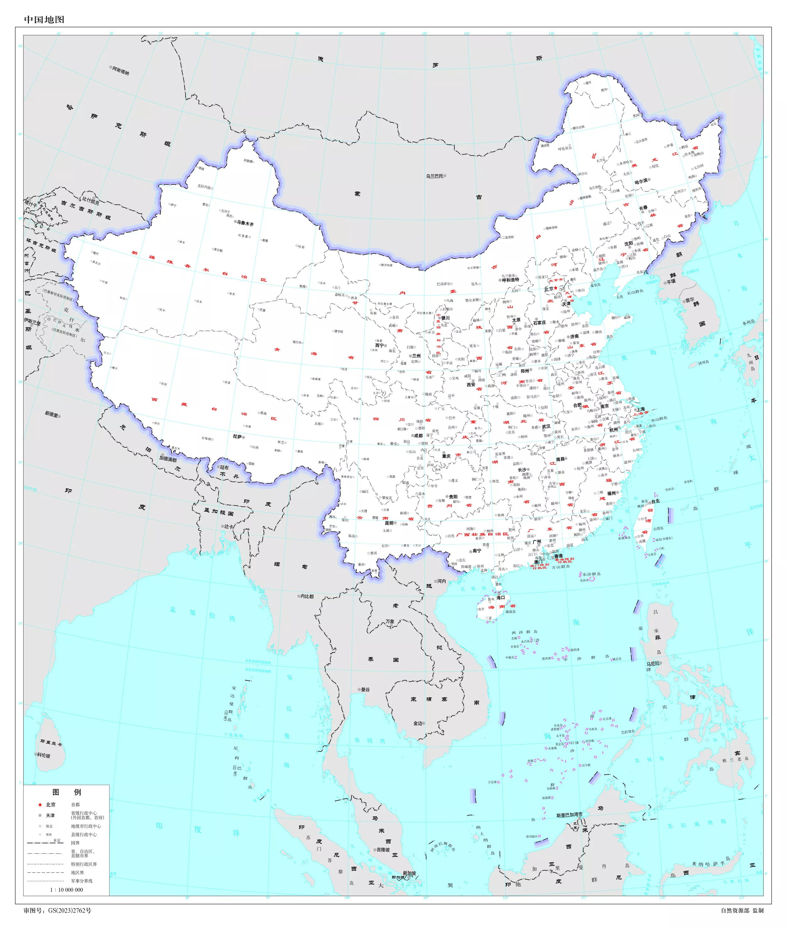
A new China map shows the South China Sea with nine-dash line claims under Chinese territory and a new line next to Taiwan are seen on the map, at a bookstore in Beijing, Friday, Sept.
1, 2023.China has upset many in the Asia-Pacific region with the release of a new official map that lays claim to most of the South China Sea, as well as contested parts of India and Russia, and official objections continue to mount.
(AP Photo/Andy Wong)


From WashingtonTimes by AP
 
China has upset many countries in the Asia-Pacific region with its release of a new official map that lays claim to most of the South China Sea, as well as to contested parts of India and Russia, and official objections continue to mount.
What is the map, and why is it upsetting people so much?

China‘s Ministry of Natural Resources released the new “standard” national map on Monday, part of what it has called an ongoing effort to eliminate “problem maps.” In it, China clearly shows its so-called nine-dash line, demarcating what it considers its maritime border, claiming almost the entirety of the South China Sea.
The current, and other recent iterations of the annual map, include a 10th dash to the east of Taiwan.
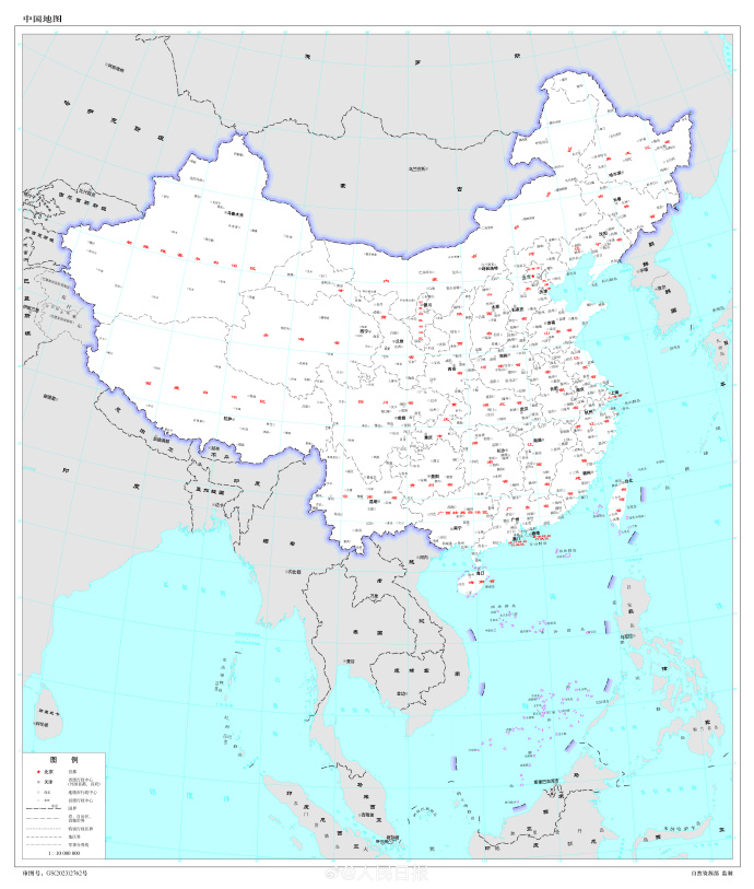
     China's new map showing parts of several countries, such as India and Russia, as its own 
The map shows new territorial borders, but the land grab has sparked protest from India, Malaysia and others
 
 Outlay of the multiple nations claimed by China’s 2023 edition of Standard Map.
 
In the far northeastern corner of China on the border with Russia, it shows Bolshoy Ussuriysky Island, an island at the confluence of the Amur and Ussuri rivers, as Chinese territory, even though the countries signed an agreement nearly 20 years ago to split the island.

Along the southern border with India, it shows Arunachal Pradesh and the Doklam Plateau, over which China and India have long feuded, clearly within Chinese borders, along with Aksai Chin in the western section that China controls but India still claims.

China‘s longstanding claims in the South China Sea have brought it into tense standoffs with Indonesia, Vietnam, Malaysia, Brunei and the Philippines, all of which have competing claims.
Chinaand India fought a war over their border in 1962, and the disputed boundary has led to a three-year standoff between tens of thousands of Indian and Chinese soldiers in the Ladakh area.
A clash three years ago in the region killed 20 Indian soldiers and four Chinese.

After the release of the map, India fired back first, saying China‘s claims have no basis.
Indian External Affairs Ministry spokesperson Arindam Bagchi said “such steps by the Chinese side only complicate the resolution of the boundary question.” It lodged a formal complaint on Tuesday through diplomatic channels.

Malaysia then rejected China’s “unilateral claims” and added that the map is “not binding” to the country.
Vietnam, Taiwan, Indonesia and the Philippines have since followed suit.

Vietnam said the claims violate its sovereignty over the Paracel and Spratly islands and jurisdiction over its waters and should be considered void because they violate the United Nations Convention on the Law of the Sea.
Illustrating how provocative the nine-dash line is considered by Hanoi, Vietnam in July banned the popular “Barbie” movie because it includes a view of a map showing the disputed Chinese claims.

The self-governed island of Taiwan, which China claims as its own, also rejects the nine-dash line and Beijing’s South China Sea claims.
1671 Dutch map of China by Arnoldus Montanus (in Latin)
 
The territorial claims at times lead to direct confrontation.
A little more than a week ago, Philippine boats breached a Chinese coast guard blockade in a disputed area of the South China Sea to deliver supplies to Filipino forces guarding a contested shoal.

In its response to the map, the Philippine Department of Foreign Affairs cited a 2016 ruling by an arbitration tribunal in The Hague under the U.N.
Convention on the Law of the Sea that largely invalidated China’s claim to virtually the entire South China Sea and upheld the Philippines’ control over resources in a 200-nautical mile exclusive economic zone.

Russia, for which Chinese support in its war against Ukraine has been critical, has not yet responded.

Chinese Foreign Ministry spokesperson Wang Wenbin sidestepped questions Thursday about specifics of the nine-dash line and why China has been using a 10th dash in recent years, telling reporters only that “China‘s stance on the South China Sea is consistent and clear.”

He also didn’t directly address the protests over the map, saying that the update was “routine practice every year” with the aim of providing standard maps and to “educate the public to use maps in accordance with rules.”
“We hope that the relevant sides can see it in an objective and rational way,” he said.
World map according to Ming dynasty in 1602

The national map is an annual production that could be released any time, and China knows well that its claims are contentious, even though they are not new.

It seems significant, then, that Beijing chose to release the map on the heels of a late August meeting of the BRICS nations - Brazil, Russia, India, China and South Africa — and just before China is to participate in top-level meetings of the Association of Southeast Asian Nations and the Group of 20 rich and developing nations.

At the BRICS meetings, the China-Russia relationship was broadly seen as strengthened as the group voted in favor of a proposal pushed by Beijing and Moscow to invite Iran and Saudi Arabia, along with four other countries, to join.
On the sidelines, Indian Prime Minister Narendra Modi and Chinese President Xi Jinping even talked about their disputed border, agreeing to intensify efforts to de-escalate tensions.

Most of the governments with which China has disputes in the South China Sea are ASEAN members, and India is hosting the G20 talks.

In releasing the map now, Beijing is widely seen as signaling it has no intention of backing down on any of its claims and is making sure that its positions are fresh in the minds of other countries in the region.

Links :

Tuesday, September 5, 2023

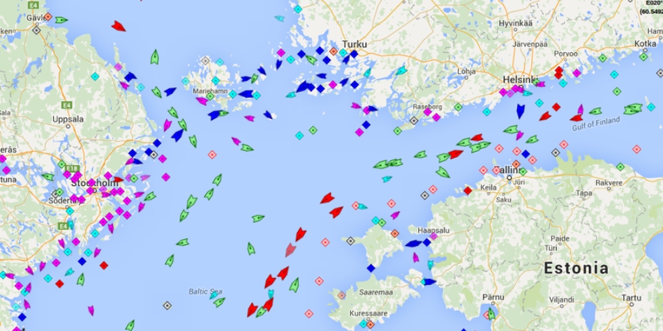
AIS data : the danger in the hands of novices


From Navigate Response by Dustin Eno


In the hands of people without an adequate understanding of our industry AIS data causes problems

Automated Identification System (AIS) data is a valuable tool for tracking ships and maritime activities.
It is used by various parties, including journalists, researchers, and the public, to monitor vessel movements and gather information about shipping trends.
However, despite the fantastic user interfaces created by platforms like MarineTraffic, AIS data is too often misinterpreted, leading to incorrect conclusions and false narratives.

In the hands of people without an adequate understanding of our industry AIS data causes problems which fall roughly into three categories:

Errors in AIS data that are obvious with context, but that are nevertheless not questioned and are instead taken as fact.

In 2019, as oil was washing up on Brazilian beaches, investigators were trying to identify the source of the spill.
The Brazilian Laboratory of Satellite Image Analysis and Processing looked at satellite imagery to track the oil at sea and then used AIS data to identify which vessels had been in the area.

One ship was identified and an “expert” presented the vessel’s name to a senate committee and the public as the culprit.
There was just one problem, the vessel was 12,000km away in India at the time.
An error in the AIS data showed her in the Atlantic for about 24 hours around the time the spill was believed to have happen.
Obviously, it would be impossible for a large tanker to relocate from India to Brazil and back in the span of a couple days.
Some involved indicated that the “unusual” movement of the vessel was part of the reason she was suspected.
Unusual? Try impossible! But the data was not doubted as it should have been.

We were able help our client to clear their name, but it took weeks to get all the allegations removed.
With a little critical analysis of the data, the vessel never should have been under suspicion in the first place.

Switching AIS to low power mode is misinterpreted as going “dark” for nefarious purposes.

As a safety precaution, the power setting on the AIS units on tankers is routinely reduced from 12.5W to 1W while the vessel is berthed or engaged in cargo operations.
If an AIS receiver is nearby this will have no impact and the data will still be received without interruption, but if the receiver is further away it may no longer be able to pick up the weaker signal and this could be mistaken for the tanker turning off its AIS – perhaps to hide while doing something wrong…

We see this issue arise during ship to ship (STS) transfer operations which generally happen in more remote areas farther from receivers.
It is true that some operators do turn off their AIS to hide STS operations (for example if in breach of sanctions).
Unfortunately, some observers also assume this is what has happened in completely innocent cases when in fact the AIS has just been switched to low power mode as per standard operating procedures.

We’ve dealt with numerous enquiries from well-intentioned journalists along the lines of:“your client’s vessel arrived at _______ turned off her AIS and, when she turned it back on, had a larger draft suggesting she’d loaded cargo in an STS operation.
Why was the AIS turned off?
What is she hiding?”

Convincing a journalist, or worse an activist, that in fact the AIS was on the whole time is difficult, especially if they believe they’ve caught the vessel / company in the act of doing something dodgy.
 
 
Attacking Open Source Intelligence: The Fake AIS data epidemic explained
Everyone (and their mother) has discovered AIS signals. 
When there is a major confrontation at sea, or a ship gets stuck in the Suez Canal, it's a race to the data used to track ships.
But like any form of Open Source Intelligence (OSINT) the signals you get may be misleading.
They may even be fake.
In fact tat is happening more and more frequently.
Here's how. Article on Yantar spy ship http://www.hisutton.com/Yantar.html
 
The AIS track on a map is visually easy to interpret, but only tells one part of the story and without context can be badly misleading.

One AIS platform famously caught the Ever Given “drawing” male genitals in the southern Suez anchorage before going on to blook the canal some hours later.
Of course, the pattern was purely coincidental and was visible only on this platform due to the exact moments that they captured the data.
On all other platforms the track of the vessel looked purely random.

A vessel drifting in the Baltic Sea last year was absurdly accused by some on Twitter of being involved in damaging to the Nord Stream pipeline simply because she was floating in the rough proximity of the damage at roughly the same time while awaiting orders.

In another story, tanker 1 called in Russia and then a couple weeks later met tanker 2 which had come from Iraq via Turkey; after meeting tanker 2 proceeded to Greece.
A journalist with a major outlet reported that an STS operation moved Russian oil from tanker 1 to tanker 2 so that it could be imported into Greece.
In reality, tanker 2 needed an unscheduled drydock and so transferred the remainder of its Iraqi cargo to tanker 1 and arrived in Greece empty ready for drydocking.

All understandable conclusions if one approaches the data with suspicion and doesn’t check the fuller context, but all wrong.
And obviously wrong with a little investigation.

What’s the conclusion?

It is easy to be angry with the social media users and journalists who make accusations based only on an incomplete understanding of AIS data.
Being angry is justified, but not useful.

Instead, these misunderstandings and assumptions, most of which stem from a distrust of our industry, are a reminder that as an industry we must continue to do more to explain our operations.

Explain AIS data.
And build trust with our ultimate stakeholders – the general public.

Links :
 

Monday, September 4, 2023

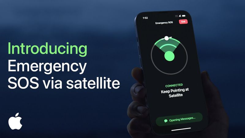
Globalstar enlists Elon Musk’s SpaceX to launch satellites for Apple's iPhone SOS feature

Globalstar, a Covington-based communications company, has been selected to serve as the satellite operator for Apple’s new emergency SOS service
 
From NOLA 

Globalstar has enlisted Elon Musk’s SpaceX to launch a host of satellites it will use to provide a communications network for an emergency Apple iPhone feature, the Covington satellite technology firm said Thursday in a federal filing.
 
 As part of a deal signed Monday, Globalstar will have to pay SpaceX a total of $64 million for “launch-related payments on a periodic basis” from now until the satellites are sent into space in 2025, according to its Securities and Exchange Commission filing. SpaceX is the spacecraft manufacturer founded by Musk, who is CEO of Tesla and owns X, the social media platform formerly known as Twitter.

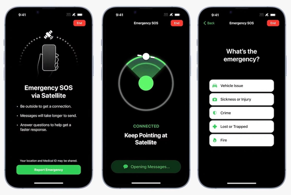
The satellites will support the emergency SOS services Globalstar is providing to Apple’s iPhones.
The feature allows iPhone 14 users to tap into satellite networks to send messages or calls if they are far away from cell towers.

Globalstar bought those satellites in February 2022 from Canadian company Macdonald, Dettwiler and Associates Corp. for $327 million.
Apple loaned Globalstar $252 million to help finance that purchase.

This isn’t the first time Musk’s launch company has helped Globalstar.
Last year, SpaceX helped Globalstar launch a satellite from the Kennedy Space Center in Cape Canaveral, Florida.

Globalstar made waves earlier this week when it announced it would hire Paul Jacobs, a Silicon Valley darling and former Qualcomm executive, as its CEO.
 
Links :


Keeping tabs on China’s murky maritime manoeuvres

Chinese fishing fleet (August 16th)

From The Economist

America and its allies are using whizzy new tools to track China’s military activity and illegal fishing

In january 2021 a fleet of Chinese fishing vessels approached the coast of Oman, apparently searching for squid.
According to the ships’ automatic identification transponders, they stayed just outside Oman’s Exclusive Economic Zone (eez), which grants it control of fishing rights up to 200 nautical miles (370km) from its shores.
But radio signals from the ships, detected by commercial satellites, told a different story.
They indicated that the ships were operating within Oman’s eez in a suspected illegal raid on the Gulf state’s valuable squid stocks.

That was an early demonstration of a new tool being used by America and its allies to help expose illegal or aggressive Chinese activity at sea.
They are contracting private companies to provide governments across the Indo-Pacific region with near-real-time data, gathered from space, to help them monitor coastal waters and to use their limited naval and coast-guard resources more effectively.

The data are being provided as part of the Indo-Pacific Maritime Domain Awareness initiative, or ipmda, which was launched in May 2022 at the second leader’s summit of the “Quad”—a bloc comprising America, Australia, India and Japan.
It is now one of the clearer examples of how that grouping is trying to add substance to its rhetoric about defending a “free and open” Indo-Pacific against Chinese military and economic coercion.

But it also highlights the sensitivities involved in a region where many countries fret about China’s military activity and illegal fishing, but are wary of challenging it directly or being drawn into its escalating confrontation with America.
The Chinese government has already indicated that it sees the ipmda as part of an American-led effort to “build small cliques and stoke bloc confrontation” against China.

When the Quad’s leaders met again in May 2023, they said that the ipmda was already providing data to governments in South-East Asia and the Pacific, and would expand to the Indian Ocean in the coming months.
They avoided mentioning China, emphasising instead the data’s utility in combating illegal, unreported or unregulated fishing, and in responding to humanitarian crises.

At a security conference the next month, however, American and allied military commanders emphasised the strategic significance of the programme whereby information is shared through data “fusion centres” in India, Singapore, Vanuatu and the Solomon Islands (see map).
These have existed for some years but have not shared data fast enough or in sufficient detail.
Individual governments have also been wary of sharing classified information.


“The architecture’s there,” Admiral John Aquilino, commander of America’s Indo-Pacific Command, told a panel session at the conference in June.
“The sensing needs to be increased and then the sharing needs to be done” in the Indian Ocean region, he said, suggesting that a maritime security centre in Oman could be included.

On the same panel, India’s deputy national security adviser, Vikram Misri, said the fusion centre just outside Delhi had already exchanged data with more than 22 countries and hosted liaison officers from nearly a dozen.
France’s chief of navy staff, Admiral Pierre Vandier, called for efforts to combine military and civilian tools, and suggested incorporating another data centre in Madagascar to help cover the southern Indian Ocean.

Chinese experts, meanwhile, say the ipmda is designed to discredit China’s maritime activities, especially those of its vast fishing fleet, which has been accused of illegal operations around Africa, South America and the Pacific islands.
The Quad’s programme will soon expand to target Chinese coast guard and navy ships, predicts Hu Bo of Peking University.

Western defence experts, too, have highlighted the IPMDA’s military applications.
It “develops organisational infrastructure and surveillance practices that the Quad and its partners could repurpose for military operations, including monitoring a Chinese move against Taiwan,” the Centre for Strategic and Budgetary Assessments, a Washington-based think-tank, said in July.
It suggested augmenting the programme with aerial drones.

Quad officials are reluctant to say exactly which countries see the data.
But America’s vice-president, Kamala Harris, revealed that the Philippines was among them when she visited there in November.
That country has been revitalising its alliance with America in recent years, largely in response to China’s efforts to enforce its maritime claims in the South China Sea, which are disputed by the Philippines and four other South-East Asian countries.

One of the challenges for those countries is that Chinese coast-guard and fishing vessels help to enforce maritime claims but often deactivate the Automatic Identification System (ais) transponders that broadcast their identity and location.
At other times, Chinese ships transmit “spoofed” data, manipulated to be inaccurate.
Chinese survey vessels have also operated across the Indo-Pacific without transmitting AIS data in recent years.

Even Chinese cargo ships have become harder to track using conventional methods since 2021, when many stopped transmitting ais data following passage of a new law that China said was necessary to thwart foreign intelligence-gathering.
However, new means of ocean surveillance are emerging thanks to private satellite operators offering services including high-resolution photography, radio-frequency monitoring and synthetic-aperture radar (which generates images by bouncing microwaves off the Earth’s surface).
Artificial intelligence also enables much faster analysis of such data and imagery.

The view from on high

Among ipmda’s contractors is HawkEye 360, a Virginia-based company founded in 2015.
It operates a constellation of 21 low-Earth orbit satellites monitoring the radio-frequency signals from navigation, security and communication equipment that ships use even if ais transponders are deactivated.
That can then be cross-referenced with satellite images and other information to identify and locate ships.

HawkEye 360 says it used its data to help identify Chinese vessels suspected of illegal fishing off Ecuador in 2020, as well as the squid-fishing fleet near Oman in 2021.
It has also tracked Chinese coast-guard vessels in disputed parts of the South China Sea.
Its satellites can now cover about 10m sq km in one pass and another cluster can return to the same area within about 60 minutes, says John Serafini, the firm’s chief executive.
Getting data to clients can take between a few minutes and an hour, he adds.

The company declined to specify the value of its ipmda contract but said that it provides the data directly to the American government, which then distributes it to the programme’s participants.
In addition, the Australian government contracted HawkEye 360 in July to provide its data to the Pacific Islands Forum Fisheries Agency, which helps its 17 member countries to manage their tuna stocks.

That agency is based in the Solomon Islands, which caused alarm among American and allied officials in 2022 when it signed a security agreement with China that they fear could lead to a Chinese military base there.
China and the Solomons deny any such plans but America and its main regional ally, Australia, have since expanded their diplomatic contacts with the Pacific islands and offered to boost financial and military assistance.

The hope now among Western officials is that by focusing such efforts on illegal fishing and other areas of real concern to Indo-Pacific nations, they will win broader support for American and allied efforts to counter China.
Whether that will alter Chinese behaviour is another question: fishing and territorial claims are both touchy issues for its leadership.
But shining a light on murky maritime manoeuvres seems like a good place to start.


Links :