Saturday, August 18, 2012

Shark spy camera

Filmmaker Jeff Kurr On Shark Week's New Noninvasive Device


Shark Week 2012 has been full of great footage, including shots of leaping great whites and amazing underwater scenes.
But one particularly impressive piece of equipment, featured in "Air Jaws Apocalypse," may be the future of shark observation.

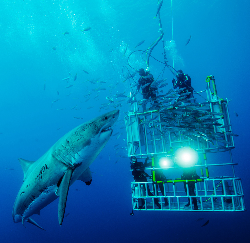
The Shark Spy camera fulfills a simple objective: get eyes in the water without actually getting in the water.
As Shark Week filmmaker Jeff Kurr explained to The Huffington Post, this benefits sharks and shark observers alike.
"Boats, divers, bait and chum can alter a sharks' natural behavior," Kurr wrote in an email to HuffPost.
"To truly understand and learn about these animals we certainly want to see what they're doing naturally, without those outside influences... there's a lot more to sharks than just feeding time."

In addition to protecting sharks from the stress of invasive research projects, the Shark Spy's remote viewing capability also removes divers from the dangers -- and limitations -- of working in shark-infested waters.

"Shark Spy lets us go deeper into the world of the great white shark without risk of bodily harm to us," Kurr wrote.
"It also allows us to spend a great deal of time with these animals without the restriction of limited [diving time] you have to deal with on SCUBA. "

The new technology has already helped unravel a mystery.
On "Air Jaws Apocalypse," Shark Spy allowed the crew to see why the great whites were visiting an inshore reef that was too dangerous for diving.
Through use of the camera, the team discovered that the great whites were preying on other sharks.

"In the past, to learn about a great whites' diet, you had to cut the shark open and kill it to see what it'd been eating.
Obviously, we don't want to have to kill these animals to learn about them. Especially considering their highly vulnerable status," Kurr said.

Environmentalists are currently working to add great white sharks off the California coast to the endangered species list, Reuters reports.
Studies suggest there are fewer than 350 of the sharks in the area.

Groups say the sharks are "threatened by chemical contaminants" and sometimes get caught in "fishing nets," according to KTVU.

Friday, August 17, 2012

Wreck of Captain Scott's ship discovered off Greenland

The Terra Nova carried Captain Scott and his party on their ill-fated expedition to the Antarctic

 From BBC

The wreck of the ship that carried Captain Robert Scott on his doomed expedition to the Antarctic a century ago has been discovered off Greenland.
The SS Terra Nova was found by a team from Schmidt Ocean Institute, a US research company.

 Sonar mapping revealed an unidentified feature on the seafloor

Scott and his party set off from Cardiff aboard the Terra Nova in 1910 with the aim of becoming the first expedition to reach the South Pole.
The ship had a life after the polar trek, sinking off Greenland's south coast in 1943.
It had been on a journey to deliver supplies to base stations in the Arctic when it was damaged by ice. The Terra Nova's crew was saved by the US Coast Guard cutter Southwind.

On arriving at the geographical South Pole in January 1912, Scott and his party discovered they had been beaten to it by a Norwegian team led by Roald Amundsen.
The polar team led by Scott died on their return journey from the pole; their bodies were found by a search party eight months later.

A crew from the Schmidt Ocean Institute discovered the Terra Nova whilst testing echo-sounding equipment aboard its flagship vessel - the R/V Falkor.
One of the scientists noticed an unidentified feature during sonar mapping of the sea bed.

Team members then noted that the 57m length of the feature
matched the reported length of the Terra Nova.

Technicians dropped a camera package called Shrimp to just above the presumed wreck to film it.
Camera tows across the top of the target showed the remains of a wooden wreck laying on the seabed.
Footage from an underwater camera also identified a funnel lying next to the ship.

 A camera package called Shrimp was sent down to film the wreck

Taken together, the features of the wreck closely matched historical photos of the Terra Nova, leading to the identification.

 S.S. Terra Nova funnel as seen in the underwater video frame filmed from R/V Falkor using SHRIMP (Simple High Resolution IMaging Package).

Brian Kelly, an education officer from the Discovery Point museum in Dundee, where the ship was built, told the Daily Record newspaper: "The Terra Nova has such a story."
She went through a lot in her lengthy history and really was the pinnacle of Scottish wooden shipbuilding.
"It is incredible that one of the most famous ships in history has been found 100 years after the race for the pole and in the year commemorating the event.

Links :
  •  TheTelegraph : Wreck of Captain Scott's ship discovered off Greenland

Thursday, August 16, 2012

Premiers essais embarqués de l'appli iPad Carte Marine France

Hier à l'occasion de la troisième édition de la biennale d'art contemporain Estuaire, l'équipe GeoGarage a pu tester pendant une durée de 3 heures l'application Carte Marine France proposant un accés aux cartes du SHOM sur iPad durant une balade le long de la Loire entre Nantes et Saint Nazaire

Accès aux cartes SHOM sur les serveurs GeoGarage via 3G-Edge

Le parcours de Nantes à Saint Nazaire

 Petit détour près de Paimboeuf pour mieux voir le Jardin Etoilé de Kinya Maryyama

'La maison dans la Loire' de Jean-Luc Courcoult
vu du fleuve, qui a pris définitivement ses quartiers à Couëron.
A découvrir depuis l'estacade du quai Pont-Gibeau (A 200 mètres de la Tour à Plomb).

'La maison dans la Loire' installée à Couëron en mai 2012
pas encore sur la carte du SHOM 7396, ni sur l'imagerie aérienne de Google (voir)

Ocean health index unveiled


Ocean Health Index provides valuable data.
The earth's oceans are at risk.
Now we can assess the future for our water, our fish and ourselves, if we continue as we are.

From Nature


Taking a page from the financial sector’s use of the Dow Jones industrial average to track economic 'health', marine researchers have created an index that assesses overall ocean vitality.

Global map of marine health index scores. 
All waters within 171 Exclusive Economic Zones (EEZs) were assessed.

The index, described this week in Nature, comprises ten disparate measures that are aggregated into a single score of how well the seas are doing.
The ten measures — which assess features such as food provision, carbon storage, tourism value and biodiversity — were chosen to reflect both the needs of humans and ecosystem sustainability.

Posting a global score of 60 out of 100, the index offers a seemingly gloomy outlook.
Almost one-third of the world's countries scored below 50.
But the study authors say that the range of scores for individual countries — from 36 to 86, with 5% of nations scoring higher than 70 — implies that there are successes amid the areas of concern.


  The new Ocean Health Index is designed to assess the importance of the seas to people as well as other species. Here, a man paddles over a coral reef in Bird's Head, Raja Ampat, Indonesia.

“This should not be considered a failing grade for the oceans,” says Karen McLeod, a study co-author and the director of science at COMPASS, a non-profit science-communication organization based across the west coast of the US.
“The real value of the index will be the ability to track progress related to management policies over time,” she adds.

Many marine researchers who were not involved in designing the index agree that useful indicators of ocean health are woefully lacking.
Hundreds of specific indicators already exist, but none does a comprehensive job of integrating different sources of information.

Jane Lubchenco, head of the US National Oceanic and Atmospheric Agency (NOAA) in Washington DC, says the index is “a great leap forward in society’s attempts to understand what the trade-offs are for management decisions”, noting that President Barack Obama's National Ocean Policy calls for a more holistic look at oceans.

 Commercial fishermen and other mariners join together to send an urgent message to save the oceans from ocean acidification caused by fossil fuel emissions in Homer, Alaska, on September 6, 2009.
Over a hundred boats and hundreds of members of the fishing community participated in the event.
UPI/ Lou Dematteis/Spectral Q

Inner workings

Some have raised concerns about how the index assesses fisheries, which were given a global health score of just 25, lower than any other measures except for tourism and recreation (which are grouped as one measure) and mariculture (the farming of fish and other sea creatures).

The fisheries score is calculated as the difference between a region’s total landings and an estimate of maximum sustainable yield.
For fisheries containing many species, 75% of the maximum sustainable yield was used.

“I’m concerned [that] managers will wrongly interpret a score of 25 to mean that we could quadruple catches — which is far from being sustainable,” says Trevor Branch, a fisheries expert at the University of Washington in Seattle. Ray Hilborn, a fisheries scientist also at the University of Washington, suggests that not enough is known about maximum sustainable yield in many countries for this metric to be used with any confidence.

A new Ocean Health Index developed at Stanford's Center for Ocean Solutions evaluates several factors of ecosystem health.

Gaining traction

Whether policy-makers will adopt the ocean health index is the big question. “Getting a metric or index to gain traction among decision-makers is sort of a dark art,” says Damon Stanwell-Smith, coordinator of the Biodiversity Indicators Partnership, at the United Nations (UN) Environment Programme World Conservation Monitoring Centre in Cambridge, UK.
“People can be quite contrary and will look to undermine anything set up as the ‘best way’ of doing something; the ocean health index is most likely to succeed globally if it’s a slow burner."

The 10 components of the Ocean Health Index and the global score each received

The index will soon get exposure.
In October, it will probably be among the metrics considered by the Conference of the Parties to the Convention on Biological Diversity in Hyderabad, India.
It may also prove useful in the UN General Assembly’s first global integrated marine assessment this autumn.

For her part, Lubchenco thinks that the index will be most readily adopted by institutions that manage places rather than particular sectors, such as the NOAA's National Marine Sanctuaries or the state of Rhode Island, which has one of the most comprehensive marine management plans of any US state.

Links :
  • NationalGeographic : New Ocean Health Index Measures the Global State of the Seas 
  • ESA : Sea sick? Setting targets to assess ocean health and ecosystem services

Wednesday, August 15, 2012

The blue : face to face with dolphins

While fishing tuna 20 miles off the coast of Santa Cruz, California, Mark Peters dropped his GoPro Hero 2 inside a custom-made torpedo case in the water to see what he could catch.
The camera captured amazing footage a pod of Pacific White-Sided dolphins swimming along with their boat.

Tuesday, August 14, 2012

Underwater drones tested by U.S. Navy in Narragansett Bay

Unmanned underwater drones

From HuffingtonPost

Just beneath the placid, sailboat-dotted surface of Narragansett Bay, torpedo-shaped vehicles spin and pivot to their own rhythm, carrying out missions programmed by their U.S. Navy masters.

The bay known as a playground for the rich is the testing ground for the Naval Undersea Warfare Center in Newport, where the Navy is working toward its goal of achieving a squadron of self-driven, undersea vehicles.

One of the gadgets recently navigated its own way from Woods Hole, Massachusetts, to Newport, completing several preset tasks in what the military calls an unprecedented feat.

Technology under consideration by the military is often tested aboard cylinder-shaped vehicles with a diameter of about 20 inches (50 centimeters).
But the center also tests its own prototypes, including one dubbed Razor, which can propel itself by using flippers, like a turtle, for stealth.

The Navy hopes its drones will eventually pilot themselves across oceans.
The vehicles are already used to detect mines and map the ocean floor and, with tweaks over the next several years, the military says they will be applied more to intelligence gathering and, in the more distant future, anti-submarine warfare.

"We do see these autonomous undersea vehicles as game changers," said Christopher Egan, a program manager at NUWC.

The "Razor," an autonomous underwater vehicle (AUV) sits in a lab at the Naval Undersea War Center in Middletown, RI., Tuesday, July 31, 2012.
Narragansett Bay is the testing ground for the Naval Undersea Warfare Center where the Navy is working toward its goal of achieving a squadron of self-driven, undersea vehicles. (AP Photo/Stephan Savoia)

Compared with aerial drones, the undersea vehicles can be challenging to control from a distance. The water distorts the transmission of signals, and the drones have to contend with boat traffic, swirling currents and obstacles on the ocean floor.

They are typically powered by batteries, but their endurance has been sharply limited by the lack of a stronger power source that will allow for safe handling by sailors who deploy and collect the devices aboard submarines.
With advances in alternative energy sources, particularly fuel cells, the Navy says it is close to achieving a fully independent drone.

By 2017, the Navy aims to have a large, unmanned vehicle that can stay out for 70 days. Within the next decade, it wants to field its first full squadron.
"We've seen the advances of unmanned aerial vehicles and what that provides to the war fighter," said Navy Capt. Brian Howes, who is involved in planning for the vehicles as commander of Submarine Development Squadron 5 in Washington state.
"We're pushing the technology to have the same leap for our unmanned undersea vehicles."

In a time of tight federal budgets, the Navy also sees drones as a cost-effective way to extend the reach of its submarine fleet, which has been gradually shrinking in size since the end of the Cold War.

Norman Friedman, a New York-based naval analyst, said the unmanned undersea vehicles — or UUVs — are a necessary investment.
Whether they deliver on their promise, he said, will depend on success at finding the right power plant.
"The big obstacle is going to be energy," he said. "I don't get the feeling anyone has jumped up and said this is not a problem anymore."

 Christopher Del Mastro, head of anti submarine warfare mobil targets at the Naval Undersea War Center, stands next to a mock up of their Manta Test Vehicle in Middletown, RI., Tuesday, July 31, 2012.
The bay is the perfect testing environment, with shallow water, varied features on the bottom and commercial traffic, Egan said.
At times, however, the engineers have to contend with interference from pleasure boaters, including one man who was approached by a Navy vessel after trying to grab a vehicle near the surface.

"We've had occasional interactions where a boat operator sees an opportunity to maybe snap up a cool device," Egan said.
"We've had to deter them on occasion."

The four-foot-long, 88-pound SeaFox drones cost $100,000 each.
A reusable version of the SeaFox uses sonar and color CCTV to navigate and search for targets.

The Navy has used unmanned vehicles to simulate enemy submarines for training purposes since the 1970s, but officials say they have made dramatic leaps in autonomy.

The vehicle that completed the 26-hour voyage from Cape Cod to Newport in October 2010, for example, plotted its own course without relying on GPS positioning or other communications, Egan said.
Guiding itself by features on the sea floor, it passed through the pylons of a bridge, circumnavigated the island of Jamestown and surfaced in a pre-determined spot inside the harbor.

The laboratory at the Naval Undersea Warfare Center, which has 65 engineers and scientists dedicated to UUVs, works closely with private companies, academic institutions and other government agencies involved in similar research.
The gadgets have a wide range of applications beyond the military, as demonstrated last year by vehicles that recovered the flight data recorder from an Air France plane that crashed in the mid-Atlantic.

The submarine community is particularly eager to see what the vehicles can do.
Electric Boat in Groton, Connecticut, has designed a module to help future attack subs deploy and recover the drones, transporting them through the payload tubes.
"If you can do reconnaissance with multiple UUVs or one UUV, then in effect you extend the area the submarine touches," Friedman said.

Links :
  • Inquisitr :  US Deploys underwater drones to monitor Persian Gulf as Iranian threat grows
  • Gizmodo : The SeaFox Mine Sweeper will destroy Iran’s explosives in the Strait of Hormuz

Monday, August 13, 2012

Fishers, divers help track marine species

Fisher, divers and beachgoers alike can contribute to a tracking map of species they see.
(Credit: Rick Stuart-Smith)

From AustralianGeographic

Thanks to a helping hand from the public along with government grants, scientists will be able to map the migration of fish, turtles, sharks and other marine species around the Tasmanian coast.


In 2009, researchers from the University of Tasmania set up the interactive REDMAP (Range Extension Database and Mapping Project) website, where fishers, divers, swimmers, and beachgoers could report the presence of marine species in in local Tasmanian seas.
The aim was to identify sea creatures' marine habitat and what may be altered by climate change.

Originally exclusive to Tasmania, the project will expand to the whole Australian coast in November 2012.
"REDMAP acts as an important early indicator for new species being reported in an area they have not been found in before" says Phillip Glyde, deputy secretary of the federal Department of Agriculture, Fisheries and Forestry,  which helped fund the expansion of the REDMAP project through the Climate Change Research program.


Marine conservation help from fishers

Thanks to member sightings, REDMAP has shown that some species of fish tend inhabit areas further south than they are usually found.
Increasing sea temperature driven by climate change may force fish to travel south to cooler waters, the researchers say.

For Dr Alexandra Campbell, an ecologist from the University of New South Wales, making REDMAP available to 3.5 million fishers and divers nationwide is a boon for science.
"Using this sort of unconventional tool for gathering data on the location and condition of marine species is essential in a country like Australia, which has an extensive coastline and limited resources to carry out specialist monitoring programs" she says.

Researchers hope the program will raise awareness of the impact of climate change on marine life.
"We're involving people in the discovery of how our ecosystems are changing - engaging people in the science of climate change through activities they enjoy like fishing and diving" says Dr Gretta Pecl, a marine ecologist at the University of Tasmania and principal researcher for REDMAP.
"People are very happy about having something valuable to contribute to scientific research."

A smart phone application is being be developed to enable Australian fishers, boaters or divers to log sightings and photos of uncommon species instantly and on the spot.
These will be checked by scientists at REDMAP and instantly mapped on the website.

Sunday, August 12, 2012

Images from National Geographic

Just before a huge monsoon downpour, the ocean became flat as I have never seen before.
It was drizzling a bit, people were on their way to their house, when I walked up this pier.
The light rain made the pier mirror-like, and the ocean was so calm.
On the horizon are the islands just in front of Makassar, part of that special islands of Sulawesi. Makassar, Indonesia. (Photo and caption by Erik Kievit)

Children filled with happiness playing in the water. Brazil. (Photo and caption by Seth Solo)

Sunbathing underwater : The sun gives us energy even underwater.
This image was captured during freediving (diving on a single breath without scuba gear) in the Red Sea. Eel Garden, Dahab, Sinai, Egypt.
(Photo and caption by Vaclav Krpelik)

This image was captured to Sandbar, Grand Cayman during my last trip.
This beautiful creature turn around you very close and you can touch it.
This is a really amazing experience, you are surrounded by dozen of this friendly animal. Sandbar-Grand Cayman-Caribean
(Photo and caption by Gazzaroli Claudio)

Confronting : cage divers confront a great white shark on the Isla de Guadalupe.
(Photo and caption by David Litchfield)

Patterns of sea stars as exquisite mosaics, attractive, and each time is different. Cambodia (Photo and caption by Andrey Narchuk

Photo & caption by Guy L. Brun
The upper Bay of Fundy, where this picture was taken in early August of 2011, is an important staging area for migratory birds on their long flight south.
Here, a flock of semipalmated sandpipers is in full motion after being spooked by a falcon looking for a tasty meal.

Photo & caption by Sarah Jones
I had just finished photographing surfers when this school of dolphins came through.
For once I had my camera with me and was able to get the shot!

Photo & caption by Tony Heff
Golden hour at Ala Moana Harbor, Honolulu. Ocean paddlers race the evening light back to the shore.

Photo & caption by Victorio Duran
Soft and gentle waves.
Taken a few hours after the sun set behind the horizon.
Location: Nagbalayong, Morong, Bataan, Philippines.

Photo & caption by Dafna Ben NunWhile diving with beluga whales in the Arctic, I managed to capture the O-shaped air coming up.

Photo & caption by Louis Hiemstra
As the sun rises over False Bay near Cape Town, three elderly ladies brave the icy water of Boulders Beach.

Photo & caption by Chris Kotsiopoulos
Fire in the sky! This is an image sequence containing 70 lightning shots, taken on Ikaría island, Greece, during a severe thunderstorm that took place June 16, 2011.
In order to make the sequence, I set the camera to a tripod taking 20-second shots.
After 83 minutes I ended up with this wall of lightning!


 Jellyfish (Cotylorhiza tuberculata) drifting just beneath the surface, looking to capture the first sunrays to trigger their symbiotic algae to produce energy for it.  Mar Menor coastal lagoon, Murcia province, Spain. (Photo and caption by Angel Fitor)

A beautiful rainbow after the rain, into the green zone of the Palawan Islands.
Onuk island, Balabac Palawan, Philippines. (Photo and caption by George Tapan)

Once a year, Formosa fishermen’s unique sulfuric fire fishing ritual is handed down from generation to generation. Taipei, Taiwan. (Photo and caption by Hung-Hsiu Shih)

An example of photo luminescence in coral in West Papua (Photo and caption by Stephen Martin)

The edge of an iceberg floating just off the coast of Antarctica. (Photo and caption by Mike Matas)

Andrew and his friend, a young sperm whale named Scar, were swimming together off the west coast of Dominica. The two of them became "friends" after Andrew saved Scar's life. (Photo and caption by Peter Allinson)

When the wave conditions are right a wave appears, infrequently, as a result of the splash back off the cliff connecting with an incoming wave. This causes the incoming wave to pop up, creating fan-like shapes. On this particular day, over the two hours I spent on the rocks, this wave only appeared once. This is that shot. (Photo and caption by Aaron Feinberg)

Curious gulls on Sanibel Island, Florida. Meet my friend, "Gull-i-Bel"!!! (Photo and caption by Richard Rush)

Links :