1745 Seale Map or Chart of the Mediterranean Sea - Geographicus
1756
Mediterranean
Archipelago Surveyed by Captains R.Copeland, T.Graves, & T.Spratt
and the Officers of H.M.S. Mastiff, Beacon, Volage, & Medina, 1832
to 1863 with additions and corrections to 1881.
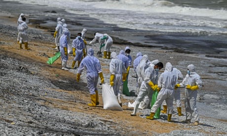
We’ve barely explored the darkest realm of the ocean. With rare-metal mining on the rise, we’re already destroying it.
The International Seabed Authority is headquartered in Kingston, Jamaica, in a building that looks a bit like a prison and a bit like a Holiday Inn. The I.S.A., which has been described as “chronically overlooked” and is so obscure that even many Jamaicans don’t know it exists, has jurisdiction over roughly half the globe.
Under international law, countries control the waters within two hundred miles of their shores. Beyond that, the oceans and all they contain are considered “the common heritage of mankind.”
This realm, which encompasses nearly a hundred million square miles of seafloor, is referred to in I.S.A.-speak simply as the Area.
Scattered across the Area are great riches. Mostly, these take the shape of lumps that resemble blackened potatoes. The lumps, known formally as polymetallic nodules, consist of layers of ore that have built up around bits of marine debris, such as ancient shark teeth. The process by which the metals accumulate is not entirely understood; however, it’s thought to be exceedingly slow. A single spud-size nugget might take some three million years to form. It has been estimated that, collectively, the nodules on the bottom of the ocean contain six times as much cobalt, three times as much nickel, and four times as much of the rare-earth metal yttrium as there is on land. They contain six thousand times as much tellurium, a metal that’s even rarer than the rare earths.
The first attempts to harvest this submerged wealth were undertaken nearly fifty years ago. In the summer of 1974, a drillship purportedly belonging to Howard Hughes—the Hughes Glomar Explorer—anchored north of Midway Atoll, ostensibly to bring up nodules from the depths. In fact, the ship was operated by the C.I.A., which was trying to raise a sunken Soviet submarine. But then, in a curious twist, a real company called Ocean Minerals leased the Glomar to collect nodules from the seabed west of Baja California. The president of the company likened the exercise to “standing on the top of the Empire State Building, trying to pick up small stones on the sidewalk using a long straw, at night.”
After the Glomar expeditions, interest in seabed mining waned. It’s now waxing again. As one recent report put it, “The Pacific Ocean is the scene of a new wild west.” Thirty companies have received permits from the I.S.A. to explore the Area. Most are looking to slurp up the nodules; others are hoping to excavate stretches of the ocean floor that are rich in cobalt and copper. Permits to begin commercial mining could be issued within a few years.
Proponents of deep-sea mining argue that the sooner it starts the better. Manufacturing wind turbines, electric vehicles, solar panels, and batteries for energy storage requires resources, often scarce ones. (Tellurium is a key component in thin-film solar panels.) “The reality is that the clean-energy transition is not possible without taking billions of tons of metal from the planet,” Gerard Barron, the chairman of the Metals Company, one of the businesses that holds permits from the I.S.A., observed a few months ago. Seafloor nodules, he said, “offer a way to dramatically reduce” the environmental impact of extracting these tons.
But seabed mining poses environmental hazards of its own. The more scientists learn about the depths, the more extraordinary the discoveries. The ocean floor is populated by creatures that thrive under conditions that seem impossibly extreme. There is, for example, a ghostly pale deep-sea octopus that lays its eggs only on the stalks of nodule-dwelling sponges. Remove the nodules in order to melt them down and it will, presumably, take millions of years for new ones to form.
Edith Widder is a marine biologist, a MacArthur Fellow, and the author of “Below the Edge of Darkness: A Memoir of Exploring Light and Life in the Deep Sea” (Random House). Widder is an expert on bioluminescence, a topic that she became interested in after nearly going blind. In 1970, when she was a freshman in college, she had to have surgery for a broken back. The surgery went fine, but afterward she started hemorrhaging. Her heart stopped beating, and she was resuscitated. This happened again, and then a third time. Blood leaked into both of her eyes, blocking her retinas. “My visual world was swirling darkness with occasional glimpses of meaningless light,” she recalls. Eventually, she regained her vision, but she no longer took sight for granted.
“We believe we see the world as it is,” she writes. “We don’t. We see the world as we need to see it to make our existence possible.”
The same goes for fish. Only the top layers of the oceans are illuminated. The “sunlight zone” extends down about seven hundred feet, the “twilight zone” down another twenty-six hundred feet. Below that—in the “midnight zone,” the “abyssal zone,” and the “hadal zone”—there’s only blackness, and the light created by life itself. In this vast darkness, so many species have mastered the art of bioluminescence that Widder estimates they constitute a “majority of the creatures on the planet.” The first time she descended into the deep in an armored diving suit called a wasp, she was overwhelmed by the display. “This was a light extravaganza unlike anything I could have imagined,” she writes. “Afterwards, when asked to describe what I had seen, I blurted, ‘It’s like the Fourth of July down there!’ ”
Bioluminescent creatures produce light via chemical reaction. They synthesize luciferins, compounds that, in the presence of certain enzymes, known as luciferases, oxidize and give off photons. The trick is useful enough that bioluminescence has evolved independently some fifty times. Eyes, too, have evolved independently about fifty times, in creatures as diverse as flies, flatworms, and frogs. But, Widder points out, “there is one remarkable distinction.” All animals’ eyes employ the same basic strategy to convert light to sensation, using proteins called opsins. In the case of bioluminescence, different groups of organisms produce very different luciferins, meaning that each has invented its own way to shine.
The most obvious reason to flash a light in the dark is to find food. Some animals, like the stoplight loosejaw, a fish with photon-emitting organs under each eye, use bioluminescence to seek out prey. Others, like the humpback blackdevil, hope to attract victims with their displays; the blackdevil sports a shiny lure that dangles off its forehead like a crystal from a chandelier.
Bioluminescence also serves less straightforward functions. It can be used to entice mates and to startle enemies. The giant red mysid, a hamster-size crustacean, spews streams of blue sparkles from nozzles near its mouth; these, it’s believed, distract would-be attackers. Some animals smear their pursuers with bioluminescent slime—the marks make them targets for other predators—and some use bioluminescence as camouflage. This last strategy is known as counterillumination, and it’s used in the twilight zone, where many creatures have upward-looking eyes that scan for the silhouettes of prey. The prey can adjust their glow to blend in with the light filtering down from above.
Since it’s so hard for humans to get to the deep sea—and, once there, to record what they’re seeing—Widder has spent much of her career trying to figure out ways to study bioluminescence remotely. She’s developed special deep-sea cameras that rely on red light, which marine creatures mostly can’t detect. Much of “Below the Edge of Darkness” is occupied with the travails of getting these cameras placed, a project that involves journeys so nauseating that Widder describes cycling through the five stages of seasickness. In the fourth, she explains, “you’re afraid you’re going to die,” and in the last “you’re afraid you’re not.”
The experience that she really wants to convey, though, is not queasiness but wonder. The creatures of the deep have been putting on the world’s greatest light show for tens of millions of years. Widder thinks that if people could witness this spectacle—or even just be made aware of it—they’d pay a lot more attention to life at the bottom of the seas and the many hazards that threaten it. These include but are not limited to global warming, ocean acidification, overfishing, agricultural runoff, oil spills, invasive species, bottom trawling, plastic waste, and seabed mining.
“We seem to be in a Catch-22 scenario where we haven’t explored the deep ocean because we don’t appreciate what a remarkable, mysterious, and wondrous place it is, and we don’t know what an astonishing place it is because we haven’t explored it,” she argues. Meanwhile, she writes, “we are managing to destroy the ocean before we even know what’s in it.”
All marine photosynthesis takes place in the sunlight zone. Beneath that, food is in such short supply that the occasional dead whale that falls to the ocean floor represents a major source of nutrients. Nevertheless, even in the farthest recesses of the oceans, life finds a way.
The Mariana snailfish, as its name suggests, occupies the Mariana Trench—the ocean’s deepest depression—in the western Pacific. It’s a few inches long and looks like a large, pale-pink tadpole. The Mariana snailfish has been found more than twenty-six thousand feet below sea level, where the pressure is eight hundred times greater than at the surface. To survive under such conditions, the snailfish has come up with various ingenious adaptations: its skull is not completely closed, its bones are unusually rubbery, and it produces special chemicals to prevent its proteins from denaturing under stress. The creature can barely see and instead relies on fluid-filled chambers along its jaws, which detect the movements of small crustaceans known as amphipods. Amphipods, for their part, have been collected from the very bottom of the Mariana Trench, almost thirty-six thousand feet down, where the pressure is so great that the animals’ shells, in theory at least, should dissolve. A team of Japanese scientists recently reported that one deep-dwelling amphipod, Hirondellea gigas, protects its shell by coating it in an aluminum-based gel, produced from metal that it extracts from seafloor mud.
Some of the seas’ most extraordinary animals live around hydrothermal vents—the oceanic equivalents of hot springs. Through cracks in the seafloor, water comes in contact with the earth’s magma; the process leaves it superheated and loaded with dissolved minerals. (At some vents, the water reaches a temperature of more than seven hundred degrees.) As the water rises and cools, the minerals precipitate out to form crenellated, castlelike structures. Hydrothermal vents had been theorized about for many years but remained unseen until 1977, when a team of geologists and geochemists travelling on a research vessel called the Knorr located one about two hundred and fifty miles northeast of the Galápagos. A pair of scientists went down to take a look at it in a submersible named Alvin. “Isn’t the deep ocean supposed to be like a desert?” one of them asked over Alvin’s phone link. “Yes,” came the answer from the Knorr. “Well, there’s all these animals down here.”
At the bottom of the vents’ food chains are microbes that have come up with their own novel survival strategy.
Instead of using photosynthesis, which harnesses the energy of photons, they rely on chemosynthesis, which uses the energy stored in chemical bonds.
Since the late nineteen-seventies, Scales reports, researchers have catalogued hundreds of strange species living around vents; they include creatures so puzzling that it’s hard to find a limb for them on the tree of life.
Yeti crabs, first observed in 2005 on a vent system along the Pacific-Antarctic Ridge, south of Easter Island, look like hairy white lobsters.
Their “hairs” are actually extensions of their shells, and along them live colonies of chemosynthetic bacteria, which the crabs scrape up and consume.
Yeti crabs were found to be so evolutionarily distinctive that taxonomists had to create not just a new genus but a whole new family for them.
Xenoturbella profunda is a creature that looks like a discarded tube sock.
First collected from a vent system in the Gulf of California in 2015, it has no intestines or central nervous system, and scientists aren’t even sure what phylum it belongs to.
Chrysomallon squamiferum, commonly referred to as the scaly-foot snail, is a mollusk that’s been found at vents in the Indian Ocean, at a depth of ten thousand feet.
It’s the only animal known to build its shell with iron, and around its foot it sports a fringe of iron plates that looks a bit like a flamenco skirt.
The snail carries around chemosynthesizing microbes in a special pouch in its throat.
In 2019, Chrysomallon squamiferum became the first vent-dwelling creature to be included on the Red List of Threatened Species, maintained by the International Union for Conservation of Nature.
The rationale for the listing is that the species has been found at only three sites, and two of these are being explored for mining.
Its living space, the I.U.C.N. has observed, is thus apt to be “severely reduced or destroyed.”
Scales, like Widder, worries that the bottom of the ocean will be wrecked before many of the most marvellous creatures living there are even identified.
“The frontier story has always been one of destruction and loss,” she writes.
“It is naïve to assume that the process would play out any differently in the deep.” Indeed, she argues, the depths are particularly ill-suited to disturbance because, owing to a scarcity of food, creatures tend to grow and reproduce extremely slowly.
“Vital habitat is created by corals and sponges that live for millennia,” she writes.
How would you feel if you woke up one day to find monster machines threatening to destroy your home? That's what's facing Pacific communities if deep sea mining starts happening: a new industry that will destroy their ecosystems and jeopardise livelihoods.
Stand in solidarity with Victor and the Pacific communities facing the dire consequences of this destructive industry.
If deep-sea mining proceeds, it’s likely that one of the first countries to pursue it will be Nauru, a tiny nation that, as it happens, was itself almost destroyed by mining.
About the size of Block Island, Nauru sits in the South Pacific, about sixteen hundred miles northeast of Papua New Guinea.
For thousands of years, the island’s largest visitors were birds, which used it, in the words of one journalist, as a “glorified rest stop.” Polynesians and Micronesians arrived on the island sometime around 1000 B.C.
They seem to have lived harmoniously—even idyllically—until gun-toting Europeans showed up, in the early nineteenth century.
At the start of the twentieth century, a New Zealander named Albert Ellis realized that the ancient bird droppings that coated the island were a rich source of phosphate, an important fertilizer.
During the next six decades, more than thirty-five million tons of phosphate were dug out of Nauru and shipped off to farms in Europe and Australia.
The process stripped much of the island bare, leaving nothing but jagged pillars of limestone sticking out of the ground.
A National Geographic photographer who visited Nauru mid-destruction wrote, “A worked-out phosphate field is a dismal, ghastly tract.”
In 1968, Nauru became its own country.
The phosphate business was still booming, and, on paper, the island’s ten thousand residents became some of the richest people in the world.
The new nation used its sovereign wealth to invest in, among other things, cruise ships, airplanes, overseas office buildings, and a London musical based on the life of Leonardo da Vinci.
The musical flopped, as did most of the other ventures.
Nauruans “have a long history of being taken to the cleaners by crooks” is how Helen Hughes, an Australian economist, put it.
In 2001, in return for various fees and payments, Nauru’s government allowed Australia to set up a detention center for refugees on the island.
The center soon became infamous for its grim conditions.
Today, with the phosphate mostly mined out and the refugees mostly resettled, Nauru is betting on nodules.
To engage in deep-sea exploration and mining, a company must be sponsored by a country that’s party to the United Nations Convention on the Law of the Sea.
(The U.S. is one of the few nations that has not ratified the Law of the Sea treaty, because of conservative opposition in the Senate.) Nauru has teamed up with the Metals Company, which is based in Canada, to explore a region of the Pacific known as the Clarion-Clipperton Zone, west of Mexico.
“We are proud that Pacific nations have been leaders in the deep-sea minerals industry,” a statement co-authored by Nauru’s representative to the International Seabed Authority recently declared.
The deal, it’s estimated, could eventually bring the country more than a hundred million dollars a year.
Alternatively, the arrangement could prove even more disastrous than the da Vinci musical.
At one point, Nauru officials expressed concern to the I.S.A. that, if a sponsoring nation were held liable for damages arising from a mining operation, it could “face losing more than it actually has.”
The I.S.A., for its part, has been assigned the task not just of issuing the permits for seabed mining but also of drafting the regulations to govern the practice.
These regulations have yet to be finalized, so it’s unclear how stringent they will be.
(The final rules are supposed to be in place before commercial mining commences, though the Metals Company has threatened to try to start without them.)
Many marine scientists argue that because deep-sea ecosystems are so fragile—and operations that are miles below the surface so difficult to monitor—the only safe way to proceed is not to.
Scales makes this point, but acknowledges that the I.S.A. is unlikely to be swayed.
She quotes Daniel Jones, a researcher at the British National Oceanography Centre, who says, “Even if we found unicorns living on the seafloor, I don’t think that would necessarily stop mining.”
Meanwhile, assuming that mining does go forward, it’s been suggested that faux nodules could be manufactured and dropped by ship into the deep ocean, to replace those being refashioned into batteries.
The perfect vessel for this task would have been the Glomar; unfortunately, a few years ago it was sold for scrap.
A new study demonstrates the benefits of crowdsourcing science using sailboats to better understand the impact of melting sea ice in the Arctic.
In June 2017, Nicolas Peissel led the 13-meter sailboat Exiles out of port in St. John’s, Newfoundland and Labrador, Canada. The vessel sailed north to Greenland and into the remnants of Tropical Storm Cindy. Peissel and several other crew members are aid workers for Doctors Without Borders, but they were on a 3-month scientific—not medical—expedition aboard Exiles.
The expedition explored the feasibility of crowdsourced science using sailboats to expand data collection in fjords affected by the melting Greenland Ice Sheet. Daniel Carlson, an oceanographer at Germany’s Helmholtz-Zentrum Hereon and science officer for the expedition, sailed on Exiles for a month. After he left, the crew of nonscientists continued collecting data. The expedition log and preliminary results were published in April in Frontiers in Marine Science. “Since you’re spending so much money on a research cruise, there’s usually a push to visit as many fjords as possible. But with the sailboat, you’re able to just stop and investigate things you find interesting.”
The melting ice in Greenland is increasing the amount of fresh water in fjords, which changes the salinity and mixing of ocean water. Scientists don’t fully know what impact these changes will have on the marine ecosystem.
To study the contribution of meltwater in the ocean, scientists measure the conductivity, temperature, and depth (CTD) of the water column, but reaching these remote fjords to take measurements on research ships is expensive and treacherous. Ships also often carry several research teams with conflicting experimental needs and schedules. These limitations leave gaps in our understanding of the changing Arctic waters.
“Since you’re spending so much money on a research cruise, there’s usually a push to visit as many fjords as possible,” Carlson said, “but with the sailboat, you’re able to just stop and investigate things you find interesting.”
Sailboats also require much less fuel, lessening the environmental impact of Arctic research.
Together, the Exiles crew made 147 CTD measurements. Carlson also took aerial photographs of icebergs with a drone to estimate the rate at which they melt. He said this wouldn’t have been possible on a research cruise with tight schedules and timelines.
Crowdsourcing Science in the Arctic
Although Carlson collected much-needed data on changes occurring in fjords as a result of melting ice, the expedition also demonstrated that crowdsourced science is a viable option for expanding Arctic oceanography research. “We were extremely happy that we could collaborate with a professional scientist in a scientific institution, but we also wanted to be the citizens that could produce raw, reliable scientific data, and we proved that.”“We were extremely happy that we could collaborate with a professional scientist in a scientific institution,” said Peissel, who is a coauthor on the paper. “But we also wanted to be the citizens that could produce raw, reliable scientific data, and we proved that.”
The crew took 98 CTD measurements after Carlson left.
Caroline Bouchard, a fisheries scientist at the Greenland Institute of Natural Resources who wasn’t involved in the study, also uses sailboats for Arctic research. She appreciates their affordability and versatility and would like to see more people with sailboats taking part in research. “It’s not like you can just make your own thing—you need the instruments—but I think there would be interest from citizen scientists,” Bouchard said.
Exiles sails past the Eqi Glacier in Greenland. Credit: Daniel Carlson
Although it takes experienced sailors to navigate in the Arctic, more sailboats than ever have been heading north, which could bring new opportunities for amateur scientists. Peissel said sailors in the Arctic usually have an intense connection to the sea and nature. “These are the people who are more than likely to say ‘Hey, why don’t you put your instruments on board.’”
Following their study’s success, Carlson and Peissel are planning another expedition to the Arctic in 2022. “The scientific discipline, just like humanitarianism, does not uniquely belong to the scientist or the humanitarian,” Peissel said. “Scientific work was historically, and should continue to be, undertaken by members of the general public.”
From Admiralty by Christopher Jones, Dave Chapman & Michael Davies
The latest developments in autonomy and connectivity are changing the maritime landscape as we know it. Digital transformation presents challenges and opportunities for our oceans and has direct implications on the future of navigation.
Much of this digital transformation will be underpinned by the International Hydrographic Organization’s (IHO) new S-100 framework.
What is S-100?
S-100 works to establish data standards for digital navigation and will transform the way marine geospatial data is shared and used to make navigation-related decisions at sea.
The S-100 framework covers a wide range of data sets with a huge number of applications.
For example, through our ADMIRALTY Marine Data Portal we’ve already made available trial data sets for S-101 (Electronic Navigational Charts) and S-102 (bathymetric surface) covering the Solent and approaches.
Now, we’re pleased to share that further S-100 framework trial data sets are now available for S-104 and S-111, offering users valuable water level height and surface current information respectively.
S-104 – Water Levels for Surface Navigation
S-104 is the new IHO standard and product specification that covers water levels for surface navigation.
As such, the S-104 trial data set comprises astronomical tidal height predictions and forecasted water level data.
The data set offers point and gridded – both regular and irregular – real-time, predicted and forecast data.
All this data is gathered and compiled into HDF5 file format and stored alongside associated metadata, which generally describes the characteristics of the water level data.
For real-time data, the UKHO worked with OceanWise to investigate the data they gather from a single port authority through their Port-Log system.
The real-time data centres on ports administered by the Peel Ports Group, which operates a large group of ports across the UK.
Due to changes in the S-104 product specification, we have not published S-104 data related to live tidal heights.
There is still a large set of unknowns when working with dissemination and publication of live S-104 tidal data, however we do believe it has the potential to bring safety and efficiency gains for the mariner.
We will look to investigate this area further when later versions of the product specification are published.
For forecast data, we’ve used a model from the Met Office, which comprises an ocean assimilation model with tides at 1.5 km horizontal resolution, coupled with a wave model.
We have applied a trend to both the forecast water level and astronomical tidal heights data in our trial S-104 data set, controlled by a ‘Water Level Trend Threshold’ in metres per hour – this helps to determine if the tidal level is increasing, decreasing or remaining steady.
Video showing tidal height changes for the Solent region over time
S-111 Surface currents
Accompanying S-104 is S-111: the new IHO standard and product specification for surface currents, which is the horizontal movement of water represented by both speed and direction. In addition to point data, S-111 also provides a standard for regularly gridded data of surface current rates and directions as a time series.
The S-111 data set uses the same model as our new S-104 data set and provides surface currents in 15-minute intervals at 1.5 km horizontal resolution.
This surface current data provides forecast predictions for regular gridded points around the Solent region.
Video showing surface current data for Southampton and Isle of Wight
Supporting the development of S-100
S-104 and S-111 both facilitate the transfer and exchange of tidal information and standardise how tidal data can be integrated into an Electronic Chart Display and Information System (ECDIS) and have the potential to bring huge benefits to the mariner.
By integrating with other standards in the S-100 family, we hope to improve safety and efficiency, helping users with tasks such as under keel clearance and no-go areas.
Both the S-104 and S-111 trial data sets for the Solent region have now been published on our ADMIRALTY Marine Data Portal.
Access to these new data sets now will also continue to support ECDIS manufacturers and other non-navigational sectors as they prepare for the change to S-100.
We must find a way to embrace shipping, the ocean and our place in the world without shackling ourselves to unpayable foreign debt
Growing up in Sri Lanka in the 1990s, it was drilled into me from an early age that my island was destined to be a maritime hub.
At school, I was taught that Sri Lanka was once the heart of the maritime Silk Road, a network of trade routes that connected the east and west from 130BC to the mid-1400s.
My textbooks were filled with tales about how Sri Lanka’s strategic positioning and rich natural resources were so prized that it was consecutively colonised by the Portuguese, Dutch and British empires for almost four centuries.
I had no reason to question this: sitting between China and the African continent, our teardrop island south of the Indian subcontinent looked to be at the geographical centre of international trade.
Then there was the urban legend that Lee Kuan Yew, the father of Singapore, visited a newly independent Sri Lanka in the 1950s, and declared that he would model his city-state after it. Shortly afterwards Sri Lanka descended into civil war, while Singapore raced ahead, becoming a global maritime huband one of the busiest international ports in the world. It was only because of the war, we were meant to believe, that Sri Lanka had not developed like Singapore. We all grew up envisioning a newly prosperous Sri Lanka, a tropical paradise that was the natural hub of international shipping.
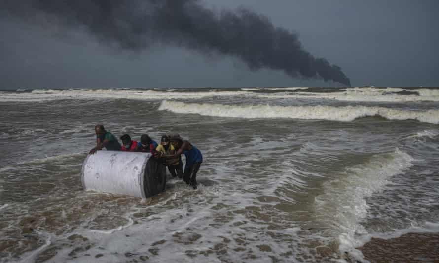
Establishing itself as a maritime centre remains at the heart of Sri Lanka’s geopolitical ambitions. In the process, however, the country has become irreversibly indebted. In 2010, it used loans from China to build Hambantota port. In 2017, the Sri Lankan government defaulted on its loans and a majority stake in the port was leased to China for 99 years. I cried as I watched the blazing fire, because of what it meant for my country and its stunning beaches and biodiversity
Despite heavy competition with larger ports in India, a Chinese-funded port city is being constructed in Colombo, Sri Lanka’s commercial capital. China’s substantial investments in Sri Lanka’s maritime provinces started a regional bidding war for control over the remaining container terminals in Colombo. China already owns 85% of the Colombo international container terminal; now Sri Lanka is negotiating with Japan and India over control of the east and west container terminals.
With the country carrying desperate levels of debt, and under extreme pressure to not only make a profit from the maritime industry but to also prove it has capable commercial shipping ports, it is not surprising that when a cargo ship approached Colombo port in May, and asked for permission to repair a dangerous chemical leak, the port authority obliged.
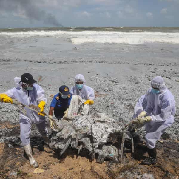
Sri Lanka navy personnel clear debris from the X-Press Pearl, which had 25 tonnes of nitric acid and other chemicals onboard. Photograph: Chamila Karunarathne/EPA
According to a statement from the harbour master, Nirmal Silva, the ship – the Singapore-registered X-Press Pearl – gave the port a general notice on its arrival, then at anchor sought permission to repair the leak.
“Such reworking activities are not uncommon in the port of Colombo,” Silva stated. “This is normal, especially in a hub port such as the port of Colombo. It is a service not only in our port but also in other ports in general. We must be ready to provide all these services available in the shipping industry as a trans-shipment hub.”
Several other countries, however, felt no such pressure to handle the compromised cargo. Media outlets reported that the ship was denied entry at ports in Qatar and India prior to arriving in Sri Lanka. This was later denied in an official statement by X-Press Feeders, the company that owned the ship. Instead, the company indicated that these ports had not accepted the leaking cargo.
“Applications had been made to both ports to offload a container that was leaking nitric acid but the advice given was there were no specialist facilities or expertise immediately available to deal with the leaking acid,” the statement said.
Meanwhile, AFP News reported that the ship had told its local shipping agent of an acid leak onboard the vessel, but the agent had failed to alert local authorities.
The leak is thought to have caused a fire that has led to the worst maritime disaster in Sri Lanka’s history: a cargo ship filled with dangerous chemicals burning and sinking just off the island’s western coast. The country is facing an oil leak that could devastate the fishing industry and coastal environment, as well as the threat of the dozens of highly toxic chemicals on board, some of which have yet to be catalogued, let alone recovered.
From thousands of miles away in New York, I cried as I watched the blazing fire, because of what it meant for my country’s economy and its most valuable assets: its stunning beaches and unparalleled biodiversity. I felt dread at the prospect of losing more ground to powerful countries in a geopolitical tug-of-war if this puts more pressure on Sri Lanka’s ailing economy. Hopefully, the failures in oversight and accountability will serve as a vital learning experience and spur long-overdue environmental safeguards to prevent a repetition of this disaster.
But the disaster also harmed our collective dream of what we should be as a country. Desperate to prove ourselves at any cost in the service of our self-identity – and with the vast debt that we have incurred to secure that identity – Sri Lanka has been handed a bill for more than just the clean-up. It has suffered a blow to its reputation as an emerging maritime hub.
Whether this disaster will also be the moment when Sri Lanka stops shackling itself with unpayable debts and teaches a different vision to its children – one that accepts that Sri Lanka is not Singapore, but a country that embraces the ocean’s wonders rather than treating it like a dumping ground – time will tell.
Michael Packard, a lobster diver in Provincetown, Mass., found
himself inside the mouth of a whale on Friday morning, then was spit
out.
It was sunny and clear on Friday morning and the water was calm off the coast of Provincetown, Mass., where Michael Packard was diving for lobsters.
His longtime fishing partner, Josiah Mayo, was following him in their fishing vessel, the J&J, tracking him through the bubbles that rose from Mr. Packard’s breathing gear to the surface of the water.
The men had already caught 100 pounds of lobster, and Mr. Packard was about 40 feet underwater, looking for more.
Suddenly, the bubbles stopped, Mr. Mayo said. Then, the water began to churn violently. A creature breached the surface and for an agonizing split second, Mr. Mayo thought it was a white shark.
“I immediately thought it was the shark encounter that we’d unfortunately been preparing for for years,” he said in an interview on Saturday.
Then, he saw the fluke and the head of a whale. Moments later, he saw Mr.Packard fly out of the water.
“‘It tried to eat me,’” Mr. Packard sputtered, according to Mr.Mayo. The whale, a humpback, swam away as Mr. Mayo and another fisherman helped Mr. Packard back into the boat.
Mr. Packard, center, and Josiah Mayo after bringing in a tuna in October.
Mr. Mayo was aboard the J&J when he saw a humpback whale breach and spit out his longtime fishing partner.
Credit...Edward Boches
Such terrifying encounters are virtually unheard-of, according to Charles Mayo, Josiah Mayo’s father and a senior scientist at the Center for Coastal Studies in Provincetown, a town of about 3,000 people on the tip of Cape Cod. There is an account of a woman who was pulled down by a pilot whale. There are reports of sperm whales that went on the offensive after being harpooned. And in 1896, The New York Times reported the implausible tale of a whaler who was found in the belly of a whale in October 1891 and rescued alive.
“I’ve never heard of that ever happening,” Dr. Mayo said of Mr. Packard’s ordeal. Still, the encounter is explainable, he said.
The whale, possibly a 32- to 35-foot juvenile that had previously been seen swimming in the area, was most likely diving for food when it inadvertently caught Mr. Packard in its enormous mouth.
Humpback whales spend much of their time in that part of New England, searching for and engulfing small schooling fish, said Jooke Robbins, director of the humpback whale studies program at the Center for Coastal Studies.
They lunge fast, open their mouths and use baleen plates to “filter” the water out before swallowing the fish, Dr.Robbins said in a statement.
When the whale realized it had caught something that was not its typical prey — in this case, an unsuspecting lobsterman — it responded the way a human who accidentally ingested a fly would, Dr. Mayo said.
“We certainly don’t eat any more,” he said. “We spit the food out, and some of us would leave the restaurant.”
His first thought was that a white shark had attacked him, but when he did not feel teeth piercing into him, he realized he was inside a whale.
“I was completely inside; it was completely black,” Mr. Packard told The Cape Cod Times. “I thought to myself: There’s no way I’m getting out of here — I’m done, I’m dead. All I could think of was my boys — they’re 12 and 15 years old.”
Mr. Packard said he was in the mouth for at least 30 seconds, wondering whether he would run out of air or be swallowed. He said he struggled against the mouth of the whale and could feel its powerful muscles squeezing against him. Then, he saw light and felt the whale’s head shaking and his body being thrown into the water.
Mr. Mayo said he called 911 and an ambulance met them at the dock. He then called Mr. Packard’s wife. “‘Hi, Mike is OK,’” Mr. Mayo recalled telling her. “You’ve got to lead with that.”
Mr. Packard, who was released from the hospital on Friday, had extensive bruises, but no broken bones.
On Friday afternoon, he wrote a cheerful note on a Provincetown community Facebook page, thanking the Provincetown rescue squad for helping him. “I was lobster diving and a humpback whale tried to eat me,” he wrote. “I was in his closed mouth for about 30 to 40 seconds before he rose to the surface and spit me out. I am very bruised up but have no broken bones.”
Mr. Mayo said he initially thought Mr. Packard had broken his leg. As scared as he was for his friend, he said he felt a little relief that the season might be over.
But once he learned that Mr. Packard had not sustained any broken bones, Mr. Mayo said he knew the two of them would head out again soon.
Mr. Packard promised the same to reporters.
He said, “As soon as I heal up, I’ll be back in the water.”
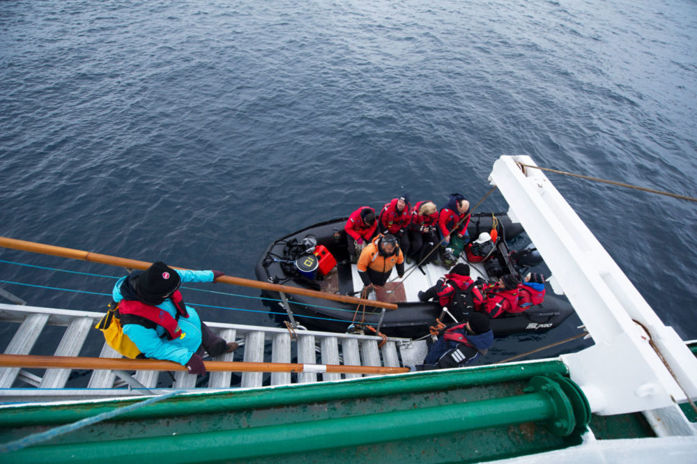
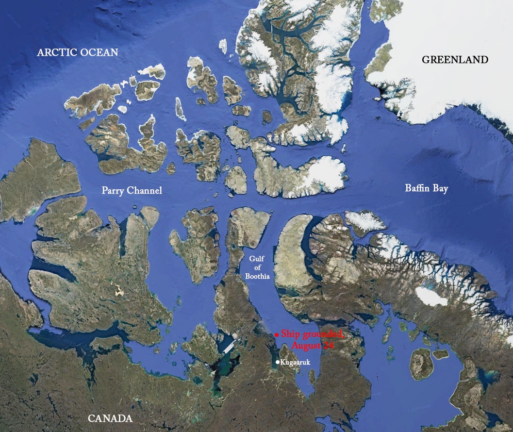
On August 24, 2018, the Russian passenger vessel Akademik Ioffe ran aground with a shudder as it sailed through narrows in the Canadian Arctic. I was aboard when the accident occurred in the remote Gulf of Boothia, an area not surveyed to adequate hydrographic standards and where none of the vessel’s crew had ever been before.
On board were 24 of us on a U.S. National Science Foundation-sponsored expedition, as well as 102 tourists and 37 crew members. We knew the ship was in trouble, but we had no idea how bad things actually were until the Transportation Safety Board of Canada released a report two weeks ago. Among other findings, the report says that the Russian crew had turned off the low-water depth alarms; that the captain immediately used the engines to try to refloat the vessel, a decision that went against standard practices because using propulsion could further open up a gashed hull; and that the ship’s officers wrongly informed passengers that the hull had not been breached and that the ship was not leaking oil.
Coming on the heels of the near-sinking of a Dutch ship carrying 350 tons of heavy oil in the Norwegian Sea last April, and 74 groundings that occurred in the Canadian Arctic from 2000 to 2018, the report underscores in chilling ways how a steady increase in shipping in a rapidly melting and largely uncharted Arctic could result in an environmental and human disaster.
“Until the coastal waters surrounding the Canadian Arctic Archipelago are adequately charted, and if alternate mitigation measures are not put in place, there is a persistent risk that vessels will make unforeseen contact with the sea bottom, putting passengers, crew, and the environment at risk,” the Transportation Safety Board investigators warned.
Passengers evacuating the Akademik Ioffe, on August 25, 2018, the day after it ran aground.
That warning could easily apply to the entire Arctic. As shipping in this previously icebound region increases, maritime experts say, at the top of the list of concerns is the need for global and national standards requiring certified ice navigators — trained and experienced in the maneuvering of vessels in ice-covered waters — aboard all ships.
Added to that concern is the paucity of accurate navigational charts, which have yet to be made in many Arctic waters because of cost and the fact that sea ice conditions made it difficult to map the Arctic Ocean bottom until the last couple of decades. Experts say these dual threats mean that the expected boom in Arctic shipping could well lead to maritime and environmental disasters.
So far, shipping in the Arctic has increased modestly in tandem with sea ice retreat. According to the Arctic Council, the leading governmental forum promoting cooperation in the Arctic, ship traffic in the region grew by 25 percent between 2013 and 2019, from 1,298 ships to 1,628 ships. The total distance sailed by those ships grew by 75 percent in that same period, from 6.51 million nautical miles to 9.5 million nautical miles.
But economists and Arctic experts expect ship traffic to steadily accelerate with further melting and the rapid expansion of the world’s ice fleet. Russia has more than 50 icebreakers and is building ports and encouraging shipping companies to use the Northeast Passage across the top of Siberia as a shortcut connecting the North Atlantic to the Pacific. China, which has already explored all three polar routes — the Northwest Passage across Alaska and Canada, as well as the Northeast Passage and the Transpolar Route over the North Pole — recently announced plans to launch a satellite to monitor Arctic shipping routes. The cruise ship, Crystal Serenity, sailed through the Northwest Passage in 2017 with 1,000 people aboard, a harbinger of the future growth of such tourism voyages.
Less ice actually brings greater hazards as the volume of shipping increases.
It’s dangerous enough for ships to be sailing in a region like Arctic Canada and Alaska, where only 14 per cent and 4.1 percent, respectively, of the ocean has been surveyed to modern standards. No ports exist in either northern Alaska or Arctic Canada from which a rescue could be staged or an oil spill cleaned up.
The East Siberian Sea, which is the shallowest of the seas along the Northern Sea Route and notorious for extreme temperatures and dangerous ice conditions, is even more perilous. A 2018 study found that it has the highest risk in the Arctic for ship collisions, the sinking of ships, and ships running aground. According to a recent report by the U.S. National Geospatial Intelligence Agency, “it is not possible to ensure that [nautical] charts and publications, covering the coasts of Russia and adjacent waters, are up to date concerning new dangers.”
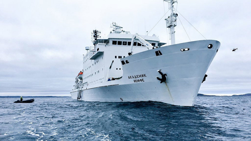
The Akademik Ioffe after running aground on a shoal in the Canadian Arctic on August 24.
Donglai Gong
Maritime experts say that contrary to what many academics assert, the decline of sea ice is making shipping more dangerous, especially in areas like the Norwegian Sea — between Scandinavia and Greenland — where cruise ships, fishing boats and other vessels are stretching operational seasons and expanding navigation areas.
“Arctic shipping will not get safer as the ice diminishes,” said John Falkingham, secretariat of the International Ice Charting Working Group, which promotes coordination of sea ice and iceberg-information services. “Since we first recognized the decline of sea ice, the watchword of Arctic mariners and ice experts was that less ice actually brings greater hazards to shipping.”
The Canadian Arctic region where the Akademik Ioffe ran aground.
Satellite observations show that the extent of Arctic summer sea ice has shrunk by roughly 40 percent since 1979, and that the volume of sea ice — based on thickness — has fallen by roughly two-thirds. But the remaining ice, Falkingham said, is more mobile, allowing it to drift on wind and current. This can create extreme pressure zones at port entrances, straits or passages, where ships have little room to maneuver and avoid ice that could damage or hole a ship.
“In high seas,” he added, “small multiyear ice floes can be thrown around, damaging anything they come in contact with — including ships.”
And it’s not just sea ice that presents a hazard, he said: “The ice caps are retreating across the Arctic, dropping more and more icebergs into the ocean. The big, picturesque ones are not a problem for ships — but as they melt in the sea and become smaller and lower … they are a major hazard — hard as concrete and weighing tens of thousands of kilograms. A ship coming in contact with one can easily be critically damaged.”
The term “ice-free,” according to Falkingham, is a misnomer.
“In the navigation world, ice-free means just that — no ice at all,” he said. “But in the academic world, `ice-free’ typically means less than 15 percent ice concentration because the microwave satellite sensors used to monitor Arctic Ocean ice do not detect ice amounts lower than about 15 percent. So the satellite doesn’t see it, and the scientist says it’s ice-free. But if the navigator who charges ahead unknowingly is unlucky enough to hit a bit of the 15 percent, there could be a bad result.”
The good news is that the Arctic has not yet become the highway that some have predicted. Shipping is increasing incrementally, and in most cases, with some degree of planning. Most of these dangers can be avoided if there is an experienced ice navigator on board, as is recommended by the International Marine Organization (IMO) Polar Code. The problem with the required Polar Water Certificate, according to David Snider, CEO of Martech Polar Consulting and a master mariner with 40 years’ experience sailing in polar regions, is that it falls short of the Nautical Institute’s ice navigator training requirements, the global gold standard in certification for polar navigation. Valid Polar Waters certificates, which typically require several days of classroom time and ship simulator instruction at world-class facilities, can now be inexpensively secured with less classroom and simulator time from schools in places like the Bahamas.
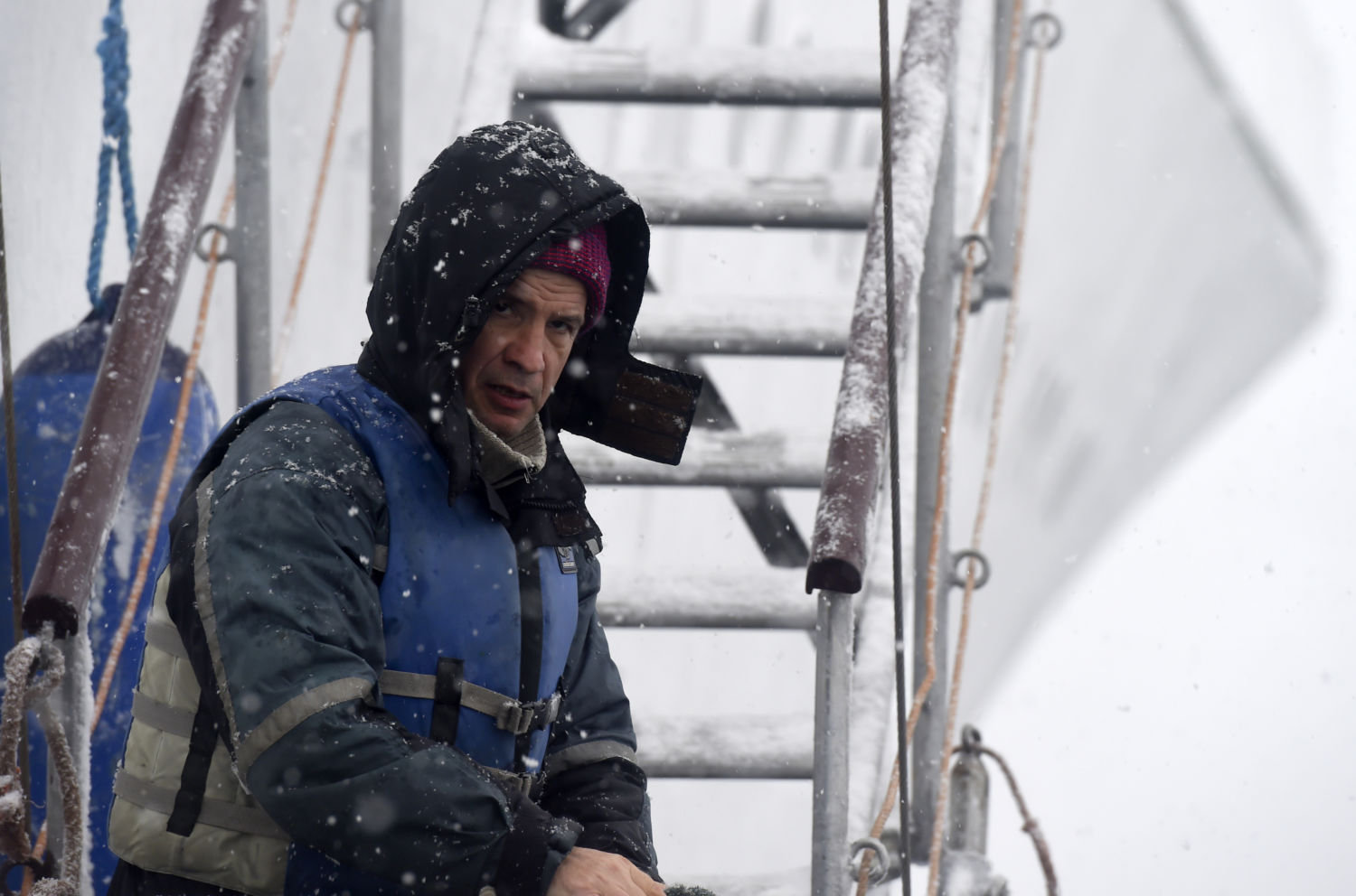
A Russian crew member aboard the Akademik Ioffe in 2016
Eitan Abramovich / AFP via Getty Images
“A Polar Waters certificate can be obtained by a person who has never navigated through ice,” Snider said. What’s needed, he added, is to tighten up the Polar Code, and failing that, “coastal states like Canada and the United States could simply change regulations requiring ships to have an experienced ice navigator on board.”
The grounding of the Akademik Ioffe underscores how inexperience and human error in the Arctic — issues not often discussed in the media since the Exxon Valdez spilled oil in Alaska’s Prince William Sound in 1989 — contributed to the 2018 emergency.
Russian crew members, according to the report, were “not closely monitoring the echo sounders, and the steady decrease of the under-keel water depth went unnoticed for more than four minutes, because the echo sounders’ low-water-depth alarms had been turned off.” When the ship’s officers realized the vessel was going to grind to a stop on the shoal, it was too late. The Canadian report says the hull was breached in four places, flooding two fuel tanks and two ballast tanks.
The grounding also highlights how some shipping companies do not necessarily adhere to recognized seamanship practices. Following a grounding, according to the report, attempts to refloat a vessel using the engines should only be made if the vessel is in immediate danger of sustaining a catastrophic structural failure, or if a breach in the hull is worsening. Otherwise, attempting to refloat a vessel using propulsion can further damage a ship’s structure.
‘The more vessels there are, the greater the risks of air pollution and oil slicks and spills,’ said an expert.
But the checklist for the Akademik Ioffe stipulated that the captain must attempt to refloat the vessel with its engines. The captain, who had sailed several times in the Arctic and Antarctic, did this before inspecting the underwater hull, activating the general alarm, or broadcasting a distress message. Confusion, and in some cases panic, set in when the captain ignored requests to address the passengers directly, as is customary in an emergency.
In addition, a ship’s officer wrongly informed the expedition leader that the hull had not been breached and that no fuel had spilled, when it was obvious to those on board — from the sheen spreading across the water — that oil was leaking. The report says the crew did not immediately call for assistance for an oil spill cleanup, rescue, or tow, as is typically done. When the captain did call an hour after the grounding, the nearest available Canadian military Hercules aircraft was nine hours away. Two Canadian Coast Guard vessels were 22 and 36 hours distant. The nearest vessel was a Russian sister ship that had a full load of passengers and not enough safety gear for more than 100 additional passengers. The vessel took 18 hours to get there.
If the Ioffe had begun to sink, the distant location of rescue vessels could have been disastrous.
Such problems could be magnified many times if large numbers of ships begin to transit the Arctic. The Northeast and Northwest passages are already open for part of the summer. And University of Hong Kong geographer Mia Bennet and colleagues recently published a study suggesting that a northern sea route directly over the North Pole could become navigable by mid-century.
“More ice-class vessels are being built — often in Chinese shipyards — to support gas development on the Yamal Peninsula [in Siberia] and resource extraction in northern Canada and Greenland,” Bennet said. “The more vessels there are, the greater the risks of air pollution and oil slicks and spills.” In addition, she said, ice-breaking vessels could damage the ice on which many Arctic species rely, from walruses to polar bears. Indigenous peoples, especially in the Bering Strait, still depend on many of these animals for subsistence.
Since it was established five years ago, the Clean Arctic Alliance, a coalition of 22 environmental organizations, has been pushing for a ban on shipping companies burning heavy fuel oil, which is viscous, inexpensive and dirty, as nations that are party to the Antarctic Treaty did a decade ago. Switching to lighter, cleaner-burning fuel or liquified natural gas is more costly, but less likely to cause an environmental disaster.
“If heavy oil spills into cold Arctic waters, it will likely break down very slowly and prove to be almost impossible to clean up,” said Sian Prior, the lead advisor for the alliance. She noted that heavy fuel oil also produces a considerable amount of black carbon, which contributes to climate warming, and that black carbon emissions from shipping increased by 85 percent from 2015 to 2019.
Some progress is being made. Norway recently banned the use of heavy oil fuel in some waters around the Arctic archipelago of Svalbard. The International Maritime Organization also has announced a ban on the use and transportation of heavy fuel oil in the Arctic that will take full effect by 2030.
Falkingham is currently organizing an international conference that will bring the world’s national ice services together again to coordinate activities to help make polar shipping safer.
As a testament to how little we know about the Arctic, as recently as 2003 the U.S. Coast Guard cutter, Healy, discovered an 6,561-foot seamount, or underwater mountain, north of Alaska. As the Arctic opens to more ships, how many more seamounts and shoals are to be discovered — either benignly, as with the Healy, or less so, as with the grounding of the Akademik Ioffe?


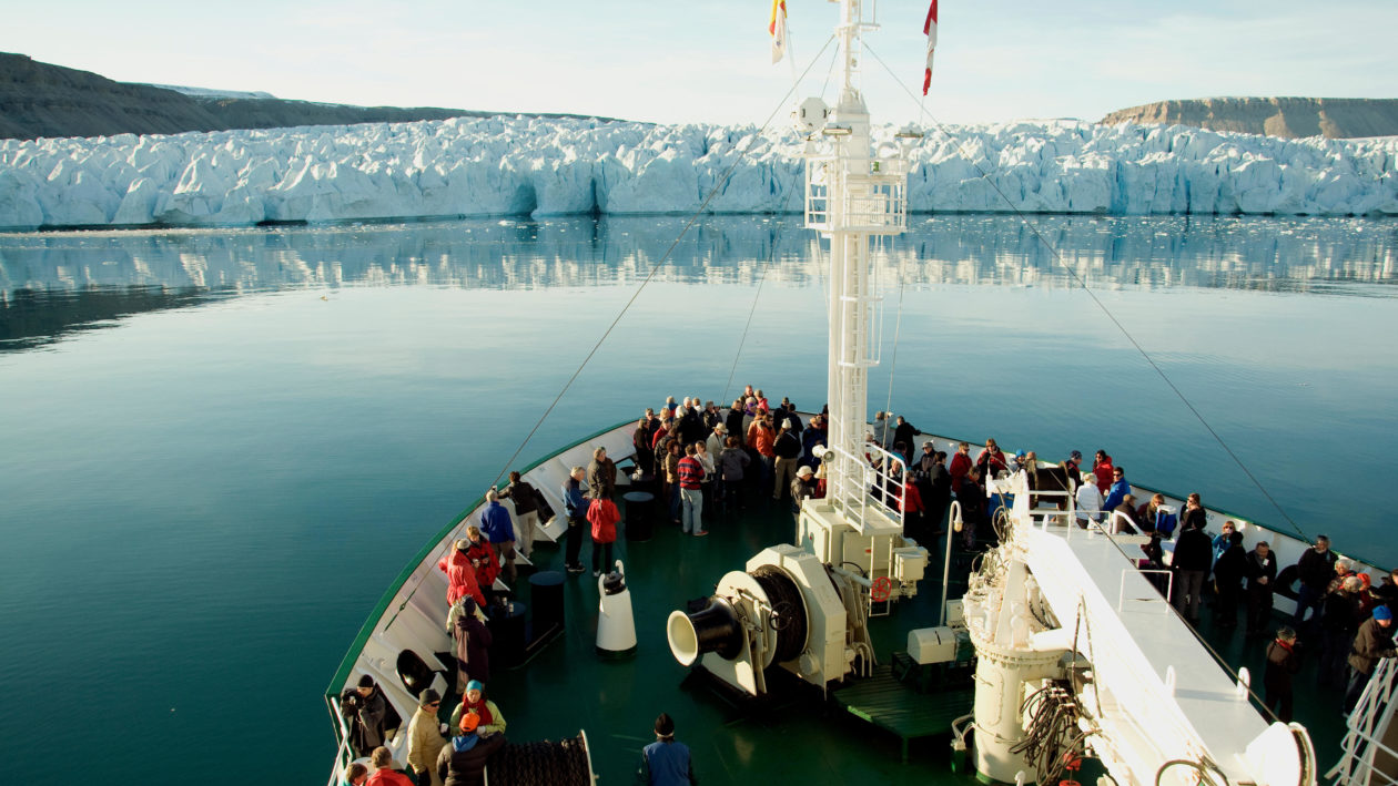
 Exiles, whose crew collected data on fjords in the Arctic, anchors near a receding glacier in 2017.
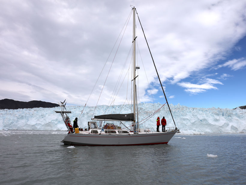 Exiles sails past the Eqi Glacier in Greenland.


