Saturday, July 2, 2022

Visualizing the impact of rising sea levels, by country

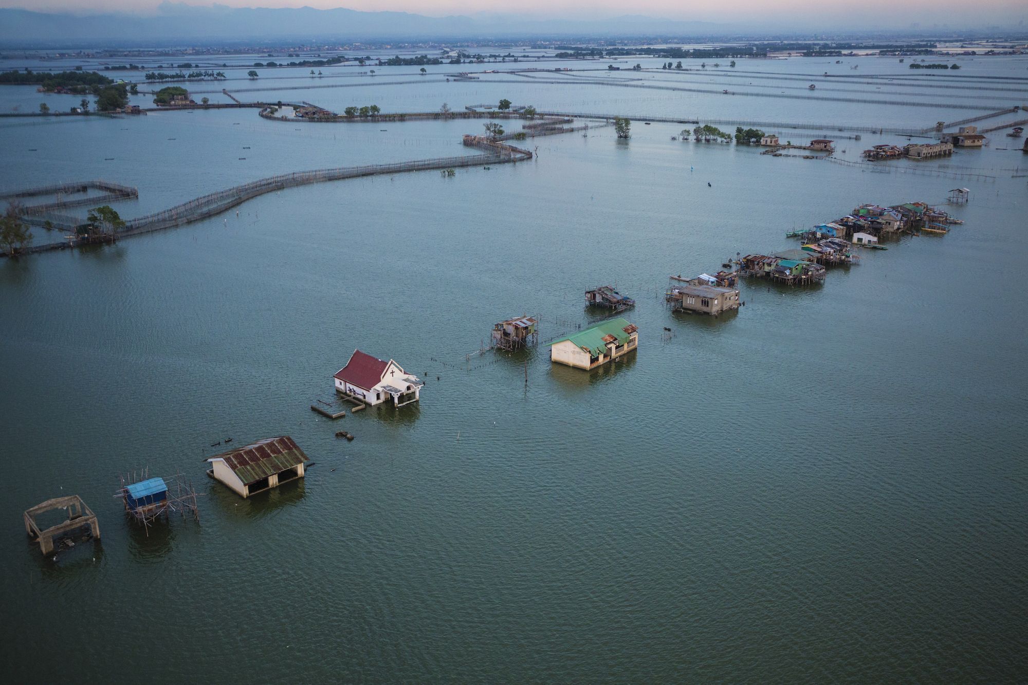
photo George SteinMetz (National Geographic)
 
From Visual Capitalist by Florent Lavergne

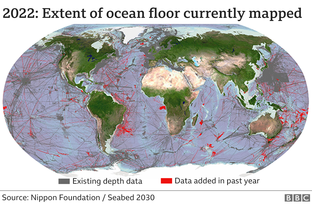
Climate change is already causing sea levels to rise across the globe. In the 20th century alone, it’s estimated that the mean global sea level rose by 11-16 cm.

How much will sea levels change in the coming years, and how will it affect our population?

In the below series of visualizations by Florent Lavergne, we can see how rising sea levels could impact countries in terms of flood risk by the year 2100.

These graphics use data from a 2019 study by Scott Kulp and Benjamin Strauss.
Their study used CoastalDEM—a 3D graphics tool used to measure a population’s potential exposure to extreme coastal water levels—and examined rising sea levels under different levels of greenhouse gas (GHG) emissions.

Flood Risk By Region

Which countries will be most severely affected by rising sea levels?

If things continue as they are, roughly 360 million people around the world could be at risk of annual flood events by 2100. Here’s what those figures look like across each region:
Africa


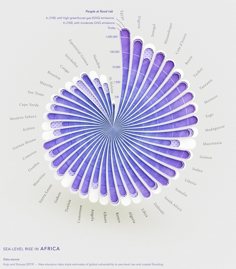
On the continent of Africa, one of the countries with the highest number of people at risk of coastal flooding is Egypt.

Over 95% of Egypt’s population lives along the Nile river, with some areas situated at extremely low elevations. The country’s lowest point is 133 m below sea level.

Asia


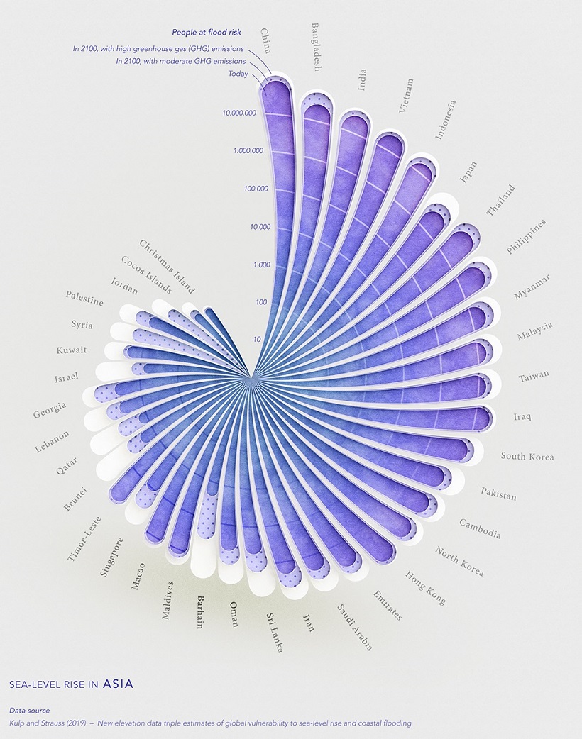
Asia’s population will be more heavily impacted by flooding than any other region included in the dataset.

According to the projections, 70% of the people that will be affected by rising sea levels are located in just eight Asian countries: China, Bangladesh, India, Vietnam, Indonesia, Thailand, the Philippines, and Japan.

Europe


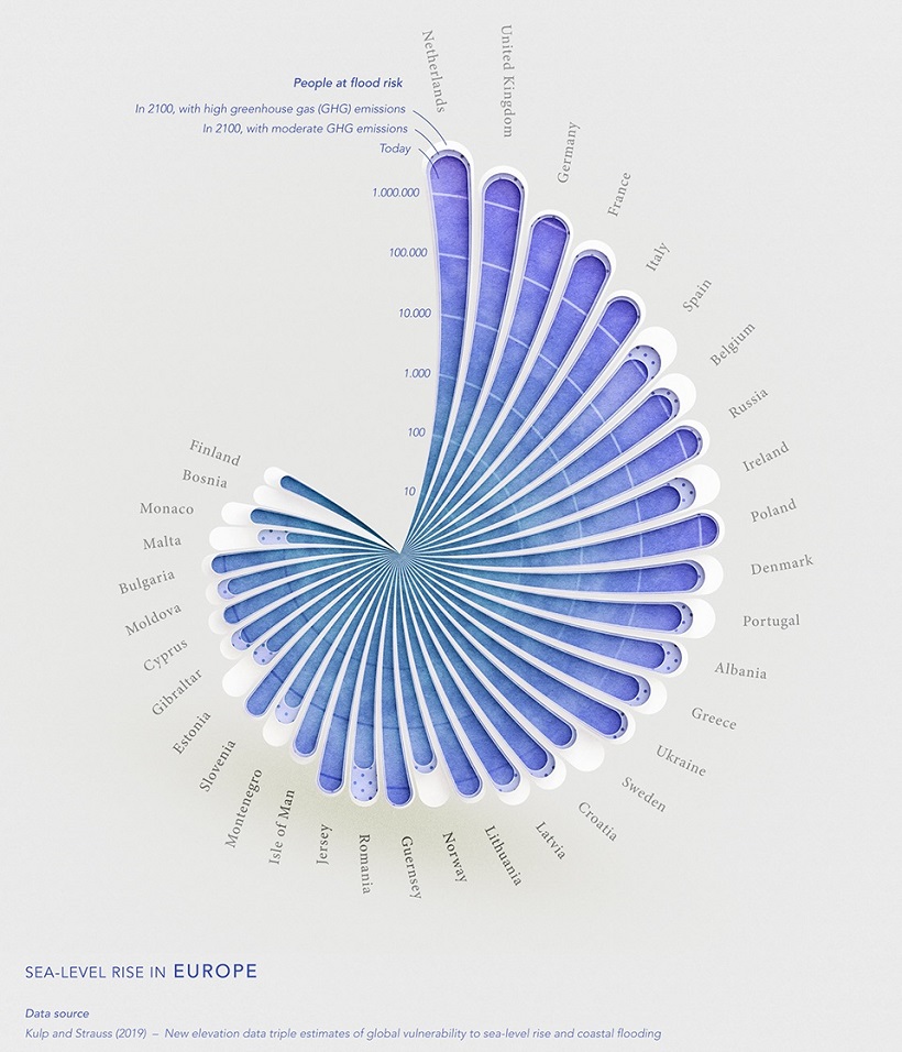
One of the most high-risk populations in Europe is the Netherlands.
The country has a population of about 17 million, and as of 2019, about half of its population lives in areas below sea level.

The country’s lowest point, the town Nieuwekerk aan den Ijssel, is 6.8 m below sea level.
North America


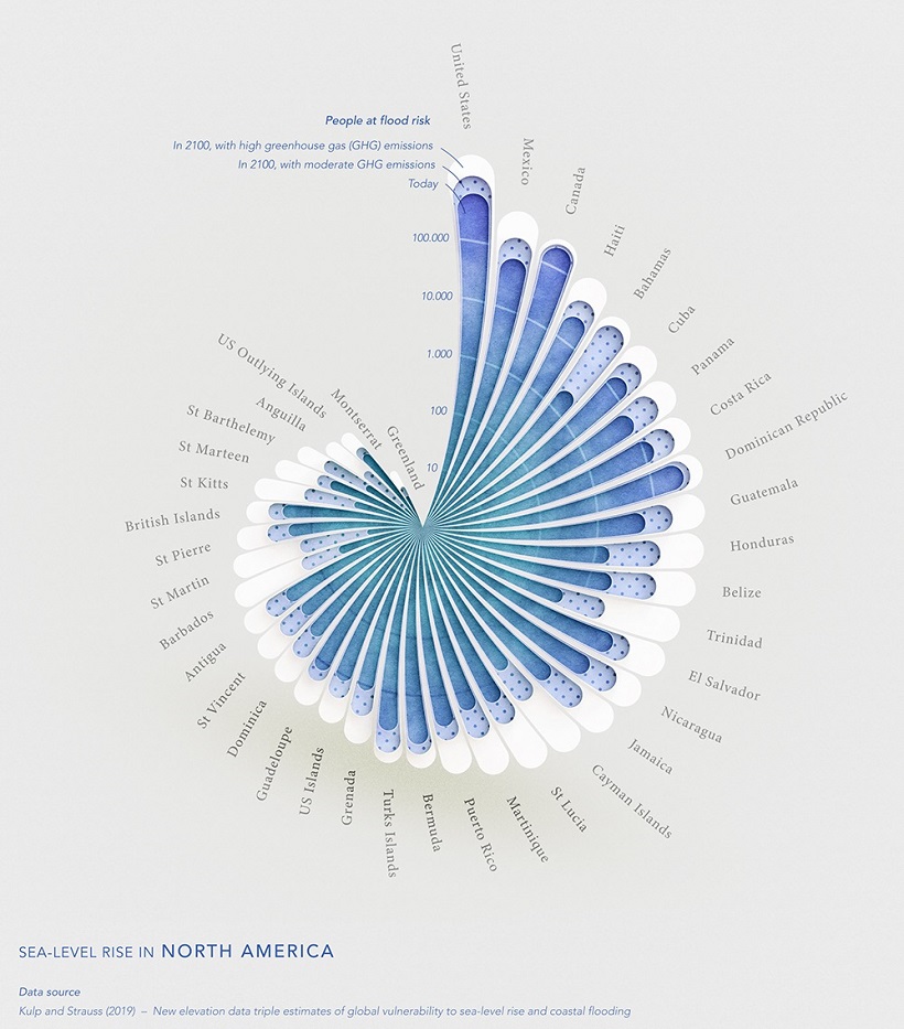
In North America, the U.S., Canada, and Mexico are expected to see the highest numbers of impacted people, due to the size of their populations.

But as a percentage of population, other countries in Central America and the Caribbean are more greatly at risk, especially in high emission scenarios.
One country worth highlighting is the Bahamas. Even based on moderate emission levels, the country is expected to see a significant surge in the number of people at risk of flood.

According to the World Bank, this is because land in the Bahamas is relatively flat, making the island especially vulnerable to sea level rises and flooding.

South America


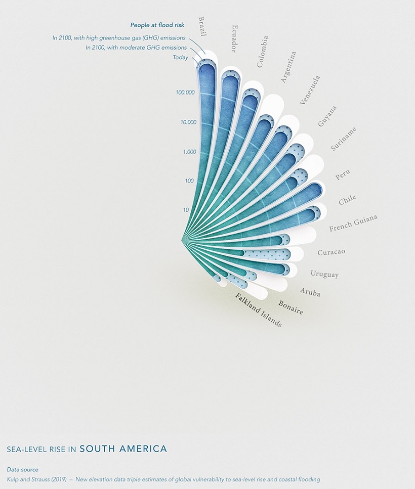
As South America’s largest country by population and with large coastal cities, Brazil‘s population is the most at risk for flood caused by rising sea levels.

Notably, thanks to a lot of mountainous terrain and municipalities situated on high elevation, no country in South America faces a flood risk impacting more than 1 million people.

Oceania


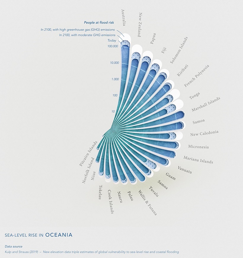
By 2100, Polynesian countries like Tonga are projected to see massive increases in the number of people at risk of flooding, even at moderate GHG emissions.

According to Reuters, sea levels in Tonga have been rising by 6 mm each year, which is nearly double the average global rate.
The reason for this is because the islands sit in warmer waters, where sea level changes are more noticeable than at the poles.

What’s Causing Sea Levels to Rise?

Since 1975, average temperatures around the world have risen 0.15 to 0.20°C each decade, according to research by NASA.

This global heating has caused polar ice caps to begin melting—in just over two decades, we’ve lost roughly 28 trillion tonnes of our world’s ice.
Over that same timeframe, global sea levels have risen by an average of 36 mm.
These rising sea levels pose a number of risks, including soil contamination, loss of habitat, and flooding.

As countries are affected by climate change in different ways, and at different levels, the question becomes how they will respond in turn.

Friday, July 1, 2022

Nearly a quarter of Earth's seafloor now mapped


The oceans cover 70% of the Earth's surface.
Of that area, 23.4% is now mapped to modern standards


From BBC by Jonathan Amos

Slowly but surely the proportion of the global ocean floor that's been properly mapped is rising.

It's now up to just shy of a quarter of the total area under water - at 23.4%.

Better seafloor maps help us with navigation and conservation, among many other uses.

Some 10 million sq km (3.8 million sq miles) of new bathymetric (depth) data was added in the past year.
This is an area broadly equivalent to the land surface of Europe.

The update was given at the second UN Ocean Conference, taking place this week in Lisbon, Portugal.

Much of this additional data comes not from recent mapping efforts, however, but simply as a result of governments, institutions and companies agreeing to open up their archives.

It's thought a further 10-15% is still squirrelled away on servers, in part because the owners worry they might be giving away commercial or defence secrets if they release the information.
"But they really needn't worry," said Jamie McMichael-Phillips, director of Seabed 2030, the organisation that is trying to corral world efforts to obtain a complete picture of Earth's ocean bottom.
"One of the messages we're trying to get across is that we don't require high-resolution data. Hi-res is nice; we can work with it. But lower resolution is perfectly acceptable.
"One depth value in an area the size of a European football pitch, 100m by 100m or thereabouts, isn't going to give away national or commercial secrets."


Saildrone Surveyor's cruise to Hawaii from San Francisco added 22,000 sq km of depth data

This knowledge is needed for a host of reasons.

Sea maps are essential for safe navigation, obviously, but also for fisheries management and conservation.
Marine wildlife tends to congregate around the underwater mountains.
Each seamount is a biodiversity hotspot.

In addition, the rugged seafloor influences the behaviour of ocean currents and the vertical mixing of water.
This is information required to improve the models that forecast future climate change - because it is the oceans that play a pivotal role in moving heat around the planet.

At the moment, our knowledge of just over three-quarters of the planet's underwater terrain comes only from low-resolution satellite measurements that have inferred the presence of tall seamounts and deep valleys from the gravitational influence these features have on the sea surface.
Water piles up over the mass of a large submarine mountain and dips slightly where there is a trench.

It's super smart but an underwater mountain that's hundreds of metres tall can still fail to show up in such observations.


2nd tallest underwater mountain in all of Canada & we mapped it for the first time ever just yesterday


Seabed 2030, which is funded by Japan's Nippon Foundation, is encouraging anyone who ventures away from the land to switch on their sonar equipment and take depth soundings.
And this isn't just about measurements from big ships; small ocean-going yachts fitted with data loggers can also make a contribution.

One of Seabed 2030's stars is the American adventurer Victor Vescovo.
The Texan financier is using a submersible to visit the deepest places in the world's oceans, but everywhere he goes his support ship switches on its echosounder.
"We have a 'map the gap' strategy," Mr Vescovo told BBC News.
"We're not a commercial outfit so we don't have to follow the most fuel-efficient routes.
When we go on an expedition we ask [Seabed 2030], 'what are your priority areas?'; and we divert a little bit to cover those areas."

The former US Navy reservist has himself contributed over 3 million sq km.


Ocean Infinity is building enormous robot vessels

It's clear, however, that to come close to obtaining a full picture of the shape of Earth's ocean bottom, there will need to be a step change in approach and capability.
Many parts of the world are so remote, few ships will visit them, let alone acquire depth data in those regions.

To map these places is going to require direct tasking of autonomous or semi-autonomous technologies.

There is a glimpse of how this will work in one line of data featured in the map at the top of this page.
It was gathered by the Saildrone Surveyor on a cruise between San Francisco and Honolulu last year.

During this 28-day voyage, the robot boat mapped 22,000 sq km of seafloor.
Saildrone Surveyor is 22m in length.
But truly huge autonomous vessels are coming.

The marine robotics company Ocean Infinity is currently building a fleet of 78m-long ships in Vietnam.
Regulations will probably mean they have to be lean-crewed for the near future, but the goal eventually is to have them roving the ocean without anyone onboard.
Their work would be overseen from satellite-linked control centres in the UK, the US and a third location somewhere in Asia.

Such ships could be sent out on long missions to map hard to reach areas at much lower cost than would be incurred by a conventional crewed vessel.


Progress to full mapping of the seafloor was discussed in a side meeting at this week's UN Ocean Conference.
And while the participants recognised new technologies were essential to fulfilling the quest, Dr Lucy Woodall cautioned that the 2030 project would fail unless it engaged all communities with an interest in the data.

She cited examples of companies going into coastal areas to map the seafloor and then not sharing any of the information with the local people whose livelihoods depended on those waters.

"I would argue to those of you in the room who think technology has got to be the way - I would argue that, actually, people are the way because unless people are asking the questions, unless we have a dialogue with all the voices in the room, then we're not going to ask, and therefore we can't answer, those right questions," the chief scientist with Nekton, a UK-based oceans NGO, told the meeting.
 
Links :

Thursday, June 30, 2022

Where to draw the line in the Eastern Mediterranean


The deck of a French aircraft carrier sails off the eastern coast of Cyprus on Feb.
10, 2020.
Mario Goldman / AFP/ Getty images


From ForeignPolicy by Michaƫl Tanchum
 
As France sends aircraft carriers to the region, all sides should look to Bangladesh and Myanmar for a solution to the border dispute.

Turkey and Greece’s escalating Eastern Mediterranean conflict, based on an old maritime boundary dispute, is becoming a geopolitical nightmare for NATO and the European Union.
On Feb. 21, France sent its nuclear aircraft carrier to operate for several months in the Eastern Mediterranean as a show of force in support of Greece.
Athens, disappointed with many of its other EU partners’ conciliatory approach to Turkey, has mobilized an unprecedented level of military support from Egypt, Israel, Saudi Arabia, and the United Arab Emirates.
A defiant Turkey, which maintains 30,000 troops in the northern part of ethnically divided Cyprus, now insists the EU member nation be partitioned to create an independent Turkic state.

The conflict is tearing at the fabric of Europe and eroding NATO solidarity.
Brussels and Washington need to draw the line with Ankara and Athens on their maritime boundary dispute before it is too late.
But where?

 Greece-Turkey EEZ with the GeoGarage platform
 
At issue for Turkey is the EU-recognized Seville map’s maritime boundaries of the Eastern Mediterranean.
Named after an EU-commissioned map study by the University of Seville, it drew maximal boundaries for Greece and Cyprus at Turkey’s expense by using the coast of every inhabited Greek island no matter how small and no matter how close to the Turkish coastline.
Particularly contentious was the Seville map’s use of Kastellorizo, a very small island just one mile from the Turkish coast, in defining the Greece-Turkey maritime boundary.

The Seville map followed the United Nations Convention on the Law of the Sea’s (UNCLOS) Article 121, which maintains that the coastline of an island that can “sustain human habitation or economic life” generates a continental shelf and an exclusive economic zone (EEZ), the same as any coastal land formation.
Yet at the same time, UNCLOS also provides for a principle of equity, and the international case law based on it creates the possibility of setting aside Article 121 when its application creates an unjustifiable encroachment on the maritime zone of a mainland coast.
Ankara has never explored this avenue for adjusting the Seville map since it is not a signatory to the convention.

Turkey instead found an international partner with which to draw its own map.
In 2019, Ankara signed a maritime agreement with war-torn Libya’s Tripoli-based government, which created a map that defines a maximal maritime zone for Turkey by denying any of Greece’s islands a continental shelf or an EEZ.
The agreement demarcates just an 18.6-nautical-mile segment of the maritime boundary between Turkey and Libya.
However, projecting out from that strip, the Ankara-Tripoli map divides the entire maritime zone exclusively between Turkey and Libya.
Turkey’s map would be invalid under any circumstance since the 3,219-square-mile Greek island of Crete in the middle of that maritime zone would unquestionably generate an EEZ for Greece.

The impasse over these two maps has turned the Eastern Mediterranean into the eye of a geopolitical storm.
Ankara and Athens both need to step back from their maximal demands.
If they do, progress on the maritime boundary dispute could jump-start the stalled negotiations on a Cyprus reunification plan.
If they don’t, the escalating crisis could engulf the region.

To understand how the borders could be drawn, the sides should look to the resolution of an analogous dispute between Bangladesh and Myanmar.

To understand how the borders could be drawn, the sides should look to the resolution of an analogous maritime dispute between the adjacent states of Bangladesh and Myanmar.
Although the Bay of Bengal may seem rather remote from the Eastern Mediterranean, both maritime regions are rich in offshore natural gas resources with similarly high geopolitical stakes.

The island of Kastellorizo, whose maritime jurisdiction is at the heart of the Turkey-Greece boundary dispute, has a very close analogue in the Bay of Bengal’s Saint Martin’s Island.
The 14-square-mile dot is home to 4,000 inhabitants and is Bangladesh’s southernmost point.
A tourist hotspot on account of its coral reef and beaches, the island also happens to lie five miles off Myanmar’s coast.
 
Saint Martin island with EEZ limitation and ENC viewing (BD307425) with the GeoGarage platform

As a piece of Bangladeshi territory located so close to Myanmar’s coast, Saint Martin’s Island exerted outsized influence on the maritime boundary line and severely boxed in Myanmar.

 Kastellorizo with ENC GR4APP07
 
ENC TR300321
 
Greece’s Kastellorizo is smaller than St. Martin’s and is located even closer to Turkey’s coast.
Popularized among tourists by the 1991 film Mediterraneo, the 3.6-square-mile island is home to no more than 500 people.
But the island has also been used to define the maritime boundary close to Turkey’s shores.

Unlike the Eastern Mediterranean antagonists, Bangladesh and Myanmar brought their dispute before the International Tribunal for the Law of the Sea.
Rendering its judgment in March 2012, the tribunal rejected Myanmar’s argument, which used a similar logic to Turkey’s map.
The tribunal held that Saint Martin’s Island was a proper inhabited island that could sustain economic life.
Meeting the UNCLOS Article 121 standard, the island would generate a continental shelf and EEZ and should be included in the calculations of Bangladesh’s borders.
But that was not the end of the tribunal’s decision.

Taking a page from Beijing, Rome is positioning itself as the center of trade, energy, and transportation in Southern Europe and beyond.


Turkey’s adventures abroad are about more than hydrocarbons.
They’re a bold and expensive attempt at geopolitical revisionism.

Formerly competitors, Paris and Rome’s Pax Mediterranea may spell Ankara’s final estrangement from Europe.

On its own, Saint Martin’s Island would generate a 5,019-square-mile maritime area for Bangladesh at Myanmar’s expense.
Given that such a space “would cause an unwarranted distortion” in the seaward projection from Myanmar’s coast, the tribunal appealed to the principle of equity and ultimately decided that the island should have no effect on drawing the delimitation of the continental shelf or EEZ.

The ruling in the Bangladesh-Myanmar case points to an equitable endgame for Greece and Turkey.
Following the Bay of Bengal precedent, Kastellorizo would not be used in drawing the lines.
At the same time, UNCLOS’s Article 121 would still apply to Greece’s larger islands in the region.
The judgement showed that Article 121 could be set aside for reasons of equity but still upheld as a general approach to other islands.Although neither the United States nor the EU can draw a line in the Eastern Mediterranean and impose a solution on Turkey and Greece, the spiraling tensions between Ankara and Athens have become intolerable for the functioning of NATO and the European Union.
Following the late August 2020 clash between Turkish and Greek warships in the vicinity of Kastellorizo, the European Council, the EU’s supreme decision-making body, decided on two successive three-month cooling off periods to allow a NATO-brokered, de-escalation process to proceed.
But no clear direction for resolving the maritime dispute has emerged.

Following the Bay of Bengal case, Washington and Brussels can insist that negotiations between Turkey and Greece either include some formal adjudication acceptable to both sides or simply that negotiations take as their starting point the likely outcome of such adjudication.
Third parties competent in maritime law and perceived as even-handed by both the Turkish and Greek sides could facilitate the process.
Such an effort, rooted in legal principle and sufficiently flexible to accommodate and incentivize realpolitik, is where the United States and the EU should draw their line.
 
Links :

Wednesday, June 29, 2022

The battle for Snake Island


From The Economist by

Ukraine is stepping up its attacks on the strategically important rock

For a rock just twice the size of Alcatraz, Snake Island has played a surprisingly big role in the war in Ukraine.


The fortress was a target from day one, when Russia’s Black Sea flagship, the Moskva, arrived at its shores to request the surrender of its tiny guardpost.
The garrison’s famously impolite refusal became a rallying cry for the country.
The sinking of the Moskva in April, in turn, saw the rock take on a new defensive significance for Russian vessels in the Black Sea.
In the days that followed the sinking, the island was fortified with new anti-aircraft, missile and radar systems.
Ukraine responded when it could, using what it could: fighter jets, Bayraktar drones and anti-ship missiles.
But the Russians did not budge.
 

Ukrainian forces strike Russian missile systems on Snake Island
 
Ukraine now appears to be launching a new offensive to wrest back control.
An early morning attack on June 20th targeted the island and nearby gas platforms that Russia has reportedly been using as a radar and surveillance station.
The explosions were so loud they woke residents of Vylkove, the nearest settlement, 35km away on the mainland.

Of the 20 targets, only 5 remain.

Nikolai Izotov, who lives there, says he heard more than a dozen loud thuds coming from the direction of the rock at 4.30am.
“We’re used to sleepless nights, but this was something new,” he said.
Natalya Gumenyuk, a spokesman for Ukraine’s Southern Command, confirmed an “ongoing operation” on the island, but would not be drawn on the details.
In the days since, Ukraine has stepped up attacks, hitting the rock with new, long-range artillery.
The Russians’ fierce response, targeting Odessa with dozens of long-range missiles, suggests they are not happy.


Snake Island, which is known in Ukrainian as Zmiinyi, is only 45km from Romania, a member of NATO.
Its location overlooking the Danube delta and shipping channels to Odessa and other Black Sea ports make it a strategic prize.
It could also serve as a bridgehead for an amphibious attack on Odessa, some 140km away.
 
ENC UA4CC871 for Snake Island
 
Russia has already set up a reconnaissance station with a group of marine commandos from the 388th division, says Andrii Ryzhenko, a former Ukrainian navy captain now at the Centre for Strategies, a think-tank in Kyiv.
The unit’s main task is gathering intelligence and conducting subversion, he says, “but they haven’t cancelled plans for a landing.”

The shoreline around Vylkove has been long mooted as a potential first stop for any amphibious attack on Odessa.
The Ukrainian army this week closed off access to several islands surrounding the town, for reasons it did not disclose.
The islands had been a source of subsistence for some of the increasingly impoverished locals; they would head there to pick apples, figs, grapes and berries.
The ban has added to a tense mood in the city.
“We see these huge ships and imagine the horrors of a thousand Russian soldiers landing on our shore,” says Mr Izotov.
He jokes that he is personally worried since he has a cellar full of homemade wine and moonshine.
“You know what drunks they are.”

Ukraine has launched several daring raids on the Russian-occupied island since the sinking of the Moskva.
The most audacious came in May, when the Ukrainians used a combination of fighter jets and Bayraktar drones to destroy landing ships and a helicopter.
There was then a long pause, until June 17th, when reports came of the apparent sinking of a Russian supply ship and rescue tug, the Vasily Bekh.
Local media said the vessel was hit by two Western anti-ship missiles, and was in the middle of unloading a Tor air defence system that was unable or had not been set up to protect against the attack.
Unconfirmed reports suggest as many as 33 men were on board.

 
Satellite imagery suggests Russia still retains a strong presence on the island.
Brian Ramsey, the pseudonym of a former British army officer who has been monitoring such images and other intelligence, says Russian boats have been supplying the island at least once a week, typically at night.
“The trips are usually done on Wednesdays and Thursdays, depending on the vessel needed to move the equipment,” he says.
A satellite photograph dated June 14th shows new trench systems, fortifications, camouflage netting, fuel storage, military vehicles, radar and a dozen short-range air defence systems.
More recent footage shows significant damage in at least three places.

As in other theatres of the war, the battle for Snake Island could boil down to logistics: which side is able to get the right equipment to the right place first.
Russia had been in a stronger position for most of the war.
But Ukraine is beginning to take delivery of some advanced Western artillery systems and long-range rockets.
These are mobile, precise and have a long enough range to strike the island from the mainland.
They allow Ukraine to attack without risking its remaining fighter jets, as it did on June 20th.
The first attack using such weapons took place on the night of June 26th.
Ukraine claims to have destroyed a Russian air-defence system, although cloudy conditions have made it hard to assess the damage.

Ukraine is in no rush to put its forces back on the rock; it simply hopes to make it impossible for Russia to make any use of the island.
“With their superiority in the air and with the ships of the Black Sea, it is easier for them to kill us on Snake Island than it is for us to kill them,” says Mr Ryzhenko, the former Ukrainian captain.
But that, he adds, is why forcing Russians off the island will only be the beginning of a long story.
“We need to be sinking their ships if we are to stand a chance.”

Links :

Tuesday, June 28, 2022

Icebreaker discovers deep glacial canyon

The AAD acoustics team used Nuyina’s multibeam echosounders to map more than 840 square kilometres of the seafloor in front of the Vanderford Glacier, following a canyon more than 55 kilometres long, and 2200 metres deep at the deepest point mapped (in purple).
Hydrographic Material reproduced with permission of The Australian Hydrographic Office.
(Courtesy: Commonwealth of Australia 2022, photo: Pete Harmsen/AAD)

From Hydro
 
A deep canyon at the front of the Vanderford Glacier in East Antarctica has been mapped for the first time by acousticians on board RSV Nuyina.
The previously unknown canyon, more than 2,200 metres deep, 2,000 metres wide and at least 55 kilometres long, was discovered after the ship left Casey research station following its refuelling operation.

As the ship navigated Vincennes Bay in front of the glacier, acousticians Jill Brouwer, Alison Herbert and Floyd Howard switched on the ship’s EM122 multibeam echosounder and were surprised by what they saw.
“Although we’ve been visiting this region for decades on the Aurora Australis, we haven’t had the capability to do this sort of detailed mapping before,” Mr Howard said.
“As a result, current navigational charts of this area are based on fairly limited surveys.
Our work has shown that the seafloor is deeper and more complex than we thought.”
 
Localization with the GeoGarage platform (AHS nautical raster chart)

Building a Picture of the Seafloor

The multibeam echosounder sends out pings of sound in a fan shape beneath the ship and ‘listens’ to the returning echoes to build a picture of the seafloor.
The sideways projection of sound also allowed the team to map the canyon underneath the glacier for up to three and a half kilometres from the front.

Voyage Leader Lloyd Symons said it’s not unusual to see interesting features in front of glaciers, which scour the seafloor as they advance or retreat and drop rocks or ‘erratics’ along the way.
But he wasn’t expecting a canyon this deep.
“It is truly mind-boggling to look northward to the nearby Browning Peninsula and know that there is 2,200 metres of water underneath the keel.”

“It will be really interesting to see how we can use Nuyina’s acoustic capabilities to improve our understanding of the seafloor bathymetry around our other stations in the future, particularly the approach to Mawson, which has a deep, narrow channel surrounded by pinnacles of rock.”
 
AAD acoustician Jill Brouwer monitoring the multibeam echosounder as the undiscovered canyon in front of the Vanderford Glacier is revealed.
(Photo: Pete Harmsen/AAD

Measuring Changes in Water Properties

The technical team on board also sampled the water in the canyon using a conductivity, temperature, depth (CTD) instrument, deployed to just three metres above the seafloor.
CTDs are used by oceanographers to measure changes in water properties – including ocean temperature and salinity near glaciers, to understand how warming water contributes to glacial melt from below.
The data from this and other mapping efforts on board Nuyina will feed into global efforts to map the world’s oceans by 2030.

Acoustics experts and science systems engineers on the ship are from the AAD’s Technology and Innovation Branch, funded by the Australian government to manage the suite of world-leading science systems on board RSV Nuyina.
 
 
RSV Nuyina in front of Vanderford Glacier in east Antarctica (Photo: Pete Harmsen/AAD

About RSV Nuyina

The icebreaker RSV Nuyina is the main lifeline to Australia’s Antarctic and sub-Antarctic research stations and the central platform of the Antarctic and Southern Ocean scientific research.
Nuyina makes it possible to cross thousands of kilometres of the world’s stormiest seas, navigate through Antarctica’s formidable sea ice barrier, and live and work for extended periods on the coldest, driest and windiest continent on Earth – some of the harshest conditions in the world.

Nuyina, pronounced noy-yee-nah, means ‘southern lights’ in palawa kani, the language of Tasmanian Aborigines.

Links :

Monday, June 27, 2022

The ocean is climate change’s first victim and last resort


Photo of a wave sculpture crafted out of recycled materials
Photograph and sculpture by Hugh Kretschmer
 
From Time by Elijah Wolfson

Rain forests may be known as the planet’s lungs, but it’s when standing before the seas, with their crashing waves and ceaselessly cycling tides, that we feel the earth breathe.
The ocean, say scientists, is the source of all life on earth.
It is also, say philosophers, the embodiment of life’s greatest terror: the unknown and uncontrollable.

This duality has become increasingly manifest in the climate discourse of recent years, as ice melts, seas rise, and shores everywhere face storms of a ferocity unseen in living memory.
But even as the ocean has become the subject of hand-wringing over what we’ve wrought, it has also become a keystone of hope that we may limit the damage if we act now.

First, the bad news.
While the front lines of climate change are emerging all around the globe, the first major wounds of global warming occurred in the low-lying island nations of the South Pacific, where communities have always lived and died by the sea and its bounty.
For years now, there has been far more dying, as they have been ravaged by climate-­change-related storms and flooding.
When these countries have implored larger and wealthier—and more culpable—countries to do something, they have mostly been met with silence.
Indeed, at a recent summit in Bonn, Germany, delegates from wealthy nations refused to support an effort to make sure that discussion about compensating poorer ­countries for climate-­change damages would be on the agenda for COP27, the U.N. climate conference set to be held this November in Egypt. But it won’t be long before these powerful nations are facing the sea’s wrath too.
The U.S., U.K., Germany, Brazil, China, India, Japan, and Indonesia are all among the countries with large populations living on land likely to be below sea level by 2100.

Other escalating tragedies are at hand beneath the waters that make up over 70% of earth’s surface, from coral mass-bleaching events to the destruction of marine biodiversity.
There is no going back. But to keep the damage to these already awful levels—and to even daydream of meeting the target the world theoretically agreed on in Paris back in 2015—we’ll have to find some way to work with, and not against, the sea.
As Jane Lubchenco, marine ecologist and former head of the National Oceanic and Atmospheric Administration under President Obama, told my colleague Aryn Baker a couple of years ago, “It’s time to stop thinking of the ocean as a victim of climate change and start thinking of it as a powerful part of the solution.”

We can start at the bottom.
The floor of the Pacific is littered with the rare metals we need to build the batteries necessary to power carbon-free travel.
Moving upward, by harnessing the force of the tides, we could plug another source of renewable energy into our struggling grids; offshore wind farms are also poised to expand exponentially as an essential power source.
And while we may think of road vehicles as the focus of electric-mobility efforts, decarbonizing maritime shipping may be what really brings the global economy into a green future.
 
Meanwhile, oceans are the central banks of earth’s carbon stocks. Researchers are hard at work figuring out how to affordably capture CO2 from fossil-fuel-­burning plants and inject the gas into the rock below the ocean floor.
And efforts are already under way to protect and rebuild oceanic ecosystems like mangroves, salt marshes, and seagrasses, that not only sequester more CO2 than their land-bound counterparts, but also act as natural breakwaters to protect coastal populations.

In an interview published in 2002, Werner Herzog, the filmmaker and intrepid philosopher of humanity’s relationship with the natural world, raised the idea that “civilization is like a thin layer of ice upon a deep ocean of chaos and darkness.”
At this moment, with record summer-heat highs and record sea-ice lows, Herzog’s metaphor might be taken literally.
Life as we know it, after all, exists only so long as the ice doesn’t melt, and the potential chaos of the oceans is not fully unleashed.
But it’s also worth considering something Herzog said nearly a decade and a half later.
Speaking about his documentary Into the Inferno, he noted that we face the climate problems we do “not because nature is angry” but rather because “we are stupid.”
He continued: “We’re not doing the right thing with our planet.”
If we did the right thing with our oceans, however, maybe their terrifying powers could save us.

Sunday, June 26, 2022

Feeding the sea: phytoplankton fuel ocean life

Phytoplankton fuel ocean life by feeding other plankton, fish, and ultimately bigger creatures. 
This video explores the diversity of phytoplankton in the oceans and shows why these plant-like organisms play such a crucial role in life on Earth.