Saturday, December 19, 2015

NZ Linz update in the GeoGarage platform

 11 nautical raster charts updated

Regatta around the world : the amazing meeting on the Jules Verne trophy

On the 15 December, Spindrift 2 crossed paths with Idec Sport - Francis Joyon's trimaran, also currently racing on the Jules Verne Trophy round-the-world crewed record attempt in the Pacific.

brown : Spindrift / red : IDEC / blue : Banque Populaire
(courtesy of Volodiaja)
Start and finish: a line between Créac’h lighthouse (Ushant island) and Lizard Point (England)
Course: non-stop around-the-world tour travelling without outside assistance via the three capes (Good Hope, Leeuwin and Horn)
Minimum distance: 21,600 nautical miles (40,000 kilometres)
Ratification: World Sailing Speed Record Council
Time to beat: 45 days, 13 hours, 42 minutes and 53 seconds
Average speed: 19.75 knots
Date of current record: January 2012
Holder: Banque Populaire V, Loïck Peyron and a 13-man crew
Stand-by start date for Spindrift 2: October 19th, 2015


By crossing the longitude of South East Cape, the southernmost tip Tasmania, at 08:39 GMT last Saturday, December 12, 2015, Spindrift 2 set a new record time for crossing the Indian Ocean (Cape Agulhas-Tasmania in eight days four hours and 35 minutes) but more importantly for the passage between Ushant and the entrance into the Pacific: 20 days four hours and 37 minutes, which is two hours and 34 minutes better than the holder of the Jules Verne Trophy.
But what awaits them in the largest ocean on the planet looks quite difficult to decipher. 

Friday, December 18, 2015

Cuba and USA talk hydrography and nautical charts

Cuba nautical charts in the GeoGarage platform

From Prensa Latina

Delegations from Cuba and the United States concluded today three days of talks in this capital on hydrography and nautical charts, as part of the process of bilateral rapprochement activated a year ago.

The talks followed technical discussions about the issue, started in February this year, according to a communique issued by the Cuban Embassy.


Topics discussed include the operation of entities in charge of hydrography and nautical charts in both countries and the state of hydrographic survey and cartography.
The US delegation was led by Adm. Gerd Glang, Director of the National Oceanic and Atmospheric Administration Office of Coast Survey (NOAA) and Chief Hydrography experts, and the Cuban party was led by Col. Candido Regalado, Head of the National Offfice of Hydrography and Geodesy (ONHG).


According to the Embassy, the parties ratified the importance of promoting the exchange of hydrographic information related to international charts and the development in the production of nautical charts.
The presidents of Cuba and the United States announced a year ago a rapprochement to advance towards a normalization of links.

In honor of this week's historic meeting between U.S. and Cuba chartmakers,
enjoy this U.S. Coast Survey chart of the Straits of Florida, from 1868.

The two governments have taken since then important steps like the resumption of diplomatic relations, the reopening of embassies and the systematic contacts in issues of mutual interests, for which they activated a Bilateral Commission leading to agreements and progress in the sectors of civil aviation, mail service, environmental protection, communications and the struggle against drug trafficking.

 Cuba and surrounding nautical chart by Sayer & Bennett 1775

Cuba insists on its willingness to promote the rapprochement and on the need to clear obstacles like the US blockade and other hostile policies, including illegal radio and tv broadcasting and the illegal occupation of part of its territory in Guantanamo, eastern Cuba, the home to the US Naval Base.

Links :

Thursday, December 17, 2015

Leaking pingos 'can explode under the sea in the Arctic, as well as on land' : it could explain the Bermuda Triangle mystery

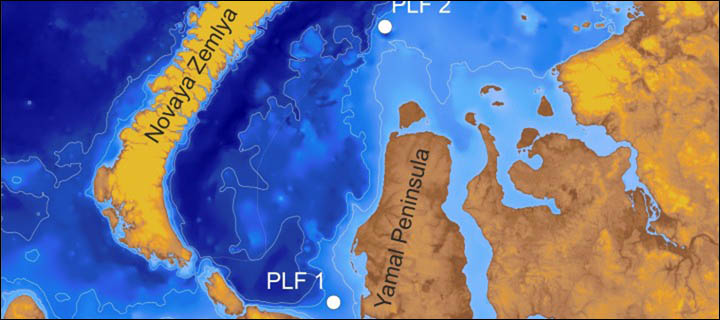
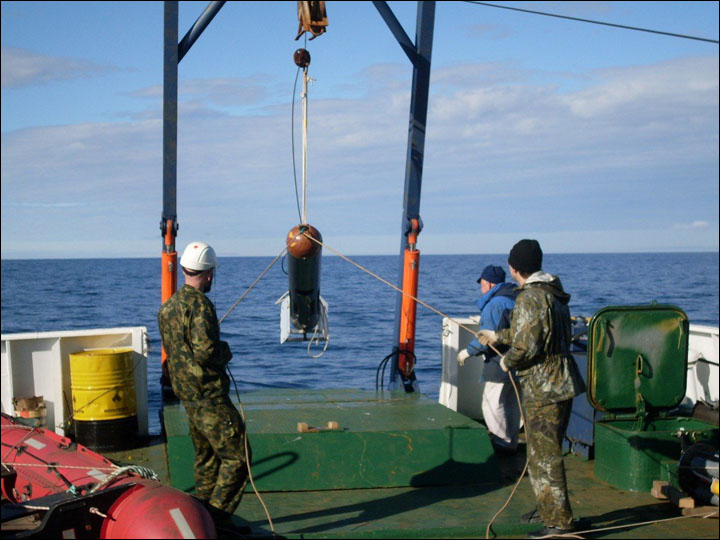
Two subsea pingos that were identified offshore (of) the very same area of the mysterious Yamal peninsula craters. Picture: Pavel Serov

From Siberian Times by Maja Sojtaric

Warning of methane blasts in Kara Sea adjacent to Yamal craters caused by gas eruptions associated with melting permafrost due to global warming.
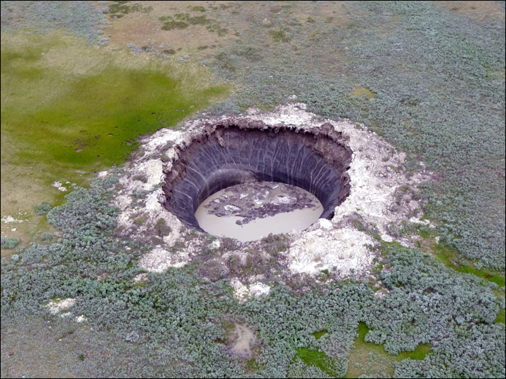
Huge attention has focused on the mysterious large holes that have suddenly appeared in the Siberian Arctic recently, and now there is evidence of a similar process underwater in southern areas of the Kara Sea.
Large mounds - described as pingos - have been identified on the seabed off the Yamal Peninsula, and their formation is seen as due to the thawing of subsea permafrost, causing a 'high accumulation' of methane gas.

 Kara Sea with the GeoGarage platform (NGA chart)

These mounds 'are leaking methane' and their 'blowout potential' poses a significant 'geohazard' to energy exploration in Arctic waters, according to new research by scientists at Centre for Arctic Gas Hydrate, Environment and Climate (CAGE) in Norway, supported by the Federal Subsoil Resources Management Agency of Russia.
For example, in a little-reported incident 20 years ago, during 'geotechnological drilling' by Russian vessel Bavenit in the Pechora Sea, a pingo gas deposit was opened, threatening the ship's safety with a sudden methane release, a process that has been claimed as the cause of the Bermuda Triangle in the Atlantic Ocean.

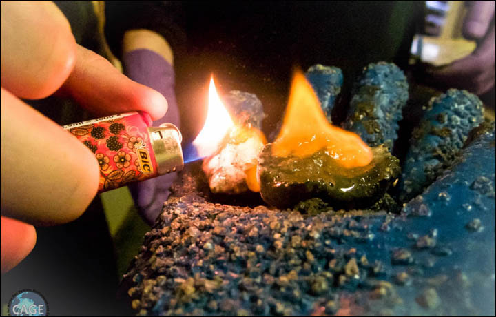
Gas hydrate is also known as the ice that burns. You can literally set it on fire.

Dr Pavel Serov, lead author of the research which is published in the Journal of Geophysical Research, said: 'Pingos are intensively discussed in the scientific community especially in the context of global climate warming scenarios.
 They may be the step before the methane blows out.'
The researchers focused on 'two subsea pingos that were identified offshore (of) the very same area of the mysterious Yamal peninsula craters', reported the CAGE website.

The Siberian Times has led the way in drawing attention to the land craters, publishing the views of scientists on their formation and spectacular pictures of the giant holes taken during expeditions to the new phenomena.
After initial doubts, scientists now believe the craters were formed by pingos erupting under pressure of methane gas released by thawing of permafrost caused by warming temperatures.

Now the Norwegian study 'shows how important methane accumulation is for the formation of subsea pingos'.
These structures are 'now found strewn on the ocean floor in the Arctic shallow seas', according to the research by CAGE, part of UiT The Arctic University of Norway.
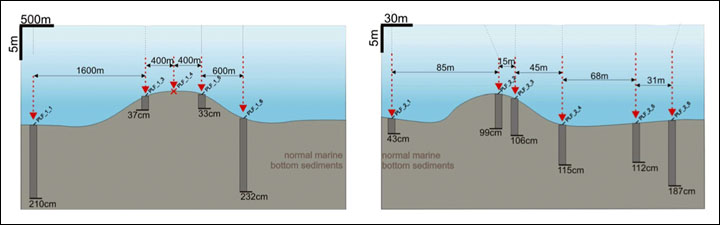
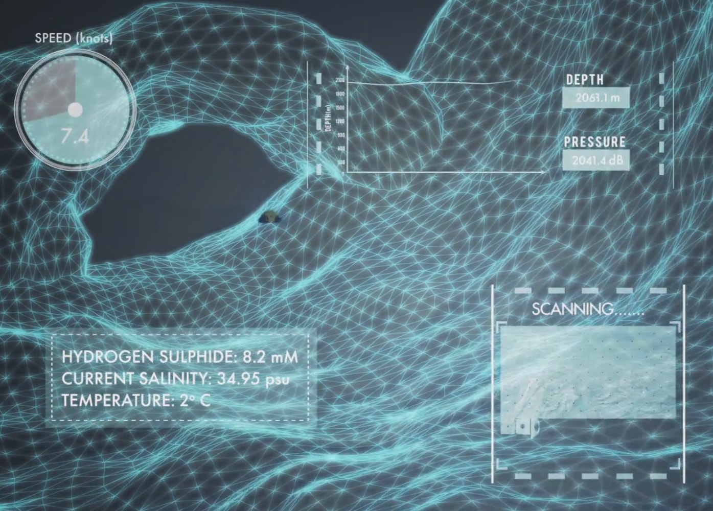
'The study area lies in the shallow South Kara Sea, at approximately 40-metre water depth.'

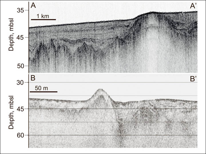
This is the view of the subsea pingo features as the scientists see them. Pictures: Pavel Serov

Initially it was thought the undersea pingos were 'relics of the Ice Age', but the groundbreaking new research indicates the reverse, indicated CAGE director Professor Jurgen Mienert, a co-author of the paper. 
'The CAGE study shows these newly discovered subsea pingos may be quite recent.'

Crucially, 'gas leakage from one of the ocean floor pingos offshore (of) Siberia shows a specific chemical signature that indicates modern generation of methane', state the researchers. 
'We suggest that the mound formed more recently, moving material physically upwards.' 
Likewise the processes leading to methane eruptions on the neighbouring peninsula are seen as very recent.  

The pingos in Kara Sea were revealed during the expeditions organized by VNII Okeangeologia in 2012 - 2013. Pictures: VNII Okeangeologia

'On land pingos are mainly formed when the water freezes into an ice core under soil, because of the chilling temperatures of permafrost,' states the website synopsis.
However, subsea pingos, may be formed because of the thawing of relict subsea permafrost and dissociation of methane rich gas hydrates.
Gas hydrates are ice-like solids composed of among other things methane and water.
They form and remain stable under a combination of low temperature and high pressure.

'In permafrost the temperatures are very low and gas hydrates are stable even under the low pressure, such as on shallow Arctic seas.
Thawing of permafrost leads to temperature increases, which in turn leads to melting of gas hydrates, therefore, releasing the formerly trapped gas.'

'The methane creates the necessary force that pushes the remaining frozen sediment layers upward, forming mounds,' said Dr Serov. Research indicates that 'subsea pingos can potentially blow out' without the 'massive attention' that has greeted the land pingo eruptions, which leave craters visible from space in their wake.
Yet in the Kara or other Arctic seas 'massive expulsions of methane' go into the ocean.
The researchers warned: 'For petroleum companies these areas may pose a geohazard. Drilling a hole into one of these subsea pingos, can be not only expensive but also catastrophic. During a geotechnical drilling in the close by Pechora Sea, an industry vessel unknowingly drilled a hole into one of these mounds. It triggered a massive release of gas that almost sunk the vessel.'

This is believed to refer to an incident in 1995 involving the Bavenit, west of Vaygach Island in the Pechora Sea. Dr Serov stated: 'We don't know if the methane expelled from the subsea pingos reaches the atmosphere. But it is crucial that we observe and understand these processes better, especially in shallow areas, where the distance between the ocean floor and the atmosphere is short.'

The Siberian Times in September carried a warning from Russian scientists of the threat on Yamal Peninsula - location of world's largest natural gas reserves - of methane explosions.
Scientists from Trofimuk Institute of Petroleum Geology and Geophysics said the process by which a series of craters formed was caused by  the melting of gas hydrates and the emission of methane.

 The Siberian Times has led the way in drawing attention to the land craters, publishing the views of scientists on their formation and spectacular pictures of the giant holes taken during expeditions to the new phenomena.
Scientists narrow down the cause and think it is related to warming.
Pictures: Vasily Bogoyavlensky, Vladimir Pushkarev

This accumulates in a pingo - a mound of earth-covered ice - which then erupts causing the formation of the holes.
One land pingo is believed to be poised to explode 'at any moment'.

It is now being constantly monitored by a Russian space satellite in an attempt to catch the moment when the eruption occurs.
Dr Igor Yeltsov, deputy director of the Trofimuk Institute, said of the newly-formed land craters: 'In the last decades, temperatures have climbed and caused the release of gas hydrates.
'This resembles a nuclear reaction. Last year I compared it with the Bermuda Triangle, because, according to our theory, the cause of this is a mass yield of methane. The volume of methane during transition from a solid to a gaseous state increases about 150 times.'

The largest Yamal hole 'is a unique object for science.
We did not have any chance to study such phenomenon before. 
The importance of the study increases if we take into account that six kilometres from the crater is a main gas pipeline, and 36 kilometres away is the Bovanenkovo gas deposit.'
Such eruptions 'can easily repeat', he warned.
'We need follow closely the processes with permafrost and gas hydrates on Yamal,' he said.
'We underestimate the danger that methane brings to us.'

Links :

Wednesday, December 16, 2015

Protection of our oceans must go hand-in-hand with the fight against climate change

The tiny Pacific island nation of Palau created one of the world’s largest marine sanctuaries,
saying it wanted to restore the ocean for future generations.
Photograph: Matt Rand/AFP/Getty Images 

From The Guardian by Tommy E Remengesau Jr

Island nations have been among the first to recognize that our ocean is in trouble.
Fish populations are diminishing, while sea levels are rising.
We are rapidly approaching a point of no return.
Now, our Pacific island nation, Palau, has enacted landmark legislation closing off 80% of its marine zone to create a vast ocean sanctuary.
By safeguarding an area larger than California (about 193,000 square miles), we’ve set aside more of our nation’s waters for full protection than any other country in the world.

 Palau with the GeoGarage platform (NGA chart)

For an island nation surrounded by waters still plentiful with fish, this may seem like a bold move. Yet the people of Palau overwhelmingly supported the creation of this ocean refuge.

Mindful of how other islands have suffered from the effects of overfishing, Palauans recognized that we needed to go big in order to protect our livelihoods.
We want to make sure our ocean, which is often in the path of poachers, remains full of fish to feed our families for generations to come.
Science shows that fully protected marine areas can help ameliorate the impacts of a changing climate.

 All around the world nature is threatened by the onslaught of mankind.
It is commendable that the state of Palau tries to stem the tide in its territory by far-reaching conservation measures.
Almost 60% of the marine environment is protected.
In 2009 Palau became the first shark sanctuary in the world and in 2012 Unesco added Palau's Rock Islands to the World Heritage List.

These marine reserves increase population sizes and reproduction rates of exploited species.
Fully protected areas have shown significantly more biomass than unprotected areas, a benefit that can spill over into other parts of the ocean.
By safeguarding areas from further degradation, marine reserves facilitate habitat recovery.
That’s why we are one of several island communities, working with The Pew Charitable Trusts’ Global Ocean Legacy campaign, that have acted this year to establish fully protected marine reserves.
In October, Chilean President Michelle Bachelet announced her commitment to work with the indigenous Rapa Nui community of Easter Island to create a marine park around the island, following a proposal by the islanders earlier this year to counteract the dramatic declines in their fish stocks.
In March, the UK government announced its intent to establish the world’s largest marine reserve around the Pitcairn Islands, following through on a plan submitted by the small island community that lives there.

 zoom on Palau

Together with other commitments – such as the September announcement by New Zealand’s prime minister John Key about his government’s intent to create a 239,000-square-mile sanctuary in the Kermadecs – this has been a historic year for the ocean.
In fact, 62% of the total ocean area pledged for high protections has been declared just since September of last year, when Barack Obama expanded the Pacific Remote Islands Marine National Monument originally established in 2009 by President George W Bush.
But there is still much more to be done.
Even with these large commitments, less than 2% of the ocean is highly protected – a far cry from the 30% that, according to marine scientists attending the 2014 World Parks Congress in Sydney, would need protection in order to have a meaningful impact on the health of the ocean.
We will not restore the health of our planet without repairing the well-being of the ocean.
Our climate is partly driven by our ocean, and marine reserves are one of many important tools that can be used to build the ocean’s resilience against the impacts of climate change.
“The past is responsible for today and today is responsible for what tomorrow will be,” my father told me after one particularly productive day fishing more than 40 years ago.
Full of a young boy’s pride over all the fish I’d caught, I eagerly awaited his praise.
Instead, he offered a reproach and an important life lesson: if we are not careful stewards of our ocean, there will be little of it left to depend on.

Links :

Tuesday, December 15, 2015

Canada CHS update in the GeoGarage platform

UK & misc. update in the GeoGarage platform

X Prize to map 4,000m-deep ocean floor with robots

The $7 Million Shell Ocean Discovery XPRIZE is a global, three-year competition challenging teams to advance breakthrough technologies for rapid, unmanned and high-resolution ocean exploration

From BBC by Jonathan Amos

There is a new X Prize to accelerate technologies to explore the ocean.
Shell is sponsoring the competition, which will challenge teams to map a 4km-deep, 500-sq-km area of sea floor using autonomous robots.
The award, which is valued at $7m (£4.6m), will have to be claimed before the end of 2018.
Previous ocean incentives put up by the X Prize organisation have helped develop oil clean-up solutions and sensors to monitor ocean acidification.
The new challenge was announced at the Fall Meeting of the American Geophysical Union (AGU) in San Francisco - the largest annual gathering of Earth scientists.
The motivation is the lack of high-resolution maps of the ocean bed. More than 90% of the sea floor has not been surveyed in detail.

X Prize technical director Dr Jyotika Virmani said much remained to be discovered about our planet.
"It was a Caribbean sponge that gave us AZT, the compound used in AIDS treatments. There are many more medical benefits just waiting to be discovered, but we have no idea because the oceans remain largely unexplored," she told BBC News.

 Besides mapping the sea floor, the organizers of the Ocean XPrize hope that the new technology it inspires could help researchers identify things such as sources of pollution and compounds that could be of medical benefit. (XPrize)

Although technologies already exist to survey the seabed at 4,000m down, the particular rules of the Shell Ocean Discovery competition will make even current experts in the field scratch their heads.
The entrants will have to deploy their solutions from land or from the air; they cannot use a ship or even be in the survey area at the time.
So, no cable can be used to remotely operate vehicles; they will need to be fully autonomous.

 "There's a Planet we've yet to understand. Ours."
Dr Jyotika Virmani: "Every time we go into the deep ocean we find something new"

There will be two rounds to the competition.
The first, to be held in 2017, will be undertaken at a shallower depth of 2,000m, and require teams to make a bathymetric map of at least 20% of a 500-sq-km zone of seabed in roughly 6-8 hours.
The top 10 teams will then go forward to the second round, which will be held at the full competition depth of 4,000m.
At least 50% of this area will have to be mapped in 12-15 hours.
A scanning resolution of 5m per pixel is demanded.
The teams will have to return high-resolution pictures from the deep as well, of a target specified by the organizers.
Control and communications in the dark at 4,000m will be tough enough, never mind the consideration of pressure, which will be about 40 megapascals - nearly 6,000 pounds per square inch.

 New XPrize encourages robotic ocean exploration :
1. make a bathymetric map
2. produce high-resolution images of a specific object
3. identify archeological, biological, or geological features

"Four thousand metres is certainly challenging and we're looking forward to seeing some very innovative technologies," said Dr Virmani.
X Prize CEO Dr Peter Diamandis added: "What we're going to see will be more autonomous; it's going to be smaller; it's going to be cheaper; it's probably going to be swarm in nature. This is what we're seeing because of the proliferation of cellphone technology. Robots are getting much more capable."
$1m of the $7m will be reserved for the team that can demonstrate new chemical and biological underwater sensors.
To win this, the group will need to "sniff" a target to its source in the survey zone.
That prize is sponsored by the US National Oceanic and Atmospheric Administration (Noaa).
"Right now we can bring seawater to a lab and detect what chemical and biological signatures are in there. We're looking to develop pioneering, breakthrough technology to do that in situ," Dr Virmani told BBC News.

 "A new era of ocean exploration" by Peter Diamandis (Boston Globe)

This is the third ocean-related X Prize.
The California-based organization plans two more under its Ocean Initiative, which is "designed to identify our oceans' grand challenges and what we can do to solve them".
The most famous X Prize saw a privately developed rocket pane fly into space.
Other competitions still in progress seek to put robots on the Moon and to develop Star-Trek-style "tricorders" to monitor people's vital signs.

Links :

Monday, December 14, 2015

Seabin Project : Cleaning our oceans one marina at a time

Seabin Project : Cleaning our oceans one marina at a time.

From SeabinProject

We have designed and made an automated rubbish bin that catches floating rubbish, oil, fuel and detergents.
It designed for floating docks in the water of marinas, private pontoons, inland waterways, residential lakes, harbours, water ways, ports and yacht clubs.
Can even be fitted to super yachts and motor yachts!
Right now we have a perfectly working prototype and we need the help of Indiegogo and supporters to set up a production of the Seabins to be built in the most sustainable and responsible way we can afford.

How can the Seabin help clean the worlds oceans starting with marinas?

We start close to the source of the problem in a controlled environment.
The marinas, ports and yacht clubs are the perfect place to start helping clean our oceans.
There are no huge open ocean swells or storms inside the marinas, its a relatively controlled environment.
The wind and currents are constantly moving the floating debris around in our oceans and in every port, marina or yacht club there is always some pollution heavy areas based on the predominant wind and current directions.
By working with these marinas , ports and yacht clubs we can locate the seabin in the perfect place and mother nature brings us the rubbish to catch it.
Sure we cant catch everything right now but its a really positive start.
It’s a big mission, but it can be done.
In fact, we’re doing it right now.

... and how does it work?

Seabin project | 24/7/365 Automated Marina Rubbish Bin Collector

The Seabin is situated at the waters surface and is plumbed into a shore based water pump on the dock.
The water gets sucked into the Seabin bringing all floating debris and floating liquids into the Seabin.
We catch all the floating debris inside the Seabin and the water then flows out through the bottom of the bin and up into the pump on the dock.
The water then flows through the pump where we have the option of installing an oil/water separator and clean water then flows back into the ocean.

 The shore based water pump plumbed into the Seabin

This process is constant, operating 24 hours a day, 7 days a week, 365 days a year.
Inside the Seabin we have a natural fiber “catch bag” which collects all the floating debris.
When this is full or near to full, the marina worker simply changes the catch bag with another one. The collected debris is then disposed of responsibly, the catch bag cleaned and now it is ready to swap again for the full one in the still operating Seabin.


We have designed the size of the Seabin and catch bag for safe working load for one person to safely change the catch bag.
If the Seabin is full it still works.
The flow of the water simply pulls all the surrounding floating debris against the Seabin and keeps it there.
The marina worker would simply scoop up the surrounding debris and then change the catch bag as normal.

What are the goals for the Seabin Project?
  • To help rid the oceans of plastics and pollution.
  • To have a Seabin production in place by mid to end of 2016 and start shipping.
  • To create Seabins from the most sustainable materials and processes available.
  • To have the lowest carbon footprint possible in the production of the Seabins by means of alternative materials and processes. Also by reducing shipping and having the Seabins manufactured in the countries of installation.
  • To create and support local economies with the production, maintenance and installation of the Seabins world wide.
  • To have future models of Seabins for specific locations.
  • To educate people and cultures about being more responsible with the use and disposal of plastics.
  • To setup educational programs for students in schools.
  • To convert our captured plastics into energy.
  • To reuse or recycle our Seabins for other uses and or applications.
  • To have pollution free oceans with no need for the Seabins.


Sunday, December 13, 2015

Drone seen by the sky : Le Bassin d'Arcachon


Aerial video of the Arcachon Bay (France) : Port de Meyran


La Pointe du Cap Ferret


Biganos


Andernos Les Bains


 L'île aux oiseaux

Links :