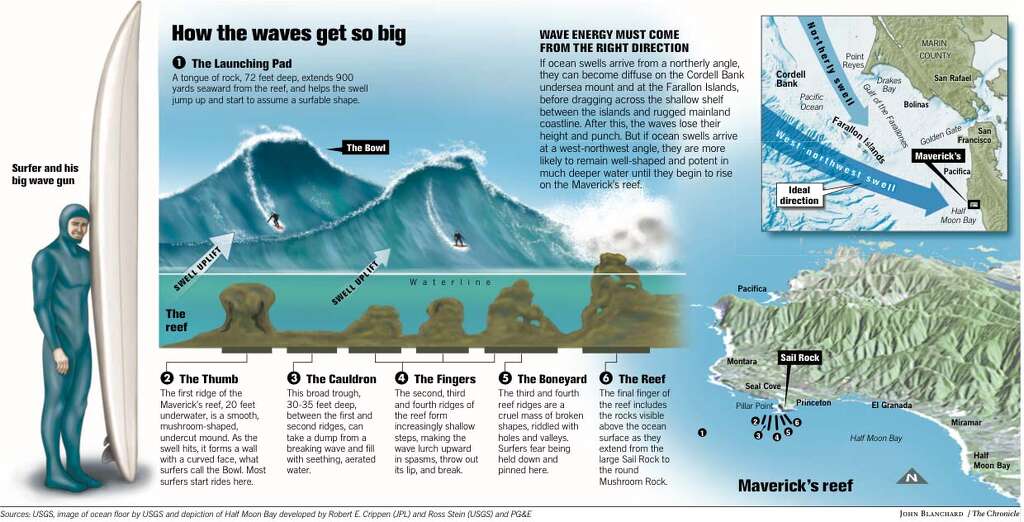
Just 20 minutes south of San Francisco, and 1/2 mile offshore from
Pillar Point Harbor, Maverick’s rises from the wintery horizon to form
perfect, massive waves that reach up to 60 feet.
...exploding with such
ferocity that it can be recorded on the Richter scale.
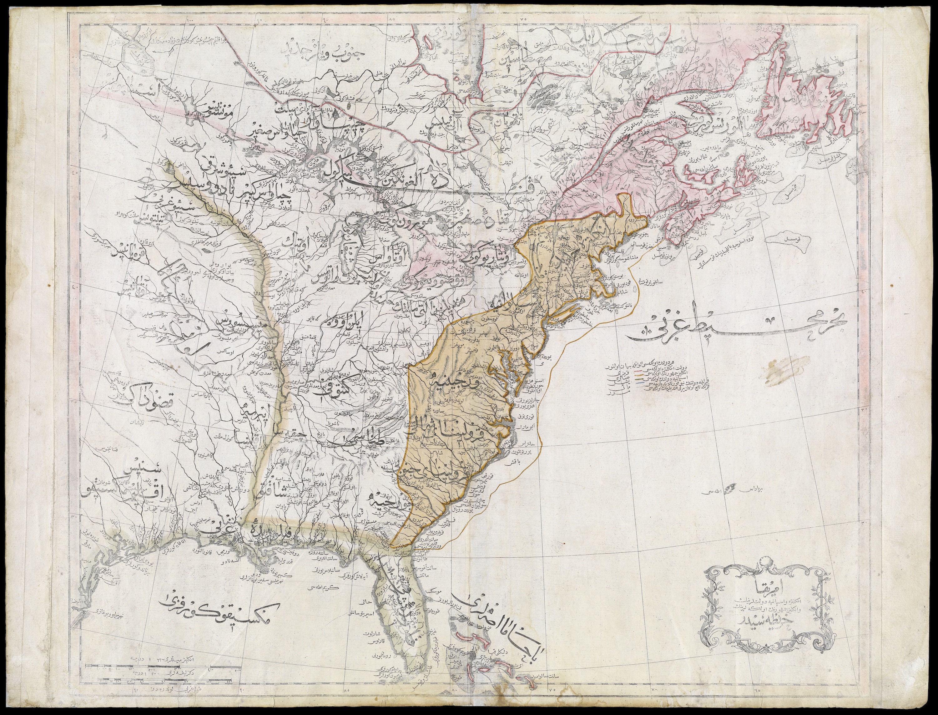
What did the United States look like to Ottoman observers in
1803?
In this map, the newly independent U.S. is labeled “The Country
of the English People” (“İngliz Cumhurunun Ülkesi”).
The Iroquois Confederacy shows up as well, labeled the “Government of the Six Indian Nations.” Other tribes shown on the map include the Algonquin, Chippewa, Western Sioux (Siyu-yu Garbî), Eastern Sioux (Siyu-yu Şarkî), Black Pawnees (Kara Panis), and White Pawnees (Ak Panis).
The Ottoman Empire, which at the time this map was drawn
included much of the Balkans and the Middle East, used a version of the
Turkish language written in a slightly modified Arabic script. Ottoman
script works particularly well on maps, because it allows cartographers
to label wide regions by elongating the lines connecting individual
letters.
This appears to be the first Ottoman map of the United
States, but Ottoman maps of North America have a much longer history.
The first were the 16th-century nautical charts of the famous Ottoman cartographer Piri Reis. Some of the last, drawn before the new Turkish Republic switched to Latin script in 1928, show air routes spanning the continental U.S.
American relations with the Ottoman Empire in the 19th century
were either commercial or missionary.
American missionaries to the
empire first tried to win Christian converts.
But after meeting with
little success, they turned to creating schools to spread the much more
popular American gospel of English fluency and engineering excellence.
At times, the mercantile and missionary impulses came into
conflict, such as when Greek Christians rebelled against the Ottoman
sultan.
Many Americans felt their government had a moral duty to stand
with co-religionists against a Muslim despot.
The U.S. government,
however, felt a more pressing duty to stand with its merchants and sea
captains, who’d been doing brisk business with the sultan.
Supposedly,
it was in recognition of U.S. support of the establishment that the
empire later sided with the Union during America’s own civil war.
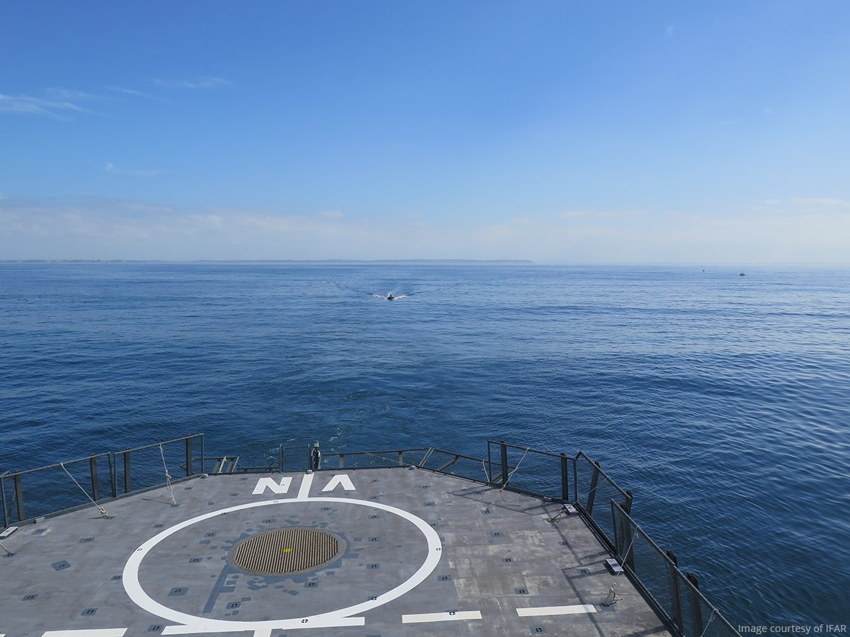
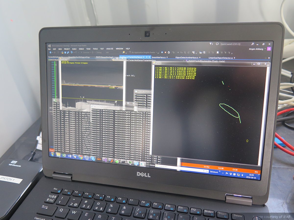
It looks like a standard radar screen, but the technology behind the red flashing dots that alert the crew of an ocean tanker to the presence of pirates is highly sophisticated.
Thermal cameras scan the seascape around a ship, while algorithms pick objects out on the horizon and determine whether they are fishing boats or pirate skiffs.
‘Pirates are desperate people,’ said Thomas Cane, a researcher with Britain’s maritime engineering consultancy BMT Group.
And asking sailors to fight back isn’t really fair.
‘They were not trained to be soldiers and fighting back would … put them at greater risk.’
Approximately 90 % of the world’s goods are carried by sea, as the most reliable and cost-effective way to move cargo around the globe.
But as with any thriving marketplace, the sea is a magnet for criminals who make millions of dollars for each ship they successfully hijack.
Somalia stands out in the recent history of piracy for a steep spike in incidents between 2009 and 2012 triggered by the political instability in the country.
The International Maritime Bureau reported that of the 53 ships hijacked worldwide in 2010, 49 were sailing off the country's coast.
In the face of a growing threat affecting not just East Africa but many of the main marine routes, from West Africa to Southeast Asia, the shipping industry started seeking ways to defend itself.
The countermeasures devised during the Somali piracy crisis were creative, ranging from water cannons to irritating, foul-smelling slime that would force the pirates to drop their weapons and jump into the water.
And when the use of armed guards turned counter piracy into a proper battlefield, the international community agreed that practical, ethical and legal questions needed addressing.
Thermal cameras sweep the horizon as pirate scanners trialled
Non-lethal
The EU-funded IPATCH project, coordinated by Cane, was launched with the aim of building a real-time monitoring system incorporating thermal surveillance cameras to estimate the likelihood of an imminent pirate attack.
It focuses on non-lethal measures and works by enhancing the radar already present on any standard ship.
Researchers piloted the new system in September last year, and are gearing up for a final demonstration on a commercial tanker in May.
Cameras around a ship can feed into a early detection system for pirates.
Image courtesy of BMT
The use of surveillance cameras is widely researched indoors and in urban environments, where everything is relatively stationary and the lighting conditions are favorable.
But at sea 'everything is moving around and a lot of the methods available don't perform well in a maritime environment,' Cane explained.
However, now that the technology has been adapted for the sea, 'the components can also serve a variety of other purposes, such as protecting oil rigs from attacks, or monitoring ports and harbours either for security or traffic management,' he said.
The IPATCH surveillance system uses 45 different parameters, including speed and size of the vessel on the horizon, what else is nearby, what time of the year it is and what the weather is like.
To turn the various parameters into scenarios and suggest what countermeasures to deploy in any particular case, the system taps into a database developed within IPATCH which collates and analyses all the piracy incidents that happened over the past five years.
The database is the result of a joint effort between the IPATCH team and another counter-piracy initiative supported by the EU, PROMERC.
PROMERC’s targeted impact is to reduce the vulnerability of EU merchant fleets and maritime supply lines to criminal abduction and extortion and thereby reduce risk to mariners, shipping, and the environment, while also reducing costs.
The project, which ended last year, had a similar objective – to collate information about how piracy works through the analysis of past incidents – but its focus was preventative.
But while IPATCH developed a system to reduce risk for ships already at sea, PROMERC devised a new way of helping shipping companies plan safer journeys.
‘We wanted to support maritime operators in their decision-making process, and help them assess the effectiveness of possible counter measures,’ says Professor Nikitas Nikitakos, at the University of the Aegean, in Greece, and a partner of the project.
Moon phase
First the team worked on route optimization, which is usually done ashore by the shipping company. The risk maps they produced offered a glimpse into the future perils of each journey.
By assessing factors such as moon phase, visibility, location and environmental conditions, an automated tool generated a recommended route which is as safe and as cost-effective as possible.
Anti-piracy system uses 45 different parameters, including thermal camera feeds and weather data
As in the case of the IPATCH real-time monitoring system, this voyage planner is underpinned by reliable data on how pirates operate.
The researchers created a dashboard that allows users to assess the effectiveness of any given counter-piracy measure through a series of filters and switches.
For example, a user may look for a defense measure that will work in broad daylight and can be installed before the start of the journey.
The system will work out which measures meet both the criteria and return a suggestion.
It also includes a system that allows a ship’s captain to choose the best non-lethal countermeasures to stop pirates getting aboard.
‘Piracy has negative ramifications in many different sectors,’ said Prof. Nikitakos.
‘It disrupts continuous shipping trade paths, it creates social problems when people are captured and ransoms have to be negotiated.’
Cyrus Mody, assistant director at the International Maritime Bureau, who was not involved in the project, agrees that better data and sophisticated technology are vital to plan and deploy the right assets, ensuring better value for money.
‘Piracy is a crime which is as fluid as the water on which it is committed,’ he said.
‘The criminals can easily move from one jurisdiction into another, while response agencies do not have this flexibility’, as organizations such as local law enforcement authorities need the proper permissions to enter the jurisdiction of another sovereign state.
Mody believes that ‘to facilitate a better response, information needs to be shared in a timely manner between the correct agencies,’ and having one point of access to the most updated knowledge on piracy incidents could be a game changer for marine security.
A group of geologists say they've enough evidence to confirm the existence of a new continent. Writing in the journal of the Geological Society of America, the group named the eighth continent "Zealandia."
Zealandia has been written off for decades “as
an amalgam of continental fragments and slivers” and ocean crust, but
now researchers say the land mass meets all the definitions of a
continent.
It's a vast, strange land; its canyons and mountain ranges almost entirely unexplored, its creatures like something out of myth.
Linz nautical maps overlayed on Google Maps imagery with the GeoGarage platform
From
what we know, it's beautiful — stretching more than a thousand miles
from Savage Seamount across Three Kings Ridge, past swamp forests and
volcanoes to the southern slopes.
Pigeons feed on cabbage trees in Zealandia, whales have beaks, and peanut worms crawl above light-less abysses.
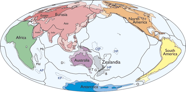
Simplified map of Earth’s tectonic plates and continents, including Zealandia.
Continental shelf areas shown in pale colors.
Large igneous province (LIP) submarine plateaus shown by blue dashed lines: AP—Agulhas Plateau; KP—Kerguelen Plateau; OJP—Ontong Java Plateau; MP—Manihiki Plateau; HP—Hikurangi Plateau.
Selected microcontinents and continental fragments shown by black dotted lines: Md—Madagascar; Mt—Mauritia; D—Gulden Draak; T—East Tasman; G—Gilbert; B—Bollons; O—South Orkney. Hammer equal area projection.
In
the last fraction of its long history, a relatively small band of
humans has settled Zealandia's greatest mountain peaks, which they call
the islands of New Zealand.
This place exists, though most of the 2 million square miles lie beneath the Pacific Ocean.
That shouldn't prejudice us against its significance, scientists argue in a paper that calls Zealandia “Earth's hidden continent.”
“The
large and the obvious in natural science can be overlooked,” the
researchers said in a newly published study in the Geological Society of
America's journal.
As measured by human landmarks, Zealandia
encompasses New Zealand and the island of New Caledonia about 1,500
miles to the north.
It stretches beyond both and is two-thirds the size of Australia.
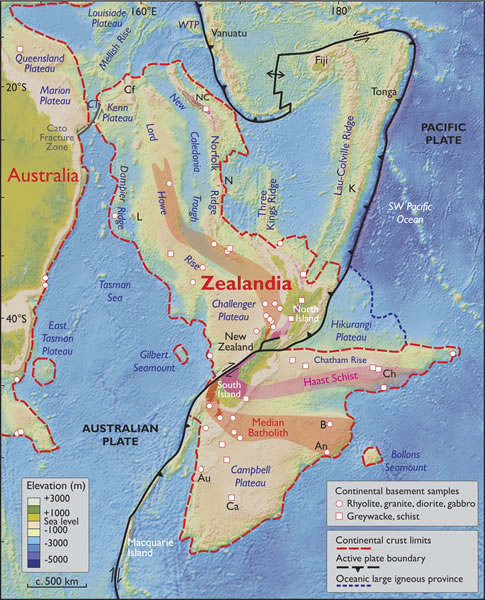
Spatial limits of Zealandia. Base map from Stagpoole (2002) based on data from Smith and Sandwell (1997).
Continental basement samples from Suggate et al. (1978), Beggs et al. (1990), Tulloch et al. (1991, 2009), Gamble et al. (1993), McDougall et al. (1994), and Mortimer et al. (1997, 1998, 2006, 2008a, 2008b, 2015).
It would have been immediately recognized as a continent, the
researchers argue, if Earth's peaks and valleys “had first been mapped
in the same way as those of Mars and Venus” — with no pesky water to
obscure the truth of rocks.
“If we could pull the plug on the
oceans it would be clear to everyone we have mountain chains and a big
high-standing continent above the ocean crust,” lead author Nick
Mortimer, a New Zealand government geologist, told Reuters.
Instead,
the researchers say, Zealandia has been written off for decades “as an
amalgam of continental fragments and slivers”: the wreckage of an
ancient supercontinent, Gondwana, which disintegrated when dinosaurs
walked the Earth.
We know Gondwana's orphaned survivors as Africa, South America, Australia and Antarctica.
Present day map of CRUST1.0 crustal thickness (Laske et al., 2013) showing the dispersed Gondwana continents of Australia, Zealandia, East and West Antarctica, and South America.
Note thin continental crust in vicinity of Mesozoic arc.
Thick coastlines in Antarctica are isostatically corrected ice-free coastlines (Jamieson et al., 2014).
Orthographic projection.
If Mortimer and his team have their way, Zealandia would be added to that list.
Zealandia as part of the former Gondwana supercontinent.
Upper panel shows Mesozoic orogen convergent margin that was active until ca. 105 Ma.
Lower panel shows pre-breakup intracontinental extension of Zealandia and West Antarctica from 105 to 85 Ma; seafloor spreading subsequently split Gondwana into its present-day constituent continents (Fig. 3).
Orthographic projections with East Antarctica fixed. From Mortimer and Campbell (2014).
Jut
like its former neighbors in Gondwana, the mass that became Zealandia
drifted off tens of millions of years ago, the teams says. It had the
misfortune of being stretched, thinned and 94 percent of it submerged —
so that when humans came along, they mistook it for the ocean crust.
“The
accuracy and precision of seafloor mapping have improved greatly over
the past decades,” the researchers say. They say Zealandia meets all the
definitions of a continent: a huge, coherent mass that sits above and
is distinct from the ocean crust.
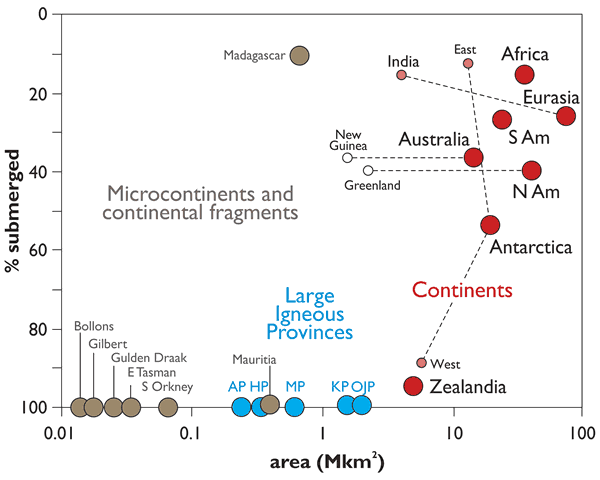
Areas and submergence of all of Earth’s geological continents (red symbols) along with microcontinents (brown symbols) and intraoceanic large igneous provinces (LIPs, blue symbols) shown in Figures 1 and 2.
Note x-axis is log scale.
Data mainly after Cogley (1984) except Zealandia data from Mortimer and Campbell (2014); microcontinents after Gaina et al. (2003) and Torsvik et al. (2013).
Emergent land area for Antarctica is the isostatically-corrected ice-free bedrock surface from Jamieson et al. (2014).
New Guinea and Greenland are arbitrarily given the same submergence value as their parent continents.
AP—Agulhas Plateau; KP—Kerguelen Plateau; OJP—Ontong Java Plateau; MP—Manihiki Plateau; HP—Hikurangi Plateau; N Am—North America; S Am—South America.
Zealandia has all the right rocks. It has “interconnected and throughgoing geological provinces,” the researchers say.
Calling it what it is, the scientists say, would mean “much more than just an extra name on a list.”
It
would help us understand the earth beneath our feet — and the parts of
it that are not — by exposing a continent unlike any other to
more research.
And yet, notes BBC News, “there is in fact no scientific body that formally recognises continents.”
That means Zealandia will become a continent only if members of its minority population — human beings — decide to call it one.
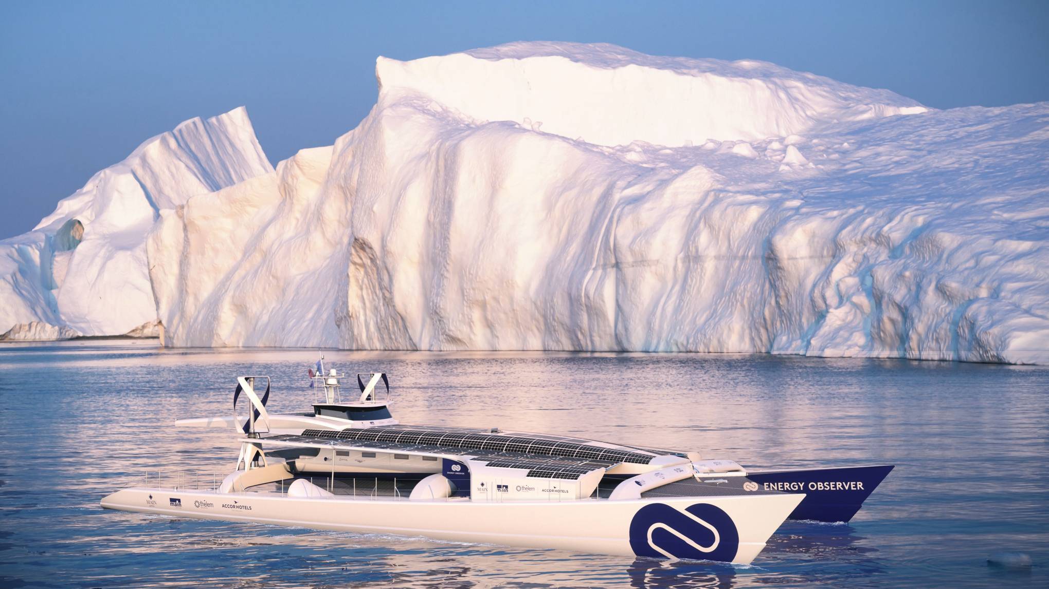
The Energy Observer is due to set sail in May, 2017 A 100-foot long catamaran that had a successful racing career before it was converted into a clean-energy vessel, Energy Observer is a $5.25 million ship will use solar, wind, and hydrogen energy to power its electric motors.
Remember Solar Impulse 2,
the solar-powered plane that circumnavigated the world in July 2016?
This could be the ocean-going equivalent. In a bid to prove the
effectiveness of hydrogen as a renewable fuel, Victorien Erussard and
Jérôme Delafosse will sail around the world in a boat powered by the gas
– made from the elements they encounter on the way.
The Energy Observer is a renovated racing catamaran from 1983 that had a long competitive history. In 1994, as ENZA New Zealand the boat won the Jules Verne Trophy for the fastest sail around the world.
“The problem is
that 95 per cent of the hydrogen that you use already is made out of
fossil energies,” says Delafosse.
“We will produce hydrogen onboard from
the ocean, we will clean and purify the water and then we will
electrolyse it and then compress it in tank storage.”
A publicity video for the project suggests that the ship will travel around France in 2017, and then move to the Mediterannian in 2018, and Northern Europe in 2019.
In 2020 it will attempt the trans-Atlantic and head to the Americas (focusing on North and Central).
In 2021, it will journey to the trans-Pacific and go on a tour of Asia and Oceania, visiting India, Africa, and the Middle East to end its trip in 2022.
The Energy Observer, which sets sail from Paris in May 2017, is an ex-racing
catamaran that can generate hydrogen from 130 square metres of solar
panels, two wind turbines, a traction kite and two reversible electric
motors.
Explorer Delafosse, 45, and Erussard, 37, an experienced
offshore racer, partnered with French research centre CEA-LITEN
to develop the technology.
“When we are over-producing energy, when we
have a lot of wind and sun, the idea was not to waste this energy and to
just keep it on board,” says Delafosse.
“Hydrogen is the best way to do
this because it's very light and the efficiency of hydrogen is three
times more than just fuel.”
Jérôme Delafosse and Victorien Erussard have developed the world's first boat to be powered solely by hydrogen generated by renewable energies. Energy is stored in lithium-ion batteries for short-term use, but the main source of energy is from the conversion of seawater into hydrogen fuel. Demonstrating the production and use of hydrogen as a clean energy is one of the main points of the Energy Observer's mission.
The Energy Observer has hydrogen tanks instead of a battery, so even though it weighs 30 tonnes, it is nearly three times lighter than MS Tûranor PlanetSolar, the last solar powered boat to circumnavigate the globe.
In theory it can also go three times faster – a potential top speed of 42 knots – although in practice Delafosse expects it to cruise at eight to 10 knots.
However, whereas the PlanetSolar went round the world in 18 months, the sponsor-funded Energy Observer team expects to take six years, at a cost of €4 million (£3.42 million) per year.
6 years, 50 countries and 101 stops around the world
Why so slow?
Because Energy Observer is set to make 101 stops, showcasing the potential of renewable energy at stop-offs around the world.
“We can use this technology in hotels, in houses, in cars… the idea is to be less dependent on the network,” Delafosse says.
“It shows how fast things can happen: as it did in London at the turn of the last century with [moving from] horses to cars, it will happen with renewable energy.”
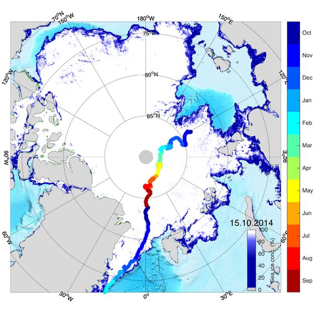
It is being billed as the biggest single Arctic research expedition ever planned.
Germany is going to sail its 120m-long research vessel, the Polarstern, into the sea-ice at the top of the world and just let it get stuck so it can drift across the north pole.
The 2,500km (1,550-mile) trip, to begin in 2019, is likely to take a year.
Researchers hope to gather valuable new insights on the region where Earth's climate is changing fastest.
Last
month the extent of Arctic sea-ice was the lowest ever recorded for a
January (during the satellite era), with temperatures several degrees
above the long-term average. Prof Markus Rex will lead the so-called MOSAiC project:
"The
decline of Arctic sea-ice is much faster than the climate models can
reproduce and we need better climate models to make better predictions
for the future.
"There is a potential that in a few decades the
Arctic will be ice free in summer. That would be a different world and
we need to know about that in advance; we need to know is that going to
happen or will that not happen?
Illustration of the MOSAiC polar expedition, before the ice completely freezes over trapping the research vessel RV Polarstern (Alfred Wegener Institute)
"Prof Rex outlined the plan for the Multidisciplinary drifting Observatory for the Study of Arctic Climate here at the annual meeting of the American Association for the Advancement of Science (AAAS).
The
German scientist, who is affiliated to the Alfred Wegener Institute in
Bremerhaven, said the €63m (£54m; $67m) expedition was very nearly all
funded, and would have key contributions from international partners.
A realtime 3D VR app for visualizing imagery from different camera systems deployed aboard the RV Polarstern.
Other European states, such as the UK, are involved - so too the Americans, the Russians and the Chinese.
The
mission has echoes of the Norwegian explorer Fridtjof Nansen's attempt
in the 1890s to be the first person to reach the North Pole by drifting
in a ship locked in ice.
A schooner called Tara also traversed the frozen ocean - from Siberian waters to the Fram Strait - in the same way a decade ago.
But
the RV Polarstern is an enormous science platform and its list of tasks
and goals dwarfs those of all previous efforts to work in the region.
"We’re
bringing a vessel full with equipment: many, many measurement
containers and remote sensing in-situ instruments," Prof Rex said.
"We'll
take water, ice and air samples. And we'll set up camps on the sea-ice
close to the Polarstern and others up to 20-30km away. And the whole
set-up will drift across the Arctic. That will give us a new and
absolutely fascinating insight into the climate system."
The
MOSAiC team even plans to make runways on the sea-ice so research planes
can take to the air in support of the RV Polarstern.
Possible route. The drift would start
in the East Siberian Sea. RV Polastern would be taken over the top of
the world and be released by the sea-ice in the Fram Strait between
Greenland and Svalbard
It will, however, be a difficult expedition for the scientists
involved, especially during the freezing midwinter period when the Sun
will not get above the horizon.
The researchers will also have to keep
their eyes peeled for predatory polar bears.
But Prof Rex said the
endeavour was vital to our understanding of this remote region and
stressed the relevance to the wider public who live far from the North
Pole.
"A warmer pole would affect weather patterns at mid-latitudes," he told BBC News.
"A
warming Arctic means that the temperature contrast between our
latitudes and the North Pole will be reduced in the future. This means
the flow of air, the wind, that blows around the Arctic will be less
zonal in the future climate, and it will allow for more excursions of
cold air from the Arctic to our latitudes, and more excursions of warm
air from lower latitudes to the North Pole. That certainly will have a
strong impact on our weather."
RV Polarstern is expected to take
up position ready to be captured in the sea-ice in the late summer or
autumn of 2019, with the intention of being released a year later.
 NOAA nautical chart with the GeoGarage platform
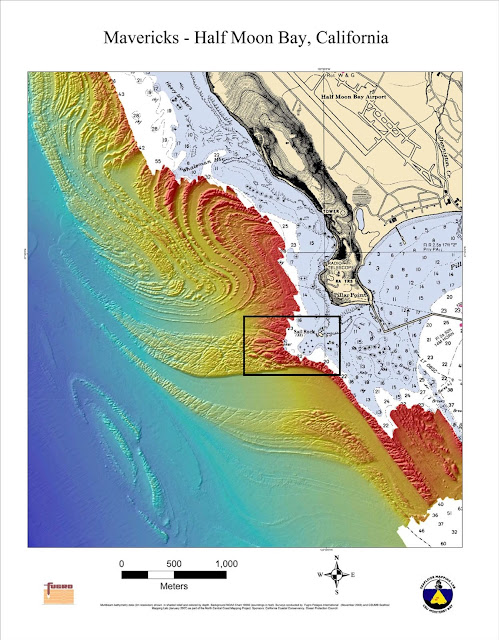 High resolution mapping of Mavericks
 Just 20 minutes south of San Francisco, and 1/2 mile offshore from
Pillar Point Harbor, Maverick’s rises from the wintery horizon to form
perfect, massive waves that reach up to 60 feet.
Just 20 minutes south of San Francisco, and 1/2 mile offshore from
Pillar Point Harbor, Maverick’s rises from the wintery horizon to form
perfect, massive waves that reach up to 60 feet.