New signal scheduled to become fully operational in 2024
On 24 January 2023, the European Union declared the Galileo High Accuracy Service (HAS) operational for testing, and it is scheduled to become fully operational in 2024. This free signal adds precise point positioning (PPP) options to capable receivers. HAS is being presented as an alternative to the current commercial offerings, so what can we expect from this new signal?
The EU regards HAS as an alternative to current GNSS augmentation services such as RTK and PPP from commercial providers. The Galileo HAS should aid various target markets and applications, including geomatics, aviation/drones and maritime, as well as autonomous driving and precision agriculture.
Following the UN/Austria Symposium 2023 on the theme of "Space for climate action: space applications and technologies for sustainability on Earth", UNOOSA is partnering with EUSPA to organize this webinar on the Galileo High Accuracy Service. This webinar covers the following topics:
- Galileo Services Portfolio: HAS among the Galileo services
- Galileo High Accuracy Service
- Why? - What is it?
- Service architecture
- Who are the HAS users? Key target markets and user segments
- How can they use HAS?
- What comes next: HAS service roadmap (planned evolutions)
Code phase and carrier phase differential GNSS augmentation
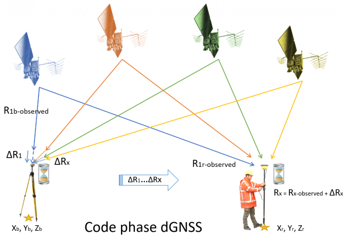
Code phase differential GNSS augmentation is a technique by which range corrections to the coded ranging signals are computed at base stations. The correction is the difference between the theoretical range between the station and a satellite, and the range as measured by the station. These corrections, which used to be mainly transmitted using terrestrial radio stations, are now usually transmitted to the user using satellites (SBAS). The system provides an absolute position with a service area of up to thousands of square kilometres. Accuracies depend on the service, but range from a few decimetres to a few metres horizontally. Vertical accuracy is generally poor and in the order of metres. Free SBAS using systems such as EGNOS and WAAS comes as standard in every modern receiver.
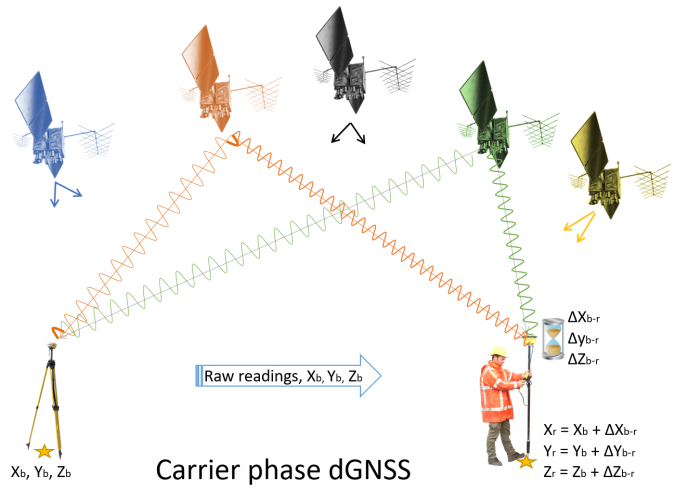
Carrier phase differential GNSS augmentation covers RTK and classic static GNSS methods. In this situation, a baseline difference is computed between a base and a rover. Rather than using the coded range signals, the final positions depend on the phase of the carrier wave from a satellite. Because carrier phase systems only compute a position difference between base and rover, they are relative systems. The final position is established by adding the base location to that difference. The system has a horizontal and vertical accuracy of a few centimetres, with a range of around 15–25 kilometres for most real-time applications.
Code phase differential GNSS augmentation.
PPP as an augmentation technique
The Galileo High Accuracy Service uses an augmentation technique called precise point positioning (PPP), which has been around for a few decades but has become an increasingly important technique over the past decade or so. In PPP, just as with other augmentation techniques such as code phase differential GNSS (e.g. SBAS) and carrier phase differential GNSS (e.g. RTK), a series of corrections from a base station is required. However, rather than provide or compute corrections to the ranges, PPP takes a different approach. In PPP, the base stations function as monitor stations, computing highly accurate ephemerides in near real time. It is these highly accurate ephemerides, rather than the predicted ephemerides as received from the satellites, that are then transmitted to and applied at the user’s receiver.
On top of the more accurate orbit and clock information, the technique uses accurate error models for determining the tropospheric variations. Finally, the algorithm uses both the ranging signals and the carrier phase observations to increase the accuracy of the position determination. With this information, the receiver computes not only the receiver coordinates but also the tropospheric delay and the phase ambiguities, similar to RTK. As a result, the overall horizontal and vertical position is accurate to within approximately a decimetre. Based on the author’s own recent evaluation of PPP signals, this technique is roughly two to three times less accurate than RTK under similar circumstances. The biggest disadvantage of PPP is the long computation times required to achieve the intended accuracy, with convergence times of up to half an hour depending on the situation.
Carrier phase differential GNSS augmentation.
Disadvantage of commercial PPP
The ephemerides required for PPP are either downloaded from a global network (usually with post-processing) or broadcast from communication satellites. When it comes to global real-time applications, only commercial signals have been available up to now (with the exception of the QZSS CLAS signal over Asia). Several servers provide free data, but this is used for post-processing or near-real-time applications. A big disadvantage of commercial PPP so far has been vendor lock-in, since each augmentation supplier uses its own correction format and receiver manufacturers generally only support one or sometimes two formats effectively.
How does the Galileo HAS differ from other PPP services?
The Galileo HAS works largely like any commercial PPP service, but with some major differences. The first is that the signal is available freely over the internet or directly through the Galileo E6-B signal. This means that if one or more Galileo satellites are in view and the user has a suitable receiver, the signals can be obtained without requiring a further (paid) licence or a special signal receiver. Because the corrections are transmitted from the Galileo satellite rather than from a geostationary communication satellite, it is much easier to receive the corrections in areas such as urban canyons. Unfortunately, it seems that only a limited number of receivers have implemented the Galileo HAS so far. Hopefully, this should improve now that the Galileo HAS is declared ready for testing, with a realistic view to full operational capability in the near future. The HAS employs an augmentation technique known as PPP, which has been in use for several decades but has gained significant importance in the last ten years.
Besides Galileo information, the Galileo HAS also transmits GPS information. Unfortunately, albeit unsurprisingly, Glonass and Beidou are not available, which reduces any multi-constellation receiver to a dual-constellation receiver. From a user perspective, this is a disadvantage, as especially Beidou satellites have a strong presence over Asia. The service is also not formally available over most of Asia and the Pacific (90°E-125°W from 60°S-60°N). Although not explicitly stated by the EU, the area without formal service (although corrections can still be received) coincides with the service area of QZSS, which operates its own, even more accurate, RTK/PPP service called the Centimeter Level Accuracy Service (CLAS).
Whereas many PPP solutions require at least 15 minutes for convergence, the Galileo HAS states a typical convergence time of less than 300 seconds for Service Level 1. At Service Level 2, this decreases to 100 seconds. Initial results show that the current convergence times to the ‘Service Level’ accuracies is indeed around 300 seconds for Galileo-only and combined Galileo/GPS solutions. In early tests for GPS-only solutions, the initialization time increased to around half an hour, with results worsening for moving GNSS receivers.
Architecture of the Galileo HAS system. (Image courtesy: EUSPA)
What about accuracy?
The accuracy for both service levels is stated as less than 20cm horizontally and less than 40cm vertically (95% confidence level). However, let us address the elephant in the Galileo HAS room: the stated accuracies are reasonable for horizontal accuracy, but not accurate enough vertically for most stated applications in the geospatial market. Moreover, these accuracies are not yet fully achieved. Early results using both GPS and Galileo constellations show an accuracy of less than 30cm horizontally and less than 40cm vertically (95% confidence level), with a current availability of over 90% (which should increase to 99% upon full operability).
Initial tests show that the Galileo HAS can achieve much better accuracies when taking into account a convergence time of around half an hour and using both GPS and Galileo corrections. In practice, this has achieved vertical accuracies of between 10 and 20cm (95% confidence). In comparison, Fugro Marinestar G2+, a commercial PPP solution using GPS and Glonass corrections, achieved vertical accuracies of between 3cm and 10cm (95% confidence), with an annual global average of around 6cm.
Galileo HAS performance (adapted from: Naciri, N., Yi, D., Bisnath, S. et al. Assessment of Galileo High Accuracy Service (HAS) test signals and preliminary positioning performance. GPS Solut. 27, 73 (2023). https://doi.org/10.1007/s10291-023-01410-y)
Assuming that, from a commercial-political perspective, the EU intends to stay relatively close to the stated accuracies rather than the achievable accuracies, the Galileo HAS is unlikely to be used much for the intended applications of coastal and inland hydrographic surveys and (vertical) drone positioning. For hydrographic and drone surveys, the proposed service levels are not nearly good enough and RTK or commercial PPP solutions will continue to be used. In construction and precision agriculture, the accuracy is only good enough for certain applications, and RTK will probably continue to be used for machine control for quite some time.
With a horizontal accuracy that is much more in line with achievable PPP accuracies, the Galileo HAS does have a future in some GIS/mapping applications as a replacement for SBAS, giving higher accuracy and a better signal in otherwise ‘denied’ areas such as urban canyons. Moreover, the system may be useful in developing nations in cadastral surveys and to improve horizontal navigation of drones. Additionally, it could be useful in offshore construction and dynamic positioning applications, provided that operators are willing to take the risk of a ‘free’ signal without further assurances. However, the major application of the Galileo HAS is probably in autonomous driving, where it will provide a much more accurate position and – even more importantly – more stable correction signal. This will aid in the more accurate navigation of autonomous vehicles at a global level.
When Russia invaded Ukraine last year, the Black Sea seemed unlikely to become much of a battleground. The Ukrainian navy, after all, had only one warship, which it was forced to scuttle as Russian troops advanced on the shipyard where it was being repaired, in the city of Mykolaiv. Snake Island, a maritime outpost guarding the western approaches of Odessa, Ukraine’s biggest port, fell to Russian attackers on the first day of the war. Odessa itself braced for an amphibious assault that would have cut Ukraine off from the sea altogether.
The fact the landings never came was the first sign that Russia’s dominion over the sea was not as absolute as it seemed. A more ringing indication of that came in April of last year, when Ukraine managed to sink the flagship of Russia’s Black Sea fleet, the Moskva, using a newly developed anti-ship missile. Two months later intense Ukrainian bombardment drove the occupiers from Snake island. But it is only much more recently that Ukraine has begun to demonstrate a capacity to strike targets across the Black Sea.
In early August a Ukrainian naval drone—another new weapon—damaged a Russian landing-ship just off Novorossiysk, a big Russian port far to the east of the war zone. The following day another drone damaged a Russian oil tanker off Crimea, the peninsula that dominates the Black Sea, which Russia seized from Ukraine in 2014. On October 1st aerial drones struck a helicopter base in Sochi, some 600km away from the closest Ukrainian-held territory. Most dramatically of all, over the past month, Ukrainian missiles and drones have repeatedly hit targets across Crimea, culminating in the destruction of the headquarters of Russia’s Black Sea fleet in Sevastopol on September 22nd.
Russia also seems to be intensifying the war at sea. In July it withdrew from a pact overseen by the un whereby it allowed Ukrainian grain exports to pass safely across the sea. It has threatened to sink any cargo ships calling at Ukrainian ports and has repeatedly bombed Ukrainian docks and grain silos in an effort to throttle Ukraine’s maritime trade. Since Russia and Ukraine both have the capacity to strike at shipping and since, as a diplomat puts it, the Black Sea is to grain what the Persian Gulf is to oil, an escalation in naval warfare could have a harrowing impact on global food markets. In fact, the Black Sea is also a big conduit for oil, and is central to the economies not only of Russia and Ukraine, but also Turkey and other littoral states. If it truly becomes a war zone, the world will feel the repercussions.
For the most part, the war in Ukraine has been dominated by infantry, tanks and artillery, as well as long-range drones and missiles. But even though the six amphibious assault ships that Russia deployed to the Black Sea just before the outbreak of hostilities have not been used, the threat to Ukraine’s southern shores has in some ways shaped the conflict. For one thing, the possibility of a coastal landing meant that Russia could menace Ukraine from three directions, and obliged Ukraine to spread its forces thinly in response.
Much the same logic has applied to the war in the skies. Excluding Iranian-made drones, around a fifth of all Russian missile strikes on Ukraine between January and March of this year originated at sea. Attacking from the sea, as well as from land and air, has allowed Russia to place a greater stress on Ukraine’s air defences, which have to watch for attacks from every direction bar the west.
Ukraine’s response has in some ways been a triumph. The sinking of the Moskvahas obliged Russia to keep its ships away from the shore. And the steady bombardment of Sevastopol has turned a huge naval base into something of a liability. Several ships previously berthed there have been pulled back to Novorossiysk. “They are like mice running away,” scoffs a Ukrainian naval officer. Ukraine has achieved “the functional defeat of the Russian Black Sea Fleet”, crowed James Heappey, Britain’s junior defence minister, this week.
image: the economist
But for all its successes, Ukraine’s main goal, to ensure that cargo ships can come and go safely from Odessa and its other ports, remains elusive. After Russia withdrew from the un’s grain initiative, Ukraine set up a new shipping route that hugs its coastline until the Romanian border to the west of Snake Island (see map). The intention is to keep civilian vessels as far from Russian guns as possible, and to get them as quickly as possible into the territorial waters of Romania, a member of nato, where Russia would presumably hesitate to launch attacks. So far ten ships have come to Odessa this way, loaded grain and set sail again, without incident, despite Russia’s threats.
A senior Ukrainian official tells The Economist that intelligence indicates Russia is planning an attack on civilian shipping, in an attempt to disrupt the new export route. Russian warships can fire missiles with a range of 2,500km, which would allow them to strike cargo vessels from a safe distance. By the same token, Russia can use submarines to lay mines even if its surface ships are forced to stay away, suggests Sidharth Kaushal of the Royal United Services Institute (rusi), a think-tank in London (although Ukrainians argue that the shallow waters along the new export route would make that difficult). Even if Ukraine were somehow to sink the entire Russian fleet, missiles fired from Crimea could easily destroy a lumbering cargo ship off Odessa.
Another Ukrainian official notes that Russian strikes on Ukrainian ports are already raising insurance premiums across the Black Sea: “Insurers see where things are headed. They are not daft.” But, adds the first, “Two can play at this game.” Ukraine has warned that, if Russia attacks civilian vessels, it will retaliate in kind. It has been demonstrating its capacity to hit distant naval targets not to escalate the war in the Black Sea, he says, but to deter Russia from doing so.
image: the economist
The stakes for both countries are high. Before the war, roughly 60% of Ukraine’s exports passed through its ports on the Black Sea. The volume of trade has since contracted dramatically, both because of the Russian blockade and because of the broader disruptions caused by the war to farms, factories and infrastructure. Even when the grain initiative was operating, Ukraine’s exports were a fraction of what they once were (see chart).
Some of the missing volumes have been diverted to barges on the Danube river. Ukrainian officials say they are managing to export over 3m tonnes of grain a month in that way at the moment. Another 1m tonnes is being exported by train and a smaller amount by lorry. But these alternatives are all much slower and more expensive than piling giant freighters with cargo. The cost of exporting a tonne of grain by river barge, for example, is roughly $120, versus $30-40 for exports by sea. Russia is bombing the new routes as well. What is more, Ukraine simply does not have adequate road, rail and barge capacity to substitute for deep-sea ports. The result is a further blow to an economy already gutted by the war, and further loss of tax revenue and foreign exchange for a government that is borrowing unsustainably.
But Russia has a lot to lose as well. More than 80% of its grain exports and about 30% of its oil exports pass through ports on the Black Sea. These shipments have barely been affected by the war so far. Russia’s military force in Syria is also dependent on fuel and supplies shipped via the Black Sea. This “Syrian express” probably ranks high on Ukraine’s list of potential targets should the war at sea expand in scope.
Crimea and punishment
To inflict serious injury on the Russian economy, Ukraine does not need to sink all Russia-bound ships, but simply to damage enough of them that insurance premiums shoot up and Russian ports become commercially unattractive. “We don’t have the drones to stop all Russian trade. But if you are asking if we can dramatically increase the financial stakes? Sure, no problem,” says a Ukrainian official.
That would be bad not only for Russia, but also for global food markets. In the early stages of the war, they were gripped by panic. After all, when fighting broke out, Russia and Ukraine together accounted for an eighth of the calories traded worldwide. In 2021 they were the world’s first and fifth biggest exporters of wheat, shipping 39m tonnes and 17m tonnes respectively—28% of the world’s traded supply. Both also grow a lot of grain used to feed animals, such as maize and barley, and are the top two producers of sunflower seeds, giving them an 11.5% share of the vegetable-oil market.
Within days, the invasion sent wheat prices to more than $12 a bushel, up from $7 two months before; the cost of maize shot to its highest in a decade. This was largely because of the Russian blockade of Ukraine’s ports on the Black Sea. Traders also feared that the war and Western sanctions might impede Russian exports. Many, including The Economist, warned that global food shortages were looming.
Agricultural markets are much calmer now, despite the growing risk of escalation in the Black Sea. Wheat currently costs little more than $5 a bushel, less than it did before the war began. In fact, prices fell back to pre-war levels during the summer of 2022 and have stayed there since.
That was less because of the un’s deal to revive Ukraine’s grain exports than because of bumper crops elsewhere. Russia, whose farming industry is exempt from Western sanctions, harvested an unprecedented 100m tonnes of wheat in 2022. Other countries, from Brazil to India, also enjoyed bumper crops.
This year looks much the same. Ukraine is growing less wheat than before the war and its exports are down sharply because of the scrapping of the grain deal. But Russia has again produced a bountiful harvest, as have many other exporters. Whereas last year crops were threatened by La Niña, a climatic phenomenon that often saps yields in big cereal-growing regions in the northern hemisphere, this year, notes Carlos Mera of Rabobank, a Dutch lender, the reverse pattern, El Niño, promises more benign conditions.
Attacks on commercial shipping in the Black Sea would doubtless send prices leaping again. Insurers would raise their rates or refuse to underwrite cargoes at all. Grain would not be the only casualty: some 2m barrels of oil and a further 1m barrels of refined petroleum products are exported through the Black Sea every day.
But the effects might again be short-lived. The Russian government is already insuring lots of the oil tankers that visit its ports, to help shipping firms evade Western sanctions. It could do the same for other exports as well. Despite rising tensions and Western pressure, lots of shipping firms are willing to transport Russian goods, says Matthew Wright of Kpler, a ship-tracking firm. What is more, Russia has a very dense network of oil pipelines. It could probably divert a good part of the oil that is normally shipped across the Black Sea to terminals in the Baltic. (The refined products would be harder to move around in this way.)
War and peas
Transporting grain by road from Russia’s farming heartlands in the west to distant terminals in St Petersburg, the Baltics or the Pacific would be slow and prohibitively expensive. (Ukraine already struggles to truck much smaller volumes over shorter distances.) But Russia has several grain terminals on the Black Sea and the adjoining Sea of Azov, so it could use an ever-shifting assortment of ports and shipping routes to keep cargoes out of harm’s way. Given that Russia has struggled to choke off Ukraine’s grain exports despite its vastly superior navy and air force, it is hard to imagine Ukraine snuffing out Russian trade.
For all these reasons, Viktor Kurilov of Rystad Energy, a consultancy, reckons attacks on commercial shipping might cause crude-oil prices to rise by only $5-7 a barrel before settling $1-2 above where they would otherwise have been. Wheat markets might be jolted more severely, at least for a time. That would not be painless: the brief spikes in food prices last year, the un calculates, helped lift the number of people around the world facing severe hunger by 65m. But a lasting cataclysm is unlikely.
Not so Bosporous any moreimage: reuters
A critical variable in all this is the stance of Turkey, in effect the gatekeeper to the Black Sea. Under a treaty called the Montreux Convention, Turkey is obliged to let commercial shipping pass unhindered through the Bosporus and Dardanelles, the narrow straits connecting the Black Sea to the Mediterranean. But the treaty places restrictions on the number and size of transiting warships. When war breaks out on the Black Sea, it gives Turkey the power to prevent belligerents from sending in reinforcements and to close the straits entirely to warships from non-littoral countries. So when Russia invaded Ukraine it barred Russia from reinforcing its Black Sea fleet, but also stopped nato countries from sending in ships, despite being a member of the alliance itself.
With the collapse of the grain deal, Turkey is under pressure to help prevent Russia from strangling Ukrainian trade. Bulgaria and Romania, two natomembers with coastline on the Black Sea but relatively weak navies, would welcome a show of force from the alliance. Some Ukrainians are calling for Western naval convoys to protect commercial shipping.
But Turkey is loth to allow anything that increases the risk of a broader conflagration and that antagonises Russia. By sitting on the fence, Turkey’s president, Recep Tayyip Erdogan, has won valuable concessions from his Russian counterpart, Vladimir Putin. Russia let Turkey delay some payments for Russian gas, worth perhaps billions of dollars, a sop that helped Mr Erdogan conceal the scale of his economic mismanagement before elections earlier this year. Turkey’s refusal to join other nato members in imposing harsh sanctions on Russia has also been lucrative: trade between the two countries nearly doubled last year, to $62bn.
Some analysts suspect that Mr Putin also promised Mr Erdogan that Russian troops sent to enforce a ceasefire would instead stand aside as Azerbaijan, Turkey’s main regional ally, seized control of a disputed province from ethnic-Armenian rebels in late September. “Turkey is using Russian weakness to extract concessions,” says Yoruk Isik, who runs Bosphorus Observer, a consultancy. “As long as it continues to get them and as long as trade with Russia continues,” he adds, “Turkey will do its best not to confront Russia.”
Russia is equally reluctant to rock the boat, as it were. If Russia were to attack commercial shipping, the pressure on Mr Erdogan to allow nato ships into the Black Sea would increase dramatically. One thought holding Mr Putin back may be the risk of pushing Mr Erdogan into a less accommodating position.
It is just another way in which neither side is likely to prevail completely in the war at sea. Ukrainian drones will continue to embarrass Russia, but the Russian navy will remain a menace to Ukrainian cities and shipping. Russia can probably push insurance rates sky-high, reckons Mr Kaushal of rusi, “irrespective of how uncomfortable the Ukrainians can make Sevastopol”. And although naval battles will never be the main focus of the fighting, fears of an alarming flare-up will always linger.
The country is expanding its aquaculture in deeper waters as a more sustainable solution, but the environmental impacts are concerning scientists
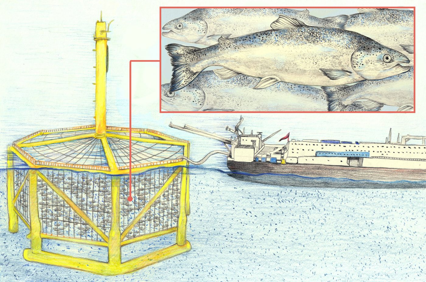
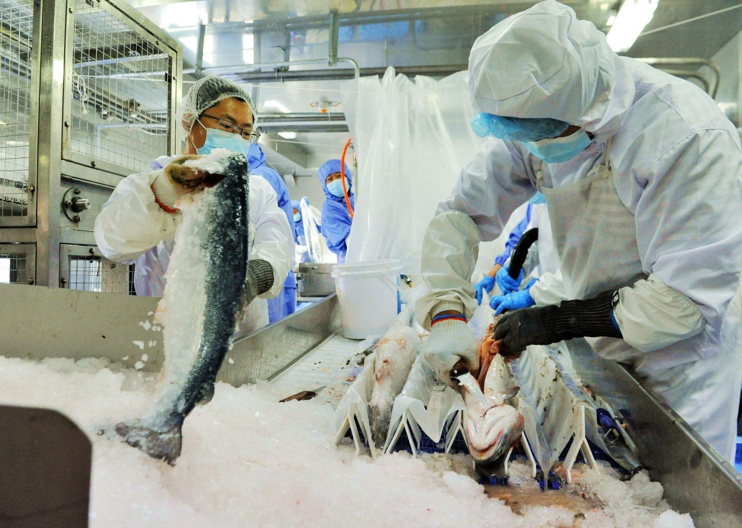
Over 100 nautical miles off the coast of China in the Yellow Sea, a huge octagonal structure rests in the water. This is no new-look oil rig. It’s Deep Blue 1, China’s first offshore aquaculture base for farming salmon.
At its corners, the yellow octagon has steel columns extending 30 metres into the water. Enclosed by black mesh, they form a cage with a volume of 50,000 cubic metres, and room for 300,000 salmon. The yield is nearly 1,500 tonnes of fish per year.
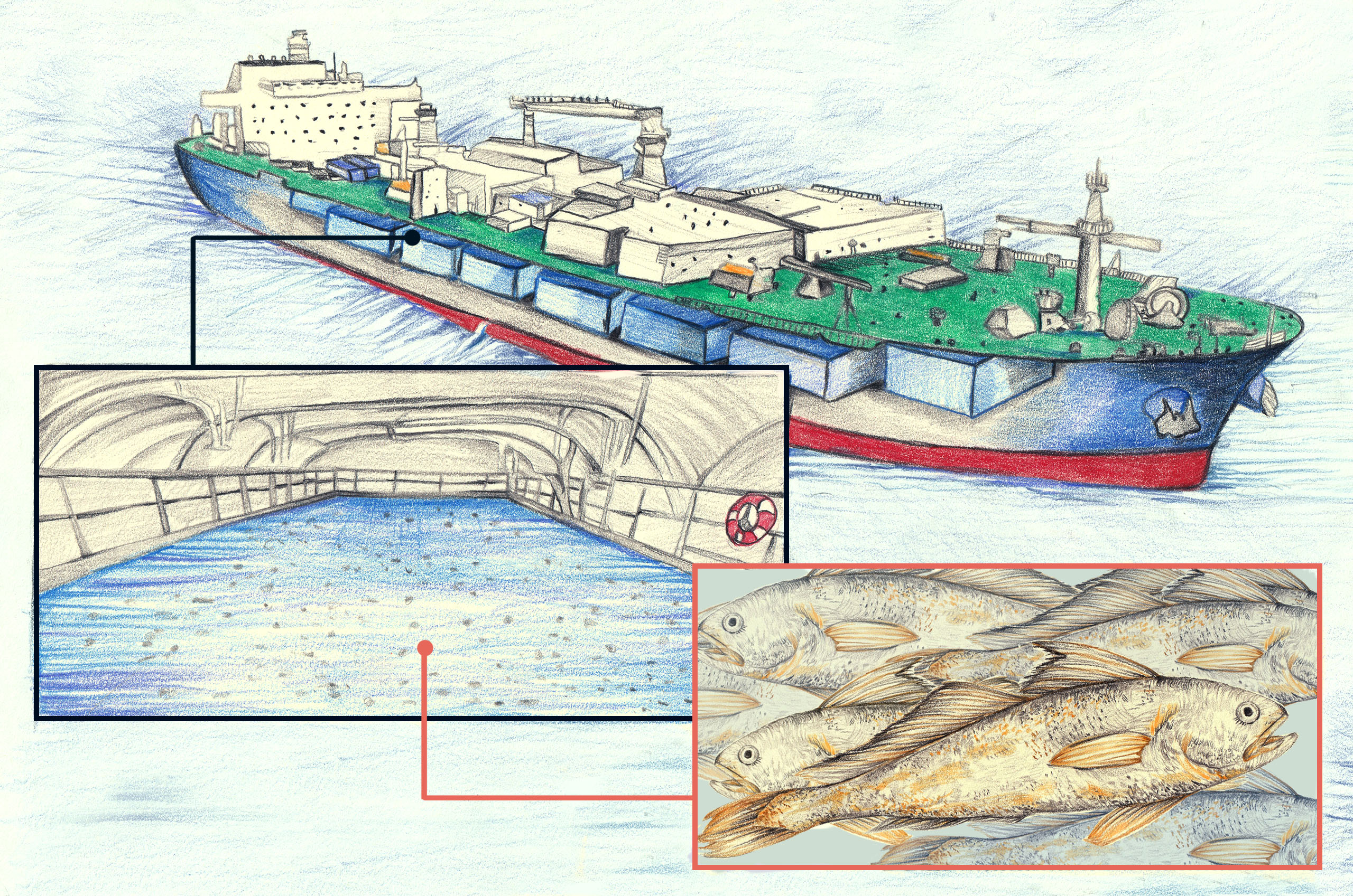
Deep Blue 1 is merely a taster for future developments in Chinese offshore aquaculture. The Guoxin 1 aquaculture vessel is designed to produce 3,700 tonnes of fish annually. The ship cruises between the Yellow and South China seas, avoiding typhoons and “red tide” algal blooms, and keeping to waters in the 22C to 26C range suitable for the fish. This factory-type aquaculture vessel contains 15 tanks with a total volume of nearly 90,000 cubic metres. Stock density is four to six times that of traditional net pens.
The Guoxin 1 is a floating fish farm the size of an aircraft carrier. It has 15 fish tanks in its hold and aims to produce 3,700 tonnes of fish annually. In its first trial phase, the vessel produced more than 1,200 tonnes of large yellow croaker.
Following successful trials of the initial project, upgraded versions of the vessel, in the form of Guoxin 2 and Guoxin 3 are due for delivery in March 2024.
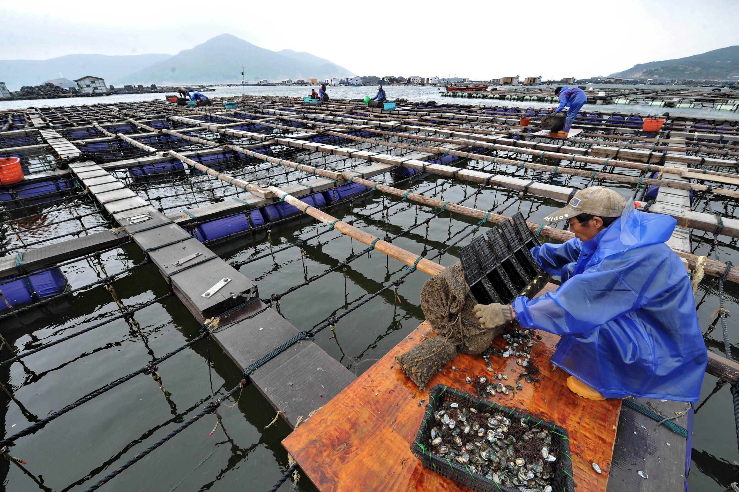
China is developing various forms of offshore aquaculture. According to data released in June by the Ministry of Agriculture and Rural Affairs, coastal provinces have already brought into use more than 20,000 “gravity cages” – each formed of a net and a floating collar – 40 steel-framed sea cages, like Deep Blue 1, and four aquaculture vessels. China’s offshore aquaculture currently spans nearly 44 million cubic metres of water, yielding almost 400,000 tonnes of seafood – more than 20% of national mariculture, or marine farming, output.
The ministry says: “With another five years, we aim to increase the scale of offshore aquaculture nationally by 16 million cubic metres, to more than 60 million cubic metres, and achieve annual offshore aquaculture output of more than 600,000 tonnes – more than 25% of sea-farmed fish products.”
China's deep-sea smart aquaculture vessel upgrades fisheries industry
Offshore aquaculture: known for its large scale
In the policy paper “The opinions on accelerating the development of offshore aquaculture”, jointly released in June by the Ministry of Agriculture and Rural Affairs and eight other Chinese government departments, offshore aquaculture is defined in a way that stresses the use of large-scale installations such as gravity cages, steel-framed cages, aquaculture platforms and aquaculture vessels, supported with mechanisation, automation and smart technology. They should all enable aquaculture to be undertaken at scale and efficiently in deep offshore waters, the paper states.
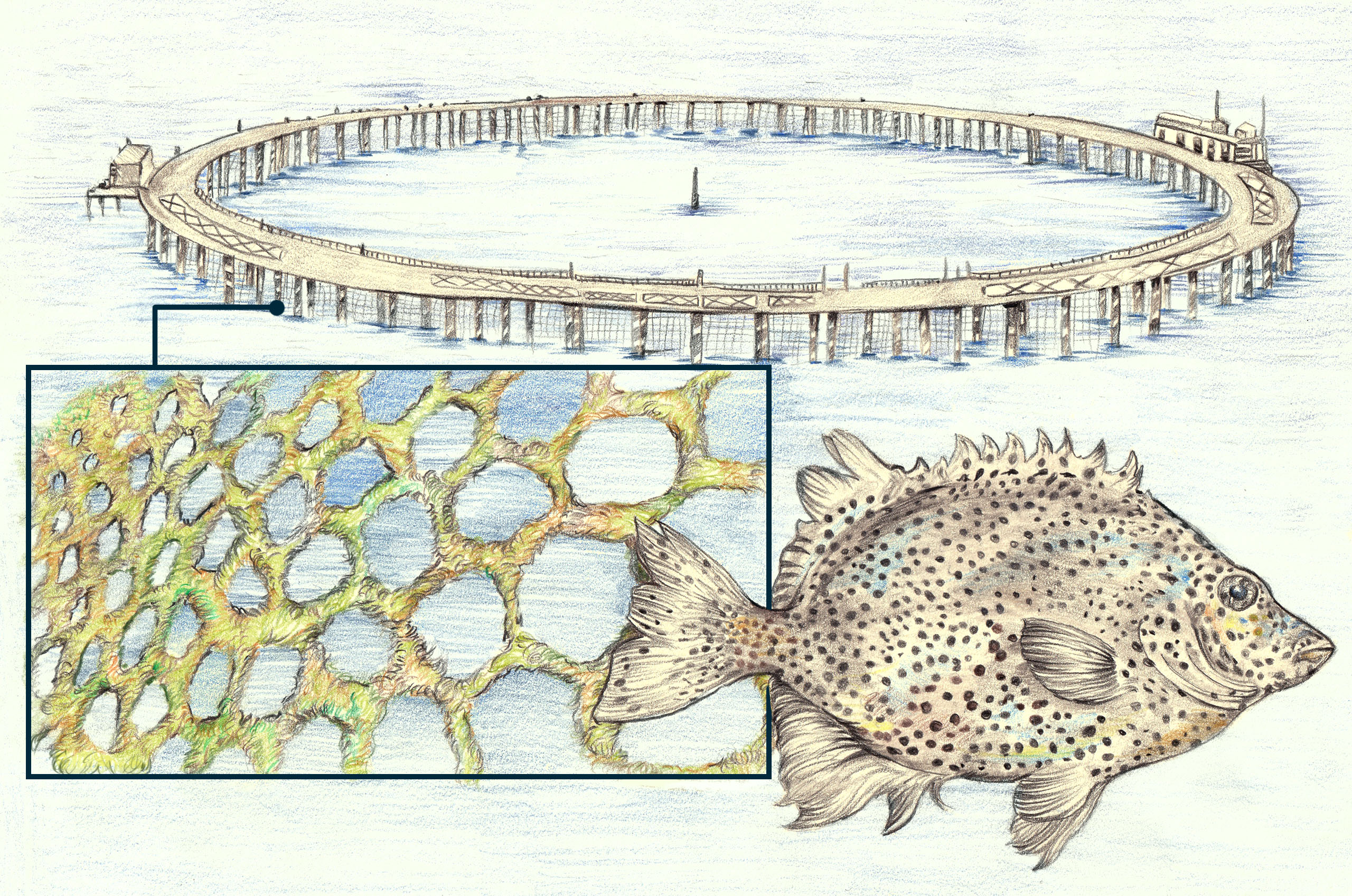
Another of China’s large-scale offshore fish farms is the Blue Diamond 1. Positioned 10km off the coast of Shandong province’s Laizhou Bay, this fenced sea-cage boasts a volume of 160,000 cubic metres, and is currently farming spotted knifejaw (Oplegnathus punctatus), a high-value sushi-grade species. The facility was built to withstand typhoon-strength winds and nine-metre waves. (Illustration: Ricardo Macía Lalinde / China Dialogue Ocean)
Offshore aquaculture operations are often large-scale in order to achieve cost reductions. This is necessary because they are situated far from land supplies, meaning it costs a lot to deliver feed, supply energy and transport catches. Increases in production capacity and centralising of operations are also needed to reduce costs.
Lin Ming, of the Chinese Academy of Engineering (CAE), explains in a paper that the greater the volume of a sea cage, the lower its per-unit operating costs and the higher its cost-effectiveness. Larger volumes of water also create conditions more like those in which wild fish grow, and generate a higher-quality yield. Cui Mingchao, an associate researcher at China’s Fishery Machinery and Instrument Research Institute (FMIRI), sums up the thinking behind the Guoxin 1 design as “big in capacity, with costs spread out”.
Similarly, experts advise selecting large fish species for farming. Guan Changtao points out that the scale of offshore aquaculture farms means they have high per-cage yields, with centralised harvesting and delivery to market. So, it is necessary to ensure that there is a market for the fully grown fish. Guan wants the industry to reach a consensus on jointly developing a setup based around five staple species: large yellow croaker, golden pompano, grouper, sea bass and flounder, along with fish such as cobia, brown croaker, seabream, and amberjack.
Staff aboard the support ship monitor Deep Blue 1’s salmon via a video feed. Many offshore fish farms have underwater cameras like this inside their pens, part of the “smart technology” needed to manage such large and hard-to-access facilities. (Image: Amadeja Plankl / Alamy)
Workers process Deep Blue 1’s salmon on site. These fish meet EU standards, but are destined for the Chinese domestic market, where they can be competitively priced compared to imported salmon. Given the current high cost of offshore fish farming, operators are opting for large, high-value species. (Image: Alamy)
It is difficult to gauge market response as offshore fish farming is still being trialled. To date, only limited quantities of fish have been harvested and brought into the distribution chain. A senior figure in the fisheries media, who wishes to remain anonymous, tells China Dialogue that compared to catches of wild fish, yields from offshore aquaculture are currently more stable, and the model is more sustainable. Moreover, the quality of fish farmed far offshore is better than that of fish from near-shore operations, due to an obvious difference in water quality.
Offshore aquaculture products largely sit in the upper-middle price range. In the case of salmon, for example, the domestically produced offshore aquaculture product beats imports in terms of price and freshness.
Zhao Xiaoxia, deputy chief engineer of Guoxin 1, said in an interview that the vessel’s large yellow croaker currently sell for around twice the price of fish farmed inshore. Being quasi-wild is a distinct quality advantage, too, given that a wild individual could easily be sold for more than 1,000 yuan. As the industry develops and upgrades, it can be expected that there will more affordable, good-quality fish on the market, he added.
An urgent need for sustainable blue transformation
Rich in micronutrients and high-quality protein, aquatic products are becoming increasingly popular as a sustainable and healthy dietary choice. A report by the UN Food and Agriculture Organization (FAO) on the state of world fisheries indicates that global seafood consumption is now more than five times what it was 60 years ago, and as world population and income rise, the consumption of seafood will continue to grow.
Overfishing has long been a source of concern, so the spread of sustainable fisheries in recent years is a positive development. However, the FAO report states that the proportion of fish stocks at biologically sustainable levels decreased from 90% in 1974 to 64.6% in 2019, meaning that overfishing persists. Aside from the impact on biodiversity and ecosystems, this threatens fishery yields.
Overreliance on near-shore aquaculture is also problematic. China is the world’s largestproducer and processor of aquatic products, with fish farms dotted all along its coastline. Previously dominant and cruder forms of fish farming have left a legacy of environmental pollution and ecological problems in the country’s near-shore waters. Direct discharge of fish farm effluents, accumulations of faecal matter and the uncontrolled use of fishery drugs – in particular, antibiotics – have all contributed to the degradation of coastal mangroves and the increasing occurrence of red tides. Research has shown that the increase in red tides correlates with the increase in shrimp farming.
Abalone farmers in south-east China’s Fujian province clean out their cages after a red tide killed all of their stock in 2012. Increasing outbreaks of such toxic algal blooms have been linked to waste from aquaculture. (Image: Amadeja Plankl / Alamy)
Fortunately, conditions have eased for the near-shore ecology thanks to the pace of green development in recent years. In 2016, the Ministry of Agriculture and Rural Affairs required local authorities to delineate areas where aquaculture was prohibited, restricted or permitted by law, bringing structure to aquaculture distribution. The media reported that China removed 300,000 near-shore net pens and 2.4 million mu (160,000 hectares) of fish farms in 2018 alone. Guangdong, China’s leading fisheries province, has also demonstrated its commitment to curtailing near-shore aquaculture and shifting towards more environmentally friendly development further offshore, by mandating an “orderly withdrawal” of fish farming from waters shallower than 10 metres.
Another concern is the impact of climate change. The FAO report found that freshwater aquaculture was becoming more vulnerable in China due to the changing climate. It also noted that the country’s near-shore aquaculture operations are now being impacted by typhoon-related weather every two or three years, and that typhoons are becoming more frequent.
The UN group on nutrition states that moderate consumption of seafood does not necessarily increase the negative environmental impacts of production activities if their recommended supply and consumption protocols are followed. Organisations such as the FAO, The Nature Conservancy and WWF are unanimous in encouraging responsible marine aquaculture, which they regard as a solution to food problems and a way of developing a sustainable blue economy.
A diamond-shaped pen used to farm highfin amberjack (Seriola rivoliana) in Hawaiian waters. A similar pen off the coast of Panama, which raises cobia, represents one of the largest offshore fish farms in the world. (Image: David Fleetham / Alamy)
Findings from academia have also boosted confidence in marine aquaculture. A 2019 studyanalysing water samples collected near net pens off the coast of Panama found that coastal fish farms can have a relatively small pollution footprint if properly located. Research has also found that the feed-conversion ratio and carbon emissions for salmon farming are much lower than those for several other protein products such as pork and beef. Another study shows that a wide variety of fauna can often be found in or around mariculture farms, which may benefit localised ecological restoration.
It is against this backdrop that China has set its sights on the ocean expanses, where the water is cleaner, and begun exploring offshore aquaculture. As technology matures and is increasingly applied, offshore aquaculture can be expected to simulate wild environments and produce “blue” food – caught and cultivated in freshwater and marine environments – and to do so with precision and efficiency.
According to the FAO fisheries report, China’s total mariculture yield now far exceeds its catch from ocean fisheries. The “Opinions”, released in June this year by the nine government departments, are being viewed in the industry as a policy foundation that will last for years to come. There has been speculation in the industry that this may prompt a new wave of aquaculture in China headed by high-tech farms.
Offshore aquaculture’s marine ecology controversy
While some experts in the sector applaud the environmental positives associated with the development of offshore aquaculture, there has also been scepticism about the mariculture approach. Doubters say aquaculture systems of this kind simply shift the negative impacts out of sight while exacerbating them, as exemplified by the bigger carbon footprint that results from running facilities far offshore.
Hu Zhenyu, director of the Centre for Sustainable Development and Marine Economy, expressed this and other concerns in an article about the high carbon production, energy consumption and expense of aquaculture vessels. Guoxin 1, for example, extracts water from dozens of metres deep, around the clock, to ensure the water in its tanks is replaced 16 times a day. This relies on traditional diesel power, requiring fuel that is costly and difficult to resupply, while also generating exhaust gas, effluents, noise and other pollution.
As we shall see, Deep Blue 1 is even more controversial in terms of its ecological impact.
Sea temperatures in the middle of the Yellow Sea are lower than in surrounding areas. This particularly suits the valuable coldwater fish of the salmonid family being raised in Deep Blue 1. The low-temperature zone, which at 130,000 sq km is equivalent in size to Shandong province, is called the “Yellow Sea cold water mass”.
Deep Blue 1 (visible in the background) sits in a part of the Yellow Sea where the water remains cold all year round, which suits the salmon. There are now plans to position a cluster of these farms in the same location, creating the equivalent of an industrial park on the ocean. (Image: Alamy)
Since 2014, a team led by Professor Dong Shuanglin at Ocean University of China (OUC) has been working with the Shandong-based fisheries firm Wanzefeng Group to trial localised farming of Atlantic salmon in the area of the cold water mass. Having successfully regularised fish harvesting by Deep Blue 1, Wanzefeng Group are reported to be proposing an ambitious plan, called “12+1”. This entails developing an offshore aquaculture park, consisting of 12 upgraded Deep Blue 1 farms and a central integrated management platform, in the cold water mass zone.
China Dialogue spoke to a concerned marine ecologist who prefers to remain anonymous. They explained that the Yellow Sea cold water mass is sharply stratified by temperature, due to stable currents in the sea basin. These keep temperatures at the bottom low all year round, harbouring many cold-water species. The idea of using the cold water mass for aquaculture before establishing a marine protected area policy there, is inherently problematic, the ecologist continued.
Furthermore, the operation and development of projects such as Deep Blue 1 are constrained by ecological conditions in that area of the sea, said the ecologist. Deep Blue 1 is currently farming Atlantic salmon of Norwegian origin – a cold-water species suited to growing 13–15C waters. The ecologist points out that, firstly, the movement of throngs of fish inside sea cages churns water from the upper and lower layers, raising the temperature beyond what is suited to Atlantic salmon. And secondly, the area’s stable currents are not helpful for dispersing fishery pollutants.
The window of time suitable for fish farming in the area is also rather limited, according to the ecologist. In the winter, when temperatures in the cold water mass are lower, the farmed fish become lethargic and grow more slowly. Higher temperatures in summer, on the other hand, are not ideal for growth, and submersing the cage further into the low-temperature layer would risk wiping out the stock due to limited amounts of dissolved oxygen at the bottom. Deep Blue 1’s actual aquaculture production cycle is therefore relatively constrained. As publicly reported, the facility’s previous two harvests were carried out before summer, and the farmed fish had a growing period of only about six months in the cage.
The technology for operating Deep Blue 1 in cold water mass waters is not yet mature. It requires high levels of investment, due to the cost of the operations, and its long-term ecological impact needs to be further evaluated, says the ecologist.
In Deep Blue 1’s early days, it was struck by sharks which wrecked the cage, resulting in a number of fish breaking free
Regarding developing and exploiting the resources of the Yellow Sea cold water mass area, the ecologist suggested that the special habitat should be managed through the establishment of marine protected areas (MPAs) and no-trawl zones. Then the unique biodiversity and the high value fishery resources would be supported. Only at this point, could offshore farming models that are ecologically friendly and have high socio-economic benefits, be carried out in the area to secure blue food supply, the ecologist concluded.
Subsequent risks that cannot be ignored
The problem of fish escaping from deep-sea fish farms has long been a matter of concern, in China and elsewhere. When farmed fish enter the wild, they disrupt local food chains. They tend to grow fast but are ill-adapted to the natural environment. And by interbreeding, they alter the genetic makeup of wild populations, reducing survival rates for the young and affecting genetic diversity. Moreover, they are more likely to carry diseases, and can spread contagion to other communities of fish.
A study of Norwegian fish farms found that 92% of escapes involved marine fish farms. In Deep Blue 1’s early days, it was struck by sharks which wrecked the cage, resulting in a number of fish breaking free. Chile, which is number two in the world for salmon farming, is also a major source of fugitive salmonids, on account of storms, other extreme weather events, and sabotage by competitors. For this reason, it introduced new regulations earlier this year imposing fines for unrecovered catches of escaped fish, and operational bans of between one and four years. Aquaculture operators are also required to fund two years of marine monitoring to determine the derivative effects of any escapes.
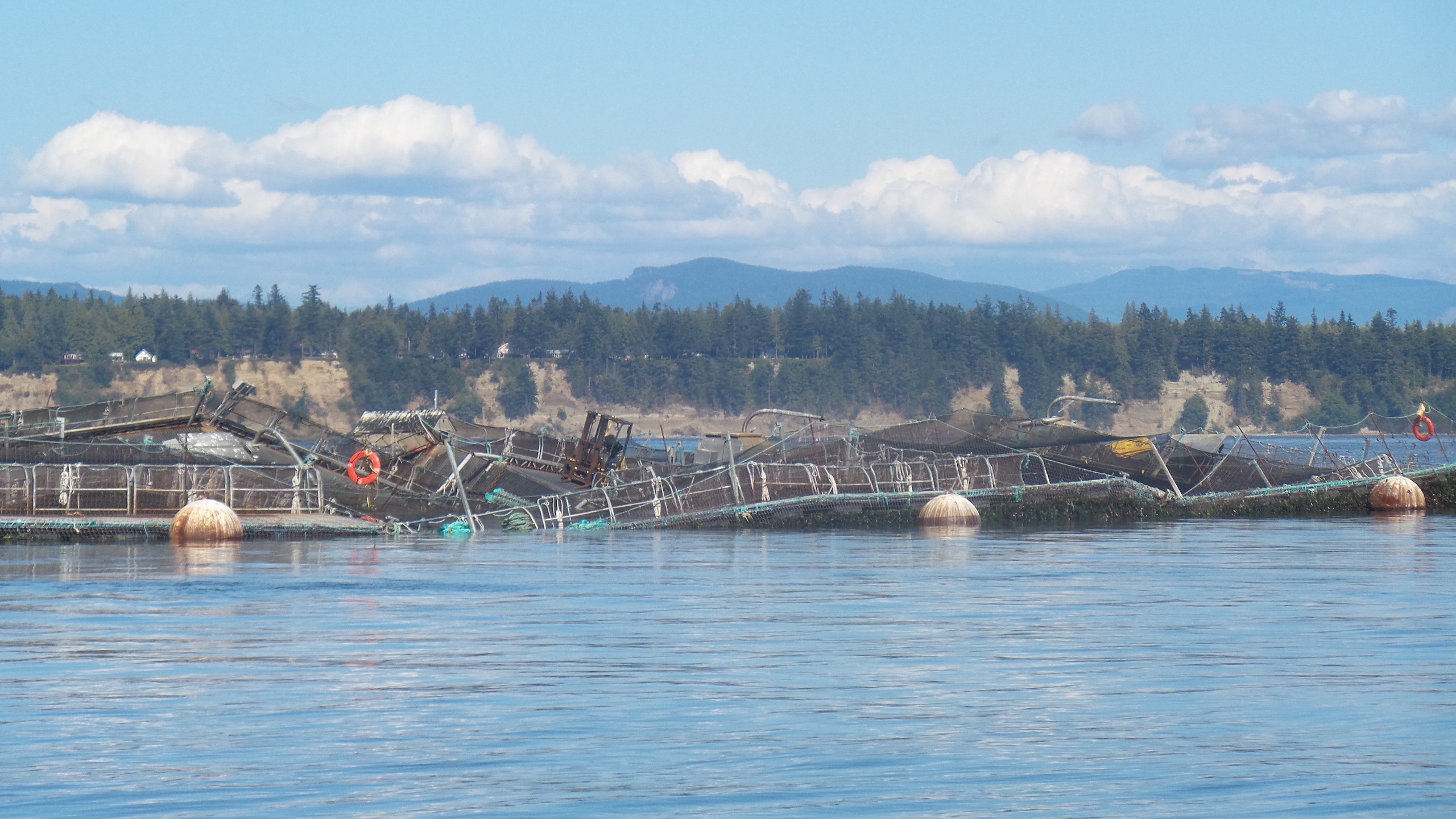
The collapsed pens of an open-water farm rearing non-native Atlantic salmon off Cypress Island in the US state of Washington. When the pens collapsed in August 2017, over 200,000 fish escaped, prompting fears that struggling native Pacific species of salmon would be impacted. In response, the state banned Atlantic salmon farming, and last year awarded the Lummi tribe US$595,000 in damages. (Image: Washington State Department of Natural Resources / Flickr, CC BY-NC-ND)
Unlike in Norway and Chile, where there are fjords free of waves, China’s offshore aquaculture environment is heavily subject to oceanic wind and waves. In fact, the excessive safety risks associated with offshore aquaculture are a significant deterrent for aquaculture firms. In 2014, the fisheries sector in Hainan province suffered more than 2.7 billion yuan in direct losses as a result of super typhoon Rammasun. Extreme weather occurrences will become increasingly difficult to manage under climate change.
Records show that extreme waves along the coast of the South China Sea can be as high as 16 metres and exert 50,000 tonnes of force per 100 metres of wave front. The destructive power of the sea under such conditions is far worse than can be imagined. Take the example of HDPE (high-density polyethylene) deep-water sea cages, which are common in China’s offshore aquaculture industry. Analysis by Lin Ming of the Chinese Academy of Engineering indicates that cages of this kind would deform under catastrophic sea conditions, rendering their structure and anchoring system unsafe, and very likely resulting in the death or escape of farmed fish.
As a solution, Lin Ming’s team has proposed the construction of wave-dissipation installations close to aquaculture areas, cutting them off from the roughest of sea conditions behind gigantic “walls”. Earlier studies indicate that such installations can reduce a 16-metre wave to about 2 metres. Constructing offshore defences of this kind may in future mitigate the risks to offshore aquaculture posed by climate change and its impacts.
An innovative new mapping project aims to present a more expansive view of permafrost, not simply depicting the physical geography but also showing how changes in permafrost affect human communities in the Arctic.
The maps are being produced as part of the Nunataryuk project, an EU-funded initiative that brings social scientists and natural scientists together to study the implications of permafrost thaw in the Arctic – a critical indicator of climate change.
The maps will be published in the forthcoming Arctic Permafrost Atlas, a 100-page coffee table–style book to be released in 2023 in both print and digital formats.
The atlas, a key output of Nunataryuk, will showcase the latest research, data, and knowledge about permafrost from researchers within and beyond the project. As an interdisciplinary publication, it will also focus on the people whose lives revolve around permafrost and explore strategies they can use to adapt to permafrost thaw.
The atlas is intended to be a beautiful book that will draw in a general audience as well as researchers and scientists. Half of the pages will be dedicated to maps, graphics, and photographs, including portraits of Indigenous people and others who live and work in the Arctic. Scientists from all 26 Nunataryuk partner institutions, including many universities and research groups, will contribute data, findings, ideas, and visuals.
As an early step in development of the atlas, Nunataryuk partner GRID-Arendal is beginning to produce the maps. Here’s a look into that creative process.
Maps are perfect for visualizing environmental variables such as snow cover distribution, temperature anomalies, or population density. But when it comes to visualizing data pertaining to the social sciences, a lot of work remains to be done to develop the right cartographic language. Take, for example, the ways that coastal erosion from permafrost thaw affects human habitation. How do we go about visualizing and trying to communicate the social implications of such a change? Of course, we can map current or projected changes in coastlines, but how can we capture in visuals what this means on the ground for communities or their cultural heritage? Some of these challenges will require us to think outside the box and draw inspiration from other leaders in visual communication as we produce this atlas.
GRID-Arendal has a long history of developing complex atlases on a range of issues. We are also inspired by the innovative visual products produced by well-known media outlets. The New York Times, Reuters, and National Geographic have all produced unique visual narratives on permafrost thaw and its implications. We are excited to produce an atlas of that same visual quality.
We have recently started drafting a few maps to help us settle on a design template that captures the look and feel we want for the atlas. This template will include fonts, colours, map projections, placement of elements such as titles and legends, and even small details such as arrow heads and stroke width. Below is a draft of one of these maps, showing where people live on permafrost in the Arctic. It is still a work in progress, so the version that ultimately appears in the atlas may look quite different.
After the concept for a map is sketched out, we move into Geographic Information System (GIS) software, which enables the manipulation of spatial data. Here, all the relevant data is brought together, analysed, and organized. The information is then exported to two more software programs, Photoshop and Illustrator, where the map is polished into a first draft.
Mapmaking usually starts with building a basemap, the layers that will sit in the very back of the map, at the bottom of what we call “the visual hierarchy”. It features information such as landmass, topography, water bodies, glaciers, and the extent of permafrost in the Arctic.
As this information is meant to sit in the background, the basemap normally uses unsaturated colours. More vivid and contrasting colours will be used to show off the main data. For the Arctic Permafrost Atlas, we want to produce basemaps that communicate something about the environment. Here, for example, colder colours that suggest the Arctic climate were chosen. Note as well how the blue in the ocean and brown of the permafrost are not continuous flat colours, but rather on a gradient, giving depth to the basemap.
Next comes the line work. There are usually many lines on a map. This draft template includes lines for national and regional borders, latitude and longitude lines, and ripple lines around the coasts. Hashed lines are used to show the proportion of Indigenous people living in the different Arctic regions. This data on Indigenous populations, as well as information on the size of settlements in the Arctic, was put together by Nordregio, a Nunataryuk partner – an example of how the atlas will draw on the resources and knowledge of a large number of people and organizations.
Lastly, text elements such as a title, a legend, labels, and credits for data sources are added. Colour correlations are used to help draw connections. In this case, labels for countries and provinces are white, as are their borders, while oceans and ocean labels are blue and settlements and settlement labels are brown.
For this map, a lot of the data is concentrated on right-hand side in Russia, so the legend and titles have been placed mostly on the left-hand side, to keep a visual balance.
Explained like this, the process might appear clean and straightforward, but it’s far from it. Rather, creating a map involves perpetual back and forth, trying different placements and combinations of colours, fonts, opacity levels, and so on. And because everything is tied together visually, one change often results in a cascading effect that means many other elements of the map then need to be revised.
Later this spring, all the researchers working on the Nunataryuk project will gather together for an online meeting. The agenda will include an interactive session where everyone will have an opportunity to contribute to the atlas’s table of contents.
This year we will also finalize a series of portraits and interviews with permafrost inhabitants and researchers that will be an integral part of the atlas. The goal of these portraits is to give a human dimension to the story of thawing permafrost. A challenge with these regional maps that span the entire Arctic – like the one shown above – is that the data can seem disconnected from people. The aim of the portraits is to bridge that gap by putting real faces and stories behind the dots and lines on the maps.
We look forward to showing off the final result of our collaborative work in two years’ time. Until then, we’ll continue to share behind-the-scenes stories about the making the Arctic Permafrost Atlas.
Jimmy Cornell, doyen of world cruising, finds there have been some
big shifts in global cruising patterns. Now could be the best time to
go, he says. But where?
I have been tracking the global movement of cruising boats since 1987, when I published the results of my first survey on this subject. In the intervening 35 years I’ve conducted follow-up surveys every five years. Since the last in 2016, the world has experienced two major phenomena that have seriously affected offshore cruising: the Covid pandemic; and the climate crisis, the effects of which are already felt – and its consequences are expected to get worse.
The pandemic had an immediate impact on the international cruising community and caused havoc among sailors on a long voyage. As many popular destinations closed their borders, those who were caught out had to either postpone their plans, or leave their boats unattended and return home. The prolonged interruption resulted in some abandoning their voyage.
As a result, international cruising traffic came to a standstill. Since then, statistics from cruising hubs such as Panama, Bermuda, Las Palmas, Tahiti and Noumea show that whereas some places fared better, others saw an unprecedented reduction in the number of visiting boats.
Big fall in numbers
In 2021, Las Palmas in the Canary Islands recorded its highest ever influx of 1,256 visiting boats. As the starting point for the annual ARC transatlantic rally, as well as an important transit hub, it proved its lasting popularity thanks to the tolerant attitude of local authorities faced with such an unexpected crisis. A similar situation was experienced in the Azores, the favourite landfall at the end of a transatlantic from the Caribbean. Horta Marina recorded 1,102 arrivals compared to 465 in 2020 and 1,132 in 2019.
But the figures obtained from these Atlantic hubs aren’t reflected by the statistics from other parts of the world. A most drastic fall occurred in countries where Covid restrictions continued into 2021, such as Tonga, New Caledonia, New Zealand, Australia, which recorded no arrivals, while in Tahiti, South Africa and the Panama Canal numbers were considerably lower than in previous years (Panama Canal transits went down to 806 in 2021 from 1,122 in 2020).
Photo: Jane Sweeney/Alamy
During 2022, most countries began to lift temporary restrictions. As the situation was slowly returning to normal, I contacted officials in all locations featured in my previous survey requesting statistical data on the number of foreign flagged yachts that had passed through in 2022.
Going transatlantic
The port of Las Palmas in the Canary Islands boasts a larger concentration of boats preparing for an ocean passage than any other place in the world, with the majority setting off from there across the Atlantic to the Caribbean.
Approximately 75% of the boats that called at Las Palmas were bound for the Caribbean, either directly or via the Cape Verdes. An increasingly popular intermediate point for a transatlantic passage is Mindelo Marina, on São Vicente Island, which recorded a total of 1,120 arrivals in 2022, the highest ever number of visiting yachts.
Located in the north-east trade wind belt, this is now considered to be a better starting point for an Atlantic passage to the Caribbean than the direct route from the Canaries, as the chance of consistent favourable winds is higher, and the distance shorter.
Most of the European boats that sail to the Caribbean usually cross the Atlantic after the middle of November or early December, and complete their Atlantic circuit by sailing to the Azores the following April or May. Horta, on the island of Faial, continues to be the preferred landfall at the end of an eastbound transatlantic passage. The data from here confirmed that the majority of boats on passage from the Caribbean to Europe now sail directly to the Azores, rather than via a detour to Bermuda.
Photo: Michael Greenfelder/Alamy
While Horta has overtaken Bermuda in overall number of visiting yachts, Bermuda continues to be an important transit point for North American boats sailing between the mainland and the Caribbean or Europe, as well as for boats returning from the Caribbean to the US or Canada. A steady decline since 2000 is mainly due to the large number of American boats that bypass Bermuda and sail directly to the Eastern Caribbean. The situation is reversed in May, when more boats returning to the US mainland call at Bermuda.
Caribbean: only for a season?
Over half the boats that arrive in the Caribbean from either Europe or America used to spend at least one full season there, but many now limit themselves to a one year circuit.
Those who decide to stay longer in the Caribbean usually have their boats stored on land in a secure place during the hurricane season. Trinidad has several boatyards for this purpose, and 478 boats spent the summer there in 2022, a significant reduction from 2,664 in 2000 and 1,367 in 2010. According to Donald Stollmeyer, former president of the Yacht Services Association of Trinidad and Tobago: “The explanation is the gradual decline in the number of sailors who are prepared to keep their boats in the tropics during the hurricane season.”
Photo: Uwe Moser Moser/Alamy
An even more significant reason is the fact that many insurance companies are no longer prepared to provide cover to those who plan to spend the critical season in the tropics.
The total number of boats that spend the winter season cruising in the Caribbean has remained relatively stable in recent years. However, one country which was expected to see an increase is Cuba, and its eight marinas recorded in 2022 a total of 284 foreign flagged yachts.
The south Atlantic
From Puerto Williams and Ushuaia most cruising yachts heading for the South Atlantic call at Port Stanley in the Falklands, which saw 12 yachts in 2022, compared to 29 in 2015. From there, the routes diverge and either follow the contour of the South American mainland, or continue nonstop to St Helena or Cape Town.
Both of these have seen an increase in the number of visiting yachts, initially as a result of the risk of piracy in the North Indian Ocean, and more recently by the safety concerns caused by the political uncertainty in some of the countries bordering the Red Sea.
As a result, the majority of yachts on a world voyage are sailing the Cape of Good Hope route. With the exception of a few boats that sailed directly from Cape Town to Argentina or Brazil, most boats headed north and stopped at St Helena.
Photo: Jenny Bailey/Alamy
Routes across the Pacific
The Panama Canal is the most valuable indicator of yacht movement both between the Atlantic and Pacific oceans, and on a global level. The latest figures show that the steady increase in the number of transits by pleasure craft seems to have peaked in 2010 when 1,177 yachts transited the Panama Canal compared to 919 in 2022, of which 725 were Pacific-bound and 354 Atlantic-bound.
What has remained unchanged are the Pacific destinations after the transit, with one third of the boats turning north, towards the west coast of Central and North America, and the rest heading for the South Pacific.
The Galapagos Islands used to be a favourite stopover en route to French Polynesia, but the restrictions imposed on visiting yachts, and complex formalities, and the expenses associated with them, now deter most sailors from stopping there.
Photo: Zoonar/Alamy
The ‘Coconut Milk Run’
Sailing west across the Pacific from Tahiti, there are several detours that can be made from the main trunk route, such as to Suwarrow, an uninhabited atoll in the Northern Cook Islands. A caretaker is based there during the peak arrivals time.
Another popular place, also in the Cook Islands, is Palmerston Atoll, which was visited by only three boats in 2022, with none the previous year because of the Covid restrictions. Neighbouring Tonga was closed to visitors during the pandemic and only lifted restrictions in early 2022. The northern island group of Vava’u, a long time-favourite among sailors roaming the South Seas, welcomed only 14 arrivals, compared to an all-time peak 424 as reported in the previous survey.
The above places are close enough to the main transpacific route not to entail much of a detour, and this may explain the fact that only four boats called at Tuvalu. This small Polynesian community is threatened to be the first victim of the rising sea levels caused by climate change.
Fiji is an important cruising hub in the South Pacific and its capital Suva welcomed 83 yachts in 2022. By the time they’ve reached that point, most cruising boats leave the tropics before the start of the cyclone season and sail to New Zealand or Australia. The decision of both countries to close their borders to all visitors at the start of the pandemic, caused mayhem among sailors planning to spend the cyclone season there. The restrictions were only lifted in 2022 when 324 boats were welcomed in New Zealand and 330 in Australia. After nil arrivals in 2021, New Caledonia was visited in 2022 by 241 boats, a hopeful indication that the situation is gradually returning to normal.
Photo: doughoughton/Alamy
North Pacific
While the South Pacific continues to attract most of the yachts undertaking a world voyage, there’s been a considerable decline in the number of visiting boats in the Western North Pacific. This is the first area in the world to suffer the consequences of climate change on a large scale, with weather conditions being noticeably affected by the warming of the oceans. The worst affected are the Philippines, with tropical cyclones now occurring in every month of the year.
In spite of the uncertain weather, the Philippines continues to attract visiting boats, but most limit themselves to areas rarely affected by tropical storms.
On the Asian mainland, the expected boom in visiting cruising boats has failed to materialise, and even the figures from Hong Kong show a considerable decline compared to previous surveys.
There’s not been not much more movement in China either, where formalities for visiting yachts continue to be both complicated and expensive.
Photo: Jimmy Cornell
A small number of cruising boats make it as far as Japan every year with an estimated 12 foreign yachts passing through Osaka in 2022. Most of them continued east, with some stopping at Dutch Harbor on their way to Canada or the US west coast. This busy fishing port at the eastern edge of the Aleutian Islands has excellent provisioning and repair facilities, making it a good base to prepare for an eastbound transit of the Northwest Passage. Foreign-flagged yachts are still a rare sight in Hawaii.
It does attract many mainland boats, both cruising and racing, and some sail from there to French Polynesia and a few continue west towards Micronesia and the Asian mainland.
Across the Indian Ocean
In recent years the number of foreign flagged boats has shown a steady decrease in the North Indian Ocean, with most boats on a world voyage sailing the Cape of Good Hope route to reach the Atlantic Ocean, rather than the Red Sea and Suez Canal alternative.
For those who are not deterred by the uncertainty in some of the countries bordering on the Red Sea, and continue west across the North Indian Ocean, a convenient port is Galle, on the south coast of Sri Lanka, or a further detour to Cochin in South India.
Photo: Alexey Seafarer/Alamy
Djibouti continues to be the only safe haven to prepare for the arduous transit of the Red Sea, and 29 boats stopped here before heading north. All made it safely to Suez.
It’s estimated that roughly 250 yachts transit the Torres Strait every year, of which about half continue west into the South Indian Ocean and the others take the opportunity to explore the Indonesian archipelago. The complex formalities of the past have been discontinued in an attempt to attract more visitors to one of the most interesting and diverse cruising grounds in the world. Even so, only 46 foreign vessels obtained the required cruising permit issued by the Indonesian Ministry of Foreign Affairs in 2022, compared to 236 in 2016.
There was also significant reduction in the boats heading directly for the South Indian Ocean that stopped at Darwin in Northern Australia, which saw 23 arrivals in 2022, compared to 72 in the previous survey.
The popular Australian outpost of Cocos Keeling was also affected by the Covid pandemic, with only 31 arrivals in 2022 compared to 99 in 2015. From Cocos Keeling the westbound route splits into a southern branch to Rodrigues and Mauritius and a northern branch bound for Chagos (British Indian Ocean Territory). The British authorities now limit the issue of the compulsory permit to those who can justify the need for a stop in those islands, rather than those who regard them as an attractive cruising interlude. The most popular stop along the southern route is Port Louis in Mauritius, proof of the predominance of the Cape of Good Hope route among boats on a world voyage.
Madagascar was once expected to become the major cruising attraction in the South Indian Ocean, but the lack of facilities and cumbersome bureaucracy has put paid to those hopes. Few world voyagers bother to make the lengthy detour from Mauritius or La Réunion.
On the eve of the cyclone season, all boats make their way south. In 2022, Richards Bay was the favourite South African landfall. Thanks to the efforts of the Ocean Sailing Association of South Africa, this was one of the very few countries in the world that didn’t close its borders to visiting yachts during the Covid pandemic.
Yachts and crews changing
Besides the drastic reduction in the number of cruising boats on a world voyage, this survey has highlighted three interesting factors: the small size of crew on long voyages, with many couples sailing on their own; the number of couples with young children setting off on a sabbatical leave; and the steadily increasing proportion of multihulls.
More efficient and better-equipped boats, with reliable automatic pilots, electric winches, furling gears and countless other accessories have resulted in an overall reduction in the size of crew. This was evident from the crews of the boats that called at Cape Town having an average of 2.9 people, while in St Helena it was 3.2, in Cocos Keeling 2.5 and in Tahiti 2.8. In the latter two cases, more than half the boats were crewed by just a couple.
Another interesting trend highlighted by the survey was the change in the predominant flags of the boats on a world voyage. Whereas in all the previous surveys USA-flagged yachts were usually in the lead, they’re now superseded by the French tricolour.
Go now… or wait?
Since my first global survey in 1987, the cruising scene has seen important changes and overall statistics seem to indicate that the popularity of long distance voyages may have peaked in 2010.
There are various reasons for this, but they all seem related to safety concerns. As the consequences of climate change are now visibly affecting offshore weather conditions, sailors are concerned about how those changes will affect their future plans.
The Covid pandemic has undoubtedly had a significant negative impact, but it will be interesting to see whether more sailors will decide to leave now rather than wait until it may be too late. This seems to be already happening, as boatbuilders are reporting full order books, with waiting times of up to three years, and the used market is enjoying an unprecedented boom. Carpe diem!
 Tepoto South (alsco called Elisa), 0,6 km2, courtesy of Leiades CNES

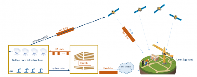 Architecture of the Galileo HAS system.
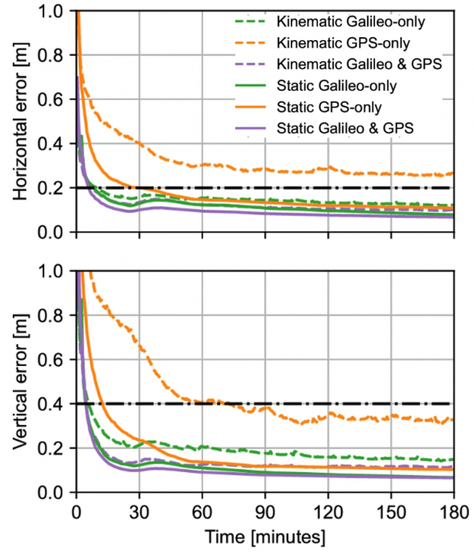
 image: Getty images

 image: the economist


.jpg?auto=webp)


