Saturday, January 3, 2015

Canada CHS update in the Marine GeoGarage

As our public viewer is not yet available
(currently under construction, upgrading to a new viewer
as Google Maps API v2 is officially no more supported),
this info is primarily intended to our universal mobile application users
(Weather 4D Android -App-in- on the PlayStore)
and also to our B2B customers which use our nautical charts layers
in their own webmapping applications through our GeoGarage API


CHS raster charts coverage

3 charts have been updated (December 29, 2014)
    • 3494 VANCOUVER HARBOUR - CENTRAL PORTION/PARTIE CENTRALE
    • 3934 APPROACHES TO/APPROACHES À SMITH SOUND AND/ET RIVERS INLET
    • 3974 DEAN CHANNEL BURKE CHANNEL AND/ET BENTINCK ARMS
      So 696 charts (1680 including sub-charts) are available in the Canada CHS layer. (see coverage)

      Note : don't forget to visit 'Notices to Mariners' published monthly and available from the Canadian Coast Guard both online or through a free hardcopy subscription service.
      This essential publication provides the latest information on changes to the aids to navigation system, as well as updates from CHS regarding CHS charts and publications.
      See also written Notices to Shipping and Navarea warnings : NOTSHIP

      Underwater illusion : amazing freedive

      A new vision of the sensations and emotions in the oceans.
      4' video winner in World ShootOut 2014 Video clip category underwater grand prix.
      Just camera tricks. No special effects by computer.
      Filmed in El Hierro, Canary Islands, Spain.


      Friday, January 2, 2015

      Could you live on this boat for a year?


      David Welsford lives on a 28-foot sailboat called Lizzy Belle that he rescued from a scrap heap. 
      With only the bare necessities, he still feels like the richest man in the world.
      Filmmaker Kevin A. Fraser offers a glimpse into Welsford’s daily routine and his musings on how life at sea has changed him.

      Thursday, January 1, 2015

      Happy New Year 2015

      Wednesday, December 31, 2014

      Barcelona World Race 2014-2015


      BWR
      : the greatest double handed ocean challenge 


      Tuesday, December 30, 2014

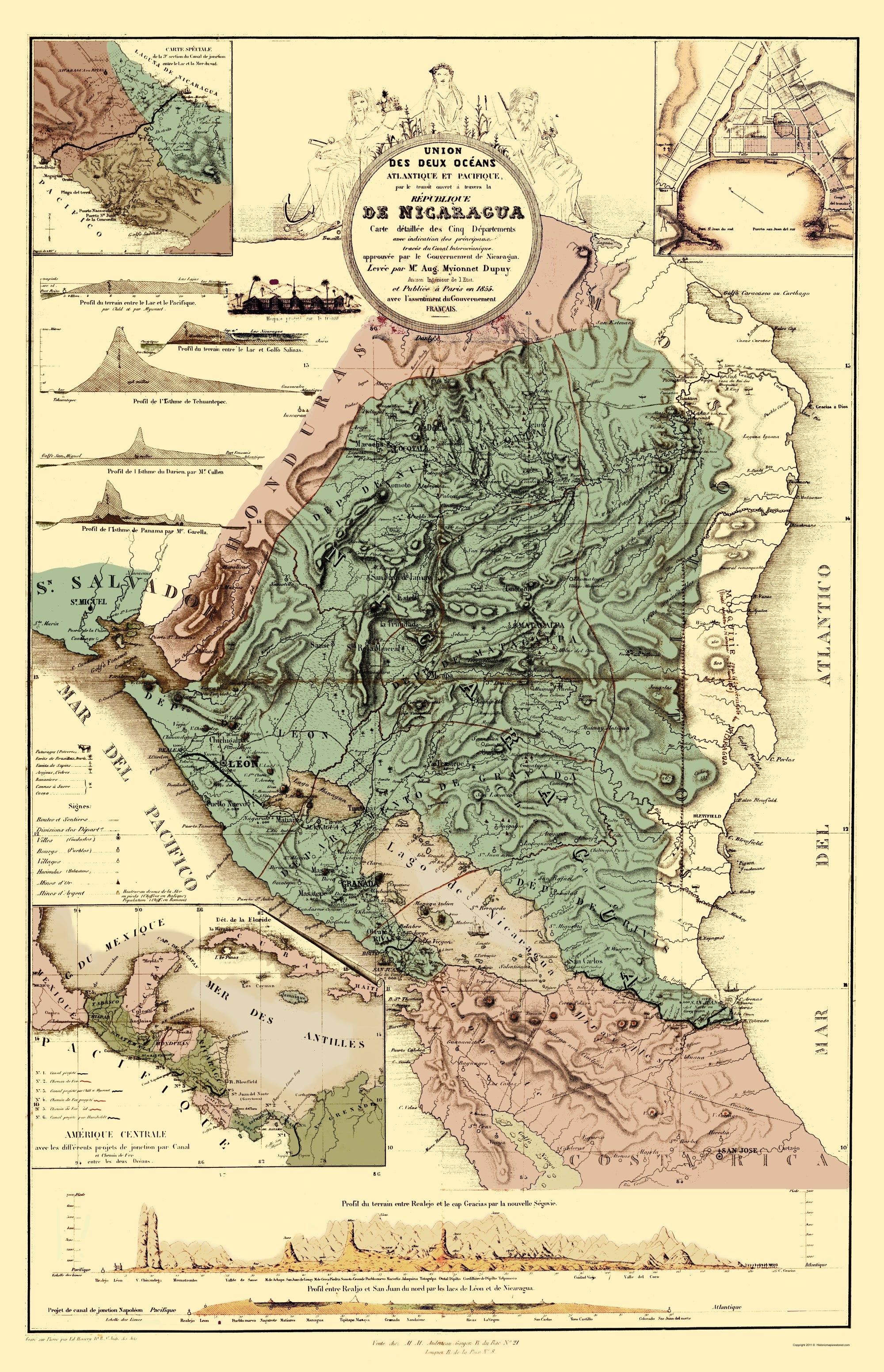
      Nicaragua launches construction of inter-oceanic canal

      The Chinese firm HKND has a contract to build the 173-mile long Nicaraguan Canal, which will connect Caribbean and the Pacific, and operate it for 50 years.

      From BBC

      Nicaragua has announced the start of work on a new canal linking the Atlantic and Pacific Oceans.

      At an opening ceremony, Wang Jing, the president of HKND, the Chinese company building the canal, said this moment would go down in history.
      The 278km (172 mile) waterway will be longer, deeper and wider than the Panama Canal.

      But critics fear a negative environmental impact and doubt its viability and economic benefits.
      The Grand Canal of Nicaragua, as it has been called, aims to rival Panama's waterway and lift the country out of poverty.

      The opening ceremony was largely symbolic, as work began on an access road for machinery needed to build a port for the canal on Nicaragua's Pacific coast.
      Nicaragua's Vice-President Omar Halleslevens said the canal would change the history and the economy of Nicaragua, one of Latin America's poorest countries.
      "With this great canal, Nicaragua expects to move 5% of the world's commerce that moves by sea, which will bring great economic benefits and double the GDP (gross domestic product),'' said Mr Halleslevens.


      Nicaragua Canal Project Overview image from HKND


      Analysis: Arturo Wallace, BBC News, Nicaragua

      There is a clear sense of expectation here, where the construction of a man made passage between the Pacific and Atlantic oceans designed to dwarf the Panama Canal has officially begun.

      But there is also tension: over the past few weeks protests against the canal have increased.
      And the authorities' decision to hold the main groundbreaking ceremony in Managua, some 120km away from where the waterway is to built, won't help convince the many sceptics who still doubt the project's viability.

      The government claims that the project, awarded to a Hong Kong based international consortium, will finally lift the Western hemisphere's second poorest country out of poverty.

      But many fear environmental damage may outweigh the economic benefit, or oppose the extremely generous terms offered to the Chinese investors.
      Those who live on the projected route simply don't want to lose their land and livelihoods.

      Nicaragua Canal topographic, Dupuy 1855


      HKND says it expects the project to be finished within five years and operational by 2020, and to cost about $50bn (£32bn).
      The project is to include two ports, an airport, a resort and an economic zone for electricity and other companies.

      But some have questioned the canal's financial soundness and allege that Wang Jing lacks experience in developing or financing big infrastructure projects.
      Opponents are also concerned about the impact construction may have on Lake Nicaragua and on poor communities in the area.
      The route announced in July would pass through the lake, an important source of fresh water.
      Environmentalists have warned of the risks of damming rivers and moving large amounts of soil. Communities along the route have staged protests.

      Links :

      • The Guardian : Protests as Nicaragua starts work on $50bn interoceanic canal
      • The Conversation : Panama Canal rival: work starts in Nicaragua amid fears over environment and role of China 
      • GeoGarage blog : Nicaragua waterway to dwarf Panama canal 

      Monday, December 29, 2014

      US NOAA update in the Marine GeoGarage

      As our public viewer is not yet available
      (currently under construction, upgrading to a new viewer
      as Google Maps API v2 is officially no more supported),
      this info is primarily intended to our universal mobile application users
      (Marine US iPhone-iPad on the Apple Store &
      Weather 4D Android -App-in- on the PlayStore)
      and also to our B2B customers which use our nautical charts layers
      in their own webmapping applications through our GeoGarage API

       NOAA raster chart coverage

      12 charts have been updated in the Marine GeoGarage
      (NOAA update December 2014, released December 22th 2014)

      • 11401 ed32 Apalachicola Bay to Cape San Blas
      • 11406 ed14 St.Marks River and approaches
      • 11408 ed30 Crystal River to Horseshoe Point;Suwannee River;Cedar Keys
      • 12325 ed5 Navesink And Shrewsbury Rivers
      • 12331 ed33 Raritan Bay and Southern Part of Arthur Kill
      • 12374 ed15 North Shore of Long Island Sound Duck Island to Madison Reef
      • 13274 ed29 Portsmouth Harbor to Boston Harbor; Merrimack River Extension
      • 16305 ed11 Bristol Bay-Cape Newenham and Hagemeister Strait
      • 17407 ed16 Northern part of Tlevak Strait and Uloa Channel
      • 17408 ed9 Central Dall Island and vicinity
      • 17409 ed11 Southern Dall Island and vicinity
      • 17431 ed12 N. end of Cordova Bay and Hetta Inlet
      Today 1026 NOAA raster charts (2168 including sub-charts) are included in the Marine GeoGarage viewer (see PDFs files)


      How do you know if you need a new nautical chart?
      See the changes in new chart editions.
      NOAA chart dates of recent Print on Demand editions

      Note : NOAA updates their nautical charts with corrections published in:
      • U.S. Coast Guard Local Notices to Mariners (LNMs),
      • National Geospatial-Intelligence Agency Notices to Mariners (NMs), and
      • Canadian Coast Guard Notices to Mariners (CNMs)
      While information provided by this Web site is intended to provide updated nautical charts, it must not be used as a substitute for the United States Coast Guard, National Geospatial-Intelligence Agency, or Canadian Coast Guard Notice to Mariner publications

      Please visit the
      NOAA's chart update service for more info or the online chart catalog

      Tsunami-hit nations mark anniversary

       Significant advances have been made in tsunami detection and forecasting
      since the Great Indian Ocean (Sumatra) Tsunami of 2004. 

      From BBC

      A decade ago, one of the largest earthquakes ever recorded struck off the coast of Indonesia, triggering a tsunami that swept away entire communities around the Indian Ocean.
      About 228,000 people were killed as a result of the 9.1 magnitude quake and the giant waves that slammed into coastlines on 26 December 2004.
      The violent upward thrust of the ocean floor at 07:58 local time (00:58 GMT) displaced billions of tonnes of seawater, which then raced towards shorelines at terrifying speeds.
      The waves stripped vegetation from mountain sides hundreds of metres inland, capsized freighters and threw boats into trees. The estimated cost of the damage was just under $10bn (£6.4bn).
      Ten years on, many coastal towns and villages have rebuilt their communities and lives. The shores of Indonesia and Thailand, left ravaged by the tsunami, appear transformed.


      How the wave spread: 26 December 2004
      After the quake struck, the resulting tsunami radiated across the Indian Ocean, from Indonesia to Sri Lanka and beyond.
      Sequence of graphics showing the spread of the 2004 Asian tsunami
      Sequence of graphics showing the spread of the 2004 Asian tsunami

      The quake ruptured the greatest fault length of any recorded, spanning a distance of an estimated 1,500km (900 miles) - longer than the US state of California.
      The rupture started beneath the quake's epicentre and progressed northward along the fault at about 2km/sec (1.2 miles/second) - lasting about 10 minutes - according to the Tectonics Observatory at the California Institute of Technology.
      The length of the rupture meant that the waves reached a wider geographical area - as far afield as Mexico, Chile, and the Arctic.
      The waves travelled at speeds of up to 800km/h (500mph).

      Map showing the arrival time of the 2004 Indian Ocean tsunami waves

      Computer modelling after the tsunami, estimated that waves had reached a height of almost 20m (65ft) in some areas.

      Map showing the wave height of the 2004 Indian Ocean tsunami

      However, scientists investigating damage in Aceh, Indonesia found subsequent evidence that waves had reached 20-30m (65-100ft) in places.
      Despite there being several hours between the earthquake and the impact of the tsunami, nearly all the victims were taken completely by surprise. With no adequate warning systems in place, there was no alert issued to people to seek safety.
      In the aftermath of the disaster, the Indian Ocean Tsunami Warning and Mitigation System was formed to detect seismological changes and provide warnings of approaching waves.
      However, on the 10th anniversary of the disaster, risk experts and UN officials have warned weaknesses remain in the system, particularly regarding the communication of warnings at local level.

      Links :
      • National Geographic : Will Indonesia be ready for the next tsunami? 
      • LiveScience : Tsunami science: Advances since the 2004 Indian ocean tragedy
      • WSJ : Tsunami’s legacy: Quest for early warning

      Sunday, December 28, 2014

      Surf sailing

      Visit Finland, an entry in the Clipper Race, surfs down at wave at 27 knots.
      Heading toward the Race 9 finish line in the Clipper Round the World Yacht Race in 2012, the Golden Gate Bridge, the Finnish team experience a huge surf after crossing the Pacific Ocean spending 30 days at sea in the race from Qingdao, China to Oakland, San Francisco Bay.