Saturday, September 7, 2019

Greta Thunberg and the lessons of the sea

The teenage climate activist Greta Thunberg sails past the Statue of Liberty on the Malizia II racing yacht in New York Harbor as she nears the completion of her trans-Atlantic crossing.
An exploration of the value of ocean crossings in small vessels in pondering the climate change challenge.
Credit Mike Segar/Reuters

From NYTimes by Andrew C. Revkin

A trans-Atlantic crossing by boat can teach us about confronting the global warming crisis.

Greta Thunberg, the 16-year-old Swedish climate activist, represents many things to many factions in the fight to slow human-driven global warming.

Some see her as a manipulated totem.
Others, as a hero.
I’m among those who see great value in Thunberg’s sharp prod to the status quo, though I see the greatest value in climate strikes pressing for global action if they are coupled with local efforts for clean-energy progress.
(Why not, for instance, call attention to the mostly-fossil-fueled boiler rooms heating and cooling schools, homes and workplaces.)

But this week, perhaps it’s worth focusing on some lessons that might be learned from her choice of transportation.
Ms. Thunberg and her father arrived in Manhattan on Wednesday after a 15-day crossing of the Atlantic from Britain as passengers on a spartan, high-tech multi-million-dollar ocean-racing yacht.

She’s here to help lead climate strikes on Sept. 20 and 27 demanding an end to the use of fossil fuels and speak in between at the United Nations Climate Action Summit and other events.

Her decision to make the trip under sail has been both hailed for highlighting low-emissions lifestyle choices and derided as showmanship.
Indeed, the aviation emissions of an army of journalists flying to cover her arrival and the summit eclipsed any savings her crossing achieved.

But there are other lessons that can be learned in an ocean crossing like hers.
I’m sure Ms. Thunberg will be changed by the experience.
I wish everyone could watch terra firma disappear as they cross a big ocean in a small boat.
The earth, after all, is itself a very small boat in the boundless ocean of space.

In 1978, when I was 22, six years older than Greta is now, I serendipitously had the chance to sign on as a crew member on a 55-foot-long, partially home-built sailboat, the Wanderlust, that was circumnavigating the planet.
I was in the South Pacific, having won a modest post-college traveling fellowship to visit small islands and study, yes, “man’s relationship to the sea.”

A “crew wanted” sign on a wharf along the harbor in Auckland, New Zealand, led me to the vessel, which hailed from Sacramento and consisted of an unusual ferrocement hull (cement smeared on a steel frame) and an equally odd assortment of fittings.
The mast was a surplus highway light pole.

The author on board the Wanderlust in the Red Sea in 1980.

I left the boat 17 months, 15,000 miles, 15 countries and several close calls later, in what was then Yugoslavia.
The intervening experiences shifted my career ambition from marine biology to environmental journalism.
Here’s a bit of what I learned, lessons that seem applicable to efforts to build wider momentum behind cutting greenhouse gas emissions and reducing climate risks.

Tight quarters require compromise.

Our first long crossing, from Auckland to Sydney, Australia, was the stormiest.
We spent eight out of 11 days on the Tasman Sea pounding into chaotic gale-driven seas.
Without GPS or an autopilot, we had taken on extra crew members to handle the night watches.
In cramped conditions day after day, everyone aboard felt unfairly overtaxed.
But you learn to smooth rough edges, tamp hard feelings and not hoard the Hershey bars.
Despite a no-smoking rule, the skipper, Lon Bubeck, even allowed the two chain smoking New Zealanders to light up — in the inflatable dinghy trailing behind.

This gets to my first point.
In hashing out climate policy, accommodation is vital among those who have the same goal but differ on how to reach it.
I’m thinking here, for instance, of clean energy advocates who disagree about the role of nuclear power in reducing emissions.
It’s vital to acknowledge the inevitability, even desirability, of having a diversity of climate solutions.

Panic doesn’t help.

When a rogue wave blew in a porthole crossing the Tasman, a piston-like column of green water blasted in every few seconds.
A similar porthole incident happened more than a year later in the Red Sea.
Each time, the skipper, who had spent years as a handyman in Santa Cruz, Calif., had an astonishing ability to assess the situation, identify a fix and hand out orders.
When his calm demeanor caught my attention, I stopped flailing around and focused on my task.

Which gets to my second point.
Many pressing for a Green New Deal of any sort have tried changing the global warming hashtag from #climatechange to #climateemergency.
Whatever you call this moment, it took more than a century for the world to become dependent on fossil fuels and, as the Paris Agreement on climate change recognized and Axios just reported, it will take decades to move the global economy to clean energy and cut or collect tens of billions of tons of annual emissions of carbon dioxide.
Urgency has to be blended with patience.

Vastness has limits.

I still meet people who insist that the human influence on the vastness of the atmosphere and oceans is inconsequential.
At sea, I experienced the full sense of the size and depth of the oceans when we were becalmed for several days halfway across the western Indian Ocean.
To cool off, wash and pass the time we went swimming — in water 14,300 feet deep.
I still get a cold chill when I recall looking down through my face mask at the vanishing points of my shadow and the Wanderlust’s bobbing a few hundred feet away.

But vastness has limits.
Long before today’s “planet or plastic” campaigns, we encountered jarring evidence of the activities of man even on isolated island beaches that rarely saw a footprint.
Anchoring off a remote beach on Mount Adolphus Island in the Torres Strait between Australia’s Cape York and Papua New Guinea, we collected a dizzying array of plastic flotsam — mostly lost or tossed fishing gear.
In 1980, transiting the Red Sea, we sheltered from gale winds in the lee of an uninhabited island off the coast of Yemen.
I hiked to the windblown southern shore and stumbled into tide-tossed heaps of light bulbs of all sorts.

With the atmosphere, humans could be perceived as a minuscule influence, having raised levels of heat-trapping carbon dioxide from only 280 to 410 parts per million since the Industrial Revolution.
But that increase has had an outsize influence on the global thermostat.
It’s been three million years since the planet last hit that concentration and we’re on the path toward doubling preindustrial carbon dioxide within decades.

Vastness can deceive.

You can’t run away.

On a fateful night heading through the Gulf of Patras in Greece toward the Adriatic, I was alone at the wheel, with everyone else asleep below, as a violent gale built behind us.
I was unsure whether to keep the lighted buoy ahead to port or starboard.
I guessed wrong and we ended up aground on a sandbar, pounded by ferocious waves.

The Wanderlust being repaired in Patras, Greece, in 1980.
Credit Andrew Revkin

We were towed to safety, spent a month repairing the cracked cement hull, nervously relaunched and sailed on.
The cracks did not re-form.
But I was slowly realizing that I needed to get home to build a career.
Decades later, those powerful memories and lessons from life at sea still shape my life and how I view the path ahead.

Greta Thunberg’s journey so far has had a rocket-like trajectory.
Her voice and those of other young climate activists deserve amplification.
They represent generations who will inherit the climate we’re shaping today.

But the task of building a sustainable relationship with the climate requires all of us to push off from comfortable shores, respect (if not embrace) the diversity of views of fellow passengers, share our vessel’s finite resources and — most important — avoid panic and get down to work.

Links :


Friday, September 6, 2019

Grounding: achieving the right mix of visual and electronic navigation


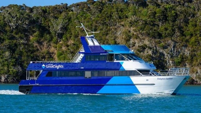
The Fullers GreatSights vessel Dolphin Seeker struck Brampton Reef during a dolphin-spotting trip.
Photo / supplied Northern Advocate
From The Maritime Executive

New Zealand's Transport Accident Investigation Commission has released its report into the grounding of the Dolphin Seeker in October 2018 noting the skipper was effectively working alone in a high-risk situation and not making adequate use of electronic navigation aids.

 Excerpt of chart of the Bay of Islands showing the afternoon voyage of the Dolphin Seeker

The restricted-limits passenger catamaran Dolphin Seeker was on her second dolphin-watching tourist trip of the day in the Bay of Islands, with six crew and 47 passengers on board.
The skipper had located a pod of dolphins near the Brampton Bank area and was maneuvering the Dolphin Seeker to stay with the pod, at the same time as giving a commentary over the public address system, when the vessel ran aground on rocks at slow speed.
Nobody was injured, but the vessel sustained significant damage to both propellers and minor damage to its hull.
The passengers were transferred to another company vessel.
The Dolphin Seeker was re-floated on the rising tide and towed back to her berth.

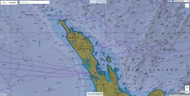
 Brampton Bank with the GeoGarage platform (Linz nautical chart)

Lcation of the grounding

The Commission found that the grounding occurred because the skipper did not notice that the vessel had moved into shallow waters while focusing on giving a passenger commentary at the same time as maneuvering the vessel to maintain proximity to the pod of dolphins.
The Commission also found that the skipper was effectively working alone in a high-risk situation.

There were few or no defenses in place to prevent the one-person errors that resulted in the
 grounding, such as fully utilizing the features of the vessel’s electronic navigation equipment.
The report states that the skipper was competent in using the electronic navigation aids on the Dolphin Seeker, and they were switched on and available for immediate use.
However, the skipper did not routinely use them to full effect and neither did some of the operator’s other skippers.

 The Dolphin Seeker

One reason for this was that most operations were tourism based and only occurred in good weather.
The skippers were fully familiar with the Bay of Islands area, and they usually navigated visually.
“A key component of using electronic navigation aids effectively is that the users must be fully current and practiced in their use so that they can seamlessly switch back and forth between visual and electronic navigation.
That ability depends on their routine and frequent use of the equipment, and the equipment being set up for the conditions at the time,” states the report.

There were at least two available features of electronic navigation equipment that could have been used to improve navigation safety, and either would likely have prevented this grounding:
  • the chart plotter could have been used to effectively geo-fence hazards such as the rocks. Due to the repetitive nature of the Dolphin Seeker’s mission, and the common equipment across the fleet, it would be achievable to geo-fence most navigational hazards within the Bay of Islands
  • the depth sounder could have had an alarm set to alert the skipper when the vessel moved into shallow water.
The Commission has raised the issue of ineffective or improper use of electronic navigation aids in two other recent inquiries.
In one case the electronic navigation aids were not configured correctly for immediate use.
In both cases the alarms were either not set or silenced, or were noticed by the crew and not acted on.

Links :

Thursday, September 5, 2019

World's largest yacht launched: the 183m REV Ocean


The REV Ocean research and expedition vessel was launched on August 24th at the VARD Tulcea shipyard in Romania.
It will now begin its journey to the VARD shipyard in Brattvag Norway for additional construction and outfitting.

From SuperYachtTimes by Laura Nicholls 

After days of preparation, the 182.9-metre 17,440GT yacht Research Expedition Vessel (REV Ocean) has been launched in Tulcea, Romania.
Built by commercial shipbuilder VARD, REV Ocean was designed by Espen Oeino for expedition activities carried out by marine experts and researchers.

photo : Bogdan Vasilescu

photo : Bogdan Vasilescu

In research mode, she can carry up to 60 scientists and 30 crew members or up to 36 guests and 54 crew if being used for luxury expeditions.
H2 Yacht Design has designed the interiors of the explorer yacht.

photo : Bogdan Vasilescu

George Gill, Project Director and Owners Representative, said:
“It is an emotive experience launching REV. To have developed and overseen REV from a blank piece of paper three and half years ago has been a challenging, educational, rewarding experience, the project evolved into something far more complicated and ambitious than I ever assumed and it has been a personal career highlight. Our Build Team, VARD Group and our Partners have worked and are working incredibly hard realising Mr Kjell Inge Røkkes wishes to create this amazing vessel. We still have a long way to go and a lot of hard graft ahead, but I cannot wait to get her to Norway and start the next phase. REV will be a truly inspiring vessel in looks and purpose when we deliver her to REV Ocean”.

photos : Bogdan Vasilescu

Performance-wise, 4x Wärtsilä 8L26 2.7 MW ea engines will enable REV Ocean to reach a maximum speed of 17.8 knots.
Also with a dynamic positioning system, she can reach a range of 21,120 nautical miles when travelling at 11 knots - which is enough to cover the equivalent of 98% of the distance around Earth.

photos : Bogdan Vasilescu

With SuperYacht Times having followed the construction of REV Ocean since the contract was first announced in early 2017, REV Ocean will now be transported to the VARD shipyard in Brattvag, Norway, where she will remain for up to eight months for outfitting.
Final completion is scheduled to happen in Germany, where she will be delivered during the first quarter of 2021.


photo : Bogdan Vasilescu
Project REV meets the beautiful Istanbul and Bosphorus..

Links :

Wednesday, September 4, 2019

The country disppearing under rising tides


From BBC by William Park

Rising sea levels are making traditional ways of life impossible. Rural Bangladeshis are having to adapt to survive.


Bangladesh has been a vulnerable state for much of its short existence.
People in this flood-prone country have coped with rising water levels with a combination of innovation, flexibility and resilience – but the extremes the environment is now throwing at them might be beyond anyone’s endurance.

As climate change accelerates, the pressures on rural Bangladeshis mount.
Where previously people might have been able to move away for the worst of seasonal flooding, the regularity of waterlogging is making it impossible to farm.
Crop varieties cannot cope with the saltwater, and career alternatives are limited.

What, then, can be done for the most vulnerable people; the rural rice farmers of Bangladesh?


A family navigate the heavily flooded land around their slum, Korail, in Dhaka, the capital city of Bangladesh (Credit: Ignacio Marin/ Institute)

Historically, people in Bangladesh had worked around seasonal flooding; farming for part of the year and retreating when water levels rose, or seeking work in the cities as land became unusable.

By the end of the century, however, sea levels are expected to rise along the Bangladesh coastline by up to 1.5m.
And that will come with more extreme seasonal fluctuations in sea levels. Disastrous storms and unusually high tides currently occur once each decade, but could become as regular as three to 15 times each year by 2100.

As a result, rural Bangladeshis face a stark choice; change their way or life or seek employment and a home elsewhere.

“The climate is becoming more volatile so we are seeing higher frequency of migration,” says Joyce Chen, an economist at The Ohio State University.
“Where in the past we see migration due to annual flooding, or river bank erosion, now we see saltwater intrusion more commonly which affects the environment long term. It makes it harder to grow crops because the land is permanently altered by the saline water.”
In the past, he says, people could go to work in the city for a few months while the land was flooded and return when the flood had retreated. Now that is no longer possible.
“People realise it is not viable to stay.”


Fishing nets have replaced rice pickers in much of rural Bangladesh
(Credit: Ignacio Marin/ Institute)

For some, the saltwater offers an opportunity.
Where rice might have once grown, shrimp farms are taking over – the saltwater providing the right environment to switch to aquaculture.

“When we look at people converting from agricultural production, households seem to maintain their production pretty well by switching to aquaculture,” says Chen.
“They seem pretty resilient. But, the ways they are being resilient now need to be sustainable into the future. How sustainable will aquaculture be? If enough people convert and there is too much saline intrusion that could create new problems and distort the economy in ways people cannot predict.”


Villagers work to repair an artificial embankment that protects their land from saltwater intrusion (Credit: Ignacio Marin/ Institute)

The art of re-routing water using earth walls to create artificial islands for farming is perhaps best-known as a Dutch initiative.
People in Bangladesh have also taken to building polders, as they are known, to protect their farm land.
However, tensions arise when some farmers want to protect their agricultural land, on which they are growing rice, from saltwater intrusion while neighbouring farmers might inundate their land with saltwater in order to start farming shrimp.

“Anecdotes suggest that building sea walls and structures to keep the seawater out may be creating problems more than helping in that it creates conflict,” says Chen.
“There are groups that want to allow more saltwater in to convert from agriculture to aquaculture. It benefits those that want to convert but not everyone is doing so. The seawater and levees allow more control which in some cases worsens the salinity problem.”


The pressure to switch to aquaculture is leading to conflict between farmers and fishermen
(Credit: Ignacio Marin/ Institute)

Chen says there may now be 100,000 people migrating each year due to saltwater flooding, but it is hard to estimate accurately because the changing wider economy is also affecting migration.
A strong economy in India attracts workers, too, who often seek construction or agricultural work.

Mobile phones are one way to keep track of where people are moving, Chen has found.
There are around 145m Sim card connections in Bangladesh, accounting for 87% of the population, although people change sim cards often and some people keep multiple phones.
The high penetration of mobiles in Bangladesh is due to much of the population being reliant on them for banking.
Mobile banking allows one person to work in a city as a migrant sending money home. Previously you might have had to wait several months for them to return with cash.

Bangladeshis are facing a choice; whether to migrate to find work in cities or change their way of life (Credit: Ignacio Marin/ Institute)

“We see both types of migration going on in Bangladesh – better opportunities in cities attracting workers or, in the case of climate change, they are moving because changes in the environment are making it hard to make ends meet,” says Chen.

As a low-lying country, Bangladesh has always been a vulnerable area to changing sea levels, so adapting and migrating are not unusual demands.
Chen says people in Bangladesh are on a good path of economic growth at the moment, but the volatile climate makes it hard to predict whether this growth will continue.

A villager stands in front of bamboo canes which will be used in construction
(Credit: Ignacio Marin/ Institute)

Some Bangladeshis have tried to adapt their crops to the new conditions, but with limited success.
“We have heard a little about switching to types of crops that are more saline-tolerant but I don't think there are that many varieties that exist,” says Chen.

Researchers in China have suggested that they have developed saltwater-resistant strains of rice, but there is little peer-reviewed evidence that these strains are viable, and the water in which the crops were tested contained only 10% the concentration of salt found in seawater.

Most migrants who head to Dhaka end up in slums similar to this one
(Credit: Ignacio Marin/ Institute)

Migrants moving within Bangladesh are attracted to the larger cities which for the most part are on the coast.
Chen warns that this still leaves many people vulnerable to the effects of rising sea levels. Those cities might become uninhabitable with rising tides and could result in many thousands of people needing to find homes elsewhere all at the same time.

Alternatively, some rural Bangladeshis are adapting their homes.
“I have heard stories of a lot more people building their houses on stilts, or having retention ponds around farms,” says Chen.
“I have heard some stories of schools moving onto boats so they can continue operating after flooding.”

Migrants from rural Bangladesh often have to take low-paid work, like sorting through plastic waste, when they reach the cities
(Credit: Ignacio Marin/ Institute)

Some migrants seeking work in Bangladesh’s cities find themselves picking through other people’s waste. Children and families can earn money by picking out recyclables.
Large quantities of plastic waste, for example, wash into cities in flood water.
The labour is hard, and the returns are small, but many workers might be faced with few alternatives.

Workers load recyclable plastic into a mill for processing
(Credit: Ignacio Marin/ Institute)

With few opportunities facing unskilled labourers, finding work when reaching a new city can be hard. One problem facing those responsible for protecting migrant workers in Bangladesh is that those who are most vulnerable are the least able to relocate, Chen warns.

“The most vulnerable people might be stuck in place, says Chen. “People with greater means will be able to move out of vulnerable areas, but those worst affected might be stuck.”

“It will be hard to address the needs of those folks.”

A child looks over the polluted Buriganga river that flows through slums in southwest Dhaka
(Credit: Ignacio Marin/ Institute)

For Chen, the next project involves looking at how migration is affecting the lives of the most vulnerable people in society – children.
"There is some evidence that migration due to saline water inundation affects educational outcomes, food insecurity affects health, too,” says Chen.

For many, food insecurities result in a trade-off between personal health and the welfare of their livestock – some of the most valuable assets rural families own.
“People talk constantly about how hard it is to get fresh water in Bangladesh – they call it sweet water,” says Chen.
“And they have to save the sweet water for their livestock.”

While scientists might develop saltwater-resistant crops in time, and some Bangladeshis will find work in aquaculture, the more immediate concerns of health and safety – of survival – are a big motivator for migrants in Bangladesh.
People will go where the water tastes sweetest.

Links :

Tuesday, September 3, 2019

This radar image highlights the growth of the small satellite industry

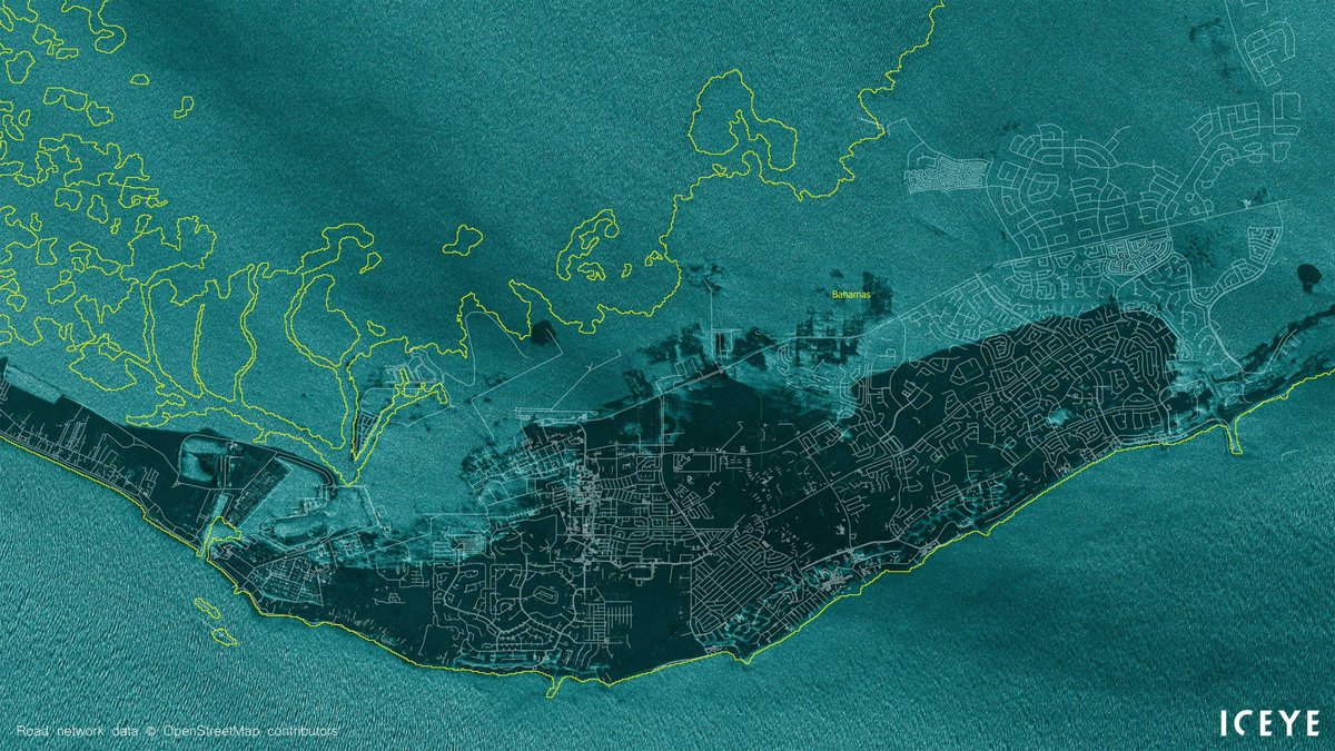
Hurricane Dorian has affected Bahamas heavily on Monday, with vast areas hit with flooding, including the Grand Bahama International Airport, Freeport. 
ICEYE AR satellite image from 11:44AM local time

Nautical chart upon Google satellite imgary with the GeoGarage platform

From Forbes by Alex Knapp

On Friday, Finland-based imaging satellite startup Iceye announced that it’s now capable of producing radar images with a resolution of less than one meter.
This is a major milestone for the company, which launched its first satellite in January 2018, and also highlights the growing sophistication of the small satellite industry, particularly in the area of remote sensing.

SAR image from Iceye showing a highway intersection in Mozambique.
This is done with their own constellation of micro satellites equipped the unique synthetic-aperture radar instruments developed and made in-house by the company.

ICEYE SAR satellite constellation imaging is not limited by weather conditions or by the need for sunlight.

Iceye, which now operates three satellites, doesn’t take images with a camera.
Instead, it uses synthetic aperture radar (SAR), a technique that uses satellite flight paths to simulate a large radar antenna.
The resulting images provide data of interest to a wide variety of customers, ranging from oil and gas companies to emergency responders.
The information is especially useful because it can be gathered no matter the weather—the process of gathering SAR images ignores clouds, which often obscure traditional satellite visuals.

For Iceye, the ability to get those SAR images to resolutions of less than a meter is “one more milestone achievement, effectively pushing through the boundaries of capabilities you might not have thought you could reach with a small satellite,” says Pekka Laurila, the company’s cofounder and chief strategy officer.

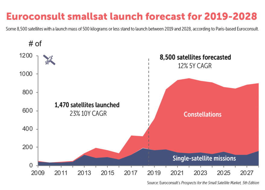
Iceye is one of several satellite imaging companies founded earlier this decade that took advantage of the miniaturization of technology to create satellites that are much smaller than traditional imaging satellites.
Its satellites are about 9 feet long and 150 pounds, compared to larger communications satellites that can be the size of a small car.

Comparison of two satellite images of the same Nigerian port, one with the Sentinel-2 imaging satellite and one with Iceye's SAR.
ICEYE

Although those larger satellites, which are typically in sun synchronous orbit, can typically achieve higher resolutions than smaller satellites, the latter have the advantage of being able to be deployed more quickly and in lower orbits, meaning that parts of the planet can be revisited on a more regular basis—sometimes as often as twice a day.
As Friday’s announcement shows, smaller satellites are catching up on image quality as well.
And because they’re less expensive and can be deployed more quickly, they’re easier to scale to the market.

“What’s new about small satellites is you can be extremely reactive, you can maintain exactly the number of satellites that there’s demand for at any given point,” says Laurila.


In 2018, revenues for companies providing data from remote sensing satellites, which includes imaging satellites as well as satellites that are capable of tracking other surface activities such as ship movements or weather patterns, exceeded $2 billion, according to a report from Bryce Space and Technology.

Investors are paying attention to this market, too. Iceye has raised about $53 million in capital and grant money to date.
Virginia-based Hawkeye 360, which tracks radio signals for maritime, defense and other applications, announced it had raised a $70 million series B round earlier this week.
San Francisco-based Planet is estimated to be a unicorn, with over $770 million raised and a valuation of $2.2 billion, according to Pitchbook.

Although Laurila says the company is likely to pursue another round of venture capital in order to accelerate growth, he says that there’s already enough market demand to enable Iceye to build a sustainable business model and “generate recurring revenue.”
The company has a wide range of customers, and it has entered into a number of partnerships, including a recently announced one with the European Space Agency.
“There’s an established and existing market of users that really demand radar imagery,” he says.

Links :

Monday, September 2, 2019

Why the track forecast for hurricane Dorian has been so challenging


From Forbes by Marshall Shepherd

Here is something that you can take to the bank.
We will not see the name "Dorian" used in the Atlantic basin for any future hurricane.
The names of particularly destructive or impactful storms are retired.

Seas warmer than 27.8°C (82°F) are generally considered hurricane fuel.  
HurricaneDorian is now at Category 3 strength.
Although the route of Dorian is uncertain, one thing is for sure: it has plenty of warm water on any path it takes.

According to the National Hurricane Center, Dorian is now tied with the 1935 Labor Day hurricane for the strongest Atlantic hurricane landfall on record. In a 3 pm advisory on September 1st, the National Hurricane Center warned of gusts to 220 mph and 18 to 23 feet storm surges for parts of the Abacos.


I have been in the field of meteorology over 25 years and do not recall seeing warnings about 220 mph gusts for a hurricane.
Hurricane watches have also been issued for Andros Island and from North of Deerfield Beach to the Volusia/Brevard County Line in Florida. At the time of writing, the official forecast from the National Hurricane Center is for a northward curve and no direct Florida landfall.


Hurricane Dorian putting on a lightning show tonight Aug 30th. 
Spectacular imagery.
source Dakota Smith

This is dramatically different from forecasts only a few days ago.
There is still uncertainty with the forecast so coastal Florida, Georgia, and the Carolinas should remain on high alert.
Why has the track forecast been so challenging with Hurricane Dorian?

Hurricane Dorian approaching the Abaco
NOAA/CIMSS

Historically, hurricane track forecasts have outpaced intensity forecasts.
I discuss the reasons why in a previous Forbes article at this link. With Hurricane Dorian, uncertainty about the forecast track and timing of the storm forced officials to move the Florida State - Boise State football game from Jacksonville, slated for a 7 pm kickoff on Saturday, to noon in Tallahassee.
I am certain that many businesses and people are questioning the move given that timing of when impacts are now expected.
Unfortunately, officials and emergency managers often must make decision on the best information at the moment.

Some people may be tempted to use uncertainty with this forecast to spew vitriol or skepticism at meteorologists and our models.
However, challenges with Hurricane Dorian's track forecast do not define the legacy of weather forecasts.
It would be silly to say that the NFL's best field goal kicker is terrible based on a few misses.

 NOAA's GOES-East took this image of Hurricane Dorian the evening of September 1, 2019.
see animation

So what's going on? I asked a panel of tropical meteorology experts.

Speed of motion of Hurricane Dorian has been a significant challenge.
Before you bash the meteorologists for being stupid: one reason the forecasted track has changed is because the forecasts of the forward speed of Dorian have slowed it down more and more.
If it had chugged along as originally forecast, it likely would have hit east-central Florida and then maybe gone into the Gulf, before the high pressure above us in the Southeast would break down.
But, because it's moving more slowly, the high-pressure break down is opening the gate, so to speak, for Dorian to go more northward and eastward.
So, the change in forecast is tied tightly to the arrival timing.
He wrote:
the ridge to the north of Dorian has been steering Dorian off to the west the last few days....But there is a weak trough that is swinging into the eastern US that is going to erode the strength to the ridge enough so that a gap forms to the north of Dorian and it begins to move further to the north.
The timing of when that weakness develops and on how far Dorian makes it west in the meantime has been the source of uncertainty in the model guidance for the last 2-3 days according to Papin.
At the time of writing, there is still some spread in the model solutions.

Interaction of high pressure ridging with Hurricane Dorian
Philippe Papin

Dr. Michael Ventrice is a tropical weather expert with IBM and The Weather Company.He has been concerned about the storm environment and how well the models are capturing the rapidly evolving situation.
He told me:
I believe the uncertainty is derived from how the models are resolving Dorian, locally.
The recent intensification of the storm today is not being resolved by the models properly at the time of the 12z initialization.
The interaction with the Bahamas, how that interaction might alter the mesoscale structure of the Hurricane, if that interaction induces a wobble, are all valid questions at this point in time
Michael Ventrice — IBM/The Weather Company

A hurricane of this size and intensity can certainly modify its environment and be modified by that environment.
Sam Lillo, a doctoral candidate at the University of Oklahoma, tweeted an interesting point on the afternoon of September 1st about how worrisome the rapid intensification and track uncertainty of Hurricane Dorian has been:
The track uncertainty in NWP at under 3-day lead-time is very uncomfortable, especially considering proximity to land. This would be uncomfortable for any hurricane. But then make it a category 5.
Sam Lillo, doctoral candidate in meteorology at the University of Oklahoma
 Following hurricane Dorian through wave height
Hurricane Dorian, the most powerful hurricane to hit an Atlantic island on record - projected significant wave height of 11.2 metres by September 5th, from Copernicus Marine Service Waves model.

Our best models have oscillated (and in some cases continue to do so) within the past 24-36 hours on just how close Dorian will get to Florida before curving northward.
Lillo offers some further insight into what Dr. Ventrice was alluding to about the environment:
As Dorian strengthened faster than expected, diabatic outflow developed an upper level anticyclone to the southwest, adding southerly and westerly components to the steering flow.
The westerly component in particular slowed the forward motion of the hurricane, and now its track across the Bahamas coincides with a trough that sweeps across the Mid Atlantic and Northeast on Monday.
This trough cuts into the ridge to the north of Dorian, with multiple steering currents now trying to tug the hurricane in all different directions.
The future track is highly sensitive to each of these currents, with large feedback on every mile the hurricane jogs to the left or right over the next 24 to 48 hours.
Sam Lillo, doctoral candidate in meteorology at the University of Oklahoma
Lillo offers a nice meteorological explanation.
In a nutshell, he is saying that the rapid intensification perturbed the near-storm environment and now there may be other steering influences besides the ridge of high pressure that the models are struggling to resolve.

In a previous Forbes piece last week, I mentioned that forecasts in the 5+ day window and beyond can have errors of 200 miles and that the information should be used as "guidance" not "Gospel." Because there is still uncertainty with the models and Dorian is such a strong storm, residents from coastal Florida to the Carolinas must pay attention and be prepared to act.
I have complete confidence in my colleagues at the National Hurricane Center, and they should always be your definitive source with storms like this.
They still maintain an eventual curve northward before the storm reaches the Florida coast.
However, the issuance of hurricane watches in Florida also indicates that they know the margin of error is razor thin.


Links :

Sunday, September 1, 2019

The Balmain bug: historic six foot skiff

'Too much sail and not enough boat' is the unwritten axiom that has underpinned the development of the famous Sydney Harbour skiffs for more than 130 years.
And never was that maxim more true than for the smallest of the historic skiffs, the tiny 6 footer sometimes known as The Balmain Bug.
Look out for the full story in Yachting World's 'Extraordinary Boat' series in the July 2017 issue.