Saturday, September 22, 2012

Free wheeling


'Creating the Spectacle!' is a ground breaking series of live art and film events that record an underwater wheelchair as it flies through the water with its human occupant. 

In 'Part I - Finding Freedom', The underwater wheelchair enables Sue Austin to go on a gentle, dream like exploration of an exotic underwater world.
Through unexpected juxtapositions, this work aims to excite and inspire by creating images that transform preconceptions.

See 'Part II - Finding the Flame' on : http://wearefreewheeling.co.uk

Friday, September 21, 2012

Artwork shines light on satellite imagery

Andreas Gursky is exhibiting a new photo series “Ocean",
pursueing his play on photography’s claim for the depiction of reality.
In his six-part series Ocean I-VI (2009-2010), Gursky used high-definition satellite photographs
which he augmented from various picture sources on the Internet.

From Stuff

An international artwork described as defining New Zealand's place in the world, the large-scale photograph Ocean III by contemporary German artist Andreas Gursky will take its place in the Auckland Art Gallery's public collection this weekend.
It will be the first of his pieces to enter a public collection in New Zealand.

Ocean III is a view of the Pacific Ocean that measures 4.5m long and 2.5m high.
It is the largest in a series of six photographs - one of two featuring New Zealand.
Gursky worked with high-definition satellite photographs that normally focus on the earth's landmasses.
Due to the absence of adequate mapping of the world's oceans, he recreated ocean zones himself after consulting shoal maps.

Extended Ocean, 2011
A image from Andreas Gursky's Ocean series, with white area added to the sides of the image and then put through Content-Aware Fill 
According to the exhibition text: "In their darkly nuanced surfaces, he has worked to reconcile the division between the machine eye and the human eye, continuing the debates and practices begun in the nineteenth century regarding photography and the issue of artistic expression versus objective science."

Gallery director Chris Saines says Gursky is a "giant in the contemporary art world".
"We are tremendously excited to be able to represent the work of such an important
international artist, even more so given the particular nature of its subject, which in one way serves to represent our place in the Pacific like no other work in a New Zealand public collection.

Gursky used high-definition satellite photographs which he augmented from various picture sources on the Internet.
The satellite photos are restricted however to exposures of sharply contoured land masses.
Consequently the transitional zones between land and water – as well as the oceans themselves – had to be generated completely by artificial means.
At second glance one realises however that Gursky’s interest in the image is not cartographic in nature.
The distances between the continents do not follow any systematic programme, such as “Google Earth” offers, but are slightly shortened or elongated according to compositional principles.

"The subject of Ocean III deals with a core strand of interest to New Zealand and Pacific audiences and artists - that great expanse of ocean that defines our position in the world. It features the islands of New Zealand at the edge of a seeming blue abyss. It is a remarkable reminder of our Oceanic and Pacific location, and a fascinating realisation of how great that limitless ocean around us really is".

Links :
  • TheGuardian :  How Google and Apple's digital mapping is mapping us

Thursday, September 20, 2012

Speeding up science

   
Speeding Up Science from Facebook Stories
Watch how ichthyologist Brian Sidlauskas harnessed the power of the Facebook community to identify more than 5,000 species of fish in 24 hours.
Desperate times call for social measures.

In January 2011, Oregon State University ichthyologist Brian Sidlauskas led a research expedition into the little-known Cuyuni River region of Guyana in South America.

>>> geolocalization with the Marine GeoGarage <<<

His team documented more than 5,000 fish, but Guyana’s immigration policies required them to identify and catalog every specimen they wanted to bring back—a nearly impossible task, especially on a tight schedule.

Sidlauskas uploaded his research photos to Facebook and tagged members of the scientific community who were able to identify almost all of the photos in under 24 hours.

Species richness – the number of distinct evolutionary lineages – is a fundamental measure of overall biodiversity.
Species are basic structural and functional units of ecology and evolution.
Accurate species identification is necessary to document genetic, physiological, and ecological aspects of biodiversity.
Recognizing and naming species matters, no matter how subtle the differences may seem to the human eye. (Fishes of the Fitzcarrald)

Links :
  •  Seafloor Explorer is a crowd-sourced effort to identify species and ground cover in images of the seafloor. The application presents an image of the seafloor and asks the user to identify the ground cover and any species that are present in the image. The crowd-sourced results will then help create a library of seafloor life in the habitats along the northeast continental shelf. When the user has finished classifying the species in the image a still satellite image from Google Maps / Google Earth is displayed showing the location of the section of sea floor that has just been classified.

Wednesday, September 19, 2012

Daredevil photographers brave boiling waters to capture the drama of searing-hot lava crashing into the seas off Hawaii


Video of the first ever lava surf photography.
Taken on may 9th-16th at a Kalapana ocean entry that has just covered the last of the sand beach in the area. I waited over 5 years to get the conditions for this shot.
Then we got 3 days in the water prior to the beach getting covered.

From DailyMail

Two photographers risked their lives to become the first people to capture the explosive moment fiery lava crashes into the sea.
Nick Selway, 28, and CJ Kale, 35, braved baking hot 110F waters to capture these images, as they floated just feet from scalding heat and floating lava bombs (video)
The pair, who chase the lava as it flows from Kilauea through Kalapana, Hawaii, spend their days camped on the edge of active volcanoes to capture the incredible images.

Nature's fury: Nick Selway, 28, and CJ Kale, 35, braved baking hot 110F waters to capture these images, as they floated just feet from scalding heat and floating lava bombs

Contrast: The bright light of the lava, accentuated by a long exposure, sets of the grey of the water in the Hawaiian dusk

Terrifying: Mr Selway and Mr Kale dress only in swimming shorts and flippers as they float in rough seas as hot as 110F to capture the incredible images

Close call: The cameraman is just a few dozen feet from fiery lava pouring out of the rock
One of the daredevils braving surf, which is warmed by the lava, to snap the amazing images 

Hot and steamy: The two men use protective casings for their cameras, known as surf housings, to keep them operating in the exreme conditions

Using a simple protective casing around their cameras, and wearing just swimming shorts and flippers, they bob up and down with the water as the surf washes over their heads.
But their remarkable day jobs don't come without enormous danger.
Last year Mr Kale tumbled 20ft into a lava-tube with 40lb of camera gear on his back, shattering his ankle. Others have died in the area due to land falling away.

Beautiful, but dangerous: Mr Selway and Mr Kale don't recommend that others attempt to recreate the incredible shots

Beauty: Hawaii is an collection of volcanic islands located over a geological 'hot spot' in the Central Pacific

Hot stuff

Hot stuff
Artistic: Like a Salvador Dali painting, thick gloopy lava folds over a rock, left, as the molten rock cascades into the sea, right - causing steam to rise from the water

Magma: Mr Kale and Mr Selway spend days camped out on the edge of volcanoes to capture their shots at just the right moment

Daily drama: There are currently three active volcanoes in Hawaii

Dangerous work: One of the snappers captures an explosion
Brave: A photographer stands with his camera just a few hundreds yards from an explosion, left, as a river of lava boils down the mountainside, right

Steam: Lava flows from the volcanic island into the water

Bursts of colour: The indigenous culture of Hawaii is based around their life beside the active volcanoes

Boom: A lava bomb explodes as it hits the cold sea

Glowing: Magma pools as an explosion erupts in the background
Colourful: Several different striking hues are on display in one of nature's greatest phenomenons - including grey, blue and red (left), and orange and purple (right)

Mr Kale, from Hawaii, said: 'We shoot pictures all over the world but our volcano images are shot here on the island because it's so spectacular.
'Our days are spent on the edge of volcanoes, either leaving at midnight to get out before the light of the rising sun or hiking in the day and then staying overnight.
'We use surf-housing which is a protective case so we can venture into the water with our cameras, as the heat and water would be too much for them.
'It's 110F where we were and just 20ft in front of us it was boiling.
'We have a lot of fun but it's extremely dangerous and I wouldn't recommend anyone trying it for themselves.
'I fell into a lava-tube shattering my ankle. After climbing out we had to lash my foot to my leg with a tripod, camera strap and belt and hike over the rugged terrain for two miles.
'Not many people die each year but when they do it's normally in large groups when large chunks of land drop into the sea.'

Fierce: Great clouds of steam fill the horizon as a lava flow winds its way to the sea

Rocks are launched into the sky by the force of an explosion

Lava meets the sea
Power: A volcano eruption causes a tremendous explosion of rock, sending ash into the sky, left, as a river of lava flows into the ocean, right

Inches from death: People die every year in Hawaii trying to get a close-up view of the island chain's spectacular volcanoes

One of the photographers tends to his equipment in front of a fierce burst of magma

Dangerous: Mr Kale has broken his while out working due to the treacherous conditions around the volcanoes
Awe-inspiring: An impressive display of Lava close-up, left, explodes into the air just beyond from where the photographers are standing, right

Stunning: The rising steam from the eruptions creates a rainbow across the evening sky

Mr Kale and Mr Selway, who is from Washington, are the only two people to bring such a magnificent and unique view of the volcano to the world.
Mr Kale added: 'It's such an extraordinary experience and we feel lucky to be able to turn our photography into what we do for a living.
'The views are really something special and completely unique every time.
'I wouldn't rather be doing anything else.'

Deadly: Molten rock flies through the air

Fiery: Molten lava explodes in this long exposure shot

Spark of attraction: Flames shoot up through water as a volcano errupts

Life on Mars? A river of molten rock flows past a majestic landscape that conjures up images of perhaps some faraway planet

Too close: A flip-flop catches fire as it is exposed to the lava - a warning to the photographers of the risks of doing this kind of work

Fountain of flames: A volley of lava explodes into the air with clouds of menacing smoke rising above

Molten river: Thousands of gallons of red lava cascade down a mountain slope in a scene of terrifying beauty

Bleak: Smoke rises off rivers of fiery lava as it crashes into the sea

Hawaii is an collection of volcanic islands located over a geological 'hot spot' in the Central Pacific. There are eight major islands and six of these are open to tourism.
Hawaii - or the 'Big Island' - is the largest of the islands and home to Mauna Kea and the Hawaii Volcanoes National Park which includes two of the largest and most active volcanoes on Earth - Mauna Loa and Kilauea.
There are currently three active volcanoes in Hawaii. Maunaloa last erupted in 1984 and Kilauea has been erupting continuously since 1983.
Loihi is located underwater off the southern coast of Hawaii's Big Island and has been erupting since 1996.
It could break through the surface in about 250,000 years, adding a ninth distinct island to the Hawaiian chain.

Links :

Tuesday, September 18, 2012

'Lost' City of Atlantis: fact & fable

A 1669 map by Athanasius Kircher put Atlantis in the middle of the Atlantic Ocean (original)

From LiveSciences

Atlantis is a legendary "lost" island subcontinent often idealized as an advanced, utopian society holding wisdom that could bring world peace.
The idea of Atlantis has captivated dreamers, occultists, and New Agers for generations.

In the 1800s, mystic Madame Blavatsky claimed that she learned about Atlantis from Tibetan gurus; a century later, psychic Edgar Cayce claimed that Atlantis (which he described as an ancient, highly evolved civilization powered by crystals) would be discovered by 1969.
In the 1980s, New Age mystic J.Z. Knight claimed that she learned about Atlantis from Ramtha, a 35,000-year-old warrior spirit who speaks through her.
Thousands of books, magazines and websites are devoted to Atlantis, and it remains a popular topic.

Map of the New World by Sebastian Muller, 1540, showing the name "Atlantis Island"

The origins of Atlantis

Unlike many legends whose origins have been lost in the mists of time, we know exactly when and where the story of Atlantis first appeared.
The story was first told in two of Plato's dialogues, the Timaeus and the Critias, written about 330 B.C.

Though today Atlantis is often conceived of as a peaceful utopia, the Atlantis that Plato described in his fable was very different.
In his book Frauds, Myths and Mysteries: Science and Pseudoscience in Archaeology, professor of archaeology Ken Feder summarizes the story: "a technologically sophisticated but morally bankrupt evil empire — Atlantis — attempts world domination by force.
The only thing standing in its way is a relatively small group of spiritually pure, morally principled, and incorruptible people — the ancient Athenians. Overcoming overwhelming odds ... the Athenians are able to defeat their far more powerful adversary simply through the force of their spirit. Sound familiar? Plato's Atlantean dialogues are essentially an ancient Greek version of Star Wars."

As propaganda, the Atlantis legend is more about the heroic Athens than a sunken civilization; if Atlantis really existed today and was found, its residents would probably try to kill and enslave us all.

It's clear that Plato made up Atlantis as a plot device for his stories because there no other records of it anywhere else in the world.
There are many extant Greek texts; surely someone else would have also mentioned, at least in passing, such a remarkable place.
There is simply no evidence from any source that the legends about Atlantis existed before Plato wrote about it.

 The "Atlantis Insula" or map of "Atlantis Island" by French cartographer Guillermo Sanson, 1661.

The 'lost' continent

Despite its clear origin in fiction, many people over the centuries have claimed that there must be some truth behind the myths, speculating about where Atlantis would be found.
Countless Atlantis "experts" have located the lost continent all around the world based on the same set of facts.
Candidates — each accompanied by their own peculiar sets of evidence and arguments — include the Atlantic Ocean, Antarctica, Bolivia, Turkey, Germany, Malta and the Caribbean.

Plato, however, is crystal clear about where Atlantis is: "For the ocean there was at that time navigable; for in front of the mouth which you Greeks call, as you say, ‘the pillars of Heracles,’ (i.e., Hercules) there lay an island which was larger than Libya and Asia together."
In other word it lies in the Atlantic Ocean beyond "the pillars of Hercules" (i.e., the Straits of Gibraltar, at the mouth of the Mediterranean).
Yet it has never been found in the Atlantic, or anywhere else.

No trace of Atlantis has ever been found despite advances in oceanography and ocean floor mapping in past decades.
For nearly two millennia readers could be forgiven for suspecting that the vast depths might somehow hide a sunken city or continent.
Though there remains much mystery at the bottom of the world's oceans, it is inconceivable that the world's oceanographers, submariners, and deep-sea probes have some how missed a landmass "larger than Libya and Asia together."

Furthermore plate tectonics demonstrate that Atlantis is impossible; as the continents have drifted, the seafloor has spread over time, not contracted.
There would simply be no place for Atlantis to sink into.
As Ken Feder notes, "The geology is clear; there could have been no large land surface that then sank in the area where Plato places Atlantis.
Together, modern archaeology and geology provide an unambiguous verdict: There was no Atlantic continent; there was no great civilization called Atlantis."

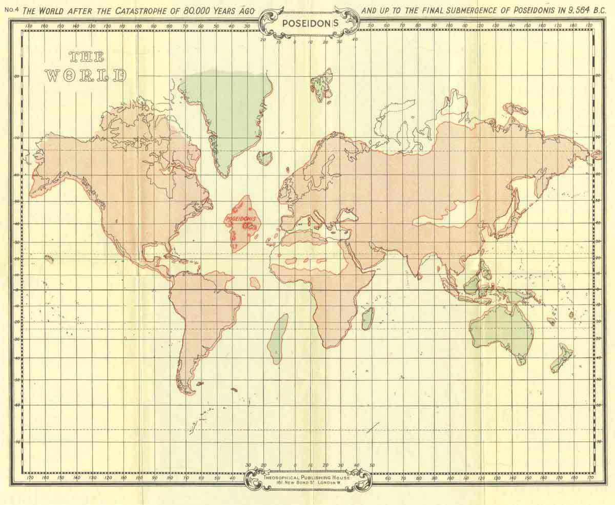
Theosophical map of Atlantis : Poseidonis

Myth from misinterpretation

The only way to make a mystery out of Atlantis (and to assume that it was once a real place) is to ignore its obvious origins as a moral fable and to change the details of Plato's story, claiming that he took license with the truth, either out of error or intent to deceive.
With the addition, omission, or misinterpretation of various details in Plato's work, nearly any proposed location can be made to "fit" his description.

Yet as writer L. Sprague de Camp noted in his book Lost Continents, "You cannot change all the details of Plato's story and still claim to have Plato's story.
That is like saying the legendary King Arthur is 'really' Cleopatra; all you have to do is to change Cleopatra's sex, nationality, period, temperament, moral character, and other details, and the resemblance becomes obvious."

The Atlantis legend has been kept alive, fueled by the public's imagination and fascination with the idea of a hidden, long-lost utopia.
Yet the "lost city of Atlantis" was never lost; it is where it always was: in Plato's books.

Monday, September 17, 2012

Canada CHS update in the Marine GeoGarage


31 charts have been updated (August 30, 2012) :
    • 1230    PLANS PENINSULE DE LA GASPESIE       
    • 1313    BATISCAN TO LAC SAINT-PIERRE       
    • 1316    PORT DE QUEBEC       
    • 1351A    BASSIN DE CHAMBLY TO ILE SAINTE-THERESE       
    • 1351B    ILE SAINTE-THERESE TO POINTE LA MEULE       
    • 1351C    POINTE LA MEULE TO POINTE NAYLOR       
    • 1351D    POINTE NAYLOR TO LAKE CHAMPLAIN       
    • 1429    CANAL DE LA RIVE SUD       
    • 1430    LAC SAINT-LOUIS       
    • 1510A    LAC DES DEUX MONTAGNES       
    • 1510B    LAC DES DEUX MONTAGNES       
    • 3602    APPROACHES TO JUAN DE FUCA STRAIT       
    • 3671    BERKLEY SOUND       
    • 4002    GULF OF ST. LAWRENCE       
    • 4010    BAY OF FUNDY INNER PORTION
    • 4024    CHALEUR BAY ATO ILES DE    LA MADELEINE
    • 4026    HAVRE-SAINT-PIERRE ND CAP DES ROSIERS TO POINTE DES MONTS
    • 4114    CAMPOBELLO ISLAND       
    • 4115    PASSAMAQUODDY BAY AND ST CROIX RIVER       
    • 4140    AVON RIVER AND APPROACHES   
    • 4211    CAPE LAHAVE TO LIVERPOOL BAY       
    • 4240    LIVERPOOL HARBOUR TO LOCKEPORT HARBOUR       
    • 4279    BRAS D'OR LAKE       
    • 4379    LIVERPOOL HARBOUR       
    • 4459    SUMMERSIDE HARBOUR AND APPROACHES
    • 4471    BAIE AU SAUMON TO BAIE DES HOMARDS       
    • 4486    CHALEUR BAY       
    • 4498    PUGWASH HARBOUR AND APPROACHES
    • 4905    CAPE TORMENTINE TO WEST POINT       
    • 4909    BUCTOUCHE HARBOUR       
    • 4913    CARAQUET HARBOUR  BAIE DE SHIPPEGAN  AND MISCOU HARBOUR
    • 4921    PLANS- CHALEUR BAY - NORTH SHORE
    • 4950    ILES DE LA MADELEINE       
    • 4954    CHENAL DU HAVRE DE LA GRANDE ENTRE       
    • 4955    HAVRE-AUX-MAISONS        

    So 688 charts (1659 including sub-charts) are available in the Canada CHS layer. (see coverage)

    Note : don't forget to visit 'Notices to Mariners' published monthly and available from the Canadian Coast Guard both online or through a free hardcopy subscription service.
    This essential publication provides the latest information on changes to the aids to navigation system, as well as updates from CHS regarding CHS charts and publications.
    See also written Notices to Shipping and Navarea warnings : NOTSHIP

    Sea cameras scan the waves for smugglers

    Tracking multiple targets from a camera installed on a buoy.
    The buoy is deployed near a channel.

    From NewScientist

    On 6 September, at least 61 migrants seeking refuge in Europe drowned in the Aegean Sea off the coast of Turkey when their boat hit rocks.


    A day later another migrant boat sank off Lampedusa, Italy - and dozens are feared dead.

    A CCTV system for the ocean could help coastguards detect these overcrowded boats sooner, and perhaps save lives.

    Buoys fitted with cameras have long been thought to be the best means to watch the seas.
    They would photograph vessels as they passed along the horizon, sending images to coastguards via satellite.
    Until now, though, this idea has been blocked by the inability of buoy-mounted cameras to capture clear, stable pictures in the ocean's swell.

    Camera that is attached to the untethered buoy will provide images of several possible categories of horizon images. 
    (a)–(d) Images with horizon clearly discernable. 
    (e) Camera points to the sky and sky is the only scenery visible in the image. 
    (f) Image of water surface only. 
    (g) Objects such as ships when they take a big fraction of the field of view may seriously affect horizon detection. 
    (h) Blur that comes from water splashes is another factor affecting horizon detection.


    Chad Lembke and colleagues at the University of South Florida in St Petersburg have designed an algorithm that enables a camera to detect the true horizon - rather than the edge of a nearby wave - even as it is tossed about in the open ocean.
    The algorithm identifies candidate edges that might be the horizon, and homes in on the correct one using the colour change between sea and sky.

     Consecutive frames of a video sequence exhibit high magnitude non-linear intra-frame motion in (a)–(c) which is the result of rapid camera motion.
    (d) shows registration of (a)–(c) in one coordinate system.
    (e) shows the values of one-dimensional normalized cross-correlation scaled in the range [0..1] during registration of frames (a) and (b) along the horizon line.
    The peak corresponds to the optimal alignment along the horizon line.

    The camera then automatically takes a picture or video of any objects whose outline rises above the horizon.
    The software ignores everything else, which reduces the computational power needed and so also the running power.
    This makes it useful for long-term use at sea, says Lembke.
    The power would come from solar, wind or wave action, he says.

    Steps of the segmentation algorithm: 
    (a) original image; (b) color-gradient filter; (c) thresholding; (d) filtering; (e) output.

    In more than 500 tests, the prototype correctly detected and tracked vessels up to 300 metres away 88 per cent of the time (Ocean Engineering, doi.org/h9g).
    By refining the algorithm's parameters, Lembke's team hopes to reach 98 per cent.
    And a better camera should be able to pick out ships up to a kilometre away, Lembke says.
    As well as detecting boats carrying migrants, the system could issue wireless alerts warning of the possible presence of pirates or drug smugglers.

    The idea has promise, says John Wills, technical director of the Institute of Marine Engineering, Science and Technology in London.
    "This proposal might help support the vital role of identification of potentially hostile craft at sea, as long as some simple practical issues, such as keeping the lens clean of saltwater spray, do not inhibit its operation."

    Sunday, September 16, 2012

    Alamar


    Before their inevitable farewell, Jorge a young man of Mayan roots and Natan, his half Italian son, embark on an epic journey into the open sea.

     A young boy and his father learn about living in harmony with nature in this languid drama from filmmaker Pedro Gonzalez-Rubio.


    A man from Mexico (Jorge Machado) travels to Italy and falls in love with a beautiful local woman (Roberta Palombini).
    Their feelings for one another are strong, but they prove to be short lived, and when they decide to beak up after the birth of their son Natan, he returns to Mexico while she stays in Italy and takes primary custody of the child.
    However, the father strives to remain a presence in his son's life, and the boy visits his father at least once a year.
    As the five-year-old Natan travels to Mexico, his father has joined the family' fishing operation near the coral reefs of Banco Chinchorro.
    Living in an elevated cottage near the shore, Natan and his family devote their summer to an idyllic existence, spending their days catching the plentiful fish and observing the wildlife, and their nights sitting by the fire and admiring the stars.
    To the father, this simple life teaches an important lesson of existing in peace with the natural world, and Natan comes to see himself as being as much a part of this environment as the fish, the waterfowl and the seaweed.

    Links :