Jakarta is considering a $40 billion-plus project to build an outer sea wall and 17 artificial islands, which together would be shaped like a Garuda—the mythical bird that's Indonesia's national emblem.
Jakarta, Indonesia’s fast-growing capital of 10 million people, is embarking on one of history’s biggest seawall projects—to be shaped like a Garuda, a mythical bird-like creature.
Standing on the banks of Jakarta Bay, Victor Coenen sees flimsy houses with sheet metal roofs sitting on the city’s seawall.
A girl wearing flip flops and a pink bow walks along the wall, only a couple feet off the ground.
Coenen points to cranes trying to clear waterways that are clogged with plastic debris and water hyacinth while nearby, in the low-lying Pluit district, mopeds and bicycles ride through flooded streets.
“The city cannot keep up with the sinking,” says the Dutch physical geographer during a tour of the town, noting it’s dropping 3 inches (7.5 centimeters) each year on average and up to 10 inches in some areas—exponentially faster than Venice, the famous “City of Water.”
In fact, Jakarta could be the Titanic of the world’s metropoles, a place where children wade through waist-deep brackish water to get to school and nearly half its people live with frequent flooding.
Last Christmas, during high tide, water poured over the Pluit seawall.
In 15 years, 80 percent of the northern city will lie below sea level—up from 40 percent now.
In 50 years, current streets could be at least 10 feet below it.
So this former Dutch trading post is embarking on one of history’s biggest seawall projects.
In three phases over three decades, it aims to build an exterior wall off the coast that would be 25 miles (40 kilometers) long and 80 feet high, a third of which would sit above sea level.
That’s not all.
To help pay for the $40 billion-plus behemoth, developers could buy land on 17 new artificial islands and build luxury homes, shopping malls and Grade-A offices.
Together, the wall and islands would be shaped like a Garuda, the mythical bird-like creature of Hinduism that’s the national emblem of Indonesia.
“We’re trying to build a seawall city. That’s completely new,” says Coenen, who’s managing the project in Jakarta for the engineering and consulting firm of Witteveen+Bos, part of a Dutch consortium that prepared the master plan.
Flimsy homes are built on the existing sea wall in the low-lying Pluit area of Jakarta
as shown on February 2, 2015.
The Great Garuda, as it’s known, has only just begun.
Last year, the city began work on the first phase, which entails raising the existing sea wall an average of seven feet over the next two years.
Officials will then decide whether to give the go-ahead for the final two phases, but it’s unclear what they’ll do.
Also unclear: Would this project, which has plenty of skeptics, even work?
The Lure of Seawalls
Since ancient times, seawalls have been built to keep water at bay.
Their popularity is on the rise as the world’s seas, almost a foot higher than a century ago, are projected to climb more because of climate change.
Countries across the globe will build walls to protect themselves, because the price of these projects is cheaper than the cost of flooding, according to a 2014 study.
The U. S. government spent more than $14 billion on gates and walls to protect New Orleans after Hurricane Katrina devastated the Gulf Coast in 2005.
The Dutch have built huge dikes, and in 2010, South Korea finished the world’s longest man-made one: the 22-mile Saemangeum Seawall.
Yet seawalls have failed to prevent catastrophe.
Japan’s 2011 tsunami brought waves that overwhelmed its seawalls, leading to a meltdown at its coastal Fukushima Daiichi nuclear power plant.
Now, it’s proposing a new 250-mile-long, four-story-high sea barrier.
Jakarta’s plan is controversial.
A government study said it could erode islands, damage natural habitats such as coral reefs, and force the relocation of thousands of coastal people including fishermen.
Skeptics say it could exacerbate corruption, spur more development, and avoid fixing the root of the problem: massive groundwater extraction.
“It’s treating the symptoms, not the cause,” says Christophe Girot, a professor at the Swiss Federal Institute of Technology in Zurich who did a case study on Jakarta.
He says most of the sinking is due to households, developers, and industry illegally extracting groundwater to obtain free fresh water.
“It’s the Far West. It has a frontier feeling, a free-for-all,” Girot says, noting the city grew rapidly without treating enough wastewater to provide piped-in drinking water for all residents.
Also, he says it’s failed to stop the dumping of trash into the waterways, an estimated 500 tons daily, that make the water costlier to clean.
“You just throw your stuff into the river,” which can be 20 feet deep in plastic, he says.
“It’s a self-perpetuating problem,” he says, and since the water is a toxic sludge containing lead and mercury, “it’s also a public health problem.”
Cranes remove water hyacinth from the Pluit flood reservoir on Feburary 2, 2105.The fast-growing hyacinth, along with trash, clogs waterways and drainage pumps.
Others agree.
A recent editorial in the Jakarta Post, Indonesia’s largest-circulation English language daily newspaper, called for a “high-capacity” wastewater treatment plant.
“Although it took them decades, Tokyo and Bangkok have managed to stop groundwater extraction and Jakarta definitely can do it, too. It must,” the paper says.
“And when Jakarta has done it, who needs to close Jakarta Bay with a giant seawall?”
Time’s Running Out
“You have to do it all,” says Gijs van den Boomen of KuiperCompagnons, a Dutch firm that designed Jakarta’s urban plan.
If people wait for the city to take all the steps needed to stop groundwater extraction, he says it will be too late.
“It’s staggering, almost unimaginable,” he says about the scope of the sinking. He says the project includes cleaning the 13 rivers that will pour into a newly created reservoir—located between the outer and inner seawalls—and treating the water so “we don’t create a lagoon of death.”
Woman picks through trash that surrounds a slum in northern Jakarta on February 1, 2015.
Coenen says there are hydrological deadlines.
Parts of the current seawall, raised in 2008 after a massive 2007 flood covered nearly half the city in as much as 13 feet of muddy water, are already submerged at high tide.
He says upgrading it will protect Jakarta only until 2025, at which time the outer wall will be needed.
“There are no small or easy solutions,” he says, noting it won’t be easy for the city to either halt subsidence or build the Great Garuda.
He says it’s approved funds to heighten the one third of the current wall that sits on public land; the other two-thirds tend to be in better shape, because landowners protect their property.
The Dutchmen working on the project acknowledge it could cause some environmental harm, but they don’t see a better alternative.
They expect changes to their master plan as the city decides whether to proceed. Since the outer wall will take six to eight years to build, Coenen says, Jakarta needs to get started within a few years.
“This is a city of maybe,” he says, adding: “It’s difficult to predict what will happen.”
Ron Howard's "In the Heart of the Sea" is a curious beast.
The ambitions are as big as a whale; the results are an earnest wreck.
It could possibly work if you think of the movie as a metaphor for the story it's trying to tell, but that's a little too meta for something that should be fairly straightforward.
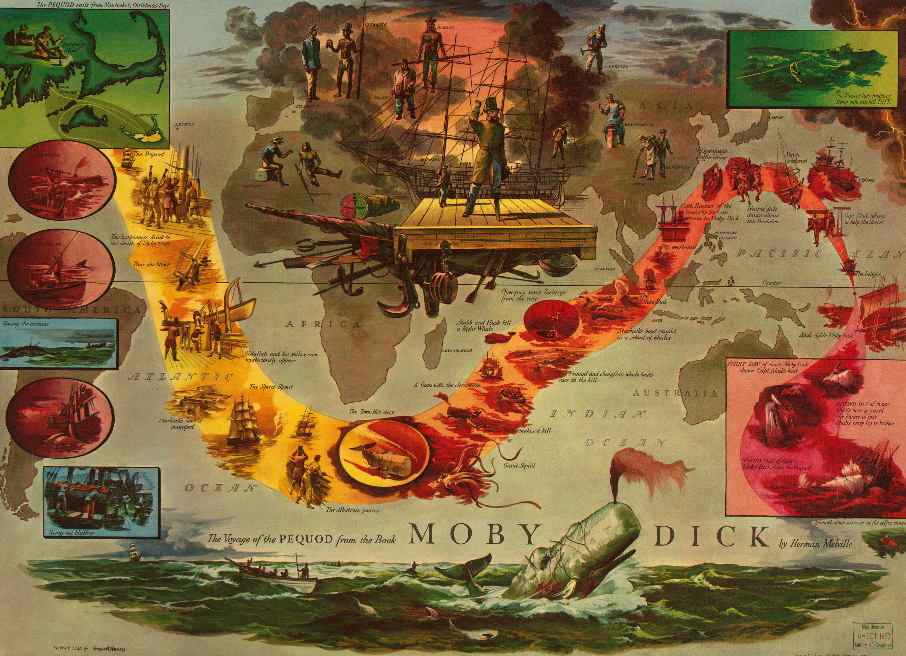
Voyage of the Pequod (illustrated by Everett Henry).
It's ostensibly about the real expedition that inspired Herman Melville's "Moby-Dick" that Nathaniel Philbrick wrote about in his nonfiction book.
But despite a promising start, something is lost in the spectacle and the framing device, which ultimately undermines its own story.
Howard uses Melville as a character (played by Ben Whishaw) and his curiosity about the mysterious circumstances of how the whaleship Essex sank as the audience's entry into the story.
He's looking for big answers about the unknown.
So, he finds Tom Nickerson (Brendan Gleeson), the ship's only remaining survivor, who's drinking his life away.
At his wife's pleading, and Melville's promise of generous payment for one night's conversation, Tom starts to spill about the events of 30 years ago, when he was 14 (played by Tom Holland).
It's best not to do the math.
This is the story of two men, he says: A captain, George Pollard (Benjamin Walker), and his first mate, Owen Chase (Chris Hemsworth). Pollard is the son of the expedition's proprietor.
He's wealthy, arrogant, entitled and inexperienced.
What works: It's certainly ambitious, and it features striking, memorable scenes of how a whaling ship goes about capturing its prey. What doesn't: The pieces never mesh together into a cohesive whole, with little insight to the characters and even less emotion.
Chase is the real seaman — a working-class Adonis with a classist chip on his broad shoulders.
He's also arrogant, but has the skills to back it up.
Chase flexes his hero muscles early, bounding up a ladder to cut free a tangled sail, and the captain responds with ill-advised bravado in leading the men full-speed into a squall.
But the "who leads" question is abandoned quickly and without much resolution once the whaling starts.
Perhaps the most striking scenes are those that deal with the process of catching a whale, from spearing to the gory disemboweling.
But whales are scarce on the ship's normal route and they must sail on to get enough oil for their bosses.
It's thousands of miles off the coast of South America where they encounter the big one, which locks on the Essex with a Terminator's resolve.
Hemsworth is best when he's by himself — either barking orders or doing something physical.
Of all the actors he shares scenes with, it's Cillian Murphy as his second mate who brings out something resembling emotion.
But we never really care about the lead, so there's little hope that we'll be interested in the rest of the men once it becomes solely about survival.
Indeed, most of the second half is spent drifting with them on lifeboats.
In these interminable minutes, we don't get anything resembling an understanding of how they survived (or didn't) either mentally or physically.
Future Tom Nickerson isn't much help either, and Melville is already too focused on his own literary ambitions to actually ask the big questions he told us he was seeking.
"In the Heart of the Sea" tries to be about so many things — ambition, capitalism, greed and survival. In the end, it feels most interested in how Herman Melville got his classic.
The pieces are there, but apparently it's up to "Moby-Dick" to assemble them, not Ron Howard.
Seventy percent of Earth’s surface is ocean, and without it, the other 30 percent would barely be inhabitable.
The ocean absorbs and distributes heat around the globe, and it acts as a planet-sized CO2 scrubber, saving us all from a runaway greenhouse effect like the one that turned Venus into a hell-world.
But the ocean, like the rest of Earth’s climate system, is changing—and not for the better.
Taking the Heat
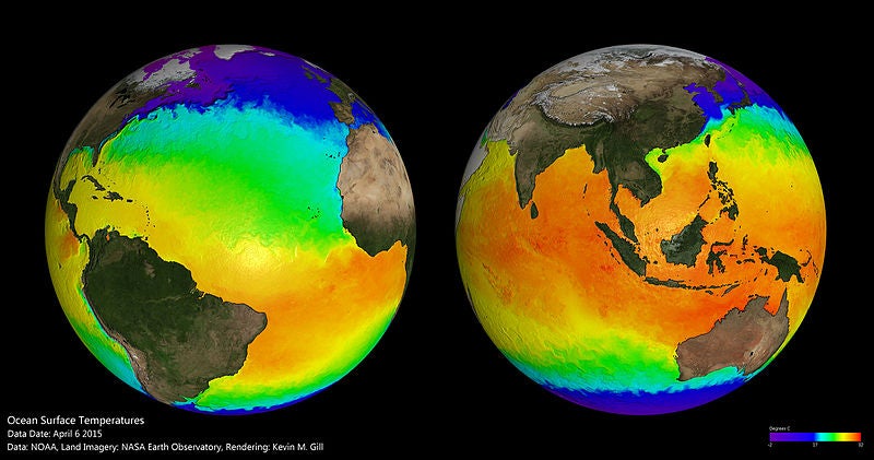
Ocean surface temperatures on April 6, 2015. Image: NOAA.
First and foremost, the oceans absorb heat.
Without them, scientists estimate that the atmosphere would already be 20⁰C warmer than it is now.
Of the extra heat trapped inside Earth’s atmosphere by the greenhouse effect, about 90 percent actually gets absorbed by the ocean.
“The oceans are saving us, just because they have very high heat capacity,” said researcher Anna Cabre of the Ocean and Climate Dynamics Group at the University of Pennsylvania.
It takes about one Joule of energy to warm a gram of air by 1° Celsius, but a gram of water needs about four Joules of energy to raise its temperature by 1°.
(You don’t usually measure water in grams, because it’s a liquid, but the unit is useful for the sake of comparison).
Earth’s oceans are vast and deep; on average, the water is 2.3 miles deep (it’s much shallower in some places, and in others it’s as deep as seven miles).
That’s roughly 352,670 trillion gallons of water, giving Earth an enormous heat sink.
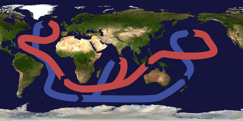
The oceans also help spread that absorbed heat around the planet, which helps moderate Earth’s climate.
The tropics get about four times more solar heating than the poles do, because the Sun’s radiation hits the equator at a much more direct angle there.
That’s why tropical waters tend to be warmer than, say, the North Atlantic off the coast of England. Those temperature differences create a pattern of circulation, where warm water from the tropics flows north to the Arctic or south to the Antarctic.
As cooler water sinks, it flows southward to the tropics again, and warm water flows north to take its place.
Without the ocean’s system of circulation, solar radiation that fell on the tropics would stay in the tropics, making equatorial regions significantly warmer and leaving higher latitudes to shiver in the cold.
In the Atlantic, for example, warm water from the tropics flows up toward the Arctic in a current known as the Gulf Stream. Four billion cubic feet of water every second flows past the east coast of the U.S. and Canada, moving about four miles per hour before turning toward Europe.
“It’s incredible the amount of heat that the ocean transports through the Atlantic,” said Cabre.
That heat keeps Northern Europe warmer than it would be otherwise at such a high latitude.
Storing Carbon
Heat isn’t the only thing the ocean absorbs; it also acts as a giant CO2 scrubber for our planet.
The ocean has absorbed between a quarter and a third of all the carbon we’ve pumped into the atmosphere so far.
Since 2002, the ocean has pulled 2.5 billion tons of CO2 out of the atmosphere and banished it to the deep.
Sinking all that carbon has helped mitigate the effects of global warming.
Coloring the sea around the Alaska's Pribilof islands
The system works because carbon dioxide dissolves easily in water.
Carbon dioxide molecules bind with water molecules to create carbonic acid (H2CO3), which mostly breaks down into positively-charged hydrogen ions (H) and negatively charged hydrogen carbonate ions (HCO3).
Mostly, that process happens in shallower water, but as water cools and sinks near the poles, it pulls CO2 down into the depths.
Oceanographers call that the solubility pump, and it accounts for most of the ocean’s ability to sink carbon.
But the ocean is teeming with life, and its smallest organisms also play an important role in pulling out CO2 of Earth’s atmosphere.
Scientists call this the biological pump.
Microscopic plants called phytoplankton gobble up CO2 to use in photosynthesis, and when they die, their remains carry some of that CO2 with them to the ocean floor.
Most of that gets released back into the water as the phytoplankton decay, but by then it’s already in the deep ocean.
Phytoplankton.
Image: NOAA.
It takes a long time for water to rise again after it sinks down into the depths of the Arctic; it will be another 500 years or more before the carbon that’s being absorbed by the ocean today next sees the light of day at the surface.
But it will eventually rise, when the ocean conveyor belt carries it to the warm tropics.
Warm water can hold less dissolved gas than cold water, so as water warms and rises to the surface near the Equator, it releases its stored carbon.
Normally, the ocean absorbs about as much CO2 as it releases, so the system stays in balance.
That balance is skewed now, thanks to all the excess CO2 we’ve pumped
into the air since the Industrial Revolution in the 19th century.
Now,
the oceans are absorbing more CO2 than they release, and the imbalance
is taking a gradual toll on the whole system.
But it’s not because the oceans are saturated with CO2—they’re
nowhere close, according to Cabre. “Are we reaching a point where the
ocean cannot absorb any more carbon? Not yet,” she said.
She says the
ocean could probably store another few hundred years’ worth of CO2, but
it would come with a price.
The process of dissolving CO2 into water
makes the water more acidic.
That process is already causing some marine
animals’ shells to dissolve, and if it keeps getting worse, it will
wreak havoc on most ocean organisms.
“If you only care about storing carbon, there’s
still a lot of space,” said Cabre, “but then you increase acidity, which
is bad for a lot of things.”
Instead, the problem is heat.
Ocean warming trend from 1955 to 2008.
Image: NOAA.
Water warms very slowly, but the ocean is inexorably heating up.
The deep ocean is warming slowest, at an average of 0.002° Celsius per year in the waters below 1600 feet (about 500 meters) over the last few decades.
Above that, the upper 1600 feet of the ocean have warmed an average of 0.005° Celsius per year.
The waters within about 250 feet of the surface are heating up by 0.01°C per year.
Warmer water can’t hold as much CO2 as cooler water.
Ocean warming also slows the circulation that sinks carbon and mixes carbon from the surface layers with water from the rest of the ocean.
In fact, ocean circulation in the Atlantic has been slowly weakening since the 1970s, and it’s now about 15 to 20 percent weaker than it was earlier in the 20th Century.
Researchers say that may be at least partly thanks to the melting of the Greenland Ice Sheet—researchers such as Stefan Rahmstorf of the Potsdam Institute for Climate Impact Research in Germany, who along with his colleagues, published findings on weakening Atlantic circulation in Nature earlier this year.
Warmer water helps melt the ice sheet, which in turn releases fresh water and lowers the salinity of the North Atlantic.
Fresher water is less dense than saltier water, so the sinking of salty water that drives circulation in the Atlantic starts to slow down.
That’s why the area of the North Atlantic just south of Greenland has been colder in recent years—less heat is flowing northward with the Gulf Stream and the North Atlantic Drift.
It’s also why, despite last winter being the warmest winter on record so far, the North Atlantic and the eastern seaboard of the U.S. experienced record cold.
Because the Sun’s heating of the Earth isn’t an even process, neither is global warming; instead, it’s a process full of extreme variations which are too easily masked by global average figures.
Over the next century, those extremes could deepen if the oceans continue absorbing more and more excess heat from our atmosphere.
As the global average temperature increases, the tropics will get hotter, but parts of Europe will get much colder.
The ocean will sink less CO2, so the atmosphere will warm more quickly; the ocean will absorb much of that excess heat, and circulation will slow a little more.
Recovering Balance
Image: Leon Brooks via Wikimedia Commons.
The good news is that the feedback effect works both ways.
If we manage to reduce the amount of CO2 being added to the atmosphere, the system will recover its balance again; that’s the beauty of physics.
If we pump less CO2 into the atmosphere, the greenhouse effect will slow down, and the atmosphere will stop heating up.
Earth’s vast carbon-scrubbing oceans will have a chance to catch up, and as they pull CO2 from the atmosphere, things may start to cool down again.
Circulation will strengthen again, which will make the ocean more effective at absorbing both heat and CO2.
We just need to stop overloading the system with CO2, and it will keep working smoothly and making our planet a livable place.
There are a wide
variety of challenges and studies going on aboard FALKOR.
This led to
further investigation of the site with the Autonomous Underwater Vehicle
(AUV) Sentry.
Animation showing the Sentry AUV collecting multibeam sonar data
during a
dive and then taking photographs of the seafloor.
Credit: Woods Hole
Oceanographic Institution.
The result was a beautiful high-resolution bathymetry map
and an even more-detailed photographic
survey of the seafloor in the area of interest.
Preliminary AUV Sentry multibeam data in the area of low-temperature
venting
discovered during CTD tow 6.
Sentry seafloor bathymetry data
resolution is 1 meter.
The white box shows the area of the Sentry photo
survey that captured the new lava flows.
To our surprise, the
photo survey discovered a very young lava flow in the area where the CTD tow-yo indicated low-temperature venting.
This led us to question: when was that eruption, and how big was it?
Maps showing the 2 ship multibeam bathymetry surveys in the area of the
newly-discovered lava flows.
The data on the left were collected in
2013, the data on the right in 2015.
The black polygons are the new lava
flows. Numbers on the 2015 map specify the maximum thickness of each
lava flow in meters.
The white box shows the area of the Sentry
bathymetry survey.
Doing the Math
This is where mapping we have done with R/V Falkor’s multibeam
sonar came into play.
Sonar systems send sound pulses from the ship to
the seafloor (called “pings”).
Present-day sonar systems can provide up
to 432 individual depth readings (“soundings” or “beams”) across each
ping - this is where the term “multibeam” gets its name.
The amount of
time it takes each sound pulse to return to the ship indicates the depth
beneath the ship: the longer it takes the sound to return, the deeper
the water.
Those depth soundings are pulled together to create a grid of
the seafloor.
Ship-acquired seafloor depth information is scarce and
expensive to acquire, so whenever the opportunity presents itself
scientists will collect sonar data - even if they have no plans to use
it for their individual research.
One aspect of my job is to compile all
the ship sonar data collected in the areas where we work and pull it
together into a database.
Because of this, we have with us the multibeam
sonar data collected on a previous cruise to this area in 2013 (by
Patrick Shore and Doug Wiens on R/V Melville), and we’ve
resurveyed the same area during this expedition.
By performing a little
bit of math, we can calculate the difference in the seafloor depths
between then and now.
The earlier grid (2013) is subtracted from the new
data (2015) and depth differences in those grids show changes in the
seafloor between now and then.
The Results
Surface differencing is a quick way to show us where the new lava
erupted on the seafloor, and we can also calculate the volume of new
lava flows.
The results reveal that the new lava flows extend over 7
kilometers from north of south, and that greater than 60,000,000 cubic
meters of lava was deposited on the seafloor.
The northernmost lava flow
was the largest, with a volume of over 20,000,000 cubic meters, piling
up pillow lavas over 125 meters (400 feet) thick.
Now that’s the kind of
math that I find incredibly exciting!
Gold and jewels on board Spanish ship the San José that sank 300 years ago off Colombia could be worth billions
The wreck of a Spanish galleon laden with treasure has been found 300 years after it was sunk by the British, sparking speculation that it contains the most valuable haul ever found on the seabed.
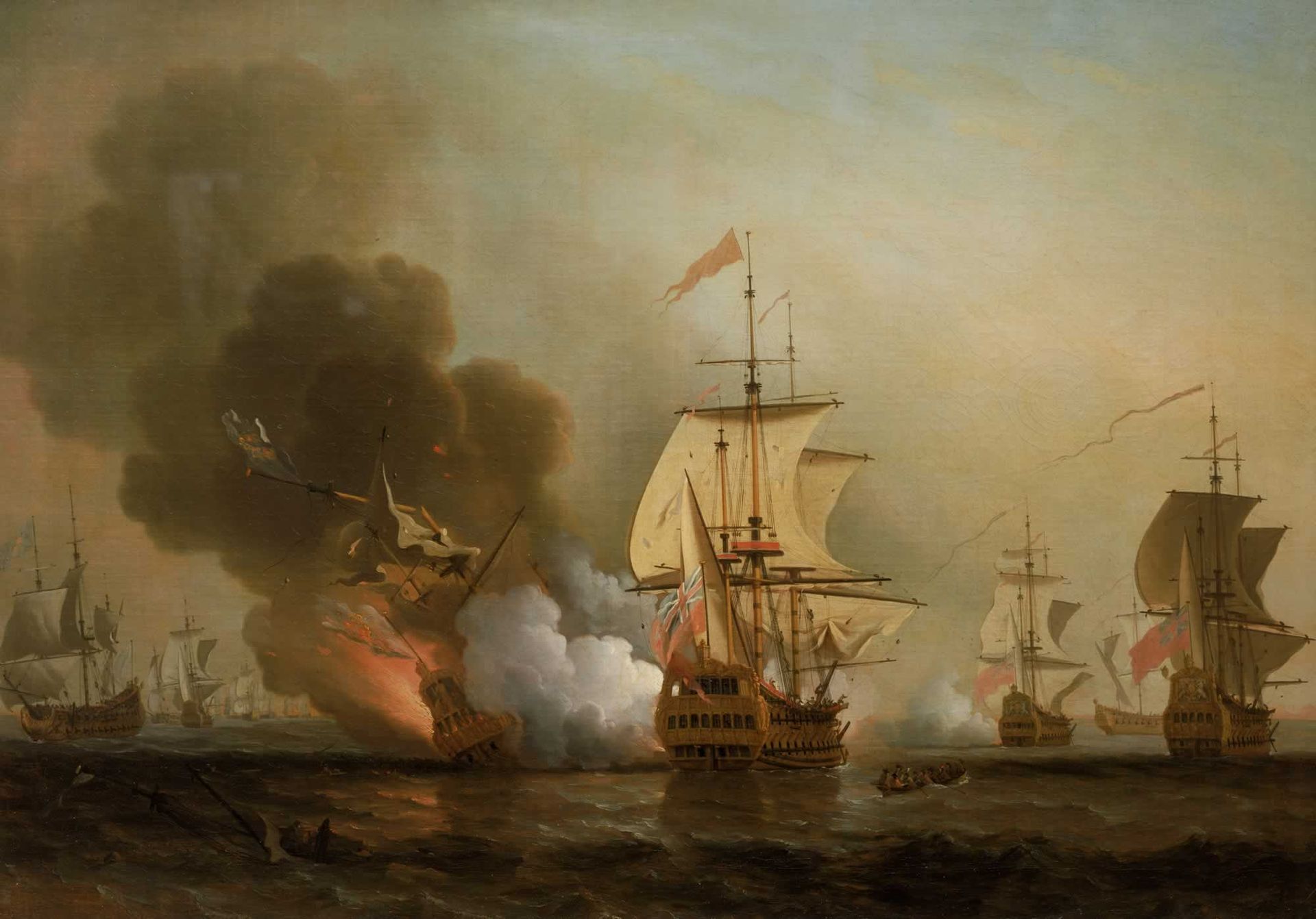
Oil painting by Samuel Scott depicting the action off Cartagena, 28 May 1708
The Colombian president, Juan Manuel Santos, announced the find and said a museum would be built to display the artefacts, which are thought to include gold, coins, silver, emeralds and other gems and jewellery and the personal wealth of the viceroy of Peru.
The ship, the San Jose, has been described as the holy grail of shipwrecks, carrying one of the richest treasure cargos ever to have been lost at sea.
The treasure was collected in the South American colonies to be shipped to Spain to help fund King Philip V’s war of succession against the British.
Santos said the treasure was now worth at least £662m, although other estimates have said it could run into billions.
courtesy of El Pais
The ship was sunk in 1708 in the Caribbean Sea close to the walled port city of Cartagena during heavy fighting with the British.
A team of international experts, the Colombian navy and the country’s archaeology institute discovered the wreck last week near the island of Baru.
Location of the shipwreck with the GeoGarage platform (CIOH charts)
Dr. Carla Rahn Phillips' estimation (inside the polygon) of the location of the Galeon San Jose - off Cartagena, Colombia (OSRI) In a follow-up statement, the presidency said the shipwreck was discovered at a site “never mentioned in previous studies.” The
fate of the treasure has been the subject of a long-running legal
battle with U.S.-based Sea Search Armada, which claims its predecessor
found the wreckage in 1981. SSA has been claiming billions of dollars for breach of contract from the Colombian government, but in 2011 an American court ruled that the galleon was the property of the Colombian state.
zoom on the area with the GeoGarage platform (CIOH nautical charts) English Commodore Charles Wager tracked down the treasure-laden ship
25km (16 miles) off Cartagena and it sank in 200-300m of water. In the fighting the vessel was reported to have exploded, with most of its crew killed.
The president tweeted: “Great news! We have found the San Jose galleon.”
Later he went on television from Cartagena’s naval base and said: “Without a doubt, we have found, 307 years after it sank, the San Jose galleon. We will build a great museum here in Cartagena.”
He said the find “constitutes one of the greatest – if not the biggest, as some say – findings and identification of underwater heritage in the history of humanity.”
The remains of the Spanish galleon San Jose,
which sunk off the Caribbean coast of Cartagena de Indias, Colombia
Ownership of the ship’s treasure has been the subject of a long-running legal dispute.
In 1981 an American-based salvage company, Sea Search Armada, said it had located the area where the ship sank.
Sidescan sonar view
The company and the government agreed to split any proceeds, but the government later said all treasure would belong to Colombia, a view that was backed by a US court in 2011.
The supreme court ruled that Colombia held the rights to items deemed to be “national cultural patrimony”.
Anything else would be halved between the salvage company and Colombia.
Sonar images have revealed bronze cannon made specifically for the ship, arms, ceramics and other artefacts, said the president.
The 150ft long ship with a beam of 45ft was armed with 64 guns.
Some 600 people went down with the vessel after it exploded when hit by fire from a British warship.
The wreck falls within the UN’s definition of an underwater cultural heritage site.
Archaeological excavation and scientific tests will continue to ensure it can be properly preserved, said the president.
Routes of the Spanish galeons
The San Jose was part of a Spanish fleet that sailed to the Americas to load up with gold, silver, emeralds and other precious stones and metals.
The British sought to capture them as a way to cut off Spain’s war finances.
Commodore Charles Wager, in command of four British ships including HMS Expedition, attacked the fleet off the island of Baru.
His plan had been to attack the largest ship, the San Jose, and take control of the crew and cargo.
However, as it was about to be captured it blew up and sank.
Wager described the close quarters broadsides, and said the San Jose exploded with such intensity that he could feel the heat from his own ship.
“I believe the ship’s side blew out, for she caused a sea that came in our ports,” he wrote.
“She immediately sank with all her riches.”
It is estimated that the San Jose is one of more than 1,000 galleons and merchant ships that sank along Colombia’s coral reefs over more than three centuries of colonial rule.
Follow seven international teams as they race 38,739 nautical miles around the world in the 12th edition of the Volvo Ocean Race.
Along with being the foremost offshore sailing competition, the race reminds us about the vastness of our Oceans and what it means to be a modern day explorer.
 From La Pointe de l'Armorique to Brest


