Friday, April 14, 2023

Analysis: Western curbs on Russian oil products redraw global shipping map

 
Oil is pumped into an oil tanker at the Ust-Luga oil products terminal in the settlement of Ust-luga, April 9, 2014. 
REUTERS/Alexander Demianchuk/File Photo

From Reuters by Mohi Narayan and Jonathan Saul
 
Global fuel suppliers are turning to longer and costlier routes that produce more carbon emissions to move their diesel and other products as Western restrictions on Russian cargoes have reshuffled global energy shipping patterns.

As a result of the European Union ban on Russian fuel that started on Feb.
5, tankers carrying clean oil products such as gasoline, diesel, jet fuel and naphtha are travelling between 16 and 18 days to bring Russian supplies to Brazil or U.S. cargoes to Europe, according to two shipping sources.

That is up from the four to six days a ship used to travel from Russia to Europe, said the two sources, a broker at a major shipbroking firm and a charterer involved in the Russian trade of naphtha, which is used to make plastics and petrochemicals.

The ban comes on top of a halt late last year on Russian crude sales into the bloc as well as Western price caps.

Since the start of the ban, the Clean Tanker Index published by the Baltic Exchange, which measures average freight rates for shipping fuels like gasoline and diesel on some of the most common global routes, has more than doubled.

The redrawing of the shipping map underscores the knock-on effects of Western efforts to punish Russia over its invasion of Ukraine last year, adding to fuel supply insecurity and pushing up prices even as policymakers worry about inflation and the risk of a global economic downturn.

"Not only are voyages much longer, but vessel behaviour has also changed, keeping vessels from operating in other CPP (clean petroleum product) markets," Dylan Simpson, freight analyst at oil analytics firm Vortexa, wrote in a March 31 note.

Russian cargoes of fuel are heading to far-flung buyers in Brazil, Turkey, Nigeria, and Morocco as Moscow compensates for the lost European business, while Europe is importing more fuels such as diesel from Asia and the Middle East, according to shipping data from Refinitiv and Kpler.

Asian cargoes, in turn, are being displaced by Russian fuels in Africa and the eastern Mediterranean, and redirected to the blending hub of Singapore for temporary storage, two northeast Asian refinery sources said.

European importers whose naphtha cargoes travelled from Russian ports to Antwerp in four days before Russia's invasion of Ukraine now must wait 18 days for alternative supplies from the United States, the shipbroking source said.

Naphtha trade route before Russia-Ukraine crisis

The U.S. is also emerging as a top supplier of heavy naphtha to Europe amid the EU ban, while the Group of Seven Nations, EU and Australia have capped Russian naphtha prices at $45 a barrel and diesel and gasoline at $100 a barrel for trades that use Western ships and insurance.
Meanwhile, Brazil, traditionally a U.S. naphtha importer, is boosting purchases from Russia at more attractive prices.

However, the journey from Russia to Brazil can take 18 days or longer and, at up to $7 million per voyage, the costs are nearly double that of a U.S. shipment, the ship charterer involved in the Russian market said.

Brazil received around 240,000 tonnes of Russian diesel and gasoil in the first three weeks of March, accounting for a quarter of Brazilian imports, up from Russia's 12% share in February and less than 1% last year, said Benedict George, head of diesel pricing with energy and commodity data provider Argus.

"Until February, Europe had remained Russia's primary market for refined product exports; however, in the space of a month, a major pivot has been observed," tanker broker E A Gibson said in a recent report.

Naphtha trade routes after Russia-Ukraine crisis unfolded

LONGER DISTANCES, MORE POLLUTION

Measured in terms of cargo miles, which multiplies the cargo quantity in metric tonnes by the distance travelled in nautical miles, the amount of Russian oil product shipments to Brazil in March rose to 3.07 billion metric tonne-nautical miles (MT-NM) from 941 million MT-NM in November, according to data from valuation company VesselsValue.
Shipments from Russia to Nigeria rose to 1.88 billion MT-NM in March from zero in November, VesselsValue estimates showed.

Clean product cargoes to Saudi Arabia in March jumped to 1.75 billion MT-NM from 31 million MT-NM in November, while shipments to the United Arab Emirates were 4.43 billion MT-NM in March, up from 2.85 billion MT-NM in November, the data showed.

Also in March, Russian clean products shipped to Togo reached 973 million MT-NM, up from zero in November.
In volume terms, Brazilian imports of oil products from Russia were about 284,000 metric tonnes in February, up from 73,300 tonnes in September, VesselsValue data showed.
Conversely, Russian exports to the Netherlands dropped to 238,200 tonnes in February from 1.15 million tonnes in September.

Those longer distances are being done at higher costs for Russian products than for typical shipments from Europe.

According to market estimates, freight rates for the UK/European continent to West Africa are quoted at $55.77 per tonne for a product tanker with a standard 37,000-tonne load.
This compares with an indicative rate of $174.24 per tonne for shipments from Russia's Baltic ports to Nigeria, $103.84 for Morocco and around $150 to Egypt.

With ships travelling further, that is also likely translating into greater emissions from smokestacks.

Based on pre-pandemic data, a 10% increase in mileage for all tankers travelling to and from the European economic area would increase their emissions by around 1.5 million tonnes of carbon dioxide, equal to the emissions of around 750,000 cars per year in Europe, said Valentin Simon, data analyst with the Transport & Environment think tank in Brussels.

Links :

Thursday, April 13, 2023

China brandishes military options in exercises around Taiwan

 
A Chinese Navy ship near Dongju Island, Taiwan, on Monday.
Photographs by Lam Yik Fei

From NYTimes by Chris Buckley and Amy Chang Chien

The People’s Liberation Army’s ships, planes and troops held three days of drills in a spectacle designed to warn Taiwan against challenging Beijing.

China sent fighter jets, naval ships and an aircraft carrier near Taiwan on Monday in the final day of military exercises choreographed to raise pressure on the island while stopping short of an escalation that could set off a conflict.

China has said the three days of drills were retaliation against a visit by President Tsai Ing-wen of Taiwan to the United States last week and her meeting with Kevin McCarthy, the speaker of the House of Representatives.
Beijing claims Taiwan, a self-governed democracy, as its territory, and opposes such exchanges with the island’s leaders.

China has also seized the opportunity to use the drills to signal that Taiwan would be vulnerable if Beijing ever set out to claim the island by force, and that Washington could not be trusted to step into such a conflict.

The PLA Navy carrier Shandong under way (top) and launching a fighter (bottom)
(Japan Self Defense Forces)
 
During the drills, Chinese fighter jets practiced taking off from the aircraft carrier Shandong off the east coast of Taiwan, an island about 100 miles from China.
Other ships maneuvered in the seas around Taiwan.
Troops from the People’s Liberation Army were scheduled to hold live-fire practice off a small Chinese island that hugs the Chinese coast.

“Are the ‘security assurances’ provided by the United States reliable? The answer is, of course, negative,” said an editorial in the Chinese military’s main newspaper, the Liberation Army Daily, on Sunday.
“Its sinister designs to use Taiwan as a pawn, courting disaster for the two sides of the strait, are there for all to see.”

Experts have said the Chinese drills have been smaller and less menacing than similar exercises held in August to simulate a blockade after Nancy Pelosi, the former speaker of the House, visited Taiwan.

Even so, China’s display of force this time was full of intimidating messages and images warning of the potential consequences of defying Beijing’s demands for unification.

The Chinese military’s Eastern Theater Command, which oversees an area including Taiwan, said its forces were holding “simulated precision attacks,” and shared a short, crude cartoon of missiles raining around the island, and striking near or on its two biggest cities, Taipei and Kaohsiung.
The command also issued a video purporting to show a bomber taking part in the exercises.

More on ChinaTaiwan: China began three days of military exercises around Taiwan in what it called a “stern warning,” after the island’s president met with Kevin McCarthy, the speaker of the U.S.
House of Representatives
.
Trafficking Case: A Chinese court sentenced six people to prison for human trafficking and abuse of a woman who was found chained to a wall in a shack last year.
The case has provoked public outrage and reopened debate about the status of women in China.
Macron’s Visit: President Emmanuel Macron of France concluded a three-day visit to China, during which he had been expected to seek Beijing’s involvement in helping to end the war in Ukraine.
But a joint statement with China’s leader, Xi Jinping, said little about the conflict.

“I’ve arrived in skies north of Taiwan Island. The plane is operating normally and the missiles are in good shape,” a pilot says. The video ends with a voice saying: “Missile ready. Fire!”

By Monday morning, a total of 200 Chinese military aircraft had flown into Taiwan’s Air Defense Identification Zone — an informal buffer around the island — since the exercises began on Saturday, according to numbers issued by the Taiwanese defense ministry.
Such numbers are higher than the usual pattern of sorties.

Taiwanese military boats docked at a base in Su’ao, along the northeast coast of the island, last week.

 
Taiwan’s military has responded to the Chinese exercises with its own stream of images and announcements showing aircraft, soldiers and vessels at the ready to defend the island.

Live-fire exercises were scheduled to take place on Monday in the waters off Pingtan, an island in Fujian Province, opposite Taiwan, but details of what took place there were scant.
Later on Monday, the Chinese military declared that the exercises were completed and had honed its ability to “smash ‘Taiwanese independence’ separatism and external meddling in any form.”

“These exercises demonstrated a rapid response capability — they were announced in the morning, and the forces assembled in the afternoon to start military drills,” Song Zhongping, a commentator in Beijing who is a former military officer, said in messaged answers to questions.
“Each exercise will bring improvements, and that’s because each exercise is a preparation for battle,” he said.
“I, for one, don’t think that the deterrent level of these exercises has been any less than in August.”

Taiwan’s military has responded to the Chinese exercises with its own stream of images and announcements showing aircraft, soldiers and vessels ready to defend the island.

“What is quite worrisome is that, owing to the sharp increase in naval and air forces from both sides of the strait at close quarters near the median line and around Taiwan, the risks of accidents leading to an inadvertent exchange of fire have greatly increased,” said Chieh Chung, an adjunct assistant professor of strategic studies at Tamkang University in Taiwan.

 
Landing craft were parked Monday on Matsu Island, a Taiwanese island near the Chinese mainland.


A Taiwanese air force jet landing in Hsinchu, Taiwan, on Sunday.
By Monday morning, a total of Chinese 200 military aircraft had flown into Taiwan’s Air Defense Identification Zone since Saturday.


China said on Sunday that one of its ships was as close as 5 nautical miles from a Taiwanese naval ship.
Taiwan’s defense ministry said that the island’s forces were under orders to avoiding setting off incidents.
“As a responsible member of the international community, Taiwan will not engage in escalating clashes or provoking disputes,” the island’s foreign ministry said on Monday.

In China’s exercises last year, it fired at least 11 missiles into the seas off Taiwan.
Though the latest exercises have not involved missiles, experts will examine the drills for signs of how the People’s Liberation Army’s abilities have evolved.

One focus may be the Shandong, the Chinese aircraft carrier.
It sent dozens of sorties by fighter jets, according to Japanese military authorities.
The flights seemed to be the first time that Chinese J-15 jets, designed to operate from aircraft carriers, have been tracked entering Taiwan’s “air defense identification zone,” said Ben Lewis, an analyst who monitors such flights.

China deployed the aircraft carrier to reinforce its claim that it could “surround and encircle” Taiwan, said Ou Si-fu, a research fellow at the Institute for National Defense and Security Research in Taipei, which is affiliated with Taiwan’s defense ministry.
“That is to say that it can do it on our east coast, as well as our west coast,” Mr.
Ou said.

 
Preparing speedboats on Matsu Island, Taiwan, on Monday.
Taiwan’s defense ministry said on Sunday that the island’s forces were under orders to avoiding setting off incidents.


China launched the exercises on Saturday, shortly after President Emmanuel Macron of France finished a visit to China in which he sought to bolster cooperation and urged China’s leader, Mr.
Xi, to help end Russia’s war in Ukraine.
Mr.
Macron had told reporters that the Taiwan issue was not for him to judge and he did not detect any Chinese desire to “overreact.”

Many Taiwanese residents seemed largely unruffled by the exercises.
They have lived under Chinese threats for decades, and many see a real war as a distant danger.

“The drills in 2022 were totally different,” said Tsao Chih-ping, 26, a tour guide on Dongju Island, a Taiwanese island about 15 miles from Pingtan, China, who said she didn’t hear or see the past days’ exercises.
“I don’t feel the same tensions of last summer.”

Links :

Wednesday, April 12, 2023

Unmanned Surface Vessels become critical tool in mapping oceans and waterways

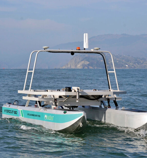
A HydroCat-180 from Seafloor Systems in San Francisco’s Horseshoe Bay.
Photo courtesy of Seafloor Systems.
 
From Inside Unmanned Systems by Sherrie Negrea

Unmanned surface vessels are becoming the tool of choice for mapping seafloors before new maritime infrastructure is put in place.

Off the coast of northern Europe, more than 120 wind farms have sprung up in the North Sea and Atlantic Ocean, either mounted on the seafloor or floating in deep water.
But before these massive wind turbines are installed, a critical step must take place—surveying the ocean bed.

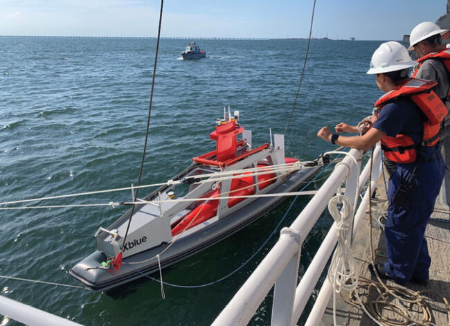
That is the task Unmanned Survey Solutions, based in Cornwall, England, sets out to accomplish in an area up to 15 nautical miles offshore with its Accession unmanned surface vessel (USV), which measures the water’s depth and identifies any obstructive objects embedded on the seafloor.

Energy companies and hydrographic surveyors are increasingly turning to USVs to map the seafloor before offshore wind farms are built because of several advantages they offer.
“They are less risky because there’s nobody on board so you don’t risk putting a person at sea,” said James Williams, CEO of Unmanned Survey Solutions.
“They are cheaper to operate primarily because they burn less fuel, and also they save huge amounts of carbon emissions.”

Over the past five years, government agencies and private companies around the world have been deploying USVs in place of crewed boats to map and survey oceans, rivers and ports before critical infrastructure—from wind turbines to tunnels—are constructed.
In response to this demand, USVs are evolving so that they can operate at sea for longer periods of time and can conduct more accurate measurements with advanced sensor technology.

“Uncrewed surface vessels are becoming much more popular because a lot of the sensors from a size, cost and weight perspective have really gotten smaller so that they can all be incorporated on these USVs,” said Vitad Pradith, technical director of construction technologies for Teledyne Marine, a manufacturer of USVs based in Thousand Oaks, Calif.
“That’s where this coalescing of all these technologies and uncrewed boats and sensors are all aligning to really solve a problem. And the problem here is just trying to collect data in typically inhospitable environments.”

 
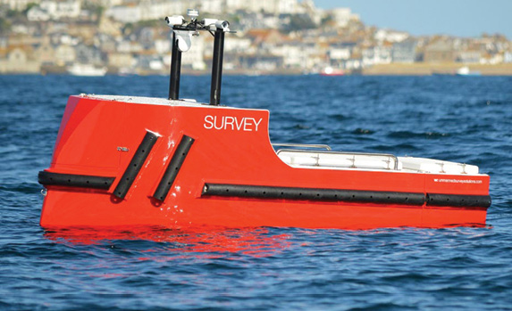
Unmanned Survey Solutions uses its Accession-class USVs to survey the ocean floor before wind farms are installed.
Photo courtesy of Unmanned Survey Solutions.


Mapping Lake Erie

Last September, the Thomas Jefferson, a ship operated by the National Oceanic and Atmospheric Administration (NOAA), arrived in the port in Cleveland to begin mapping Lake Erie for the first time in 35 years.
NOAA conducts the hydrographic survey of major U.S.waterways to determine the water’s depth and to identify obstructions and potential hazards to navigation.

Working alongside the ship was the DriX, a USV created by the French technology company iXblue that was also surveying the seabed.
In a partnership with the University of New Hampshire, NOAA’s Office of Coast Survey had conducted extensive testing of the DriX in 2019 and was taking the USV out on its first mission.

“The ultimate goal is to increase the efficiency of our manned, our crewed survey ships,” said Rob Downs, chief of NOAA’s Hydrographics and Systems Branch.
The Thomas Jefferson, he said, can survey for up to 24 hours at a time, while two smaller boats used in the process can map for up to 10 hours a day.

The DriX, which cost about $2 million, can operate 24 hours a day for five days at a time.
Its speed, which can reach 10 nautical knots, and endurance allows NOAA to map about 40% more of the area during the survey.

“Rather than having a crew out on a small boat that has to be brought back to sleep and be fed and have change watches, we can have one or two people monitoring the USV from the ship and the USV can be operating 24 hours at a time,” Downs said.
“So, we can make more efficient use of our ship and the personnel aboard our ships by using uncrewed systems.”

DriX prepares to launch from the DriX Deployment System.

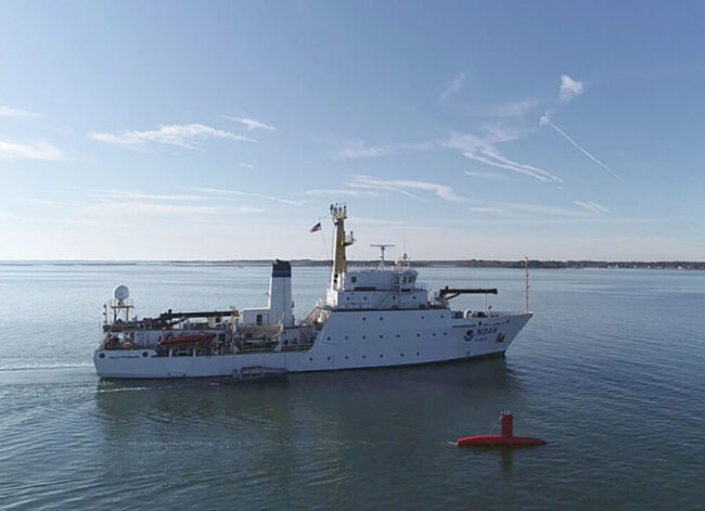
DriX and the NOAA Ship Thomas Jefferson in Norfolk, Virginia, which together mapped
the port of Cleveland, Ohio.
Photos courtesy of NOAA, credit to Ens.Taylor Krabiel and Patrick Faha.


Creating maps for the nation’s nautical charts is not the only way that NOAA will use the DriX.
This July, the USV will be headed to Alaska to conduct a fisheries survey, which will help NOAA use sonars to count the fish.
The results are used to determine the regulations that set the catch limits for commercial fishing boats.

“If we have a ship plus a USV team, and both of them have the sonars to count the fish, we can just really improve the productivity of that exercise,” said Capt.
William Mowitt, director of NOAA’s UXS Operations Center.
“For substantially the same inputs, we can count the fish more efficiently—we can count them faster.”

The increased efficiency of the surveys is critical to NOAA because of the impact climate change is having on the fish population, Mowitt said.
Because of global warming, fish are moving and changing their ranges, which means NOAA needs to expand many of its surveys.
“We don’t have more sea days so if we can create these ship-plus USV teams, we really increase the productivity of our fisheries survey mission,” Mowitt said.

NOAA is also using USVs to monitor ocean conditions and provide data to help forecasters better understand hurricanes.
Last year, NOAA launched seven surface drones created by Saildrone Inc. to track hurricanes in the Gulf of Mexico, the Atlantic Ocean and the Caribbean Sea.

In September, one of the Saildrones was operating inside Hurricane Fiona, a Category 4 storm that killed 31 people in the Caribbean and Canada.
One of the goals of the operation was to gather data that could help predict the rapid intensification of hurricanes, which would improve storm forecasting and better prepare communities in the path of a hurricane.

After nearly a decade of evaluating USVs, NOAA hopes it will integrate unmanned vessels throughout its operations.
“We’re getting to the part where we’re putting these into routine operations to support NOAA missions,” Mowitt said.
“We’re not evaluating, we’re not testing—we’re doing.
It’s exciting to see that transition from promise to evaluation to routine operations.”
 
Aiding waterfront construction

In any construction project near the water’s edge, USVs are becoming an indispensable tool in mapping the seafloor to eliminate potential hazards for new infrastructure.

In Virginia, the largest construction project in state history is relying on USVs to survey the seafloor in a harbor connecting Norfolk and Hampton, where a bridge will be moved, two new tunnels built, and a highway widened.

During the construction of the $3.8 billion project, two HydroCat-180 USVs made by Seafloor Systems Inc., based in Shingle Springs, California, were deployed to determine if there had been any changes in the seafloor as the new tunnel was constructed.

“They want to makes sure that bottom isn’t changing at all as they’re building this new structure and driving the piles,” said Cody Carlson, business development manager for machine control at Seafloor.
“They’re ensuring that all of this construction material is going in the right place and in the right quantities.”

The USVs produced by Seafloor all use a single beam or multi-beam sonar system that time stamps an acoustic ping and measures the time and angle of its return.
The USVs can also create 3D terrain models of the seafloor.

Using uncrewed surface vessels equipped with sonars has replaced the time-honored method of measuring depth—having someone on a barge drop a rod or a line with a weight into the water.
“The uncrewed surface vessel is a platform that carries sensors and technologies which allow end-users to gather information,” Pradith said.
“They do it in a way that is usually more efficient and safer than the way it used to be done.”

In Europe, a rapidly growing industry—offshore wind farms—has started to leverage USVs to survey the seafloor before new wind turbines are built at sea.

Before a wind farm is constructed, governments offer energy companies an area of the seabed that is available for the project.
USVs are then used to survey the area and determine whether the depth is correct and whether there is any unexploded ordnance from World War II, a common problem in the North Sea, said Williams, the founder of Unmanned Survey Solutions.

The preconstruction mapping conducted by the USVs must also include a cable route survey to determine where the cables can be placed to connect the wind turbines and to carry the electricity back to land, he said.

The increase in offshore wind farms is being driven by the opposition of residents to the large turbines being located in their backyards and by the push to transition to clean energy.
The European Union and the United Kingdom plan to become carbon neutral by 2050.

USVs are not only helping to expand alternate energy sources with their work on offshore wind farms, but they are also a more environmentally friendly tool than the traditional crewed boats.
The USVs manufactured at Unmanned Survey Solutions use a small amount of diesel fuel for long-range missions but they have also reduced carbon emissions by 95% compared to crewed boats, Williams said.
“That’s one of the other reasons why these vehicles are good at what they do,” he said.
“They lower the risk, they are cheaper to operate and they reduce carbon emissions.”

Rather than having a crew out on a small boat that has to be brought back to sleep and be fed and have change watches, we can have one or two people monitoring the USV from the ship and the USV can be operating 24 hours at a time.”
Rob Downs, chief, NOAA Hydrographics and Systems Branch

The next stage

As automobiles and other vehicles adopt to a cleaner energy design, the USV industry is also expected to transition away from using diesel fuel.
Williams said he expects the industry to shift to hydrogen energy, which in its carbon-neutral form is produced by electrolysis powered by renewable energy.

“By 2025 or 2030 at the very latest, a lot more vehicles offshore will be using hydrogen or something similar,” Williams said.
“Everybody’s deadline is different, but the way the industry is going, the way it’s changing, is that there will be hydrogen-based within the next seven years.”

Another change in the design of USVs is their integration of AI that enables more advanced data analysis.
The USVs produced by Unmanned Survey Solutions, for example, uses an AI system that provides situational awareness by taking the video feed from five onboard cameras and then, through an algorithm, detecting whether there any floating objects or boats around it and then notifying the operator what it finds.

USVs are also now being used as force multipliers that work in tandem with manned ships to boost productivity in mapping or surveying a patch of seafloor.
This strategy reduces the need for human resources because one person from central command can control numerous vessels.

NOAA, for example, used a USV as a force multiplier when it deployed its DriX with the Thomas Jefferson to map the port of Cleveland.
Combining the USV along with a ship and two small boats increased NOAA’s efficiency in conducting hydrographic mapping.

Using USVs in swarms is another new direction the technology is moving, and the strategy has already been tested by the defense industry.
The U.S. Navy, for example, incorporated USVs as part of a swarm of drones in a coordinated attack that destroyed a target in an operation off the coast of California in 2021.

“The defense space is a probably a good indicator of where the current technology is in terms of how ready we are,” said Pradith, who works on commercial applications of USVs for Teledyne.
“The hope is that a lot of the technologies in that space filter down to other applications, certainly on the commercial side. It’s the same technology—it’s just doing a different version of the work.”

USVs will transform into more truly autonomous vehicles that can operate on missions without human operators.
A USV that is completely autonomous, for example, could go on a search and rescue mission to find a plane crash without an operator directing the vessel and then independently report back what it has found, Pradith said.

“For us the Holy Grail is you have minimum interaction with this unmanned platform,” he said.
“We’re making very small incremental strides toward this goal but really for these things to really mature and have value, that’s where they have to go.”

Links :

Tuesday, April 11, 2023

The Great Atlantic Sargassum Belt is carrying a massive bloom of brown seaweed toward Florida and the Caribbean

 
The 2023 #sargassum bloom en route to Florida and beyond.
New map for @ESA_EO


From The Conversation by Stephen P. Leatherman


An unwelcome visitor is headed for Florida and the Caribbean: huge floating mats of sargassum, or free-floating brown seaweed.
Nearly every year since 2011, sargassum has inundated Caribbean, Gulf of Mexico and Florida coastlines in warm months, peaking in June and July.
This brown tide rots on the beach, driving away tourists, harming local fishing industries and requiring costly cleanups.

According to scientists who monitor the formation of sargassum in the Atlantic Ocean, 2023 could produce the largest bloom ever recorded.
That’s bad news for destinations like Miami and Fort Lauderdale that will struggle to clean their shorelines.
In 2022, Miami-Dade County spent US$6 million to clear sargassum from just four popular beaches.
 

Satellite image of sargassum concentrations in the Atlantic during the month of March.
USF/NOAA, CC BY-ND

Sargassum isn’t new on South Florida beaches, but its rapid increase over the past decade indicates that some new factor – likely related to human actions – is affecting when and how it forms.

In my work as a coastal scientist, I’ve watched these invasions become the new normal, choking beaches and turning clear blue waters golden brown.
Along with other researchers, I’m trying to understand why sargassum has proliferated into this new sprawling bloom, how to deal with such massive amounts of it, and how affected countries can predict the severity of the next influx.

Sargassum has a valuable ecological role at sea, but on beaches it’s an expensive nuisance that threatens tourism.
 
2011-2018 (NASA)
 
A biological hot spot at sea


Sargassum grows in the calm, clear waters of the Sargasso Sea – a 2 million-square-nautical-mile (5.2 million-square-kilometer) haven of biodiversity that lies east of Bermuda in the Atlantic Ocean.
Rather than beaches, it’s bounded by rotating ocean currents that form the North Atlantic Subtropical Gyre.
 
The Sargasso Sea in the North Atlantic is bounded by the Gulf Stream to the west, the North Atlantic Current to the north, the Canary Current to the east, and the North Equatorial Current to the south.
Jack/Wikipedia


In the open ocean, islands of sargassum create a rich ecosystem that ocean explorer Sylvia Earle calls “a golden floating rainforest.” Suspended by round “berries” filled with gas, the seaweed offers food, sanctuary and breeding grounds for crabs, shrimp, whales, migratory birds and some 120 species of fish.
Mats of it form the sole spawning grounds for European and American eels and habitat for some 43 other threatened or endangered species.

Sargassum also shelters sea turtle hatchlings and juvenile fish during their early life in the open ocean.
Ten endemic species live nowhere else on Earth.
The Sargasso is a valuable commercial fishery worth about $100 million per year.

But in recent years, large quantities of sargassum have drifted west, forming what researchers call the Great Atlantic Sargassum Belt.
As of late March 2023, the sargassum belt was about 5,000 miles (8,000 kilometers) long and 300 miles (500 miles) wide

The belt is actually a collection of island-like masses that can stretch for miles.
It doesn’t uniformly cover beaches when it washes up: Some areas can be relatively clear or only mildly affected.
But the overall mass this year is overwhelming.

What’s fertilizing huge blooms?


What can plausibly explain the sudden increase in this floating seaweed since 2011 – the first time that large aggregations of sargassum were detected from space?
While climate change is warming ocean waters, and sargassum grows faster in warmer water, I believe it’s more plausible that the cause is a drastic increase in agricultural activity in the Brazilian Amazon.

Scientists have shown that huge brown tides that were observed in the Gulf of Mexico in 2005 and 2011 were linked to nutrients carried down the Mississippi River.
Now, intensive cattle ranching and soybean farming in the Amazon basin are sending rising levels of nitrogen and phosphorus into the Atlantic Ocean via the Amazon and Orinoco rivers.
These nutrients are key ingredients in fertilizer, and also are present in animal manure.

Another major source of nutrients is dust clouds from the Sahara, which can stretch for thousands of miles across the Atlantic Ocean, carried by trade winds.
These clouds contain iron, nitrogen and phosphorus from dust storms in Saharan Africa and biomass burning in central and southern Africa.
As they blow across the Atlantic, they help fertilize seaweed. 

This map shows dust from a series of Saharan storms crossing the Atlantic on June 28, 2018.
NASA Earth Observatory
 
A threat to sea life

Along with its devastating effects on recreational beaches in the Caribbean and South Florida, sargassum has important but less visible ecological impacts near the coast.
Large floating mats of sargassum block sunlight, which is essential for the survival of underwater grasses.
These grasses stabilize the seafloor and provide food and shelter for many species of fish and invertebrates and for Florida’s endangered manatees.

Coral reefs also require sunlight and clean water to survive.
Reefs in Florida and the Caribbean are under many other stresses, including ocean warming and coral bleaching, so they are already highly vulnerable.

Thick masses of sargassum on beaches can make it difficult or impossible for endangered sea turtles to dig nests and lay eggs on beaches.
Spring and summer, when sargassum accumulates, are prime sea turtle nesting seasons. 
 

A manatee feeding on seagrass in Homosassa, Fla.
Starvation due to loss of seagrass beds has been a primary cause of manatee deaths in Florida in recent years.
 
Taming the sargassum monster


Researchers across the Caribbean are working to find productive uses for these enormous quantities of organic material that float ashore.
In South Florida, communities mainly use the seaweed as mulch, but this requires thoroughly washing it to remove the salt, either naturally via rainfall or by spraying it with fresh water.
Recycling sargassum into fertilizer for use on crops is problematic because it often contains toxic heavy metals such as arsenic and cadmium.

Sargassum has become a recurring seaweed monster, but humanity is the real villain.
Until nations find ways to reduce large-scale nutrient pollution, I expect that huge sargassum blooms will be a recurring presence in Florida and the Caribbean. 

Links :

Monday, April 10, 2023

Big Nazaré - crazy drone footage


Opening season swell at Nazaré (November 7th 2022)
. Portugal comes alive as the best big wave surfers in the world tow surf into big waves at nazare. Lucas Chianca, Lucas Fink, Nic Von Rupp, Justine Dupont, Tony Leorona, Sebastian Stuedtner, Andrew Cotton, and more.
 
Links :

Sunday, April 9, 2023

Compendious chart

The amount of data in this map is astounding!
Made in 1827, this chart shows the names of about 1,300 of the principal ports and places in the world, with their compass bearings and distances shown from the city of Washington DC! 
see LOC