From Hydro by Wim van WegenIn 2017, when the Nippon Foundation-GEBCO Seabed 2030 Project began, only 6% of the global ocean floor had been mapped to modern standards.
By World Hydrography Day 2024, that figure had risen to 26.1%, marking significant progress towards the ambitious goal of mapping the entire ocean floor by 2030.
This article provides an update on the achievements so far, the advanced technologies powering the project, the partners contributing to its success, key discoveries made along the way and what lies ahead for this transformative initiative.
Seabed 2030 was announced by Yohei Sasakawa, chairman of the Nippon Foundation, at the UN Ocean Conference in New York in June 2017.
It was presented as an initiative aimed to consolidate all existing and newly acquired bathymetric data into a detailed, high-resolution digital model of the ocean floor and to promote international collaboration to collect additional data.
According to a statement issued at the initiative’s launch: “The more data we acquire about the details of the shape of the seabed, the more we recognize that the ocean and its floor are more dynamic than we ever thought.
Given the vast expanse of the oceans of our planet, the goals of Seabed 2030 can only be achieved by international coordination and collaboration with regard to data acquisition, assimilation and compilation.
Seabed 2030 therefore has a vital role to play in helping coordinate and initiate new bathymetric surveys that target unmapped areas of our oceans.
This remains a substantial challenge.
With the ultimate objective of leaving no features of the world ocean floor larger than 100 metres unmapped, a series of targets with varying resolutions as a function of water depth will be set.
But it will require a major international effort by the world community to reach the ultimate goal.” How has all of this developed since?
Important building blocksThe Nippon Foundation-GEBCO Seabed 2030 Project utilizes four Regional Data Assembly and Coordination Centres (RDACCs), each of which is supported by a Regional Mapping Committee and is responsible for a section of the world’s ocean floor.
The regional centres (North Pacific & Arctic Ocean, Atlantic and Indian Ocean, South and West Pacific Ocean, and Southern Ocean) are tasked with adopting a coherent and consistent approach to gridding their compilations, resulting in a database of cleaned bathymetric data that forms part of the Seabed 2030 global grid.
Each RDACC identifies existing data and works to incorporate it into its regional grid through coordination with existing mapping projects, while also highlighting areas for which no bathymetric data exists so that efforts can be made to map the gaps.
In addition to regional coordination, Seabed 2030 is built on three foundational principles:Data discovery: Identify existing bathymetric data not stored in national archives, such as NOAA’s Multibeam Bathymetry Database.
These datasets, often collected during research cruises or by industry players, are now being shared for greater good.
Target resolutions vary by depth from 100x100m for depths up to 1,500m to 400x400m for deeper regions.
Data sharing: Produce high-resolution seafloor maps accessible to the public through Seabed 2030’s website, Google Earth and platforms such as Esri’s Ocean Basemap.
Filling data gaps: Address unmapped areas of the ocean through collaborative missions, crowdsourced bathymetry from vessels and innovative technologies that enhance data collection in remote regions.
MH370
The disappearance of Malaysian Airlines flight MH370 on 8 March 2014 sparked an extraordinary search operation in the remote south-eastern Indian Ocean, advancing the frontiers of deep-sea exploration.
Spanning June 2014 to January 2017, the search consisted of two key phases: a shipborne bathymetric survey to map the ocean floor, followed by a high-resolution search in targeted areas.
The latter utilized cutting-edge technology such as sidescan, multibeam and synthetic aperture sonar, deployed on towed systems and autonomous underwater vehicles (AUVs), to guide efforts to locate the aircraft wreckage.
Unintentionally, this mission provided a significant boost to global seabed mapping efforts and, in hindsight, offered valuable insights that have since contributed to the development of the Seabed 2030 Project.
Location map showing multibeam bathymetry data combined with sun-illuminated relief collected in the search for MH370.
SEIR: Southeast Indian Ridge; CIR: Central Indian Ridge; RTJ: Rodrigez Triple Junction; SWIR: Southwest Indian Ridge.
In 2017, Mathias Jonas took office as the new secretary-general of the International Hydrographic Organization (IHO), succeeding Robert Ward.
As it had become clear that the survey of the MH370 flight path showed that the effort of creating a detailed map of the ocean floor requires many resources, Hydro International asked him shortly after he assumed his new position on his thoughts on this.
“This campaign reminded us about the enormous dimensions of the seas and oceans and the fragmented image of what we currently hold.
To create a detailed image of the deep remains difficult but the available technology enables us to make a quantum leap.
Remote sensing, autonomous carriers and smart information processing offer expanding possibilities for survey and treatment of mass data,” he stated, adding that: “The Nippon Foundation-GEBCO Seabed 2030 Project will, without doubt, be the flagship project of this campaign with the ambition to create a complete high-resolution bathymetry image of the seas and oceans by the end of the next decade.
To meet this goal, it needs coordinated contributions from all parties involved, such as sensor and carrier technology, professional surveyors and crowdsourcing.
The IHO is helping to synchronize these various activities by administration of the funding.”
In June 2021, Seabed 2030 was officially recognized as a flagship programme of the
UN Decade of Ocean Science. Its mission to map the entire ocean floor aligns seamlessly with UN Sustainable Development Goal 14 (
SDG14), which focuses on conserving and sustainably utilizing oceans, seas and marine resources.
This milestone marked a pivotal moment, propelling the project forward with renewed momentum and global support.
Progress through the years2018The Nippon Foundation-GEBCO Seabed 2030 Project was officially launched in 2018.
Alongside its inception, an 18-page
concept paper was published outlining the project’s morphological statistics, technological framework and data assembly structure to ensure its success.
The release of the paper was accompanied by a clear and urgent message: contributions of bathymetric data from hydrographic organizations are essential.
That same year, Texas-based surveying company Ocean Infinity contributed 120,000km2 of data to the initiative, which was integrated into the latest global ocean floor map.
Using a fleet of eight AUVs, Ocean Infinity collected data at a speed far surpassing traditional mapping methods during its Indian Ocean search for the missing Malaysia Airlines flight MH370.
An additional significant contribution came from Australia, which released 710,000km2 of open source data.
Together, these inputs added at least 930,000km2 of high-resolution data to the map, marking a substantial update to GEBCO’s records.
2019In March 2019, Seabed 2030 announced a partnership with the
Five Deeps Expedition, setting the stage for mapping previously uncharted areas of the seafloor and making the data publicly accessible.
As part of this collaboration, the Five Deeps Expedition – the first manned mission to the deepest point in each of the five oceans – committed to contributing data from regions that might otherwise remain unexplored.
Beyond mapping trench sites, the expedition also agreed to keep its sonar systems active during transit, capturing additional bathymetric data along the way and further enriching the project’s dataset.
Also in 2019, Fugro, a key ambassador of the Seabed 2030 initiative, contributed over 110,000km2 of high-resolution bathymetry data from the North Atlantic Ocean, which significantly improved the quality and coverage of seabed mapping in the region.
Shortly after, the Nippon Foundation-GEBCO Seabed 2030 Project announced a new partnership with the
World Ocean Council (WOC), a leading organization in the global blue economy.
This collaboration aimed to further advance the mission of mapping the entirety of the world’s ocean floor.
In June 2019, it was announced that coverage of the world’s ocean floor had increased from 6% to 15%.
This is equivalent to around 32,000,000km2 of bathymetric data, an area greater than the land-mass of Africa.
Later in 2019, Jamie McMichael-Phillips was appointed the new director of the Nippon Foundation-GEBCO Seabed 2030 Project.
The announcement was made during the ‘From Vision to Action’ conference at the Royal Society in London in October.
This event, which gathered leading scientists and maritime organizations, celebrated the progress achieved in the two years since the launch of Seabed 2030.
In the same weeks, the
Schmidt Ocean Institute and the Nippon Foundation-GEBCO Seabed 2030 Project reached a significant milestone by signing a Memorandum of Understanding (MoU).
This agreement ensured that all mapping data collected by the Schmidt Ocean Institute would be shared with the project, further advancing its mission.
Seabed 2030 concept paper.
2020In 2020, Hydro International published an article highlighting the National Oceanic and Atmospheric Administration’s (NOAA’s) ambitious plan to systematically map all US waters.
This initiative aimed to support the Seabed 2030 Project’s objectives and contribute to the global effort to fully map the world’s oceans within the next decade.
NOAA also committed to compiling bathymetric data into the publicly accessible GEBCO Ocean Map, further advancing international ocean mapping efforts.
The foundation for this plan was laid as early as 2017, when a team from NOAA’s Office of Coast Survey (OCS), the National Centers for Environmental Information (NCEI) and the University of New Hampshire conducted a comprehensive gap analysis of bathymetric coverage and sounding density.
They also developed a GIS map service to inform a US ocean and coastal mapping strategy, ensuring a meaningful contribution to the Seabed 2030 initiative.
At the start of the United Nations Decade of Ocean Science for Sustainable Development, the Schmidt Ocean Institute’s research vessel Falkor made history on 31 December 2020 by collecting the first publicly available seafloor data of the New Year.
Australian scientists aboard the vessel ‘pinged in the New Year’ by deploying sonar waves to map the ocean floor at the stroke of midnight, continuing their efforts throughout New Year’s Day.
Flying the official flag of the Nippon Foundation-GEBCO Seabed 2030 Project, this mission became a defining moment in the global quest to map the entire ocean floor by 2030.
 2019 edition of the GEBCO Ocean Map.
2021The first week of June 2021 saw the official opening of the UN Decade of Ocean Science for Sustainable Development (2021-2030).
Mathias Jonas, secretary-general of
IHO, said on this occasion that he hoped that by the end of the decade all of the almost 100 IHO Member States would have given permission for the use of crowdsourced bathymetry to achieve the ambitions of the Seabed 2030 Project.
Also in June 2021, the Seabed 2030 Project entered a technical cooperation agreement with the
UK Hydrographic Office (UKHO) and
Teledyne CARIS.
The MoU – announced on the first official edition of World Hydrography Day to fall in the UN Decade of Ocean Science for Sustainable Development – aimed to get parties working together to advance the effort associated with producing the definitive map of the seafloor by the year 2030.
The announcement also coincided with the release of the latest GEBCO grid figure – 20.6% of the world’s entire seabed mapped.
Commenting on the MoU, Seabed 2030 project director Jamie McMichael-Phillips said: “Seabed 2030 is delighted to announce this new partnership with UKHO and Teledyne CARIS on the occasion of World Hydrography Day.
As we enter the newly launched UN Decade, but also the final decade of Seabed 2030, we remain humbly aware of what we have yet to achieve – with just under 80% of the world’s seabed still to be mapped.”
Shortly afterwards, a new MoU was signed with another major player in the hydrographic field:
Kongsberg.
This partnership reinforced the global effort to create a complete map of the ocean floor.
Under the agreement, both parties committed to advancing the understanding of ocean bathymetry.
Kongsberg emphasized the valuable role that its surveying, positioning and navigation systems would play in supporting the Seabed 2030 initiative.
The company also announced plans to develop freely available functionalities for its multibeam echosounders, singlebeam echosounders and AUVs, making it easier to contribute bathymetric data to Seabed 2030’s data centres.
“To achieve the aggressive goals of Seabed 2030, uncrewed survey systems must be used to augment more traditional ocean mapping efforts, particularly on the high seas.
In addition to providing a much-needed force multiplier for surveying, these systems lower environmental impacts by using harvestable energy, eliminating personnel at sea and reducing ship-generated noise, overboard discharge and potential for pollution,” stated Brian Connon, vice president Ocean Mapping at
Saildrone and a retired US Navy captain, in Hydro International in August 2021.
Connon penned this following the completion of a mapping mission by the Saildrone Surveyor, a 22-metre uncrewed surface vehicle (USV).
The mission covered approximately 4,200 kilometres and mapped nearly 22,000km2 of previously uncharted seafloor.
The USV relied primarily on renewable energy sources, including solar and hydro power, while being propelled by wind.
According to Connon: “As demonstrated by the successful ocean mapping transit of Saildrone Surveyor from San Francisco to Honolulu, long-endurance, low-impact USVs offer a substantial and much-needed increase in our ability to successfully achieve the goal of Seabed 2030, especially on the high seas.” In June 2021, the uncrewed, autonomous Saildrone Surveyor arrived in Hawaii after a groundbreaking maiden voyage
from San Francisco to Honolulu.
In the final quarter of 2021, Seabed 2030 announced a partnership with
EOMAP, a leading provider of shallow-water bathymetry derived from satellite data.
EOMAP specializes in creating tools and datasets to map and monitor shallow waters and aquatic ecosystems using advanced satellite data analytics.
Its mission is to develop and apply high-quality satellite-derived methods and data to precisely map and monitor aquatic environments.
“Despite the ocean covering over 70% of the Earth’s surface, around 20% of it has been mapped to date.
We have joined the ambitious Seabed 2030 Project to contribute with bathymetric data that is hard or impossible to access otherwise.
Our contribution will be – in cooperation with our clients and stakeholders – to fill data gaps in coastal shallow waters and to encourage others to join in,” commented Dr Knut Hartmann, COO of EOMAP.
The latter part of 2021 marked the emergence of a partnership between Seabed 2030 and
TCarta, a global innovator in satellite-derived bathymetry (SDB), marine remote sensing and space-based hydrospatial technologies.
The agreement aimed to leverage TCarta’s vision for scalable, global satellite-based surveying technology, developed through its National Science Foundation Small Business Innovation Research grant, to support the global ocean floor mapping initiative.
From that point forward, TCarta has played a key role in advancing Seabed 2030’s goals by contributing bathymetric data to help fill critical gaps in existing hydrographic survey coverage.
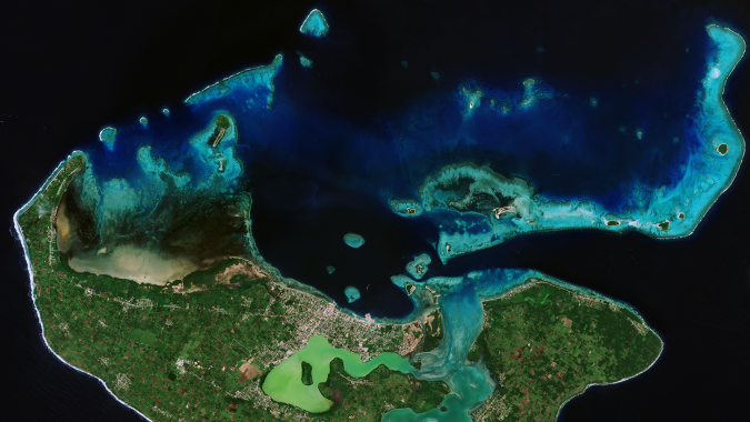 Satellite-derived bathymetry imagery, Tonga.
(Courtesy: EOMAP)2022The Seabed 2030 mission is paired with remarkable discoveries.
In the early months of 2022, it was revealed that satellite technology had been used to map the shallow seafloor of the Cook Islands with unprecedented detail.
This achievement was made possible through collaboration between scientists at the National Institute of Water and Atmospheric Research (
NIWA), Toitū Te Whenua Land Information New Zealand (
LINZ) and the satellite data analytics company EOMAP.
Kevin Mackay, a marine geology researcher at NIWA, leads Seabed 2030’s South and West Pacific Ocean Data Centre, one of the project’s four regional centres responsible for gathering and mapping data within their territories.
Speaking about the use of satellites to measure shallow ocean floors, he stated: “To measure the depth of the ocean, you would traditionally have to send out a boat with an echosounder, which costs a lot of money and can be dangerous in rough and shallow seas.
With satellites, we can access extremely remote locations, with a smaller carbon footprint and without having to endanger people.”
In March 2022, the UKHO signed a new MoU with the Nippon Foundation-GEBCO Seabed 2030 Project, following up on their June 2021 agreement.
Part of the new MoU was that the UKHO would provide bathymetric gridded map products to be used by the project within the GEBCO gridded bathymetric dataset.
The UKHO also promised to share and promote methods and best practices in technological innovation, infrastructure and solutions for ocean mapping and bathymetric data management.
In 2022, Seabed 2030 also partnered with the
Ocean Research Project (ORP) to advance the global effort of mapping the ocean floor, with a particular focus on polar regions through ORP’s expedition, GO-MARIE (Glacier-Oceans Mapping & Research Interdisciplinary Effort).
ORP, a non-profit organization dedicated to eco-friendly ocean discovery, conducts expeditions that enable small, specialized teams of researchers to collect critical data from remote and sensitive areas worldwide.
The GO-MARIE expedition marked the maiden voyage of ORP’s flagship, the RV Marie Tharp, a 22-metre Bruce Roberts steel schooner custom-built to navigate uncharted polar territories.
The vessel features a base crew of ten, with rotating ocean science experts joining different legs of the journey to contribute to this ambitious mapping mission.
Halfway through 2022,
Fugro became an associated partner of the European Marine Observation and Data Network (
EMODnet), a long-term EU initiative aimed at making diverse sources of marine data freely and uniformly available to all.
Beneficiaries of this work include policymakers, scientists, private industry and the public.
The Fugro‑EMODnet partnership was agreed with a focus on expanding private sector collaboration and marine data sharing in support of a sustainable blue economy.
This partnership’s activities tightly align with Fugro’s industry-leading involvement in the direct delivery of crowdsourced bathymetry acquired by Fugro for Seabed 2030 into the EMODnet data services.
The collaboration proved an excellent occasion to ramp up Fugro’s ongoing contribution to the Ocean Decade and Seabed 2030 global initiatives.
A month later, NOAA administrator Rick Spinrad signed an MoU during the United Nations Ocean Conference, officially formalizing US participation in Seabed 2030.
The agreement outlined best practices and protocols for data collection, fostering stronger collaboration among participating countries and partners.
By 2022, 23.4% of the ocean had been mapped, representing an addition of 10.1 million km2 (nearly 3.9 million square miles) of new bathymetric data compared to 2021.
The northern hemisphere summer also brought an announcement of a partnership with
Terradepth, made on the heels of the 2022 United Nations Ocean Conference in Lisbon, Portugal.
Terradepth’s Absolute Ocean portal provided Seabed 2030 with a secure platform to allow data contributors to visualize their contributions in an interactive way, and explore how they relate to other open source data in the platform.
In October 2022, survey data from a vast underwater valley off East Antarctica, collected during icebreaker RSV Nuyina’s first voyage, was publicly released through the national seabed mapping programme
AusSeabed.
The 2,300-metre-deep, 2,000-metre-wide and at least 55-kilometre-long valley, extending from beneath the Vanderford Glacier into the ocean, was mapped using Nuyina’s multibeam echosounder, which uses sound to build a visual picture of the seafloor.
Australian Antarctic data centre manager Dr Johnathan Kool said: “Through AusSeabed, the
Australian Antarctic Division and other partners are contributing jigsaw pieces to fill in the Australian seabed puzzle, which researchers and policymakers can then use to meet their needs.” Since data from AusSeabed also feeds into Seabed 2030, this was another promising step on the road to developing a definitive map of the world’s ocean floor by 2030.
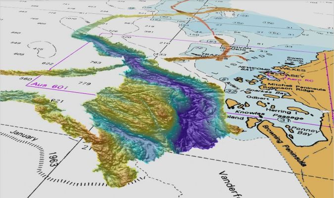
A false-colour image of the valley mapped using RSV Nuyina’s multibeam echosounder.
(False colour image: Geoscience Australia.
Chart: Hydrographic Material reproduced with permission of The Australian Hydrographic Office – Courtesy: Commonwealth of Australia 2022)
2023The year 2023 began with very good news for the Seabed 2030 Project, with the announcement that NOAA and two of Australia’s leading science agencies had signed an agreement to collaborate on Pacific Ocean exploration and mapping, in support of NOAA’s priorities and the objectives of the United Nations Decade of Ocean Science for Sustainable Development.
This effort also aligned with the broader goal of using science to enhance ocean health and support sustainable development.
In February, a strategic partnership with
ecoSUB Robotics, a subsidiary of Planet Ocean, was announced.
The AUVs developed by ecoSUB Robotics enable exploration of areas that are too dangerous for scientists and divers, making a valuable contribution to ocean mapping efforts.
AUVs are instrumental in accessing hazardous and remote, uncharted regions, providing an effective solution where traditional methods fall short.
They serve as a complementary tool to vessel-based surveys, enhancing ocean observation and improving the efficiency of data collection.
Also in February 2023, the Nippon Foundation-GEBCO Seabed 2030 Project announced that it would conduct a second online survey to identify global cumulative needs and priorities, and to inform the development of a benefits analysis and prioritization modelling for seabed mapping.
The survey seeked views from the wider global community of national government agencies involved in seabed mapping data acquisition, production and use.
TCarta expanded its involvement in the Seabed 2030 Project in March 2023.
While it had already contributed extensive SDB data to the effort, now the company started offering capacity-building initiatives to train international hydrographic offices in creating their own datasets for Seabed 2030 and other applications.
In April that year, Hydro International published an interview with Jamie McMichael-Phillips.
Considering the status of the global mapping effort at that moment, he explained: “We are very much limited by the speed with which ships can operate multibeam echosounder systems, which is one of the biggest challenges.
A vast amount of ocean still needs to be mapped.
Even if you take out the 23.4% I mentioned, we still have to map around 277 million km2 and incorporate it into the grid.
Broadly speaking, this is an area twice the size of Mars, nine times the size of Africa and 36 times the size of Australia.”
To the final question of the interview: “2030 is only seven years away; will you be on time?”, McMichael-Phillips answered: “We most certainly aim to achieve it, and we need the world to come together to help us get there.
We’ve grown enormously, from 6% in 2017 to 23.4% last year, and although the area that we still have to map is about twice that of Mars, look how far we’ve come.
Sure, it is going to take a lot of effort, but it is achievable.”
At
Ocean Business 2023, a partnership was agreed between Saildrone and Seabed 2030, entailing collaboration on advancing uncrewed ocean mapping technology in support of the global effort.
Prior to this announcement, Saildrone had mapped over 45,000km2 of previously unexplored ocean floor during a months-long survey around Alaska’s Aleutian Islands and off the coast of California.
In May 2023, the Nigerian Navy joined the Seabed 2030 Project, marking a significant step as the first collaboration of its kind in Africa.
The agreement included the potential deployment of up to 20 vessels from the Nigerian fleet, demonstrating the country’s commitment to advancing the initiative’s global mission.
The partnership was formalized during the 3rd Session of the IHO Assembly, where representatives from 98 Member States and observers convened to discuss advancements in ocean mapping and technical standards.
This milestone underscored the growing international cooperation essential for achieving Seabed 2030’s ambitious goals.
At this IHO gathering, another collaboration was born:
Norbit Oceans joined the initiative by providing innovative solutions involving a bathymetric survey dataset, research voyages and general survey activities.
In July 2023, it was announced that the
Memorial University of Newfoundland’s Marine Institute had entered into a partnership with the Seabed 2030 Project.
The Marine Institute is Canada’s most comprehensive centre for education, training, applied research and industrial support for the ocean industries, with studies available in the School of Fisheries, the School of Maritime Studies and the School of Ocean Technology.
The institute – which was established in 1964 and joined the university in 1992 – also boasts ‘The Launch’, a state-of-the-art marine living lab that offers a safe, reliable, near-Arctic environment to test new technology, train in harsh conditions and explore the next advances in ocean research.
“The Marine Institute’s world-class expertise and research capabilities will greatly support our mission here at Seabed 2030,” commented McMichael-Phillips.
Jamie McMichael-Phillips: "The biggest game-changer has been uncrewed technology."
In October 2023, Hydro International published the article ‘Pioneering ocean mapping for a better world’, contributed by Jamie McMichael-Phillips and David Millar, the latter serving as Fugro’s government accounts director for the Americas and member of the GEBCO Guiding Committee.
In the year that GEBCO, the only organization with a mandate to compile global bathymetry data, celebrated its 120th anniversary, the authors wrote: “When Seabed 2030 was launched in 2017, only 6% of the ocean had been mapped to modern standards.
This figure has grown considerably, with just under a quarter – 24.9% – of the entire ocean floor now charted in the GEBCO grid.” The article zoomed in on Fugro’s success with its own data development and sharing programme.
“This was made possible by early investments in remote command-and-control technology, which allowed the company to collect high-resolution bathymetry while travelling to and between projects.
Fugro’s philanthropic ‘in-transit’ bathymetry programme started in the Americas region with just one survey vessel in 2016.
Today, nine of the company’s global survey vessels are participating, with contributions of Fugro bathymetry now totalling more than 2.36 million km².
By 2025, the company aims to have 90% of its global fleet collecting in-transit bathymetry in support of Seabed 2030.”
The article highlighted a clear trend towards remote and autonomous technologies in ocean mapping.
When Seabed 2030 was first envisioned, robotic ocean surveys were non-existent.
Now, however, USVs collecting deepwater bathymetry are an established reality.
A key factor in this progress has been collaboration, exemplified by the
Shell Ocean Discovery XPRIZE – a global, three-year competition that spurred the development of uncrewed, high-resolution ocean mapping technologies.
One notable outcome was the
SEA-KIT USV, now deployed by Fugro across Europe, Australia and the Middle East.
The focus has shifted to scaling these USV and other autonomous technologies within the industry, McMichael-Phillips and Millar wrote.
By expanding their capabilities, the goal is to enable high-resolution mapping of entire ocean basins for regional partners in a way that is safe, efficient and environmentally responsible.
In November 2023,
FarSounder started teaming up with the Nippon Foundation-GEBCO Seabed 2030 Project to advance the collective understanding of the ocean floor in pursuit of the complete map of the entire seabed.
This collaboration coincided with FarSounder’s Small Business Innovation Research (SBIR) Phase I grant awarded by the NOAA.
This award provided funding for the research and development of a new project to develop a cloud-based service to share survey data collected by FarSounder customers.
The project – titled ‘Enabling Expanded Crowdsourced Bathymetry Contributions With High-Quality Metadata via Commercially Sustainable Incentives to Contributors’ – allowed for data sharing with others across the FarSounder customer fleet and with Seabed 2030 via the IHO’s
Data Centre for Digital Bathymetry (DCDB), which archives over 30 terabytes of oceanic depth soundings and serves as the long-term archive for Seabed 2030.
 Areas of the global seafloor that are considered mapped within the GEBCO grid.
The regions coloured grey depict the coverage of mapped areas within the 2022 release of the GEBCO grid and the areas coloured red show the additional coverage included in the 2023 release.
(Image courtesy: The Nippon Foundation-GEBCO Seabed 2030 Global Center)2024In February 2024, Schmidt Ocean Institute announced that the crew aboard its research vessel Falkor (too) had discovered
four underwater mountains during a transit from Golfito, Costa Rica, to Valparaiso, Chile.
The tallest of these seamounts rose over 2.4 kilometres, with heights ranging from approximately 1,591 metres to 2,681 metres.
This followed their November 2023 discovery of an underwater mountain measuring 1,600 metres – twice the height of the Burj Khalifa – in international waters off Guatemala.
Marine technicians and hydrographic experts John Fulmer and Tomer Ketter confirmed the newly identified seafloor features using multibeam mapping, noting that none of them appeared in existing bathymetric databases.
These discoveries were made while plotting a course to investigate gravity anomalies along the route, where subtle changes in the ocean surface – caused by variations in seafloor topography – offered clues.
A trench creates a slight surface depression, while a seamount produces a barely noticeable rise, helping experts to refine seafloor maps.
“These remarkable discoveries by Schmidt Ocean Institute underscore the importance of a complete map of the seabed in our quest to understand Earth’s final frontier,” said Jamie McMichael-Phillips.
In May 2024, the research icebreaker Polarstern returned to its home port of Bremerhaven, Germany, after a successful Antarctic season.
The expeditions to the southern hemisphere and the transit there focussed on the oceanography and geology of East Antarctica as well as student training.
As the Polarstern began its return transit through the Atlantic under the leadership of Simon Dreutter, it commenced the collection of valuable seabed survey data.
Together with a small team from the
AWI (Alfred-Wegener-Institut) bathymetry department, Dreutter used the ship’s own soundings to map the seabed for the GEBCO Seabed 2030 Project.
In June,
Challenger 150, a global initiative dedicated to mapping deep-sea life, signed an MoU with Seabed 2030.
Challenger 150 is a global scientific cooperative under the
Deep Ocean Stewardship Initiative (DOSI).
It was developed in response to the needs of the Ocean Decade, aiming to build capacity for global deep-sea research, expand biological observations, enhance understanding of deep-sea ecosystems and support their sustainable management.
Dr Ana Hilario, deep-sea ecologist at the University of Aveiro and fellow co-lead of the Challenger 150 programme, said: “By combining the high-resolution bathymetric data compiled by initiatives such as Seabed 2030 with our own, we can produce unprecedented ecosystem maps and predictive habitat models.
This is incredibly exciting as it means we can fill the big holes in our knowledge of the deep sea and better target where to look for key ecosystems.
The collaboration will also help us produce a ‘digital twin’ of the ocean, so that we can better understand the impacts of climate change and human use.”
In September 2024, an MoU was signed with
Exail, marking the beginning of a collaborative partnership with Seabed 2030.
Together, they will work to advance their shared objectives by exchanging knowledge and best practices in ocean mapping and bathymetric data management.
As part of this collaboration, Exail will contribute bathymetric data, leverage its advanced technologies to support the Seabed 2030 vision, and actively engage with users of its sonar, navigation and autonomy solutions to further promote the initiative.
At the close of 2024, Seabed 2030 secured two significant and high-profile partnerships, further emphasizing the critical importance of its mission.
Hexagon – a global leader in advanced digital solutions and a champion of innovation – emerged as a potentially transformative addition, poised to become an indispensable partner in the quest to create a comprehensive map of the ocean floor.
The second key addition was
Woolpert, renowned for its expertise in hydrography, surveying and geospatial solutions, combined with its forward-thinking application of cutting-edge technologies.
Both partnerships were formally announced during Seabed 2030’s Pacific Ocean Mapping Meeting held in Fiji.

In
January 2024, Schmidt Ocean Institute experts recently uncovered the largest of four seamounts, towering at 2,681 metres tall, spanning 450 square kilometres, and resting 1,150 metres below the surface.
(Image courtesy: Schmidt Ocean Institute)
Ambassador for hydrography
The Seabed 2030 Project serves as a fantastic ambassador for the hydrographic sector.
A great example is the summer-long paid
SDB internship in which six students took part and that was facilitated by TCarta and hosted at the Marine Institute (MI) of Memorial University in St.
John’s, Newfoundland.
All participants were either recent graduates or current students in the MI Ocean Mapping programme.
The programme’s mobilization was a collaborative effort between TCarta, Memorial University and Seabed 2030.
The student interns successfully produced 39,304km² of 10m-resolution SDB across four areas of interest worldwide, within just eight weeks.
The SDB was generated for the coastlines of Somalia, the Mosquito Coast, the Galapagos and the islands of the Lesser Antilles.
This bathymetry will be contributed to the Seabed 2030 initiative, just as last year’s internship results from Madagascar, Newfoundland and the Canadian Arctic were.
Recognizing collaborationGiant strides continue to shape the mission as countless partners join forces, with much still left to achieve.
While many contributors have been acknowledged in this article, the list is far from complete – numerous other partners play invaluable roles in advancing the mapping of the ocean floor.
On World Hydrography Day 2024, the Nippon Foundation-GEBCO Seabed 2030 Project celebrated a significant milestone: 4.34 million km2 of new ocean floor have been mapped – an area roughly the size of the European Union.
With 26.1% of the ocean floor now charted, these achievements underscore groundbreaking advancements in seafloor mapping technologies and the collective power of collaboration.
Beyond increasing the mapped area, the discoveries made through this effort are essential for sustainably exploring and managing Earth’s final frontier.
Completing the project by 2030 remains a significant challenge, but the initiative has garnered widespread recognition and enthusiastic support, drawing praise from many quarters.
In December 2024, it was announced that Seabed 2030 had been selected as one of ten global projects for the prestigious Paris Peace Forum’s Scale-up Program (
SCUP) for 2024–2025.
This honour, revealed during the Forum’s seventh edition, underscores Seabed 2030’s critical role in enhancing our understanding of the ocean – key to tackling global issues such as biodiversity loss and climate change, which will take centre stage at next year’s Forum.
Steve Hall, head of partnerships for Seabed 2030 and representative at the Forum, expressed excitement about the recognition: “We are thrilled that Seabed 2030 has been selected for the Paris Peace Forum’s SCUP.” He explained that this support perfectly aligns with the initiative’s mission to accelerate global ocean mapping, a necessity not only for biodiversity protection and climate action but also for unlocking countless other benefits.
Hall emphasized the opportunity to collaborate with the Paris Peace Forum community to expand the project’s reach and amplify its impact.
Links :- Geosciences, 8(2), 63. Mayer, L., Jakobsson, M., Allen, G., Dorschel, B., Falconer, R., Ferrini, V., Lamarche, G., Snaith, H., & Weatherall, P. (2018). The Nippon Foundation—GEBCO Seabed 2030 Project: The Quest to See the World’s Oceans Completely Mapped by 2030.
- Haarsma, D. (2023, April 26). Seabed 2030 speeding up to meet its decade target, Hydro International.
- McMichael, J., & Millar, D. (2023, October 6). Pioneering ocean mapping for a better world, Hydro International
- GeoGarage blog: Tropical seafloor secrets discovered as seabed 2030 gains ... /
An ambitious project aims to map the entire ocean floor. It ... /
The mighty quest to unveil our blue planet /
Can scientists map the entire seafloor by 2030? /
Can a map of the ocean floor be crowdsourced? /
Mapping quest edges past 20% of global ocean floor /
Earth's final frontier: the global race to map the entire ... /
Mappers look to chart world's ocean floor by 2030 /
Nearly a quarter of Earth's seafloor now mapped /
Why the first complete map of the ocean floor is stirring ... /
Why mapping the entire seafloor is a daunting task, but key ... /
'The Deepest Map' explores the thrills — and dangers /
The ocean is deeper than you think. We need better maps. /
Massive new seamount discovered in international waters ... /
Mapping the mysteries—and the dangers—of the ocean ... /
New depth map of the Arctic Ocean /
Model suggests undersea mountains help mix the global ... /
NOAA Ocean Exploration meets major mapping milestone /
The quest to map the mysteries of the ocean floor /
Which countries are mapping the ocean floor? /
To predict future sea level rise, we need accurate maps ... /
Underwater drones nearly triple data from the ocean floor /
Four new seamounts discovered in the high seas /
New seamount and previously unknown species ... /
Oceans' extreme depths measured in precise detail