A great white shark is struck by a boat — and I capture the moment on camera.
This may be the first time such an incident has been documented in real time.
In this video, I break down the shark’s behavior before and after the impact, assess the injury, and reflect on what this means for white shark survival in human-dominated waters.
Filmed off the coast of California, this is a rare and sobering look at the reality great whites face today.
In rare footage, a boat is captured smashing into a great white shark off the Southern California coast…resulting in a serious injury.
Shark sightings off Southern California are quite common.
Particularly in the summer months, the lower half of the Golden State is a hotbed of juvenile great white activity – thanks to the warm water and buffet of food including stingrays and fish.
Carlos Gauna, aka The Malibu Artist, documents and studies the abundance of great white shark action in Southern California, often spotting the creatures mingling amongst surfers and swimmers via drone, while also providing insights into their behavior.
But recently, Gauna captured something he’s never seen before – perhaps something documented for the first-time ever.
Gauna shows a great white shark being struck by a boat passing by above. And the shark suffers significant injuries from the collision.
It’s a tough watch, because the shark is clearly hurt – a large gash, presumably from the boat’s propeller, showing on its tail. “These creatures are built for survival,” Gauna narrates.
“But even they are vulnerable, because out here, in an ocean shared with people, they’re not immune to the fast pace of human activity. This fast-moving boat caught my attention as it approached. It was headed in the same direction that I had been filming the shark just minutes earlier.”
With all the space in the vast ocean, somehow, the boat collided with the shark.
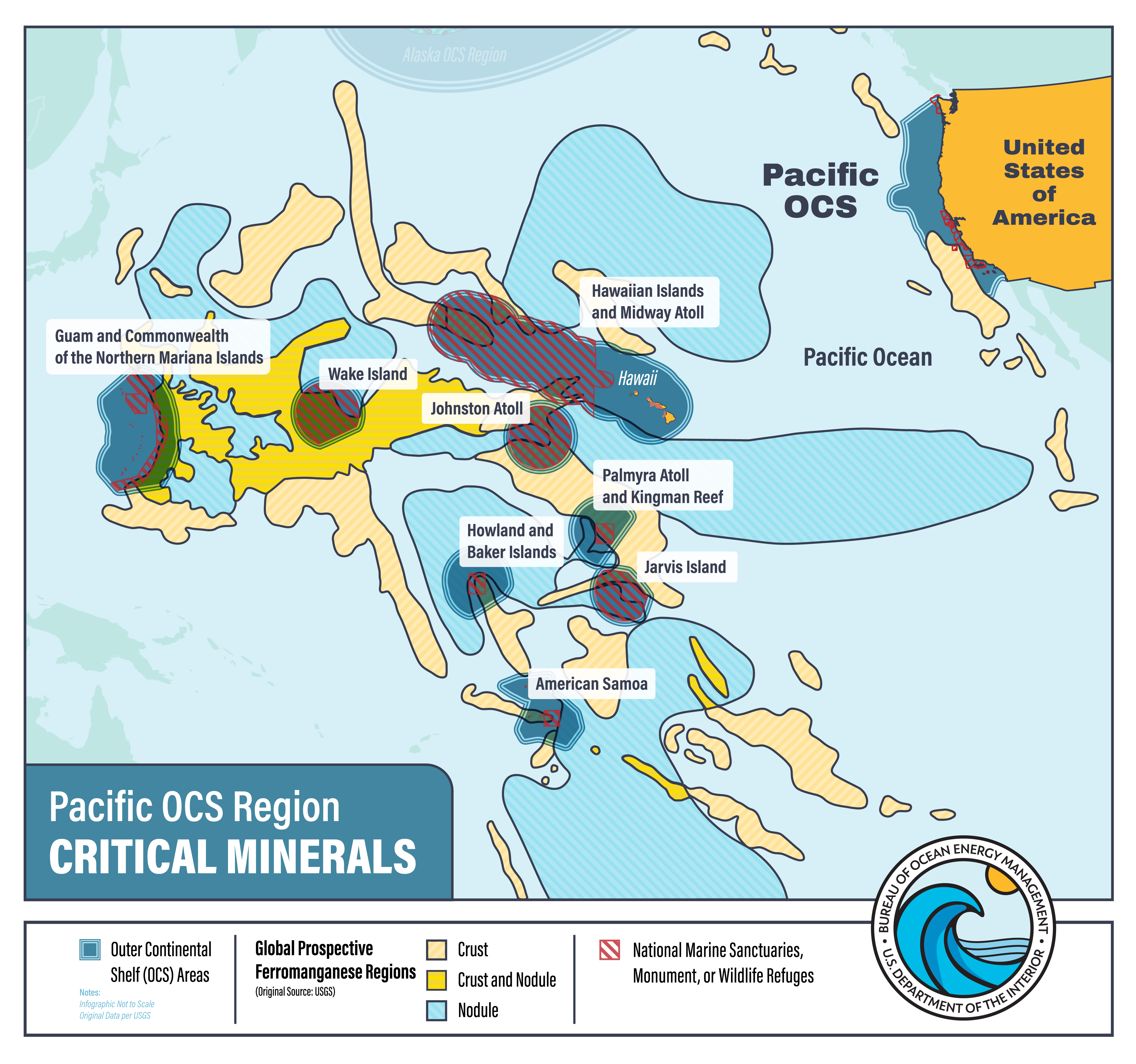
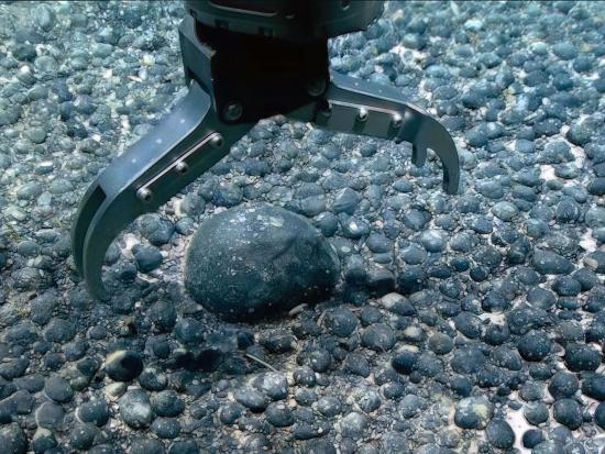
The U.S. Department of the Interior has taken a significant step towards exploring critical mineral resources in the waters surrounding American Samoa, a move that could reshape the maritime industry’s approach to resource extraction and environmental stewardship. On June 12, 2025, the Department announced its intent to publish a Request for Information and Interest (RFI) for commercial leasing of the Outer Continental Shelf (OCS) seabed in the region. This action, initially published in the Federal Register on June 16, 2025, has sparked a 30-day public comment period, which has since been extended to August 15, 2025, following a request from the Governor of American Samoa.
The Bureau of Ocean Energy Management (BOEM) is leading this initiative, emphasizing its commitment to an inclusive and transparent process. “As we extend the comment period, we emphasize our commitment to an open process that ensures the voices of the people of American Samoa are heard and respected,” said Doug Boren, BOEM Pacific Regional Director. “We look forward to our continued engagement with the Government of American Samoa.” This extension underscores the importance of local input in shaping the future of offshore mineral development.
The Department of the Interior has made it clear that any future lease sale will be subject to rigorous environmental review under the National Environmental Policy Act. Additionally, the process will comply with all applicable laws, including the Endangered Species Act and the National Historic Preservation Act. This commitment to environmental and cultural preservation is crucial, given the sensitive ecosystems and historical significance of the region.
This development builds on the Department’s May 2025 action to evaluate new opportunities for critical mineral development, as directed by President Trump’s Executive Order on Unleashing America’s Offshore Critical Minerals and Resources. The focus on critical minerals, such as rare earth elements, is driven by the growing demand for these resources in various industries, including renewable energy, electronics, and defense.
The potential implications of this initiative are far-reaching. For the maritime industry, it represents an opportunity to diversify its portfolio and tap into new revenue streams. However, it also comes with significant challenges, including the need for advanced technology and expertise to extract minerals from the seabed safely and sustainably. The environmental impact of such activities will be a critical factor, and the industry must be prepared to address these concerns head-on.
Moreover, this move could set a precedent for similar initiatives in other regions, both within the U.S. and internationally. As the demand for critical minerals continues to rise, governments and industries worldwide may look to the American Samoa project as a model for balancing resource extraction with environmental and cultural preservation.
The extension of the comment period is a positive sign, indicating that the Department of the Interior is taking the concerns of local communities seriously. This inclusive approach is essential for building trust and ensuring the long-term success of any future projects. It also highlights the importance of public engagement in shaping policies that affect local communities and the broader maritime industry.
In the coming months, stakeholders, including industry representatives, environmental groups, and local communities, will have the opportunity to voice their opinions and concerns. The feedback gathered during this process will be instrumental in shaping the final decision and ensuring that any future leasing activities are conducted responsibly and sustainably.
As the maritime industry watches this development closely, it is clear that the outcome of this initiative could have significant implications for the future of offshore mineral extraction. The balance between economic development and environmental stewardship will be a key factor, and the industry must be prepared to adapt to new regulations and technologies to meet these challenges.
In conclusion, the U.S. Department of the Interior’s move to explore critical mineral resources in American Samoa’s waters is a significant step that could reshape the maritime industry. The extension of the comment period underscores the importance of local input and sets a positive precedent for future initiatives. As the industry navigates this evolving landscape, it will be crucial to prioritize sustainability, innovation, and community engagement to ensure the responsible development of these valuable resources.
Rise of aquatic autonomy echoes Mexico’s evolving drone playbook
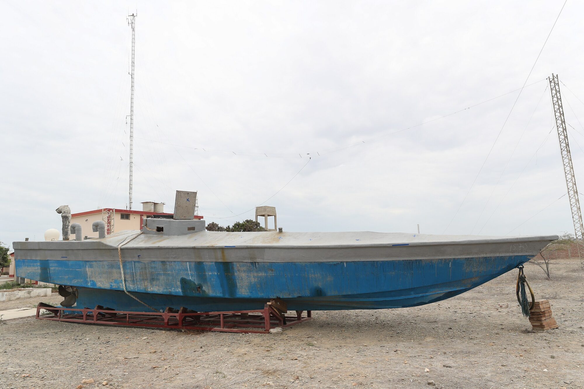
BOGOTÁ, Colombia — In what Colombian officials are calling a technological shift in the drug war, the country’s navy last week announced the seizure of an uncrewed semisubmersible narco-submarine — the first of its kind discovered in Colombian waters.
The craft, found off the Caribbean coast near Santa Marta, contained no cocaine and no crew, but was outfitted with a Starlink satellite modem, antennas, and dual surveillance cameras— one for navigational awareness and another monitoring internal systems. Authorities believe the vessel was on a trial run for transporting narcotics, likely intended for the U.S. or European markets.
“The discovery reflects a migration toward more sophisticated unmanned systems that increase evasion capabilities,” said Adm. Juan Ricardo Rozo Obregón, commander of the Colombian Navy.
Cartels Look To Aquatic UAS
The emergence of a drug-running sub without human operators marks a turning point in the evolution of narco trafficking. While low-profile semisubmersibles have been used by criminal organizations since the 1990s, the integration of autonomy represents a new level of sophistication. The vessel is believed to be operated by the Gulf Clan, Colombia’s largest drug cartel. Authorities say these autonomous systems allow traffickers to remove onboard personnel, cutting risks and complicating efforts to prosecute those responsible. “The fewer people onboard, the fewer links in the chain,” said Sergio Guzmán, director of Colombia Risk Analysis. “It’s a direct response to years of interdiction and international intelligence sharing.”
Echoes of Mexico’s Drone Evolution
The move mirrors tactics used by Mexican cartels in urban warfare, where uncrewed aircraft systems (UAS) have evolved from crude hobby drones to modified aerial IEDs and surveillance tools, often deployed in urban combat or used to monitor rival groups and police. Like in Mexico, these maritime adaptations are shaped by access to cheap electronics, satellite internet, and off-the-shelf tech — the same toolkit that’s helped cartel UAS operations flourish in conflict zones like Michoacán and Guerrero. A 2023 analysis found that cartels were repurposing drone tech in increasingly militarized ways. In that same spirit, Colombia’s uncrewed subs now signal a similar trajectory — but underwater.
Investing in R&D, Not Just Risk
While the seized sub was empty, investigators believe its value lies in field testing rather than cargo delivery. Narco engineers, some allegedly contracted as early as 2017 by Mexican organizations operating in Colombia, are prioritizing research and development to future-proof drug logistics.
“This unmanned model seems like the next step in that evolution,” said Henry Shuldiner of InSight Crime, who co-authored a report on narco-submersibles. “The fact that this appeared to be a test run shows traffickers are willing to lose a vessel to gain long-term operational knowledge.” Estimates suggest uncrewed semisubmersibles can cost anywhere between $150,000 and $2 million, depending on sophistication. By eliminating human life, traffickers reduce liability while increasing operational reach.
The cocaine trade is far bigger and more geographically diverse than at any other point in history with some groups opening up underwater smuggling routes from South America as far as Europe and Australia, using homemade narco submarines.
In 2019, the first narco sub in Europe was found off the coast of the Spanish region of Galicia after a 27-day journey across the Atlantic.
WSJ explores how drug cartels are evading authorities using submersibles to deliver record-breaking shipments worth billions of dollars around the world.
Colombia’s navy reported detecting 10 semisubmersibles in the first half of 2025, many modified to reduce radar signatures or operate partially autonomously. In 2024 alone, authorities globally intercepted nearly 30 of these stealth vessels — but experts believe that number represents just a fraction of the true traffic. “U.S. estimates suggest only 5% of narco-subs are actually intercepted,” Shuldiner added. “That means hundreds could be slipping through undetected every year.” While container ships still carry the majority of cocaine shipments, narco-subs have become increasingly vital for transoceanic routes, especially as law enforcement expands container scanning operations in major ports.
A narco-submarine captured by the Peruvian Navy in December 2019
Global Surge in Production Meets Maritime Innovation
The shift to autonomous drug transport comes amid record-high cocaine production in Colombia, with coca cultivation jumping from 204,000 hectares in 2022 to 253,000 hectares in 2023, according to the United Nations. Globally, cocaine use rose to 25 million people in 2023 — up from 17 million just a decade ago. This has emboldened cartels to pursue higher-risk, high-reward strategies. Maritime drones, like their airborne cousins in Mexico, represent a long-term bet on stealth, scale, and deniability.
Outpaced on the Water
Despite legal penalties — including up to 14 years in prison for operating or building semisubmersibles in Colombia — officials acknowledge that enforcement is lagging. “This was the first capture of its kind,” Guzmán said. “But that doesn’t mean it was the first deployment. Authorities are a step behind.” As cartels increasingly weaponize autonomy and exploit undersea routes, the challenge for governments will be cooperation and adaptability — and not just at the national level. “Unless we improve real-time information sharing,” Guzmán warned, “we’ll always be reacting, not preventing.”
🇨🇴 | Unmanned narco subs, such as the vessel recently captured in Colombia, reduce recruitment costs and legal liabilities for drug traffickers. But impunity for the groups behind drug subs is already high, as our recent investigation explains. https://t.co/oFeBzp3umppic.twitter.com/oa3JjWrfG3
In the oceans, the most widespread type of plastic pollution may be the kind you can’t see.
A new study published Wednesday in the journal Nature estimates that the North Atlantic Ocean alone contains 27 million metric tons of nanoplastic — plastic particles 100 times smaller than the width of a human hair. That figure is 10 times higher than previous estimates of plastic pollution of all sizes across all the world’s oceans, according to the study’s authors.
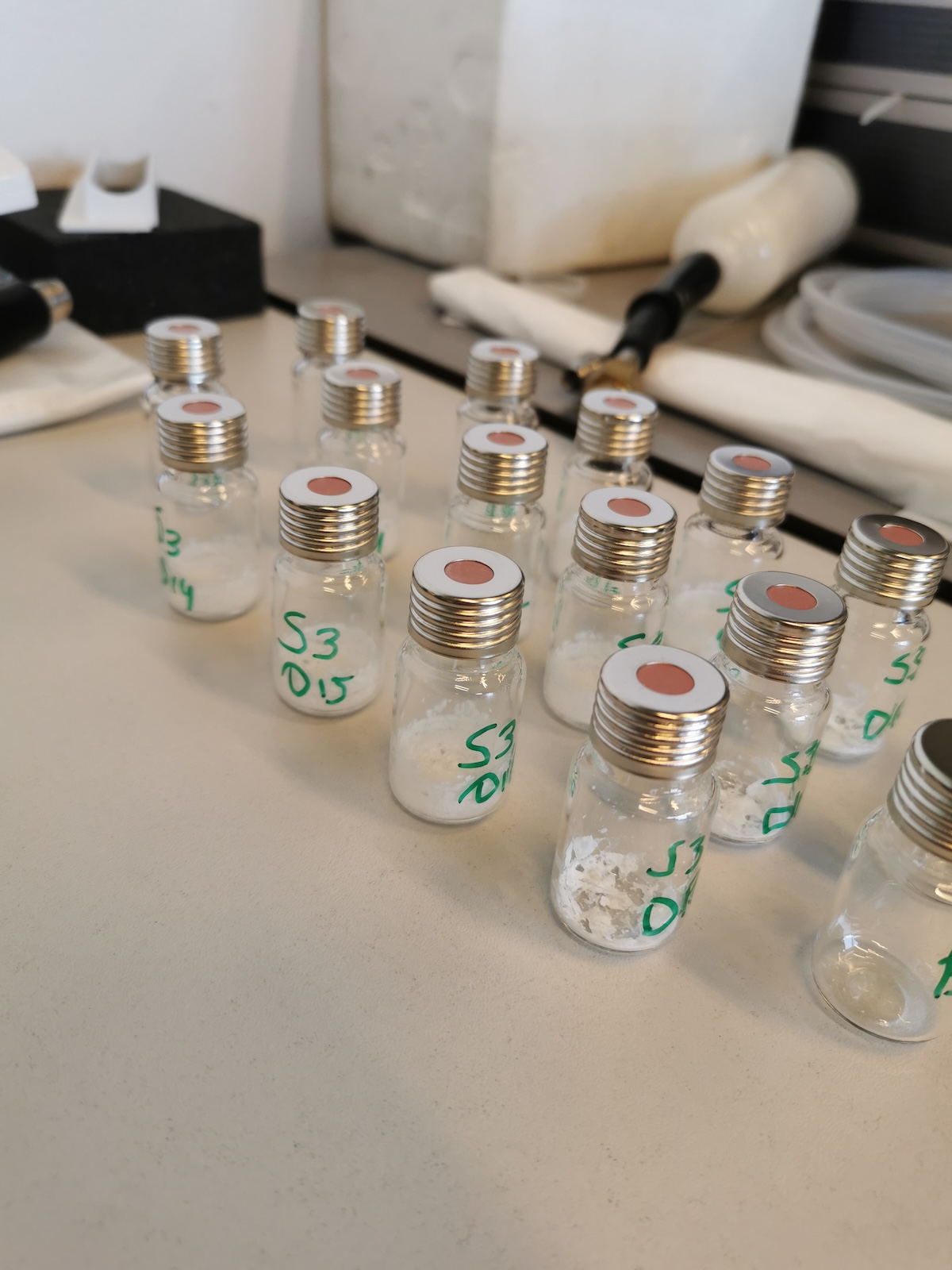
Glass vials containing nanoplastic samples from each of the 12 locations tested.
Salt residue is visible at the bottom of each.
Courtesy of NIOZ
The research represents one of the first attempts to quantify marine nanoplastic pollution; previous efforts were constrained by limitations in detection technology. The study suggests that the mass of nanoplastics in the North Atlantic is greater than that of their much larger counterparts, microplastics and macroplastics. Microplastics range in width between 0.001 millimeters and 5 millimeters, making them up to 5 million times bigger than nanoplastics. Macroplastics are even larger.
Helge Niemann, a researcher at the Royal Netherlands Institute for Sea Research, a professor of geochemistry at Utrecht University, and one of the study’s authors, said the findings are concerning for marine biology and human health. Nanoplastics are “not conducive, generally, for life,” he told Grist. He emphasized that the study’s findings are limited to the North Atlantic, but said it is “likely the case” that nanoplastics are widespread across other oceans as well.
Studies suggest that nanoplastics cause inflammation to living cells when ingested, though it’s unclear whether this is because of the particles themselves, the plastic chemicals they can release, or pathogens that they pick up while floating around in the environment. Due to their tiny size, nanoplastics can more easily traverse biological membranes than their larger counterparts.
Tracey Woodruff, a professor of reproductive health and the environment at the University of California, San Francisco, who was not involved in the new research, said she expects that nanoplastics will be linked to many of the same health risks as microplastics. In animals, these include reproductive issues, intestinal problems, and colon and lung cancer. Microplastics also bioaccumulate, meaning they travel up the food chain as larger animals eat smaller ones.
“Our hypothesis is that … nanoplastics could travel more widely in the body even than microplastics, and therefore could have more adverse health consequences,” Woodruff said. It’s also possible that future research will discover that nanoplastics are present in the human body at even higher concentrations than microplastics.
The study’s authors obtained their data during a research cruise in 2020. They collected water samples at 12 locations of varying depths across the North Atlantic Ocean. Five samples were taken from within the North Atlantic gyre, one of the world’s five circular ocean currents that has become famous for its “garbage patch,” an enormous collection of plastic trash and other waste.
The researchers looked at nanoplastic concentrations at three different depths at each location: a layer just 10 meters below the surface, a middle layer at 1,000 meters deep, and 30 meters above the seafloor. Back in the lab, they used a novel type of mass spectrometry — an analysis that can identify different kinds of plastic — to distinguish between three polymers. Polyethylene terephthalate, or PET, the type of plastic used in water bottles, was the most widespread at every depth, followed by polyvinyl chloride, used in water pipes, upholstery, children’s toys, and other products; and polystyrene, used in plastic foam.
Overall, nanoplastic concentration was the highest closer to the surface at 18 milligrams per square meter and lowest near the seafloor at about 5.5 milligrams per square meter. The researchers suspect that this distribution is due to the deterioration of bigger pieces of plastic that are suspended near the surface, which may sink slowly unless transported downward by, for example, animals that have eaten plastic and then died.
Eighteen milligrams per square meter might not seem like much. But, it’s the equivalent of containing seven mosquitoes in a 3-foot by 3-foot box, assuming each mosquito weighs roughly 2.5 milligrams. Multiply that by the vast volume of an ocean, and you end up with a whole lot of plastic.
“I would argue as a toxicologist that if you see something in micrograms per liter in the open ocean, that’s quite a high concentration,” said Martin Wagner, a biology professor at the Norwegian University of Science and Technology who was not involved in the study.
Wagner cautioned that the study’s major extrapolation — that there are 27 million metric tons of nanoplastic in the North Atlantic, more than the weight of 26,000 Eiffel towers — relies on “very few samples.”
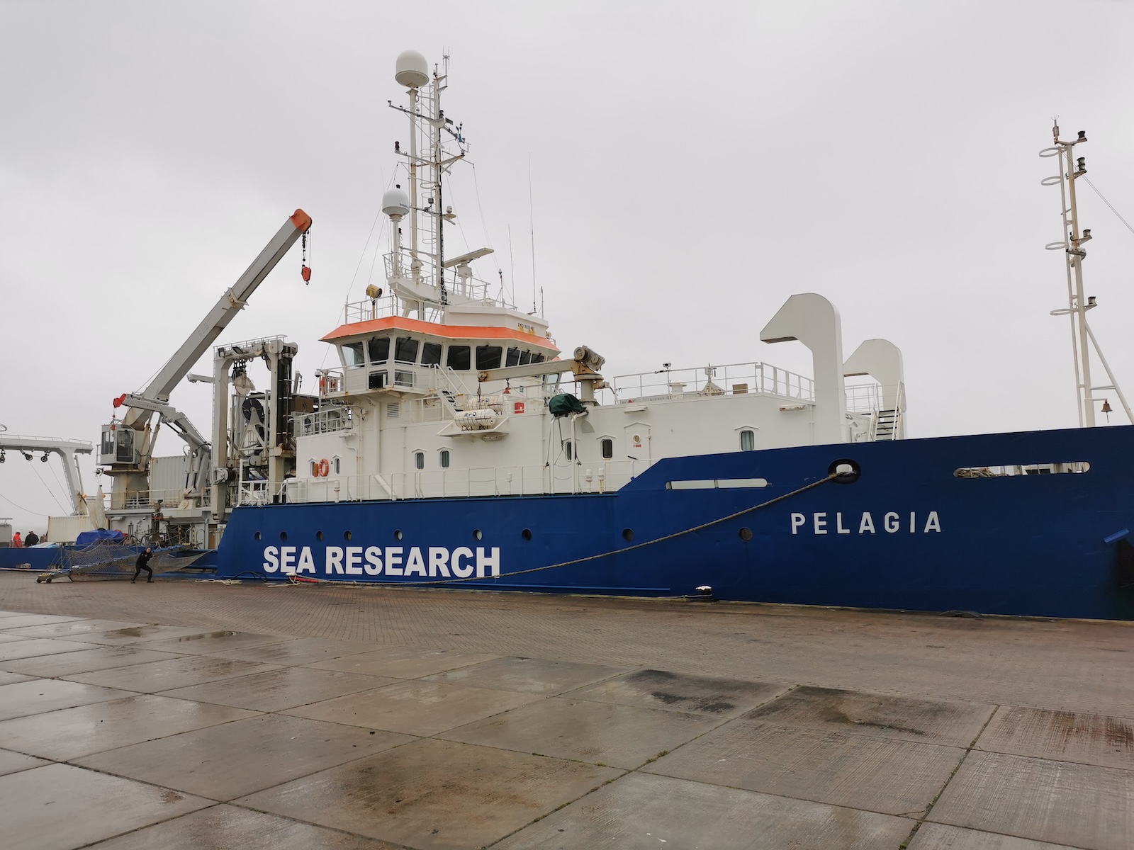
The study authors collected samples during a 2020 cruise
aboard the Pelagia, a research vessel.
Courtesy of NIOZ
Still, Wagner said it makes sense that there would be an exorbitant amount of nanoplastic given the high volume of larger plastic fragments that end up in the oceans each year. According to the United Nations, roughly 20 million tons of plastic enter aquatic ecosystems each year. This includes lakes, rivers, and streams, as well as oceans, but for much of that pollution, the ocean is the final destination.
“We’ve basically been dumping plastic in the ocean for decades,” Woodruff said. “It doesn’t go away, it just breaks down into smaller plastics, so it does make sense that you would find more nanoplastics than macro and microplastics.”
Notably, the type of analysis that the study’s authors used was unable to detect the world’s two most common plastic polymers: polyethylene and polypropylene, meaning their estimate for overall nanoplastics is likely conservative. Still, the study’s findings could provide more realistic data for researchers who are trying to model the real-world impacts and toxicity of nanoplastic pollution.
Niemann said more research is needed on nanoplastics, including on their prevalence globally. He recently won a grant to research what happens to nanoplastics once they’re in the ocean, including whether any types of bacteria can naturally break them down. Manually trying to clean them from the global oceans’ more than 330 million cubic miles of water is “not really a good idea,” he said.
Both Wagner and Woodruff said the research adds to the growing body of evidence supporting limits on global plastic production — rather than allowing it to triple by 2050, as projected by the United Nations Environment Programme. World leaders are expected to continue debating plastic production limits during the next round of negotiations over the U.N.’s plasticstreaty, scheduled to take place next month in Geneva, Switzerland.
“This reinforces how important it is to cap [plastic production], leave fossil fuels in the ground, and look to alternatives,” Woodruff said.
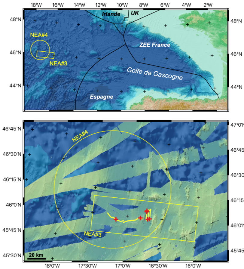
Location of areas in the North-East
Atlantic abyssal plain where radioactive drums (NEA#3 and #4) were
dumped in international waters (top).
The detailed map (bottom) shows
the available bathymetry, as well as the location of the 6 drums (red
crosses) identified by the submersible Epaulard during dives in 1985
(these identifications were made as part of the CEA/IPSN and IFREMER
EPICEA campaign).
Between 1950 and 1990, over 200,000 barrels of radioactive waste were dumped in the depths of the Northeast Atlantic Ocean. The first mission of the NODSSUM cruise, taking place from June 15 to July 11 and led by the CNRS, will map the primary sites for submerged barrels and study their interactions with marine biodiversity. The second mission will target the immediate vicinity of the barrels.
The interdisciplinary NODSSUM mission led by the CNRS in collaboration with a team from Ifremer, the ASNR, and multiple national and international partners will take to the seas on 15th June for one month. The scientists have planned two cruises, deploying modern tools to map and study the primary sites where numerous barrels of radioactive waste were voluntarily dumped for 40 years at the Abyssal Plains of the Northeast Atlantic. This first scouting mission is being conducted with the Ulyx robot of the French oceanographic fleet, operated by IFREMER.
Between 1946 and 1990, over 200,000 barrels of radioactive waste were dumped by multiple European countries in the international waters of the Abyssal Plains in the Northeast Atlantic Ocean, at a depth of over 4,000 metres. These barrels contain waste embedded in asphalt or cement.
The Ulyx robot photographed the barrels at a depth of over 4,000 m.
Here we see an abyssal fish and its shadow.
(Photo French oceanographic fleet - Nodssum campaign)
The NODSSUM project, an interdisciplinary cruise including nuclear research, geology, oceanography, biology, and marine chemistry, will map the primary dumping zone and study the behaviour of radionuclides in the deep ocean, in addition to their interactions with marine ecosystems. For one month, scientists will crisscross the dumping sites of radioactive barrels using high-resolution sonar on board the new autonomous submersible UlyX, which will complete its first scientific dives. It will navigate at approximately 70 metres above the seafloor to map and identify barrels, and will approach to a distance of 10 metres to photograph them. This will help identify the sites for initial water, sediment, and faunal samples without approaching the barrels.
For this first interdisciplinary mission, the scientists combine multiple cutting-edge technologies, and plan to take sediment samples on board the ship using corying systems, and water using a rosette sampler. Currentmeters will be deployed at the seabed to measure the Abyssal Zone’s currents. The scientists will also install traps for fish and crustaceans to determine the effect of this radioactive waste on marine life and ecosystem dynamics. On board the ship, the teams will have access to radioactivity measurement instruments for the first assessment, later be refined with more extensive analyses in the laboratory on-land.
To avoid any potential radiological risk, the project includes robust onboard radioprotection measures. From the moment of their arrival, the samples and instruments will be checked and controlled, implementing appropriate radioprotection measures for sample handling and storage. This precautionary effort will be applied and adapted throughout the scientists’ activities, including in laboratories back on firm ground.
These measures and samples will help identify the sites to be more closely studied during a second future cruise, whose goal is to target the immediate vicinity of the barrels. This will be carried out with either a manned submersible, or a remotely operated robots, equipped with mechanical arms to directly observe the barrels and handle sampling nearby.
The interdisciplinary NODSSUM mission is an integral part of the PRIME RADIOCEAN project led by the CNRS, in connection with the NODSSUM project being pursued with the French Oceanographic Fleet.
Notes :
UlyX is the new autonomous underwater vehicle (AUV) of the French Oceanographic Fleet (FOF).
This autonomous marine robot conducts missions with no help from a pilot. It is an active explorer thanks to its data analytics algorithms, which allow it to change trajectory depending on the signs it detects. UlyX is powered by batteries that can descend to a depth of more than 6,000 meters.
A radionuclide is an atom whose nucleus is unstable, and that can potentially transform into another atom by emitting radiation.
Waste contains a series of radionuclides, each with its own properties.
Beyond their quantity, they can be present in different forms that are more or less mobile, divided between the water and sediments. Some radionuclides are produced by humans, such as caesium-137, while others are present naturally, such as potassium-40 and lead-210. Radionuclides are present everywhere. In general, exposure to ionizing radiation primarily comes from natural sources (radionuclides from the Earth’s crust, cosmic radiation).
This is an 1871 Augustus Petermann map of Svalbard and the Arctic Ocean. The map records the 1868 First German North Polar Expedition, which, to this day, maintains the records for the highest northern latitude reached by a sailing ship without auxiliary drive.
A Closer Look
Illustrating the 1868 First German North Polar Expedition, the map depicts the region from Svalbard south to the Shetland Islands and from Iceland and Greenland to Norway. The expedition's track is highlighted using color to differentiate months. The crew recorded water temperature readings every four hours, dated along the expedition's course. Part of the September 1868 Swedish Expedition in the area is also traced. Three views situated in the upper left depict one of the major hazards of polar exploration in the 19th century: sea ice. Ships at that time were made of wood, and the expedition's leader, Carl Koldewey (1837 - 1908), had their vessel reinforced before setting out, likely with this scenario in mind.
The First German North Polar Expedition
The First German North Polar Expedition was an Arctic expedition led by Captain Carl Koldewey during the summer of 1868. Inspired by the great German geographer Augustus Heinrich Petermann (1822 - 1878), the expedition left Bergen on May 24, 1868. Given the primary objective of reaching Greenland's east coast, the ship and her crew reached sea ice on June 4 and were stuck by June 9. They spent the next two weeks drifting with the current before they were able to break free of the ice and get underway again. Once free, Koldewey continued with the expedition's secondary objective: reaching 'Gillis-Land' an island northeast of Svalbard, since it was apparent that reaching Greenland's east coast by sea was not possible. The expedition proceeded along the sea ice to Svalbard but was stymied in its attempt to round south of the archipelago. They reversed course on a second attempt to reach Greenland but were again unsuccessful. Heading north one last time, the expedition tried to get past Svalbard to the north, and, in doing so, spent weeks exploring the Hinlopen Strait. The Expedition also reached 81° 4' N on September 13, still a record for the highest northern latitude reached by a sailing ship without auxiliary drive.
The First German North Polar Expedition was not meant as a scientific expedition, simply an exploration. Their orders were to achieve the greatest possible latitude and not to embark on a thorough investigation of the region or a thorough mapping of the coastlines. Those activities would be undertaken by a subsequent expedition. After returning to Bergen on September 30, Koldeway believed that the expedition was 'an unfortunate, completely unsuccessful one'. However, the expedition achieved its goal of reaching an extremely high latitude, and the scientific data they recorded, which included extensive oceanographic, meteorological, and geomagnetic readings, proved invaluable.
Svalbard
Dutch explorer Willem Barentz (1557 - 1597) first discovered Svalbard in 1596, and the first recorded landing on the island happened in 1604. During the early 17th century, whalers established the first settlements in the archipelago, and by the early 1630s, the heartiest would winter on the islands. Russian hunters arrived in the late 17th century and set up relatively permanent settlements. Nonetheless, by the 1860s, the islands were again largely uninhabited. Svalbard became a destination for Arctic tourism in the 1890s. Today, Svalbard's three principal industries are mining, tourism, and research. It is also home to the Svalbard Global Seed Vault.