The inside passage to Alaska has been paddled by native canoes since
time immemorial, sailing craft for centuries, and after someone found
gold in the Klondike the route was jammed with steamboats full of
prospectors elbowing each other out of the way for the promise of
fortune.
It’s in the spirit of tradition, exploration, and the lawless
self-reliance of the gold rush that Race to Alaska was born.
R2AK is the
first of its kind and North America’s longest human and wind powered
race, and currently the largest cash prize for a race of its kind.
Part submarine, part aircraft, Rutgers University researchers have developed a drone that is just as at home underwater as it is flying through the air.
Watch the video to see the "Naviator" drone in action!
We’ve mapped the surface of the Earth
in excruciating detail, with images of individual streets and rivers
and canyons photographed and catalogued.
But one area of the Earth
remains a mystery: the ocean floor.
Ninety-five percent of the ocean hasn’t been mapped in any kind of
detail.
The maps of the world’s seafloor that you see online are mostly
approximations based on scattered bits of data collected by expeditions
over the years.
“What we see on Google Ocean
is really about a five kilometers [16400 feet] resolution,” says
Jyotika Virmani, head of the Ocean Discovery XPrize.
“Imagine where you
are, and then something five kilometers [or bigger] is the only other
thing you know. That's the kind of resolution that we currently have.”
Team Arggonauts from Germany has proposed a swarm of 12 deep-sea robot drones.
On Thursday, Virmani announced the 21 semifinalist teams who will advance to the next round of the Shell Ocean Discovery XPrize competition, and who will hopefully help make the seafloor less of a mystery.
They will compete to build new technology to map the seafloor down to a resolution of just five meters (16 feet).
The teams are comprised of researchers from all over the world, a mix
of both students and professional engineers and oceanographers.
To
compete, they must design a system that is able to operate more swiftly
than any existing mapping technology in extreme temperature and pressure
conditions that are very different from what we experience on land.
“This is a chance to develop a technology to explore a new planet,” Virmani says.
The researchers are given a good amount of leeway to approach the
mapping problem.
During the upcoming round of competition they will have
to map at least 100 square kilometers in a 500 kilometer test area,
take a photograph of a specified object on the seafloor, and identify
and take photo or videos of five other objects of geological,
biological, or archaeological importance.
They’ll have 16 hours to
gather the data and 48 hours to process it.
The test site won't be announced until later this summer, but we know
teams will be competing in the fall, and that the test site will be
located in waters about 2,000 meters deep.
Conceptual image of Blue Devil Ocean Engineering’s heavy UAV.
(Image: Duke/Blue Devil Ocean Engineering)
The teams are taking a wide variety of approaches.
Many are using swarms of underwater drones to cover a larger swath of the test site.
At least one team, Eauligo, from France, plans to use drones that will mimic bee behavior
beneath the sea.
Others are using drones to drop Automated Underwater
Vehicles (AUVs) near the test site, and still others, like New
Jersey-based team SubUAS, are using drones that can fly as well
underwater as they do above it.
They will be scored on how
well and how quickly they can complete the tasks set in front of them.
Of the 21 teams in the first round of semifinals, up to 10 will be
selected to move on to round two.
Those 10 (or fewer) teams will split a benchmark prize of $1 million
and will have time to perfect their machine before sending it once again
into the deep.
Only this time, they will be required to operate in 4000
meters of water—the average depth of the sea floor.
$1 million will go to the second prize winner, and $4 million will go
to the first prize winner.
An additional $1 million will go to the team
that competes an additional competition sponsored by NOAA, which asks
teams to develop a tech that can track a chemical signal through the
open ocean.
All the money is a bonus, but Virmani and others hope that these
inventions might help expand the world of ocean exploration, and help us
preserve the ocean that we have.
“In order to make something healthy you need to value it but to value it you need to understand it,” Virmani says.
A list of the semifinalists and their projects as provided by XPrize follows:
Arggonauts
(Karlsruhe, Germany) – Led by Gunnar Brink, the team is creating a
swarm of 12 intelligent deep-sea robot drones using insight gained
through two previous projects.
BangaloreRobotics
(Bangalore, India) – Led by Venkatesh Gurappa, the International team
is developing innovative and low-cost Underwater Swarm AUVs.
Blue Devil Ocean Engineering - Duke University
(Durham, NC, United States) – Led by Martin Brooke, the Duke University
team is working with heavy lift aerial drones that drop retrievable
diving SONAR pods.
CFIS (Arnex-sur-Nyon,
Switzerland) – Led by Toby Jackson, the team is designing a swarm of
underwater robots that use lasers for ocean floor mapping as well as
imaging of interesting creatures and formations.
Eauligo
(Nice, France) – Led by Christopher Lewis, the team is developing
miniature micro subs that mimic bees and their behavior to map and
explore the deep ocean.
Environdrone (Windsor, Ontario, Canada) – Led by Ryan Cant, the team is using aerial drones that launch next-gen AUVs.
Exocetus
(Wallingford, CT, United States) – Led by Joe Turner, the team employs
several low-cost underwater gliders equipped with side-scanning sonar to
map for extended periods of time.
Gebco-NF
(New Zealand, Global) – Led by GEBCO-Nippon Foundation scholars, the
12 nation team is integrating existing technologies with a new unmanned
surface vessel to contribute to comprehensive mapping of the entire
ocean floor by 2030.
Pisces (Portugal) – Led by
Nuno Cruz, the team is aggregating Portuguese technologies developed at
INESC TEC (Porto) and CINTAL (Algarve) to create the PISCES system that
leverages cooperative robotics.
Kuroshio
(Yokosuka, Japan) – Led by Takeshi Nakatani, the team is integrating
technologies owned by Japanese universities, institutes and companies
for a unique collaborative approach centered around AUVs.
Lehigh Tide (Bethlehem,
PA, United States) – Led by Matthew Ciolino - The Lehigh University
team is creating a cost-effective autonomous underwater vehicle that can
accurately scan the ocean.
Ocean Quest
(San Jose, CA, United States) – Led by Danny Kim, the team endeavors to
design a marine STEM platform for students worldwide to enable
project-based learning with new technology and techniques.
Oceanzus
(Durham, NH, United States) – Led by James Case, the team is creating a
continuous operating platform that supports multiple survey assets to
realize the mapping goal.
OD-Africa (Accra,
Ghana) – Led by Mark Amo-Boateng, the team is building intelligent
low-cost modular AUV/ROV systems to democratize ocean discovery, using
advanced artificial intelligence and algorithms to navigate and explore
the ocean.
Orca Robotics
(San Diego, CA, United States) – Led by Phillip Rhyner, the team is
creating an underwater system that uses phase array radar and computing
power to provide results in real time, which is a new use for this
approach.
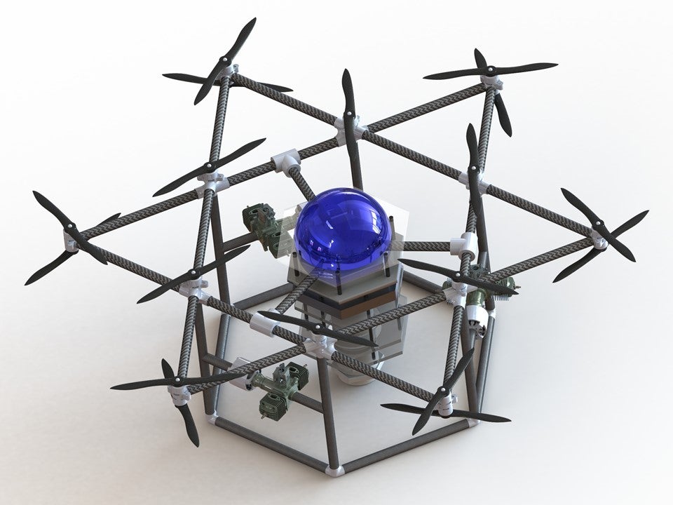
SubUAS (Piscataway, NJ, United
States) – Led by Rutgers professor Javier Diez, the team has created an
AI-enabled drone that can fly quickly to remote survey locations, dive
into the water and use a second set of propellers to navigate and
intelligently explore underwater before flying home for data download,
repowering and return flights.
Tampa Deep-Sea X-plorers
(Tampa, FL, United States) – Led by Edward Larson, the team is using
existing technology and side scanning sonar on multiple AUVs to fully
cover the large mapping area.
Team Tao (Newcastle,
United Kingdom) – Led by Dale Wakeham, the team is developing an
autonomous swarm system for rapid surface to deep ocean exploration.
Texas A&M University Ocean Engineering
(College Station, TX, United States) – Led by Dylan Blakeslee and
working in partnership with successful alumni of Texas A&M; the
University team is using drone ships and AUVs equipped with innovative
navigation systems, renewable power generation and chemical sensing
technologies to explore remote ocean habitats.
Virginia Deep-X-- Virginia Techand Old Dominion University
(Virginia, United States) – Led by Dan Stilwell, the team is developing
small and low-cost underwater vehicles that operate in coordinated
teams.
X994
(Austin, TX, United States) – Led by David Ryan, the team is working to
optimize robotic mapping of the ocean through advancements in software,
AI, and data analytics.
This animation by Rosanna Wan for the Royal Institution tells the
fascinating story of Marie Tharp’s groundbreaking work to help prove Wegener’s theory. Continental drift is common knowledge now, but when the idea was first proposed it was revolutionary. Helen Czerski tells the story of how the maps of one of history’s finest cartographers shifted our view of the planet.
In the early 20th century, Alfred Wegener proposed a revolutionary idea: that the Earth’s continents were once joined together, and had gradually moved apart.
The idea contradicted almost everything scientists thought at the time, and it took the detailed work of a brilliant cartographer to prove him right. Conventional ideas held that the ocean floors were flat, featureless planes.
As expeditions started to go around the world collecting ocean depth measurements, Marie Tharp – not allowed to join the expeditions herself – processed the data and began to craft detailed, revealing maps of the hidden ocean depths. She discovered that the ocean floor was in fact a complex assortment of peaks and troughs.
In particular, her profiles revealed stark rift valleys, which supported Wegener’s controversial ideas.
Even then, it took a long time to convince the scientific community that her findings were correct.
Eventually, however, she was proved right, and Marie Tharp took her rightful place as one of history’s finest cartographers.
Marie Tharp’s incredible maps were integral to the acceptance of the plate-tectonic theory.
She is one of the most underappreciated scientists in the history of the earth sciences.
Though Marie Tharp was a geologist whose work contributed to the ultimate acceptance and success of the plate-tectonic theory, her legacy has garnered little recognition—and most of it has been for her cartographic endeavors.
In my opinion, however, even the admiration she has received for her maps—including the “Atlantic Ocean Floor” map, published in 1968 in National Geographic magazine (included below)—doesn’t rise to the level that those incredible maps deserve.
The animated short above—created by the Royal Institution and selected by National Geographic’s editors for the Short Film Showcase—gives a nice overview of how Tharp’s work advanced the geological sciences by promoting the acceptance of continental drift and seafloor spreading, the key components of plate tectonics.
The Mid-Atlantic
Ridge stands out in glorious detail on this map of the Atlantic Ocean
Floor by Bruce Heezen and Marie Tharp, published as a supplement to the
June 1968 issue of National Geographic Magazine. see "World ocean floor" map
The magnitude of her accomplishment, particularly as a woman in the mid-20th century, working in a field dominated by men, is perhaps best conveyed by Tharp’s own words.
Through mapping the geology of the ocean floor scientists discovered the mid-Atlantic ridge, a feature that suggested that Wegener's unfashionable theory of continental drift might be correct.
These are her thoughts from a biographical piece she wrote upon winning the Woods Hole Oceanographic Institution’s Mary Sears Woman Pioneer in Oceanography Award in 1999:
“Not too many people can say this about their lives: The whole world was spread out before me (or at least, the 70 percent of it covered by oceans). I had a blank canvas to fill with extraordinary possibilities, a fascinating jigsaw puzzle to piece together: mapping the world’s vast hidden seafloor. It was a once-in-a-lifetime—a once-in-the-history-of-the-world—opportunity for anyone, but especially for a woman in the 1940s. The nature of the times, the state of the science, and events large and small, logical and illogical, combined to make it all happen.”
When strong winds prevented filmmaker Jo Ruxton from sending a submarine to her chosen recording location off the coast of Marseille, she was naturally nervous.
The crew had just one chance to document evidence of the build-up of rubbish on the seabed for her award-winning film A Plastic Ocean, but were forced to divert miles from where divers had reported a growing dump.
She needn’t have worried.
As the submersible reached a deep trench one mile from the surface, the team were confronted by a junk yard of human debris.
Tyres, plastic water bottles, synthetic netting, unexploded bombs and even an old parachute emerged from the gloom.
The world’s oceans are drowning in human rubbish.
Each year more than 300 million tons of plastic are produced globally, and 10 per cent will end up in the sea.
It is estimated that there is now a 1:2 ratio of plastic to plankton and, left unchecked, plastic will outweigh fish by 2050.
Not only is the floating haze of scum unsightly, it is also swallowed by marine animals that cannot digest it.
Chemicals leach into the water, and it has been shown that even humans who eat seafood ingest 11,000 pieces of microplastic each year.
Ruxton, who has previously worked as a producer on the BBC’s Blue Planet, said: “People watch wildlife documentaries and think the oceans are still pristine but they aren’t. I’ve known film crews spend two hours clearing up beaches before they can take shots of turtles.”
There are thought to be three million pieces of microplastics in the world's oceans
Credit: Plastic Oceans Foundation
Yet there are signs that the tide may be starting to turn, and Britain could be leading the way.
In 2010, Warwick University announced it had developed a process of recycling all plastic waste.
The technique, called pyrolysis, "cracks" plastic into more basic molecules to form an oil called Plaxx, which can then be used as a fuel, or to make new plastic.
Warwick University spin-off company Recycling Technologies has just opened its first large plant in Swindon, Wiltshire, which operators say will process the plastic of the entire town.
The goal is to roll out similar plants across the world and even install small versions on board dredgers, which can trawl the water, sucking up plastic waste and turning it into fuel to power the ships.
Plastic is notoriously difficult to recycle - and only 12 per cent of household waste is reprocessed. The rest is either burnt or goes to landfill.
The new system aims to turn dumped plastic into a valuable commodity.
“This could really be a game-changing technology,” said Adrian Haworth, of Recycling Technologies.
“There is a worldwide need for it. Only a small amount of plastic is recycled - most ends up in landfill or in the ocean. We need to stop this happening in the first place.
“Eventually we hope to be able to mine landfill sites for plastic, and we’ve had a discussion with a dredging company, with the idea that they would collect the plastic in ports and turn it into fuel on board.”
The US Navy has plasma torches on board to recycle waste
The US Navy and even some cruise ships already operate recycling systems, which take the waste of crew and passengers and heat it to temperatures of more than 5,000C to turn it back into a reusable form.
The plasma torch technology is powerful enough to convert plastics, metals and glass into granules or gas.
The Canadian company behind the system, called PyroGenesis, is planning plasma plants across the world, which could process up to 100 tonnes at a time.
A Dutch entrepreneur is also planning to deploy a pilot device off southern Japan that will, if all goes according to plan, gather and capture some of the millions of tons of plastic that is clogging up the world's oceans.
Some countries, such as Germany, have legislation over plastic.
Since 1991, companies that produce it have been responsible for dealing with their waste, and most supermarkets contain state-of-the art bottle banks that scan bar codes so packaging can be returned to manufacturers.
In 2013, David Katz, a social entrepreneur, founded The Plastic Bank in Lima, Peru, an organisation that pays locals in coastal communities for their plastic bottles, then recycles them, calling the result "social plastic".
Further banks have since been established in Haiti and are due to roll out globally.
The company has released the blueprints for its plastic recycling device so that others can follow suit.
Yet many experts believe that cultural change will have the biggest impact.
Since the 1950s, marketeers have been persuading consumers that plastic is a throwaway product.
One trillion plastic bags are produced globally every year, yet their average working lifespan is just 12 minutes.
“We are in a growing culture of throwaway living,” said Professor Richard Thompson, a global expert on ocean plastics from the University of Plymouth.
“There is an urgent need to recognise that there is no such place as away. Marine debris is damaging to the economy, to wildlife to the environment. It is wasteful and unnecessary, and we all agree that it needs to stop.”
Dredgers are needed to trawl seas collecting waste
Credit: Plastic Oceans Foundation
Ruxton, the producer of A Plastic Ocean, which has been described by Sir David Attenborough as "one of the most important films of our time", said: “It’s crazy how we believe that plastic just disintegrates, and it was because we were told in 1955 that we wouldn’t have to wash up any more.
“But we’re at a tipping point now, and if we don’t act, we won’t be able to go back. In the 1960s we were producing eight million tons of plastic a year. Now it 300 million, and where will we be in another 50 years?
“You go out now and look in the ocean and it is just so prolific. People need to realise that plastic is not disposable. We don’t need all this packaging.”
Musician Jack Johnson has released a 30-minute film called The Smog of the Sea.
It documents a week-long expedition that he and other ‘citizen scientists’ took through the Sargasso Sea of the North Atlantic, to explore the problem of plastic pollution in the ocean.
Guided by ocean researcher Marcus Erikson of 5 Gyres, the participants were stunned to learn that there’s no such thing as a giant floating garbage patch anywhere in the world.
Instead, plastic is everywhere, which is a far worse reality.
A recent study estimated that nine in 10 of the world’s seabirds have pieces of plastic in their guts.
The southern hemisphere, around New Zealand and Australia, is particularly badly affected because of major polluters such as Indonesia and Thailand.
Some albatross and shearwater have been found to have nearly 3,000 pieces of plastic - up to 8 kg - in their stomachs, the equivalent of a human eating 12 pizzas worth of food.
It can’t be digested, so the birds eventually die through lack of nutrition.
In countries such as Tuvalu, where plastic waste washes up by the ton onto shores, locals suspect links with fertility problems.
Professor Susan Jobling of Brunel University discovered that most plastics contain hormone-disrupting chemicals.
Some 92 per cent of adults in Western countries have plastic and chemicals from plastic production in their systems, and their children have twice as much.
"I hope it will make people really think about how they use plastics and make them wonder, for example, if they really need a plastic drinking straw or a single-use plastic bottle,” said Prof Jobling.
A dead puffer fish among human debris
Credit: Plastic Oceans Foundation
There are even worries that what is visible could be just the tip of the iceberg.
About 70 per cent of all ocean debris sinks down from the surface, leading experts to fear that huge rubbish dumps are accumulating unseen at the bottom of the ocean.
Plastic becomes brittle in seawater because it’s subjected to sunlight, waves and salt.
It breaks up into minute pieces and mixes with plankton, so tiny particles of the plastic are sucked up by marine life.
Craig Leeson, director of A Plastic Ocean, said: “Plastic is the most durable material man has ever made, and every piece ever produced is still on the planet in some shape or form.
“If you take plastic water bottles as an obvious example, one of the major problems is that people are using plastic water bottles thinking they are doing themselves a favour, when they are actually damaging their own health.
“The irony of this is that the water in most of these bottles sold to people is not as good as their own tap water.”
Divers are increasingly reporting human rubbish on the bottom of the ocean
Credit: Plastic Oceans Foundation
David Jones, executive adviser on the film, added: “Technology can only do so much. We need to shift people’s perspectives.
“We need to make plastic valuable again. At the moment, the plastic around a water bottle is far more valuable than the water inside it, but people don’t see it like that.
“It’s bizarre that we have to pay someone to take away what is essentially a valuable commodity. Plastic is worth about £400 a ton, but we just throw it away.
“With global warming, we probably have to accept we’re in a predicament and try and mitigate it, but I think with plastic we are still clinging on to the cliff by our fingertips and we still have the chance to pull ourselves back. We have the capacity to do it.” A Plastic Ocean can be downloaded from iTunes and screenings are taking place throughout the country.
Density of finite-size objects after 1.5 years of evolution starting
from a uniform distribution under the combined action of simulated ocean
currents and reanalyzed winds.
A new study on how ocean currents transport floating marine debris is
helping to explain how garbage patches form in the world’s oceans.
Researchers from the University of Miami (UM) Rosenstiel School
of Marine and Atmospheric Science and colleagues developed a
mathematical model that simulates the motion of small spherical objects
floating at the ocean surface.
The researchers feed the model data on currents and winds to simulate
the movement of marine debris. The model’s results were then compared
with data from satellite-tracked surface buoys from the NOAA Global Drifter Program’s
database.
Data from both anchored buoys and those that become
unanchored, or undrogued, over time were used to see how each
accumulated in the five ocean gyres over a roughly 20-year timeframe.
“We found that undrogued drifters accumulate in the centers of the
gyres precisely where plastic debris accumulate to form the great
garbage patches,” said Francisco Beron-Vera, a research associate professor in the UM Rosenstiel School’s Department of Atmospheric Sciences
and lead author of the study.
“While anchored drifters, which are
designed to closely follow water motion, take a much longer time to
accumulate in the center of the gyres.”
Global plastic concentration map based on data collected during the Malaspina 2010
circumnavigation and regional surveys.
Credit: Cozar, A., et al. (2014), Plastic debris in the open ocean, Proc. Nat. Acad. Sci. USA,
The study, which takes into account the combined effects of water and
wind-induced drag on these objects, found that the accumulation of
marine debris in the subtropical gyres is too fast to be due solely to
the effect of trade winds that converge in these regions.
“We show that the size and weight of the drifters must be taken into account to fully explain the accumulation,” said Maria Josefina Olascoaga, an associate professor in the UM Rosenstiel School’s Department of Ocean Sciences and a co-author of the study.
The model could be used to track shipwrecks, airplane debris, sea ice
and pollution among the many practical applications according to the
researchers.
The study, titled “Inertia-induced accumulation of flotsam in the subtropical gyres,” was published in Geophysical Research Letters.
The study’s authors are: Francisco Beron-Vera, Maria Josefina
Olascoaga, and Rick Lumpkin from the NOAA Atlantic Oceanic and
Meteorological Laboratory (AOML).
The interactive timeline
will be very useful during this activity and you can also download a
smaller ‘Britain and the Sea 1650-1850 timeline’ from the bottom of this
page.
They also laid the foundations of vast
European empires that lasted into the 20th century and had profound
effects in shaping the world we inhabit today.
The history of European empires is a maritime one –
one powered for hundreds of years by ships and sailors and by wind and
sail.
This ‘Age of Sail’ (c.1600-1850) was a period of significant and
rapid change in the scale, technologies, social world, politics and
public importance of seafaring.
It was also the period when many of the
political and legal institutions, scientific ideas, economic structures,
and even geographic boundaries of the modern world developed.
There are hundreds of stories we could draw out
from this period, but within this activity we will be looking
specifically at Britain’s expanding maritime world in the Age of Sail.
The rest of the articles in ‘The Age of Sail and Global Seafaring’
provide examples from Britain’s maritime empire to draw out important
stories, archaeological finds and developments in seafaring.
But first,
here is a short overview of this important period.
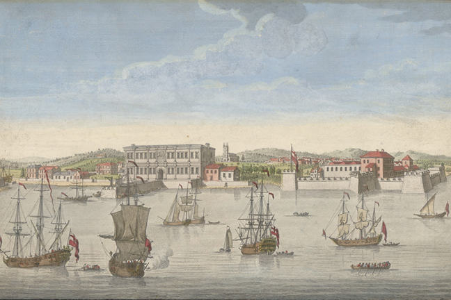
'Bombay on the Malabar
Coast belonging to the East India Company of England'. Engraving by Jan
Van Ryne, published Robert Sayer, London, 1754.
The period between about 1600 and 1850 saw the
development of the collection of overseas colonies, trading posts and
military strongholds that came to be known as the British empire.
English colonial interests were first focused across the Atlantic, on
the colonies in the Caribbean and eastern seaboard of North America.
By
the eighteenth century, in common with a number of European countries,
Britain drew significant wealth from the sugar plantations of her
Atlantic colonies.
These were worked by enslaved people trafficked
across the Atlantic in European ships, via the slave trade.
Goods, people and ideas all travelled along sea routes protected by the
Royal Navy (from pirates as well as other European vessels),
contributing to the economic and cultural interchanges that defined this
British Atlantic world.
The Smithsonian has a very good online exhibition on the Atlantic World.
The Indian Ocean, the Pacific and Britain’s Empire in the East
From the early seventeenth century the East India
Company, a speculative merchant joint-stock company, had traded valuable
goods like porcelain, silk, indigo dye, salt and tea from Asia to the
British Isles.
The Company initially established coastal trading posts
in India through negotiation with local rulers.
‘India ships’ sailed
annually from the British Isles utilising the Indian Ocean’s monsoon
winds to reach the often-precarious outposts.
In the eighteenth century,
as they grew and became increasingly embroiled in conflicts with local
rulers and competing European powers, the British involvement in India
came to be shaped as much by the control of territory as by trade.
In the late eighteenth century, while the British
expanded their control over India, the American War of Independence led
to the loss of Britain’s North American colonies and parliament
discussed abolition of the slave trade.
The geographic focus (as well as
the ‘purpose’) of Empire began to shift.
And as the eighteenth
progressed into the nineteenth century, Britain expanded her interests
in the East in new ways.
James Cook
made voyages of ‘scientific discovery’ to the Pacific to pursue
astronomical measurements in Tahiti, but also to further explore the
Ocean.
Following his ‘discovery’ of Australia, the ‘First Fleet’ was
dispatched to establish a penal colony, which led in turn to settler
colonialism in Australia and latterly New Zealand.
Cartoon map showing monarchical France in the form of a sailing ship at sea. Relief shown pictorially.
- Also shows administrative divisions (departments). Text, calendar, and map names in English. Index of departments in French. Title from first sentence of text at lower left.
- "Published as the act directs, June 28th 1796, by the author, no. 49 Great Portland Street." Paris meridian. Watermark: 1794 J. Whatman. Available through the Library of Congress Web
Three Ocean Worlds
It is important to recognise that the ocean worlds
of the Atlantic, Indian Ocean and Pacific that Europeans entered over
this period were very different.
The geographies, weather systems, ocean
currents and, most importantly, histories of each ‘ocean world’ were
unique.
Though there was indigenous seafaring along and around the
coasts and islands of the Atlantic, for example, there was no large
transoceanic seafaring tradition.
In contrast, when Europeans first
sailed around the Cape into the Indian Ocean they entered a complex,
maritime world with a long history and established transoceanic trade
routes, communities and technologies.
The mechanisms and impacts of European exploration, trade and colonisation were, therefore, particular to each ocean world.
Maritime Archaeological Worlds
Finally, it is also important to remember the
larger historical narratives of Britain’s maritime empire often focus on
the lives of rich, European men.
Maritime archaeology can certainly
provide important insights into the ‘big’ events and stories (both the
celebrated and the infamous) of Britain’s Imperial past.
But it can also
offer us glimpses into the everyday lives of sailors, migrants,
convicts, indentured labourers and even slaves.
Shipwrecks and port
archaeology present a window onto a world in motion – where all types of
people and their possessions, goods and raw materials, and even ideas
were on the move.
That means that if we explore this archaeology
carefully, and ask the right research questions, we have the chance to
better understand the lives of all types of people from all over the
Empire, and thereby better understand our own world.