Two mating sea angels flutter through the deep waters of the Arctic Ocean off the coast of Novaya Zemlya, an archipelago near northern Russia, in recently captured footage.
In the video, which was filmed by marine biologist Alexander Semenov, a single clearly visible sea angel is joined by a second one.
The pair of sea slugs then swims through the water side-by-side in a flowing mating ritual that resembles a dance.
When two sea angels find each other, they turn out their reproductive organs and attach themselves to their partner’s body with a sucker to stay together during the mating process.
This attachment leaves scars on their bodies, and some adult sea angels have up to four scars, which can indicate frequent mating rituals.
The fertilization process can last up to four hours, and while it happens, the sea angels stay connected to each other, swimming gracefully through the water with the help of all four of their wings.
Semenov says their mating ritual doesn’t affect their appetite, and sea angels can hunt for prey while they are attached to each other.
Once the mating ritual is complete, the sea angels move in a spiral shape in order to disconnect.
“This miniature creature is an incredibly graceful swimmer; watching it is a complete pleasure,” says Semenov. "They seem to float in the air, slowly waving their wings.”
Sea angels, so named because their shape resembles a snow angel, have translucent white bodies that are long, with a wing-like structure on both sides of their bodies.
Because they are semi-transparent, it is easy to see the coral-pink and yellow coloring of their internal structures.
Sea angels’ lovely outward appearance and name belie their status as a kind of sea slug, related to other forms of snails in the gastropod class.
They inhabit the frigid waters of the Arctic, subarctic Atlantic, and Pacific oceans, and prey on sea butterflies—specifically a small type of sea snail called Limacina helicina.
Some sea snails have even developed small tentacles with which they can catch their prey and hold it while they eat.
Scientifically named Clione limacina, they are protandrous hermaphrodites, which means they are both male and female during their life cycles, according to Semenov.
Young sea angels start out as males, developing eggs as they grow into adults.
Mature sea angels have both eggs and spermatozoa in their bodies.
“Ithink that for some people,” says Peter Girguis, a deep-sea microbial physiologist at Harvard University, “the ocean seems passé — that the days of Jacques Cousteau are behind us.”
He begs to differ.
Even though space exploration, he says, “seems like the ultimate adventure, every time we do a deep sea dive and discover something new and exciting, there’s this huge flurry of activity and interest on social media.”
But the buzz soon fizzles out, perhaps because of ineffective media campaigns, he says.
But “we’re also not doing a good job of explaining how important and frankly exciting ocean exploration is.”
That might change with the launch, this month, of the Ocean Observatories Initiative, an unprecedented network of oceanographic instruments in seven sites around the world.
Each site features a suite of technologies at the surface, in the water column, and on the seafloor.
Buoys, underwater cameras, autonomous vehicles, and hundreds of sensors per site will collect data on ocean temperature, salinity, chlorophyll levels, volcanic activity, and much more.
Using this set of systems, oceanographers hope to address the limitations imposed by working on a ship or a single site for a limited period of time.
OCEAN EXPLORER: Peter Girguis thinks there is still much to be learned in the deep sea.
Photo: Rose Lincoln/Harvard News Office
“What that means is, in general, we’re very good at doing one of two things: studying the ocean spatially, such as studying the same process as you cross an ocean, or temporally, studying one point over time,” says Girguis, “But going back to about 20 years ago, scientists began to say, maybe there’s a way to do both of these better.”
Getting the Initiative off the ground (or, rather, in the water) has taken 10 years and $386 million, and the launch is only the beginning: Operational costs will comprise about a sixth of the National Science Foundation’s annual ocean sciences budget, and the ocean’s tendency to rust metals and fry wiring could lead to higher maintenance costs over time.
With data now flowing, the questions that have followed the Initiative’s development are once again bobbing to the surface: Will it work? Will it be useful? And will the millions of dollars that taxpayers have provided be worth their investment?
We sat down with Girguis to talk about the worth of the Ocean Observatories Initiative and its place in modern marine science.
Why haven’t there been many large-scale commitments to ocean science, like this initiative, in recent years?
When they landed a spacecraft on the moon, all they had to do to keep the astronauts at one atmosphere was design a spacecraft that could tolerate one atmosphere of pressure.
Outside of the ship it’s simply zero atmospheres — that’s a difference of one.
When we dive in the submersible Alvin, routinely, to go to our study sights, Alvin has to withstand 250–300 atmospheres.
And the ocean is a harsh environment.
Alvin has to battle corrosion, electrical shorts; we have to keep from getting stuck on deep sea corals; and around vents, we have to keep from having the plastic windows — which, yes, they are plastic — from melting in water coming out that’s 300 degrees Celsius.
The fact that this seems routine to us scientists is a tribute to the engineers that make it happen.
But the fact that the public thinks it is routine means we scientists should be doing a better job of explaining the adventure of it, and also the deep and profound importance that our ocean has in keeping our planet healthy.
Does having the Ocean Observatories Initiative arrays in only seven places limit what they can tell us about the ocean?
This project is by no means comprehensive.
I don’t think anybody would say we are comprehensively studying the ocean.
That does not mean that it is meaningless.
We have, as a community, tried to judiciously pick sites that could tell us something about the other areas of the ocean.
Think of them as good representatives of wider-spread environments.
Additionally, those arrays are, to a degree, moveable assets.
They are essentially giant moorings, which in some point in the future could be picked up and moved to another locale.
But these seven sites are chosen because they’re good representations of important regions of the ocean — not only for natural scientists but also for applied scientists, like those trying to understand fisheries and fish stocks, and how the ocean responds to humans.
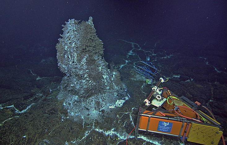
SECRETS OF THE DEEP: A deep-sea Ocean Observatories Initiative camera trained on a sea floor chimney located 5,000 feet down off the coast of Oregon.
Photo: NSF-OOI/UW/CSSF; Dive R1730; V14
How can researchers use the Initiative’s data in their work?
One example: By co-localizing these sensors, researchers can help monitor when phytoplankton — which make, by the way, half the oxygen you breathe — bloom, and grow to huge numbers.
When they do that, it’s not always clear what causes it.
By having sensors and samplers co-located, you can start to make correlations that help you identify a cause.
And I chose that phrase carefully: Correlations are easy to come by, but it’s only when you have a really good data set that you can really move from a correlation to a cause. How will the array aid in your research?
I work primarily in the deep sea, at the hydrothermal vents in the Northeastern Pacific off the coast of Oregon, Washington, and Vancouver.
By deep sea, I mean the part of the ocean that is perpetually dark, which is 80 percent of our planet’s habitable space.
What happens in the deep sea is very much influenced by what happens in the surface waters, because that’s where most of the food in the deep sea comes from.
Conversely, we now finally have the data to support some long-standing questions and ideas we had about how processes in the deep sea influence what happens on the surface.
Hydrothermal vents, for example, are a major ocean source of iron and trace minerals.
They’re kind of like the ocean’s multivitamin.
You don’t need a lot of this stuff, in the same way were not guzzling pounds of iron, but you need just enough to stay healthy.
And that’s what hydrothermal vents provide.
By studying the processes on the surface, and concurrently studying processes in the deep sea, we can start understanding the ocean as a system, and not as a bunch of compartmentalized ecosystems.
I’m excited about using the observatories to look at the linkages among all of these processes — biological, chemical, and physical.
Are you concerned that the high price of the project will lead to fewer exploratory projects?
That is a really big question now.
I think scientists owe it to the taxpayers to make best use of these assets, and best use of the money, and to provide an explanation for the value of our work.
But the Ocean Observatories Initiative has the potential to bring together different federal and non-government agencies to look at the relationships that we have not previously considered.
So, a hypothetical example — as the ocean’s multivitamin, hydrothermal vents could stimulate phytoplankton in the Northeast Pacific.
How does that influence commercial fisheries, like salmon or tuna?
That’s a question nobody really knows the answer to.
And it could bring interest from agencies outside of the National Science Foundation, like the National Oceanic and Atmospheric Administration, the U.S. Geologic Survey, the Environmental Protection Agency, even commercial fisheries.
Expand it even further — Google is always interested in providing real-time information on traffic.
It’s not unreasonable that commercial entities could make use of some of these systems, to provide information for commercial operations.
The question should not be limited to what we can do with our current sensors, but rather:
What is it that we’re not doing yet that would change the way we think about our oceans?
And, how do we develop the tools and methods to change that?
So it’s my hope that the observatories expand well beyond the scope of the National Science Foundation, and well beyond their sole dependence for support.
Satellite data helped scientists locate the volcanic source of a pumice raft floating in the South Pacific Ocean, illustrating their promise in locating and monitoring undersea eruptions.
In August 2019, news media reported a new pumice raft floating in the territorial waters of the South Pacific island kingdom of Tonga.
This visible evidence of an underwater volcanic eruption was borne out by seismic measurements, but conditions were less than ideal for using seismic sensors to precisely locate the source of the eruption.
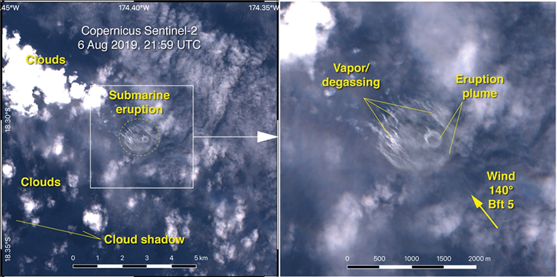
My colleagues and I eventually traced the source of the pumice raft to a submarine volcano referred to as “Volcano F” using a combination of satellite and seismic data (Figure 1), demonstrating remote sensing’s potential for locating and monitoring underwater volcanoes [Brandl et al., 2020].
Fig. 1 The drift of the pumice raft between 8 and 14 August 2019 following the 6–8 August eruption at Volcano F.
Dots represent locations of pumice on the sea surface and other observations reported by the ROAM catamaran.
Volcanoes that breach the sea surface often provide clues to impending eruptions, and the events during and after eruptions demonstrate the hazards that marine volcanoes can pose to communities nearby.
For example, after several months of growth, a large sector of the south flank of Anak Krakatau, a volcanic island situated in the Sunda Strait of Indonesia, suddenly collapsed into the sea on 22 December 2018.
The resulting tsunami killed more than 430 people in nearby coastal areas of Java and Sumatra; it also injured 14,000 people and displaced 33,000.
This cascade of events was not totally unexpected because the part of the island above water was clearly visible and was being monitored [Walter et al., 2019].
Unlike events above the sea surface, landslides, earthquakes, volcanic eruptions, and other geological events below sea level are seldom observed as they are happening, but they can also wreak havoc on vulnerable coastal communities.
Despite the hazards they pose, assessing the natural hazard risk and mitigating the aftereffects of submarine events remain major challenges.
In many cases, the events themselves are hidden beneath the water, and only their direct aftermaths are visible.
Recent advances, especially in remote sensing techniques, may enable scientists to identify potential underwater hazards and areas at risk in the near future.
The Challenge of Underwater Eruptions
Landslides and earthquakes are particularly hazardous when they occur not as isolated events but as parts of cascading natural disasters.
When these events occur underwater, the disaster might not be evident until it is well under way.
Landslides can be directly located only if they are associated with seismicity or are not exclusively submarine.
And although global seismic networks can precisely locate earthquakes, determining the details of fault motion, which can influence whether quakes trigger subsequent hazards like tsunamis, requires knowledge of the local seafloor geology and tectonic structure.
Mapping the seafloor for potential hazards will remain challenging because water rapidly absorbs the electromagnetic waves used in satellite remote sensing methods used to map land surfaces.
In most cases, submarine volcanic activity thus stays obscured from our eyes.
This is especially true if an eruption is effusive rather than explosive or if an eruption does not breach the sea surface to produce a detectable volcanic gas plume in the atmosphere.
Visible eruptions from submerged volcanoes are the exceptions.These include silicic eruptions at island arcs, which are often explosive and eventually eject matter into the air.
They also include eruptions of pumice, a highly porous, low-density abrasive volcanic rock that can float on the sea surface [Carey et al., 2018].
Large volumes of pumice can aggregate into rafts that drift with the wind, waves, and currents and that present hazards for ships.
But these rafts also provide clues to recent submarine eruptions.
Scientists currently rely on in situ methods to track floating pumice rafts, but improved Earth observation from space, coupled with automated image analysis and artificial intelligence, could further enable tracking, ultimately allowing us to trace them back to their volcanic sources if weather permits.
Sourcing the Tonga Pumice Raft
During the August 2019 eruption that produced the pumice raft near Tonga, two stations of the global seismic network located far out in the Pacific Ocean on the islands of Niue and Rarotonga recorded T phases, low-frequency sound waves related to submarine volcanic eruptions.
Under ideal conditions, such seismoacoustic signals can be transmitted over very long distances because they couple into a specific layer of the ocean water column, the sound fixing and ranging (SOFAR) channel, which acts as a guide for sound waves.
Sound waves reach their minimum speed within the SOFAR channel, and these low-frequency sound waves may travel thousands of kilometers before dissipating.
T phases from the 2011 submarine eruption of the Monowai volcanic system, for example, were transmitted in the SOFAR channel over more than 15,000 kilometers.
However, under less favorable conditions, seismoacoustic signal transmission may be more limited.
The Tonga Ridge is one example of where such unfavorable conditions prevail because the ridge sits in shallow water and breaches the surface in some places, thus blocking seismoacoustic signal transmissions in some directions.
During the August 2019 eruption, it was not possible to use triangulation to define the precise location of the source because only two stations recorded the relevant T phases.
This difficulty clearly emphasizes the need for increased sensitivity of the global seismic network in this part of the world, which is particularly important with respect to submarine natural hazards.
Seismoacoustic signals may be directly linked to an active submarine eruption, but seismic precursor events may also hint at increasing activity within a volcanic system.
In the case of the 6–8 August eruption of Volcano F, eight earthquakes of magnitude 3.9–4.7 were detected in the vicinity of the volcano in the days and hours prior to the eruption.
However, given the tremendous amount of seismic activity in this area and the related mass of data under normal conditions, events of this scale usually trigger interest only when followed by a larger and more significant geohazard.
Thus, submarine volcanic eruptions may go unnoticed unless boats and ships report encountering pumice rafts or surveillance flights report visual observations of eruption plumes.
In this respect, recent advances in the quality, quantity (e.g., daily coverage), and availability (e.g., the open-source data of the European Union’s Copernicus program) of satellite observations have greatly improved our ability to visually detect ongoing volcanic eruptions and their immediate aftermaths, thus representing an important addition to monitoring capabilities.
Satellite data may include, among other things, visual observation of the sea surface and spectral detection of volcanic gases or temperature variations in the atmosphere.
This satellite imagery shows the sea surface on 6 August 2019 following the eruption of Volcano F.
Abbreviations are UTC, coordinated universal time; Bft 5, Beaufort scale category 5 winds, corresponding to 29–38 kilometers per hour.
Credit: European Space Agency, Copernicus Sentinel-2, modified by Philipp Brandl
The European Space Agency’s (ESA) Sentinel-2 satellite, for example, captured a plume of discolored convecting water, volcanic gas, and vapor about 1.2 kilometers wide coming from the shallow submarine eruption of Volcano F.
By combining data from Sentinel-2, available through Copernicus, and from NASA’s Moderate Resolution Imaging Spectroradiometer (MODIS) system, we tracked the daily dispersal and drift of the related pumice raft.
Gathering Data from Many Sources
Because these satellite techniques are restricted to studying the sea surface, we may still miss many volcanic eruptions in the deep sea.
Only hydroacoustic techniques deployed from ships or autonomous underwater vehicles (AUVs) are capable of surveying the ocean floor at needed resolutions, so increased marine research focused on rapid response to submarine eruptions and landslides could strengthen our ability to predict potential natural hazards in the deep sea.
Ship-based multibeam mapping (which can achieve resolutions down to about 15 meters) of submarine volcanoes can help constrain eruption dynamics and volume and monitor morphological changes of volcanic edifices during or after an eruption.
And developments in robotic technology for seafloor mapping, such as unmanned surface vehicles and improved AUVs, which could extend resolution to less than 1 meter, may soon lead to significant advancements in our marine remote sensing capabilities.
But currently, the limited coverage of these techniques—less than about 30% of the ocean floor has been mapped by ship-based multibeam sonar—means that only a few areas exist where repeated multibeam surveys allow us to analyze changes in bathymetry over time.
Several segments of the East Pacific Rise, of the Galápagos Spreading Center, and of the Juan de Fuca Rise are examples of areas where detailed bathymetric maps have been used to monitor volcanic activity.
In the southwestern Pacific, well-mapped areas include arc volcanoes such as those in the Tofua-Kermadec Arc, the Monowai Volcanic Center, the Havre and Brothers volcanoes, and West Mata.
Repeated phases of growth and partial collapse of the edifice of the Monowai arc volcano have been well monitored [Watts et al., 2012].
However, this level of monitoring has been possible only through repeated bathymetric surveys (1978, 1986, 1998, 2004, 2007, and 2011) that together integrate to an important time series.
During a cruise in 2018, my colleagues and I “accidentally” mapped the flanks of Volcano F (it was not the focus of our cruise).
By combining our data with preexisting data from an Australian cruise, we created a combined bathymetric map (Figure 2) that could serve as a basis for future changes in bathymetry due to volcanic activity [Brandl et al., 2020].
Fig. 2. Composite bathymetry of Volcano F from ship-based multibeam data collected by R/V Sonne cruise SO267 and R/V Southern Surveyor cruise SS2004/11.
At present, the risk potential of cascading events in the submarine realm is poorly understood, mainly because of the lack of data and monitoring.
Studies like those described above would be of great value in assessing the risks of cascading natural disasters elsewhere—for example, at the many arc volcanoes whose edifices are composed of poorly consolidated volcaniclastic material rather than of solid masses of rock.
Volcanic growth can lead to a buildup of material that if followed by partial sector collapse, can trigger a tsunami—this was the case at Anak Krakatau in 2018.
Emerging technologies such as artificial intelligence and machine learning could fill an important gap.
Proactive automated processing of data from global seismic networks could help to identify clusters of increased seismicity that could be precursors to volcanic eruptions.
The locations and timing of these clusters could then be used to pick out features in hydrophone data from the same times and places that correlate with submarine eruptions.
Earth and computer scientists are currently developing techniques for automated image analysis and data processing as well as the use of artificial intelligence for pattern recognition and the proper identification of submarine volcanic eruptions.
Moving Beyond Accidental Discovery
Currently, submarine eruptions from island arc volcanoes and mid-ocean ridges are observed mainly by accident or when their eruption products breach the sea surface.
Thus, we likely never see a significant proportion of submarine volcanic eruptions.
And we lack the ability to monitor submarine volcanic activity on a global scale, which limits our ability to assess risks related to underwater volcanic eruptions, sector collapses, and cascading events.
Remote sensing techniques that collect data from space and at sea may provide us with more powerful tools to detect and monitor this volcanic activity and to project associated risks in remote areas.
Recent advances in data processing may also greatly improve capabilities in this field.
And compiling existing data and collecting new data related to submarine volcanic activity in a dedicated open-access database should help researchers estimate risk potentials as the first step toward forecasting natural hazards.
The experience with the 2019 eruption of Volcano F shows how important the integration of open-source and interdisciplinary remote sensing data is for the monitoring and management of natural hazards.
An Indonesian fishing boat heads out to sea in domestic waters, where they have seen their catches dwindle since Chinese fishing boats have been fishing closer to Indonesian water, near Natuna, Indonesia, in January. Photographs by Adam Dean
From NYTimes by Hannah Beech and Muktita Suhartono The Indonesian government appears to have backed away from confronting China, its largest partner. "Our fishermen feel scared,", one official said
Dedi knows where the fish run strongest in Indonesian waters off the Natuna islands.
The Chinese know, too.
Backed by armed Chinese Coast Guard ships, Chinese fishing fleets have been raiding the rich waters of the South China Sea that are internationally recognized as exclusively Indonesia’s to fish.
While Mr. Dedi catches the traditional way, with nets and lines, the steel Chinese trawlers scrape the bottom of the sea, destroying other marine life.
So not only does the Chinese trawling breach maritime borders, it also leaves a lifeless seascape in its wake.
“They come into our waters and kill everything,” said Mr. Dedi, who like many Indonesians goes by a single name. “I don’t understand why our government doesn’t protect us.”
Wary of offending Indonesia’s largest trading partner, Indonesian officials have played down incursions by Chinese fishing boats, trying to avoid conflict with Beijing over China’s sprawling claims in these waters.
But with the Chinese presence growing more aggressive, fishers in the Natunas are feeling vulnerable.
“There was a vacant period, then China came back,” said Ngesti Yuni Suprapti, the deputy regent of the Natuna archipelago.
“Our fishermen feel scared.”
The latest episode occurred in February, fishers said, when Chinese fishing boats flanked by Chinese Coast Guard vessels dropped their trawl nets yet again.
It seemed as if the coronavirus outbreak peaking in China at the time hadn’t diminished the country’s global ambitions.
A crew heading out to sea.
The Indonesian fisheries ministry, however, denied any intrusion by the Chinese.
The Indonesian government does not provide data on incursions by foreign fishing boats.
China’s illegal fishing near the Natunas carries global consequence, reminding regional governments of Beijing’s expanding claims to a waterway through which one-third of the world’s maritime trade flows.
But local leaders in the Natunas don’t control what happens near their shores.
“We only have authority over our land,” said Andes Putra, the head of the Natunas’ Parliament.
“The provincial and central governments handle the seas.”
Yet with multiple agencies responsible for protecting the seas — the navy, the coast guard, the marine police and the fisheries ministry, to name a few — decision-making is diffuse, analysts said.
“There is a lack of a single coherent lead agency or a single coherent policy for maritime security,” said Evan Laksmana, a senior researcher at the Center for Strategic and International Studies in Jakarta, the Indonesian capital.
“The Chinese can take advantage of that.”
Idil Basri, the captain of a Natuna fishing boat.
Chinese impunity was on full display in January when President Joko Widodo of Indonesia visited the Natunas.
“There is no bargaining when it comes to our sovereignty,” Mr. Joko said.
Earlier, Indonesian fighter jets buzzed the sky, while warships patrolled the seas.
But the day after Mr. Joko left the Natunas, the Chinese showed up again.
Its fishing fleet, backed by the Chinese Coast Guard, took days to leave the area, local officials and fishers said.
The fisheries ministry denied that any such incident had taken place.
On Chinese maps, a line made of nine dashes scoops out most of the South China Sea as China’s.
One of the dashes slices through waters north of the Natunas.
by The NYTimes
While Beijing recognizes Indonesian sovereignty over the Natunas themselves, the Chinese Foreign Ministry describes the nearby sea as China’s “traditional fishing grounds.”
“Whether the Indonesian side accepts it or not, nothing will change the objective fact that China has rights and interests over the relevant waters,” Geng Shuang, a Chinese Foreign Ministry spokesman, said in January.
In 2016, an international tribunal dismissed the nine-dash line as legally baseless.
The Chinese government ignored the ruling.
Instead, Beijing continued turning contested atolls and islets into military bases from which China can project its power across the South China Sea.
“Little by little, I think the Chinese will take the Indonesian sea, the Philippine Sea, the Vietnamese sea,” said Wandarman, a fisherman in the Natunas.
“They are hungry: oil, natural gas and lots and lots of fish.”
The Chinese fishers are helping feed the country’s growing appetite for seafood by trawling the South China Sea.
But they are also serving a broader purpose.
“Beijing wants Chinese fishers to operate here,” said Ryan Martinson, an assistant professor at the China Maritime Studies Institute at the United States Naval War College, “because their presence helps to embody China’s maritime claims.”
During Mr. Joko’s first term, his fisheries minister, Susi Pudjiastuti, stood up to China and other countries illegally operating in Indonesian waters.
A fish market in Natuna.
The navy fired warning shots at Chinese fishing boats.
Ms. Susi ordered the seizure of foreign boats.
She had dozens blown up.
One, a Vietnamese trawler, still slumps half submerged in a Natuna harbor.
As a result of Ms. Susi’s boat-sinking policy, the Chinese boats stopped intruding in large numbers, fishers in the Natunas said.
“She protected us, and she protected Indonesia,” said Idil Basri, the captain of a Natuna fishing boat.
But Ms. Susi’s stance, while popular with the public, irked others in government, who found her too confrontational, political analysts said.
When Mr. Joko chose his ministers for his second term last October, Ms. Susi, a fishing magnate, was gone, replaced by a minister considered more conciliatory to China.
In the Natunas, the change was almost immediate, fishers said.
“The Chinese boats came back,” Mr. Dedi said.
In late October, one day after Mr. Joko’s new cabinet was installed, Mr. Dedi’s boat was well within the 200-nautical-mile exclusive economic zone in which only Indonesians are permitted by international law to fish.
A Chinese Coast Guard vessel appeared, then another.
Mr. Dedi scrambled to record video of his boat’s coordinates, 72 nautical miles north of the Natunas.
While it is not illegal for foreign military vessels to transit through these waters, the coast guard ships were protecting Chinese trawlers.
A fisherman rides his scooter down a fishing dock.
After handing over his video to local maritime authorities, Mr. Dedi waited for action.
Nothing happened, so he posted it on Facebook.
Indonesian security services called him, he said, and sounded vaguely threatening.
Mr. Dedi continued to have run-ins with Chinese boats through February.
In one case, he was in a standoff with the Chinese for an hour before he turned around for lack of Indonesian backup.
“We left, but they were still there in Indonesian waters,” Mr. Dedi said.
A Vietnamese fishing boat caught fishing in Indonesian waters is seen sunk off the coast of Natuna.
China’s buildup on disputed outposts in the South China Sea has boosted the ability of its coast guard to ply the waters near the Natunas.
During storms, Chinese fishing boats can shelter at these artificial islands, too.
In 2016, as Indonesian authorities tried to tow in a Chinese boat operating off the Natunas, a Chinese Coast Guard ship nosed in and broke the towline, allowing the Chinese fishers to flee.
To counter China’s presence, Indonesia began building a military base in the Natunas four years ago.
Today, the facility is moldering, empty of all but a few soldiers.
Jakarta’s latest tactic is to relocate hundreds of fishers from the populous Indonesian island of Java to the Natunas to act as maritime sentries.
But fishers in the Natunas oppose the idea, since the Javanese are subsidized by the state and do the same destructive bottom trawling as the Chinese.
Mr. Wandarman said that because of the profusion of foreign boats in recent months, his catch had declined by half.
But fishing is his livelihood, Mr. Wandarman said.
The island he lives on has only two traffic lights, and not much to support it economically besides the sea.
“Our boats are small and wooden, and the Chinese Coast Guard is armed and modern,” Mr. Wandarman said.
“My fear out there is bigger than the sea is big.”
The crew of an Indonesian fishing boat heads out to sea.
There has been a lot of discussion about autonomous vehicles on the land and in the air, but what about on the sea?
While the world got the first glimpse of a fully autonomous ferry thanks to the collaboration between Rolls-Royce and Finferries, the state-owned ferry operator of Finland, there’s still quite a bit of work to be done before we can expect the world’s waterways to be overtaken with autonomous vessels.
Levels of Autonomy
Even though we might be years or even decades away from the majority of vessels becoming autonomous, there are certainly artificial intelligence algorithms at work today.
A fully autonomous ship would be considered a vessel that can operate on its own without a crew.
Remote ships are those that are operated by a human from shore, and an automated ship runs software that manages its movements.
As the technology matures, more types of ships will likely transition from being manned to having some autonomous capabilities.
Autonomous ships might be used for some applications, but it's quite possible that there will still be crew onboard some ships even if all hurdles to acquiring a fully autonomous fleet are crossed.
Autonomy in Ships
As we saw with the Finnish ferry, the first autonomous ships will be deployed on simple inland or coastal liner applications where waters are calm, the route is simple, and there isn't much traffic.
There’s also an inland electric container ship, Yara Birkeland, under construction that is expected to be completed in 2020 and fully autonomous by 2022.
Some companies are building fully autonomous ships from scratch, while other start-ups are developing semi-autonomous systems to be used on existing vessels.
When Rolls-Royce sold its autonomous maritime division to Kongsberg, it gave the Norwegian company a boost in its goal of being a leader in the autonomous shipping industry.
Samsung is another company that uses machine learning, augmented reality, analytics, and more to create a smart shipping platform through its Samsung Heavy Industries division.
Existing cargo ships have the chance to get retrofitted with autonomous technologies thanks to the efforts of start-ups such as San Francisco-based Shone.
Shone’s technology helps crews with piloting assistance and to detect and predict the movement of other vessels in the waterway.
Benefits of Autonomous Ships
Just as artificial intelligence and autonomy promise in other applications, it is expected that autonomous ships can improve safety, increase efficiency, and relieve humans from unsafe and repetitive tasks.
According to a study by Allianz, between 75% and 96% of maritime accidents are caused by human error.
If autonomous and semi-autonomous systems can help reduce the reliance on humans that can make mistakes due to fatigue or bad judgment, autonomous ships could eventually make our oceans safer.
Even if a crew is on board, the data gathered from the ship’s sensors combined with artificial intelligence algorithms will help the crew make better-informed decisions.
Since there are significant safety concerns especially with the enormous size of most ships operating in congested waters, there is a lot more testing to be done and regulations to be sorted out before we will see fully autonomous vessels operating without a crew.
Much more likely is that automated technologies will be used to reduce crews and to help the crew onboard make effective decisions.
In addition to ensuring the safety of ships, there needs to be a resolution about the regulation of our shared water. Existing international conventions were created under the assumption a crew would be on board.
In response, the International Maritime Organization (IMO) has kicked off its work to assess and update conventions to ensure safety in a new reality when AI is the captain instead of humans.
Until there is significant interest in fast-tracking research, development, and updates to regulations for autonomous ships, the industry will likely learn from the decisions made on land regarding autonomous cars and then apply that to autonomous ships.
Adoption and acceptance of autonomous cars in the coming years may put pressure on finding the same solutions for the sea.
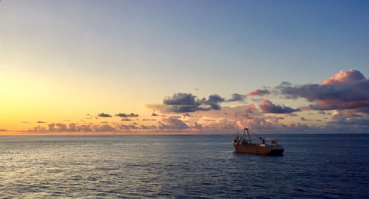
The abandoned 'Ghost Ship' MV ALTA washed up on the Irish coast during Storm Dennis.
Alta was abandoned in October 2018 after a US Coast Guard relief operation to rescue the crew about 2,200 km (1,400 miles) south-east of Bermuda, stranded after the ship was rendered irreparably disabled on a voyage from Greece to Haiti.
The ghost ship was then sighted by HMS Protector en route to the Bahamas.
In February 2020 the ghost ship Alta ran aground on the coast near Ballycotton, County Cork amid Storm Dennis.
This footage was filmed on Tuesday 18th February 2020. Video by Youghalonline
The MV Alta drifted in the Atlantic ocean for 18 months, before crashing into the coast of Ireland. Tracking and current data gives us intriguing clues about its final, fateful voyage
Storm Dennis swept in from the Atlantic, its high winds and heavy rains driven by a powerful jet stream.
The extreme weather, which battered the UK and Ireland in February, flooded of thousands of homes and caused widespread travel disruption and several deaths.
In Ireland, it created a mystery.
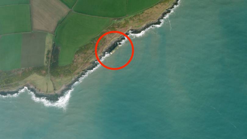
At some point in the early hours of February 16, a ship washed up on the rocks off the village of Ballycotton in County Cork.
First spotted by a jogger out for their Sunday lunchtime run, the ship was soon making global headlines.
photo : Irish Coast Guard
In its final resting place, the MV Alta was perched sideways on top of a series of jagged rocks, its starboard side facing inland.
The ship looks like it could fall at any moment.
The Alta, which was built in 1976, bares all the marks of years of hard work at sea.
But as it made land, the ship was empty.
The Alta, it turned out, was a ghost ship.
It had been floating around the mid-Atlantic without a soul onboard since the Autumn of 2018.
Ghost ships are not unheard of but they are rare.
The Alta is even more unusual for how long it drifted – almost 18 months in total – during which time it was battered by huge storms and shifted by strong currents.
And, during that whole time, it was only spotted once.
By chance it managed to avoid major shipping routes and other obstacles, leaving its small cargo of oil barrels intact.
MV Alta
The ship's true owners remain unknown, although it was last sailing under the flag of Tanzania, and the vessel has changed its name four times during the last half decade.
Now ocean current analysis and analysis of data sent out by the ship's onboard Automatic Identification System (AIS) transponders – a technology underpinned by GPS – have shed some light on its most likely path to Ireland.
The last recorded journey of the Alta is a long one.
Transmissions from its AIS data show the vessel was in Piraeus, a port city in Greece, in October 2017.
From here it sailed around Greece's Peloponnese peninsula before docking at the city of Kalamata in November.
The next ten months saw the Alta visiting three other Greek ports – in Piraeus, Paloukia and Salamina – around a dozen times.
Then something strange happened.
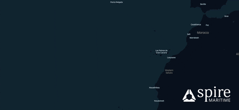
In September 2018 the vessel's AIS data showed it at the port of Ceuta, a small Spanish enclave on the north coast of Africa, more than 2,000 kilometres from the Greek ports it was last recorded at.
“It's truly a mystery ship,” says Georgios Hatzimanolis, an analyst at ship tracking website MarineTraffic, one of several firms to have looked at AIS data of the vessel.
“Since August 2015 it has been switching [AIS] on and off sporadically while making some really strange trips,” Hatzimanolis says.
“One from Genoa to Athens and then it switched it off again for a year and a half, then switched it back.” Hatzimanolis says this is “not normal behaviour” – nor is it normal for a ship to change its name and flag so regularly, he adds.
These strange patterns repeated until the Alta reached Ceuta.
It was at this point that the ship headed for open waters on its fateful final, manned, journey.
It was destined for Haiti.
It ended up in Ireland.
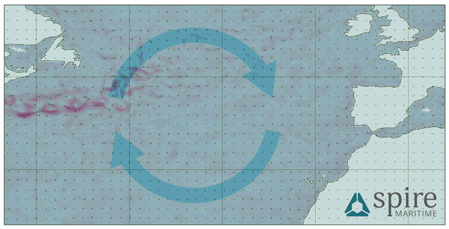
The animation above, produced by analysts at Spire Maritime, shows what happened to the Alta.
It left the Strait of Gibraltar in September 2018, before moving into the Atlantic.
“They have the speed going through the Atlantic,” says Max Abouchar, an engineer at Spire.
When the red line of travel turns white, this is the moment the ship slowed down.
“Somewhere, almost mid-Atlantic they suddenly just stop,” Abouchar says.
The period shown in the animation covers September to October 2018.
When the ship slowed down it is predicted to have been travelling at speeds of around 0.1 or 0.2 knots, which equates to around 0.2 to 0.3 kilometres per hour.
Put bluntly: it was barely moving at all.
“They drifted around a bit, probably just by the currents.
Then they move a little bit quicker, especially East, towards in the direction of Africa.” Abouchar, who uses Spire's data gathered by satellites to monitor currents, says these looped movements are unlikely to just be the sea moving the ship around.
Instead, he speculates, the vessel was either trying to move under its own power or that it was being towed by another vessel.
“Whatever was towing it or driving it gave up after a while,” Abouchar says.
It was around this time that US authorities became involved with the Alta.
In October 2018, the USCGC Confidence, a coastguard ship, is reported to have rescued ten crew from the vessel.
At the time GCaptain reported that the seafarers were stranded on the boat that was around 1,300 miles southeast of Bermuda.
They had been stuck on the ship for 20 days and had received a food supply, dropped by a coast guard plane, on October 2.
“We were conducting a law enforcement patrol near Puerto Rico when we were assigned to assist the crew of the motor vessel Alta,” Confidence commander Travis Emge told GCaptain.
“We traveled over 1,300 nautical miles to get to the disabled ship.” The coast guard said the crew were being taken to Puerto Rico and the ship's owners were being contacted so Alta could be towed back to shore.
But this never happened.
“Maritime is a really low margin commercial endeavour,” says Dana Goward, president of the Resilient Navigation and Timing Foundation, a non-profit which campaigns for better GPS security.
“Except for the cruise line industry, there's not a lot of extra money floating around.
“Actually getting a hold of a real person by the collar and saying, 'come and get your ship' can be a challenge.”
No available data has been able to track the Alta's exact route through the Atlantic to Ireland.
Once the its AIS stopped transmitting – most likely due to it being abandoned – it became far harder to monitor the ship's movements.
While the Alta looks huge when it's nestled against the coast of Ballycotton, in the middle of thousands of miles of Atlantic it's a tiny dot.
Tracking ships that aren't transmitting AIS data is virtually impossible.
“There's certainly nothing off the shelf that I can think of that could provide that kind of long term tracking and warning of other vessels,” Goward says.
“You could hook up an AIS unit with a battery and put it there.
But that would only last a couple of weeks.”
Vessels that disable AIS on purpose are almost always operating illegally.
At the start of 2018, the European Commission opened an investigation into two vessels believe to be turning off their AIS transponders to fish illegally.
On the high seas, so-called dark ships are a big problem.
The US Navy is looking for a way to fix this.
It has issued a tenderfor technology companies to produce a system that can help it “more clearly mark objects in water”.
But that's come too late to help people trace how the Alta reached Ireland.
Previous reports speculate that the Alta may have drifted up the coast of Africa towards the UK and its final resting place.
Abouchar doesn't believe this to be the case.
“It would be against all currents and they would have met quite a bit of traffic,” he explains.
Where the Alta stopped transmitting AIS data is roughly near the centre of where currents in the Atlantic circulate.
During all its months at the mercy of the Atlantic the ghost ship was only spotted once – by the British Royal Navy.
On September 2, 2019, almost a year after its crew were rescued, staff aboard the HMS Protector tweeted they had discovered the Alta in a “strange event”.
The crew put the call out asking if it required any help, but no response was received.
The HMS Protector didn't state its location but analysts looking at its movements say a day after the social media post it was in Bermuda – around 1,300 miles from the last known location of the Alta.
In the grand scale of the ocean, this isn't that far from Canada and Newfoundland.
Ocean current data collected from Spire's satellites and modelling – shown above – gives a clue of how the Alta ended up in Europe.
The animation above shows how currents were moving in the months before the vessel was grounded.
Each arrow shows the direction currents were flowing, with the red overlays demonstrating faster moving streams.
All arrows point to Ireland.
“If you started up North, near Canada and Newfoundland, you would catch a major current stream heading from there and that would have definitely washed you up at Ireland,” Abouchar says.
“It would take quite a while to move the distance it did, until it reached that stream up by Newfoundland.
That's going at one or two knots.”
Despite the slow speed, there was plenty of time between the Alta being seeing by the Royal Navy to the final crossing of the Atlantic.
“With the oceans behaving as they do, if the ship didn't have anyone on it, it would have followed the ocean path and eventually ended up somewhere around the UK or British Isles area,” Abouchar adds.
Ballycotton Bay with the GeoGarage platform (UKHO nautical map)
The MV Alta on the coast of Ireland on March 15, as seen by satellite
Planet Labs Inc
When it finally ran aground in Ireland one member of the local coastguard said it was a “one in a million” chance.
More than a month after it marooned, the Alta remains in the same position.
Ireland's revenue commissioners have become the “receiver of wreck” as a result of it running aground on Irish land.
A person who is believed to be connected to the ship's owner made contact with authorities, but no action has been taken.
"The council continues to liaise with Revenue regarding ownership of the vessel," a spokesperson for Cork County Council says.
The local authorities have scrambling to make the wreckage safe.
A group of teenagers boarded the ship one night.
They recorded a haunting video from inside the vessel, where debris has been thrown around by the power of the ocean.
Officials have airlifted 95 oil barrels from the boat – 62 of these were full.
"The council is engaged with relevant experts to assess whether there are any residual environmental or ecological risks posed by the vessel," a spokesperson for the council says.
Absorbent pads have also been placed around pipes on the vessel that may contain oil.
To stop anyone else boarding the Alta engineers have removed the ship's ladders and closed off all access points.
“It's bad that the Alta came ashore on the Irish coast,” Goward says.
“But it could have been a lot worse: it could have strayed into a traffic lane or the English Channel and someone could have rammed right into it, sunk, and could have had a major loss in life or more of a significant pollution incident.
At least in this instance it was controllable.”