Saturday, June 15, 2013

Book World: ‘Lost Art of Finding Our Way’ explores the many ways to navigate

Long before GPS, Google Earth, and global transit, humans traveled vast distances using only environmental clues and simple instruments.
John Huth asks what is lost when modern technology substitutes for our innate capacity to find our way.
Encyclopedic in breadth, weaving together astronomy, meteorology, oceanography, and ethnography, The Lost Art of Finding Our Way puts us in the shoes, ships, and sleds of early navigators for whom paying close attention to the environment around them was, quite literally, a matter of life and death.
Haunted by the fate of two young kayakers lost in a fogbank off Nantucket, Huth shows us how to navigate using natural phenomena—the way the Vikings used the sunstone to detect polarization of sunlight, and Arab traders learned to sail into the wind, and Pacific Islanders used underwater lightning and “read” waves to guide their explorations.
Huth reminds us that we are all navigators capable of learning techniques ranging from the simplest to the most sophisticated skills of direction-finding.
Even today, careful observation of the sun and moon, tides and ocean currents, weather and atmospheric effects can be all we need to find our way.
Lavishly illustrated with nearly 200 specially prepared drawings, Huth’s compelling account of the cultures of navigation will engross readers in a narrative that is part scientific treatise, part personal travelogue, and part vivid re-creation of navigational history.
Seeing through the eyes of past voyagers, we bring our own world into sharper view.

From Washington Post

‘In this book,” writes John Edward Huth, a professor in the physics department at Harvard University, “I examine . . . the various ways humans are able to navigate, using simple instruments and environmental clues.”
That announced purpose seems modest enough, but “The Lost Art of Finding Our Way” is, in fact, a rigorously demanding historical survey — a college course in a book — explaining how people have, over time, managed to make their way from place to place.


Primitive Navigation - Course Trailer

While there’s much to enjoy in Huth’s anecdotes about Viking voyages, canine trail-marking, the positioning of churches and the development of celestial navigation, his constant (if necessary) use of maps, diagrams, graphs and geometry will challenge some readers.
He does, however, write plainly and gracefully (note the understated wordplay of his book’s title).
There is, moreover, a good deal of romance just in the terminology of his wide-ranging subject: “Dead reckoning,” “the horse latitudes,” “the westerlies,” “Mercator projection,” “nautical twilight.”
This last, Huth explains, was for sailors “the magical time between the world of day and night when both the horizon and the brighter stars would be visible.”
It lasts about half an hour.

“Woods shock,” however, is far from magical, being that “state of anxiety induced by being lost in a wilderness setting.”
More often than not, increasingly desperate hikers end up walking in circles.
At least a few of us, alas, suffer from its more mild urban equivalent.
Let me be personal for a moment.


Huth notes early on that there are two modes of navigational understanding: route knowledge and survey knowledge.
In the first, we understand our environment by traversing known paths and familiar landmarks.
In effect, we learn by rote certain patterns to travel from one location to another, subconsciously ticking off an established order of steps.
Turn right out the driveway.
Take a left at the Sunoco station.
Follow 16th Street to Military Road. And so forth.

This is — as I know all too well — a very limiting navigational mind-set.
Make one false step or alter any aspect of the standard pattern, especially at dark, and somehow you’re suddenly lost, driving with mounting wretchedness and confusion, fully aware that the clock is ticking and you’re going to be late for your child’s soccer game or that important dinner party.
Most of the time there is nothing for it but to ask for directions from a passerby or stop at a gas station or 7-Eleven.
Even then you are likely to slightly misunderstand what you’re told so that you need to repeat the same shameful inquiries once, twice or even three times before you finally find a street or location you recognize.

Fortunately, most people and some animals possess better brains than mine.
They display “survey knowledge,” what Huth calls “a complete familiarity with an environment.
In your mind you see the region as if you are hovering over the landscape and seeing everything below in miniature.”
Those with this more holistic grasp of their surroundings are the people who can take shortcuts, who can respond to a traffic jam by following an alternate route, who, in effect, always know precisely where they are on a mental map.

One of the repeated themes of “The Lost Art of Finding Our Way” is that even the most confused of us can improve our navigational understanding by paying closer attention to the world around us.
We can check our direction by the sun or flight of birds or the movement of waves, note whether we are going up or downhill, confirm our location in myriad ways from details around us.
Still, we should always be wary of what is called “bending the map.”


This phrase describes the initial response of those who, having gone astray in an unfamiliar environment, initially deny that they are lost, even though things around them do not seem quite right.
People, it almost goes without saying, stubbornly search for those details that confirm what they want to believe, ignoring evidence to the contrary.
Huth tells the story of the “Hubbard-Wallace-Elson Expedition,” in which three explorers in 1903 Labrador disastrously mistook one river for another, then persisted in believing they were on the right path, despite every evidence to the contrary.
By the time the three decided to retrace their steps, they were starving.
The weakest man was finally abandoned and, essentially, left to die in his tent.

As Huth stresses, again and again, our world is packed with directional information, if we only know how to see and grasp it.
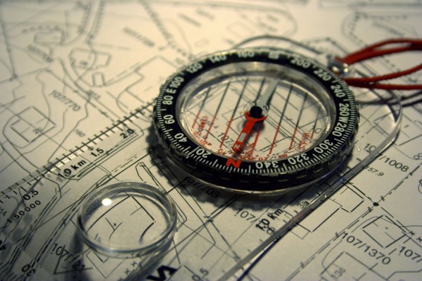
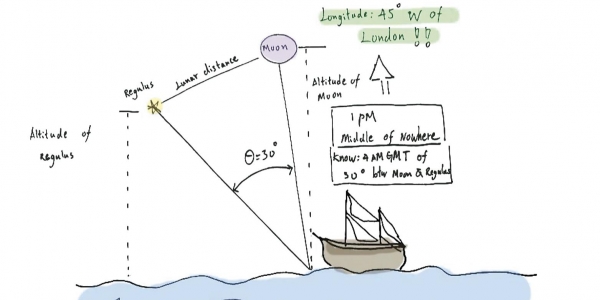
He discusses navigating by the sun and the stars; the use of the compass, sextant and marine chronometer; the determination of latitude and longitude; the flight of birds; the nature of currents and gyres.
He touches on the refraction of light on the horizon (“looming”), the creation of mirages and even offers an explanation for the universal myth of the Great Flood: When you travel away from the shore in a boat, the land eventually seems to sink below the horizon.
When you return, the highest elevations appear first as the boat approaches land.
To those who believed in a flat Earth, the visual effect must have been one of the ocean engulfing the land and then of the waters receding.

This taste for thoughtful speculation reappears in the last chapter, when Huth slightly fictionalizes the legend of Baintabu, a female navigator from Abemama in the Gilbert Islands.
In Huth’s source documents, Baintabu was said to have accompanied a raiding party to Tarawa but on the way back was “unceremoniously thrown off the lead canoe and rescued by the last canoe in the flotilla.
Only the last canoe with Baintabu on board made it back to Abemama.” Huth’s story imagines the young woman’s family background, education and nautical accomplishments.
Late in life, she reminds a disciple: “You must remember that no one sign in navigation is reliable, but several signs in combination are.
You must always ask yourself, ‘Are there other ways I can prove to myself where I am, and where I am going?’ ”

“The Lost Art of Finding Our Way” is, as I said, a learned and encyclopedic grab bag, packed with information drawn from study and Huth’s own experience.
Still, it may be too technical in places for practical use.
For that, one might prefer Tristan Gooley’s “The Natural Navigator” (2011), enthusiastically reviewed for The Post by my colleague Tim Smith and just published in paperback.
After all, you might forget your smartphone one day, or your GPS device could go haywire, and before you know it, you find yourself alone in the wilds of Northern Virginia, with night coming on. Now, which way is the Potomac?

Links :

Friday, June 14, 2013

Warm ocean causing most Antarctic Ice shelf mass loss

Rates of basal melt of Antarctic ice shelves (melting of the shelves from underneath) overlaid on a 2009 mosaic of Antarctica created from data from NASA's Moderate Resolution Imaging Spectroradiometer (MODIS) instrument aboard NASA's Terra and Aqua spacecraft.
Red shades denote melt rates of less than 5 meters (16.4 feet) per year (freezing conditions), while blue shades represent melt rates of greater than 5 meters (16.4 feet) per year (melting conditions).
The perimeters of the ice shelves in 2007-2008, excluding ice rises and ice islands, are shown by thin black lines.
Each circular graph is proportional in area to the total ice mass loss measured from each ice shelf, in gigatons per year, with the proportion of ice lost due to the calving of icebergs denoted by hatched lines and the proportion due to basal melting denoted in black.
Image credit: NASA/JPL-Caltech/UC Irvine/Columbia University 

From NASA

Ocean waters melting the undersides of Antarctic ice shelves are responsible for most of the continent's ice shelf mass loss, a new study by NASA and university researchers has found.

Scientists have studied the rates of basal melt, or the melting of the ice shelves from underneath, of individual ice shelves, the floating extensions of glaciers that empty into the sea.
But this is the first comprehensive survey of all Antarctic ice shelves.
The study found basal melt accounted for 55 percent of all Antarctic ice shelf mass loss from 2003 to 2008, an amount much higher than previously thought.

 Pine Island Bay and Amundsen Sea (NGA charts)
>>> geolocalization with the Marine GeoGarage <<<

Antarctica holds about 60 percent of the planet's fresh water locked into its massive ice sheet.
Ice shelves buttress the glaciers behind them, modulating the speed at which these rivers of ice flow into the ocean.
Determining how ice shelves melt will help scientists improve projections of how the Antarctic ice sheet will respond to a warming ocean and contribute to sea level rise.
It also will improve global models of ocean circulation by providing a better estimate of the amount of fresh water ice shelf melting adds to Antarctic coastal waters.

The study uses reconstructions of ice accumulation, satellite and aircraft readings of ice thickness, and changes in elevation and ice velocity to determine how fast ice shelves melt and compare the mass lost with the amount released by the calving, or splitting, of icebergs.

 Calving front of an ice shelf in West Antarctica.
The traditional view on ice shelves, the floating extensions of seaward glaciers, has been that they mostly lose ice by shedding icebergs.
Image credit: NASA/GSFC/Jefferson Beck

"The traditional view on Antarctic mass loss is it is almost entirely controlled by iceberg calving," said Eric Rignot of NASA's Jet Propulsion Laboratory in Pasadena, Calif., and the University of California, Irvine.
Rignot is lead author of the study to be published in the June 14 issue of the journal Science.
"Our study shows melting from below by the ocean waters is larger, and this should change our perspective on the evolution of the ice sheet in a warming climate."

Ice shelves grow through a combination of land ice flowing to the sea and snow accumulating on their surface.
To determine how much ice and snowfall enters a specific ice shelf and how much makes it to an iceberg, where it may split off, the research team used a regional climate model for snow accumulation and combined the results with ice velocity data from satellites, ice shelf thickness measurements from NASA's Operation IceBridge -- a continuing aerial survey of Earth's poles -- and a new map of Antarctica's bedrock.
Using this information, Rignot and colleagues were able to deduce whether the ice shelf was losing mass through basal melting or gaining it through the basal freezing of seawater.

 This photo shows the ice front of the ice shelf in front of Pine Island Glacier, a major glacier system of West Antarctica.
The image was taken during the NASA/Centro de Estudios Cientificos, Chile (CECS) Antarctic campaign of Fall 2002.
Image credit: NASA/JPL-Caltech/UC Irvine

In some places, basal melt exceeds iceberg calving.
In other places, the opposite is true.
But in total, Antarctic ice shelves lost 2,921 trillion pounds (1,325 trillion kilograms) of ice per year in 2003 to 2008 through basal melt, while iceberg formation accounted for 2,400 trillion pounds (1,089 trillion kilograms) of mass loss each year.

Basal melt can have a greater impact on ocean circulation than glacier calving.
Icebergs slowly release melt water as they drift away from the continent.
But strong melting near deep grounding lines, where glaciers lose their grip on the seafloor and start floating as ice shelves, discharges large quantities of fresher, lighter water near the Antarctic coastline.
This lower-density water does not mix and sink as readily as colder, saltier water, and may be changing the rate of bottom water renewal.

This photo shows the ice front of Venable Ice Shelf, West Antarctica, in October 2008.
Image credit: NASA/JPL-Caltech/UC Irvine

"Changes in basal melting are helping to change the properties of Antarctic bottom water, which is one component of the ocean's overturning circulation," said author Stan Jacobs, an oceanographer at Columbia University's Lamont-Doherty Earth Observatory in Palisades, N.Y.
"In some areas it also impacts ecosystems by driving coastal upwelling, which brings up micronutrients like iron that fuel persistent plankton blooms in the summer."

 Filchner-Ronne Ice shelf (NGA charts)
>>> geolocalization with the Marine GeoGarage <<<

The study found basal melting is distributed unevenly around the continent.
The three giant ice shelves of Ross, Filchner and Ronne, which make up two-thirds of the total Antarctic ice shelf area, accounted for only 15 percent of basal melting.
Meanwhile, fewer than a dozen small ice shelves floating on "warm" waters (seawater only a few degrees above the freezing point) produced half of the total melt water during the same period.
The scientists detected a similar high rate of basal melting under six small ice shelves along East Antarctica, a region not as well known because of a scarcity of measurements.

The researchers also compared the rates at which the ice shelves are shedding ice to the speed at which the continent itself is losing mass and found that, on average, ice shelves lost mass twice as fast as the Antarctic ice sheet did during the study period.

"Ice shelf melt doesn't necessarily mean an ice shelf is decaying; it can be compensated by the ice flow from the continent," Rignot said.
"But in a number of places around Antarctica, ice shelves are melting too fast, and a consequence of that is glaciers and the entire continent are changing as well."

Links :
  • Nature : Oceans melt Antarctica's ice from below

Thursday, June 13, 2013

Antarctic's mountains revealed by sharpest map yet


 The bedrock beneath Antarctica.
Our understanding of what lies beneath the world's biggest ice sheet has taken another leap forward. This video strips away Antarctic ice to reveal a new, and much more detailed map of the bedrock below.
This map, called Bedmap2, was compiled by the British Antarctic Survey and
incorporates millions of new measurements, including substantial data sets from NASA's ICES at satellite and an airborne mission called Operation IceBridge.
Credit: NASA's Goddard Space Flight Center

From NationalGeographic

Buried under miles of ice, Antarctica's mysterious mountain ranges are coming into sharper focus thanks to a new map.

Created by the British Antarctic Survey, Bedmap2 drew upon millions of new measurements of the frozen continent's surface elevation, ice thickness, and bedrock topography from a wide variety of sources collected over several decades.

Due to technological advances, Bedmap2 is also higher in resolution, more precise, and covers more of the continent than the original Bedmap, produced more than ten years ago, according to Charles Webb, deputy program scientist for cryospheric sciences at NASA headquarters. Earth's frozen regions are collectively called the cryosphere.

For example, the original Bedmap relied mostly on ground-based measurements, which limited the scientists in terms of how much land they could cover, Webb noted.

But a NASA program called Operation IceBridge sends out airplanes that fly over the entire continent.
The airplanes are equipped with lasers that measure the surface mountains' heights and other features, as well as ice-penetrating radar that maps subglacial bedrock—"giving [scientists] a more 3-D picture of the ice sheet itself," Webb said.

These images depict the differences between Antarctica's ice sheet with its underlying topography.
(Vertical scale has been magnified by a factor of 17 to make terrain features such as mountains and valleys more visible.)

In addition, the new data has revealed several smaller features—both on Antarctica's surface and buried under the ice—that were missed in the previous Bedmap effort.
(Also see "First Detailed Pictures: Antarctica's 'Ghost Mountains.'")

To Webb, "the piece that's exciting is that the increased resolution ... gives us better insight into what drives the flow of the ice."

For instance, scientists want to know the shapes of mountains and rocks to model how fast ice will move across these features on its way to the ocean, where the ice can melt and contribute to sea level rise, he said.

Overall, loss of polar ice has contributed about 11.1 millimeters (0.03 feet) to global sea levels since 1992, research shows. Sea levels are currently rising at a rate of 3.2 millimeters a year.

Links : 
  • NASA :  NASA's IceBridge Mission Contributes to New Map of Antarctica
  • GeoGarage blog : Antarctic's hidden world revealed

Wednesday, June 12, 2013

A breakthrough in how we work to protect our oceans


The wild and beautiful Bering Sea

From Huffington Post

The Bering Sea is known to scientists and conservationists as one of the most remarkable places on Earth -- a home to sponges, coral, fish, crab, skates, sperm whales, orcas, Stellar sea lions, and a vast array of other species all part of a delicate ecosystem extremely vulnerable to human activity.

But here's what's new -- as of this week, the Bering Sea is remarkable for another reason -- it's the impetus for a an amazing breakthrough in the way we work to protect our oceans.

 <<< geolocalization with the Marine GeoGarage <<<

On Monday in Juneau, Alaska, the North Pacific Fishery Management Council voted to identify key coral areas in the Bering Sea canyons and consider measures to protect them.
While this may sound like a routine decision in a far off place, it's anything but the status quo.

The council's decision comes in the middle of an ongoing campaign to protect the "Grand Canyons of the Sea" from the pollock industry that uses destructive fishing gear like bottom trawlers that destroy fragile corals and threaten life in the Bering Sea.
You may not have heard much about pollock day-to-day, but it's in fish sticks, fast food fish sandwiches, and even imitation crab.
It's a big deal fish -- in fact, some people even call it the "billion dollar fish" because of how much the industry depends on it.

This campaign, like most conservations initiatives, has gathered together numerous green groups like Greenpeace, the World Wildlife Fund, and Mission Blue.
But what's different about this campaign is that major seafood retailers like Safeway, Trader Joe's, and, yes, even McDonald's have looked beyond their next quarters' earnings to the long-term viability of our environment (and their products)
These business leaders have admirably urged the Council to look further into the available science to protect the canyons from destructive fishing, because they too want the Bering Sea to have a sustainable foundation for the future.
We know from what we've seen from the oceans around the world that a thriving ecosystem today can turn into a wasteland tomorrow without sustainable management, so the problem is urgent.

What else is new with this campaign is the truly remarkable amount of citizen engagement.
This week, as the Council deliberated in Juneau, everywhere they went flyers, posters, and banners held by activists reminded them that more than 100,000 people were urging them to protect the canyons -- an unprecedented amount of public input in this process.
When Council member John Henderschedt spoke to his breakthrough motion yesterday he began by saying, "thanks to all who provided comments -- your voices are important to this process, and they have been heard."

If the industry and government operated in secret, who knows what it would take for them to work sustainably.
But because Greenpeace and other conservation groups have been able to show the wider world what's at stake in the Bering Sea, people have been able to decide for themselves how they want their world.
Greenpeace has had the privilege of taking this message to the decision-makers in government and industry to create a new way forward, one that includes more voices than just that of the highest bidder.

The struggle to protect the "Grand Canyons of the Sea" is far from over, but on Monday in Juneau something remarkable happened, something that might just signal a sea change in how we protect our oceans.

Links :
  • Greenpeace : Protect the Bering Sea
  • National Geographic : Sylvia Earle’s 19th “Hope Spot” named in Bering Sea canyons
  • Alaska Public : Fisheries regulators take steps toward conservation of Bering Sea canyons

Tuesday, June 11, 2013

World's most dangerous oceans for shipping identified

This WWF infographic shows the number of accidents at sea in the world's most dangerous waters.

From Ibtimes 

A new study commissioned by the World Wildlife Fund for World Oceans Day, pinpoints the planet’s most dangerous oceans and describes how shipwrecks are likely to increase in the coming years because of expanding fleets and a warming climate.

Scientists at Southampton Solent University, who carried out the research for WWF, said that while the number of accidents at sea has fallen by about 18 percent since 1980, many incidents occur in areas of environmental significance, such as the South China Sea and East Indies, eastern Mediterranean, North Sea, Black Sea and British Isles.

The sea areas where ships continue to be lost are also waters of environmental significance

The North Sea is one of the most intensively sailed seas in the world, with more than 120,000 ship movements each year, according to Simon Walmsley, marine manager at WWF.
“Shipping lanes around the U.K. are already some of the world’s busiest and will get busier as the global fleet expands,” he noted.
“The risk of accidents and environmental disaster is only going to increase, so efforts must be made to lower the risk.”

A container ship sails past barges during foggy conditions at Hong Kong's Victoria Harbour March 15, 2010.
photo Bobby Yup, Reuters

Over in the South China Sea and East Indies, the world’s top accident area, concerns are even greater. “Since 1999, there have been 293 shipping accidents in the South China Sea and East Indies, home of the Coral Triangle and 76 percent of the world’s coral species,” Walmsley said.
“As recently as April of this year, we’ve seen a Chinese fishing boat run aground on a protected coral reef in the Philippines that had already been damaged by a U.S. Navy ship in January.”

The number of ships sailing the open oceans has increased dramatically over the past 15 years to about 105,000 from roughly 85,000.
According to the WWF report, fishing vessels account for nearly one-quarter of the vessels lost at sea, while general cargo ships make up more than 40 percent. Cargo ships tend to operate on short shipping routes associated with tramp trading “where ships don’t have a set route and pick up opportunistic trade, particularly in Southeast Asia,” the report said.

Walmsley noted that in the past we’ve seen reviews of safety and environment measures only after major accidents.
“That needs to change if we want to maintain healthy seas,” he said.

Oil spill from sunken tanker Prestige on the Galician Costa de la Muerte near Camelle, Spain.
© WWF / Raúl Garcia

The scale of an environmental risk can be affected by the type of cargo onboard, such as oil and other hazardous substances, and the sensitivity of the marine area where the accident occurs.
Walmsley pointed to the 2002 sinking of the Prestige oil tanker, when more than 70,000 tons of oil was released into the Atlantic Ocean off the Spanish coast, as one prominent recent example.
“The Prestige oil spill caused not only environmental impacts but economic losses estimated at €8 billion [$10.4 billion],” he said.
“Even small-scale accidents in very sensitive environments, like the Great Barrier Reef, can have profound environmental consequences.”

The study expressed concerns about new ports under construction near the Great Barrier Reef that would be used in the transport of coal from Australia but also boost traffic in the area, thus increasing risks.
A recent National Geographic article called Australia “the face of climate change to come,” and the WWF report noted that increased storm surges, changing wind and wave patterns, and extreme weather events will all exacerbate the risks of foundering, leading to potentially catastrophic environmental destruction.

According to the scientists at Southampton Solent University, some 50 percent of all accidents are caused by foundering, where a boat sinks in rough weather, leaks or breaks in two.
They warn of a high probability of more accidents unless precautionary measures are put in place to address the increasing risk factors.

Petrol tanker waiting for its cargo, Fujeirah port, United Arab Emirats, Indian Ocean
© © Michel Gunther / WWF-Canon

“We really want to see the shipping industry promote greater owner and operator responsibility and encourage owners to register with better flag states, the country which a vessel is registered to,” Walmsley said
 “Additionally, irresponsible and badly performing owners and countries need to be exposed in order to motivate them to significantly increase their standards, which will decrease the number of accidents we see still occurring today.”

 The Rena, grounded on the Astrolabe reef 14 miles from Tauranga Harbour on New Zealand’s North Island, got stuck during bad weather and rough seas in October 2011. (AP)

A separate study, released this year by Allianz Global Corporate and Specialty Insurance, pointed to a different area of shipping as the biggest concern: human error.
In its annual “Safety and Shipping Review,” Allianz researchers cited the largest accidents in 2012 -- the Costa Concordia off the coast of Italy, the MV Rena off the coast of New Zealand and the Rabaul Queen off Papua New Guinea -- as evidence supporting their theory.

“For some commercial ship owners, especially in the hard-pressed bulk cargo and tanker sectors, there is little money for maintenance and little money for training,” Sven Gerhard, Allianz's global marine head of hull and marine liabilities, explained.
He said the Maritime Labor Convention of 2006, which comes into force later in 2013, would help improve safety by improving the working conditions of seafarers.

Links :

Monday, June 10, 2013

US NOAA update in the Marine GeoGarage


14 charts have been updated in the Marine GeoGarage
(NOAA update mi-May 2013-1st week of June 2013)

NOAA Charts Show New IMO Traffic Separation Scheme off California
NOAA has updated a series of raster and electronic navigational charts to comply with routing regulations approved late last year by the International Maritime Organization (IMO COLREG.2/Circ.64,December 4, 2012).
The routing establishes a new traffic separation scheme off the northern coast of California, effective June 1

see GeoGarage blog : California shipping lanes moved in attempt to avoid killing whales

  • 11324 Galveston Bay Entrance Galveston and Texas City Harbors
  • 11356 Isles Dernieres to Point au Fer
  • 11428 Okeechobee Waterway St. Lucie Inlet to Fort Myers; Lake Okeechobee
  • 11542 Florida Keys Sombrero Key to Sand Key
  • 12326 Approaches to New York Fire lsland Light to Sea Girt
  • 12332 Raritan River Raritan Bay to New Brunswick
  • 12368 North Shore of Long Island Sound Sherwood Point to Stamford Harbor
  • 13223 Narragansett Bay. Including Newport Harbor
  • 13287 Saco Bay and Vicinity
  • 13298 Kennebec River Bath to Courthouse Point
  • 18649 Entrance to San Francisco Bay
  • 18724 Port Hueneme And Approaches;Port Hueneme
  • 18725 Port Hueneme to Santa Barbara;Santa Barbara;Channel Islands Harbor and Port Hueneme;Ventura
  • 18746 San Pedro Channel;Dana Point Harbor
Today 1024 NOAA raster charts (2166 including sub-charts) are included in the Marine GeoGarage viewer.


How do you know if you need a new nautical chart?
See the changes in new chart editions.
NOAA chart dates of recent Print on Demand editions

Note : NOAA updates their nautical charts with corrections published in:
  • U.S. Coast Guard Local Notices to Mariners (LNMs),
  • National Geospatial-Intelligence Agency Notices to Mariners (NMs), and
  • Canadian Coast Guard Notices to Mariners (CNMs)
While information provided by this Web site is intended to provide updated nautical charts, it must not be used as a substitute for the United States Coast Guard, National Geospatial-Intelligence Agency, or Canadian Coast Guard Notice to Mariner publications

Please visit the
NOAA's chart update service for more info.

Herbert Nitsch : back from the abyss


On June 6, 2012, the apnea diver Herbert Nitsch sought to improve his own world record in freediving by another 100 feet - to 800 feet (244 meters).
The record attempt off the Greek island of Santorini was to only be the beginning of his "1,000 feet" project.
Despite painstaking preparation, on this early summer afternoon Nitsch experienced the worst-case scenario.
Unconscious, he had to be brought to the surface by rescue divers - after reaching a depth of more than 818 feet (249.5 meters).

From DeeperBlue

For almost a year afterwards, there was no information whatsoever either about the accident or about Herbert Nitsch’s condition.

However, this documentary accompanied him during his incredible recovery, removed from the public eye, and offers world exclusive documentary material on the months of preparation leading up to and including the life-threatening accident in Santorini, the difficult rehabilitation in specialized clinics and finally, Nitsch's way back into the stillness of the underwater world of the sea.


Herbert Nitsch talks about his fateful dive and recovery :

“On June 6, 2012, I almost lost my life while pursuing a new world record.
First and foremost I would like to thank all those who believed in me and supported me since the record.
It played a big role in my well being and I can’t thank you enough for the concern, the care you gave to me. As freedivers know better than anyone, when you’ve been quite far down, getting back up is the only way to go – and all of you helped.
On that windy Wednesday in Santorino, Greece, the aim was to reach 800 feet (243.84 meters) with the no-limit freediving discipline, of which I already held the 700 feet world record. Several years of preparation, sled-design, safety measures and thorough training led up to this rather high profile event.
I did reach the record depth of 818.6 feet (249.5 meters), however, on the way back to the surface I lost consciousness due to narcosis (a first in free diving).
The sled and safety devices were designed in such a way, that it would stop at 10 meters depth, which it did, within reach of the safety divers.
Thanks to the well organized emergency rescue plan as part of my extensive pre-dive safety preparations, all went as scheduled after I reached the surface.
The original plan was that I would slow down the sled between 100 and 70 meters below the surface on the way back up, and have a one minute decompression stop at approximately 10 meters depth.
Because of the blackout due to narcosis (at approximately 100 meters below the surface), I was not able to slow down the sled, and thus it continued on to 10 meters where it stopped as programmed. Fortunately the safety divers brought me right away to the surface.
Because this omitted the planned 1 minute decompression stop, the result was serious DCS (decompression sickness), which is equivalent in my case to several brain strokes with severe initial consequences.
Prior to reaching the surface, I did regain consciousness and had the clarity of mind to ask for oxygen, to descend back to about 10 meters for about 20 minutes thus avoiding some impact of DCS. Underwater I realized that things were wrong in my head.
And once back to the surface I had to be brought with urgency by speedboat to the port of Fira, onward by ambulance plane to the hospital and decompression chamber in Athens.
After a good week’s stay in Athens, I was flown by ambulance plane to Murnau in Southern Germany to undergo recompression therapy for about a month.
This was followed by additional months of rehabilitation in Vienna to learn to walk, talk and move around again.
It was not an easy road.
During the course of rehabilitation I went into depression, wondering if I would ever get back to normal life again, to the point of contemplating jumping out of the window to end the mental chaos and physical limitations I endured.
Fortunately I realized that the second floor of the rehab center would not do the trick, so I gave up rather quickly on that idea.
Despite the slow progress and initial depression, I kept my motivation alive and made the decision to do anything to bring my life back to what it used to be.
I started a strict regime of super foods, healthy living, exercise and listening to my own intuition (even if this often meant disregarding well-meaning advice from doctors and experts).
I adopted the same attitude that I always used with freediving: pushing boundaries, further exploring the human potential and setting new limits where we thought we already knew everything.
I am doing well now.
There are still some physical challenges to deal with related to coordination and speech, which are typical consequences of neurological damage.
But from what I hear, those who have no idea of my condition do not really notice these limitations, which is a rather positive sign.
In January and February of 2013, I went with my father for a month trip in the South Pacific, where I lectured onboard a luxurious cruise liner, and started free diving again. It felt great to be back in the water.
In May I went back to Palau for freediving, and it made me realize once more that there is so much yet to explore in the deep blue.
It was a deliberate choice to keep quiet from the media for all this time since June 6 of last year until now.
After the record dive last year, the attention we received was overwhelming.
Because I was not in a position to make my own statements during most of that time and was not sure about my recovery and progress, I decided that healing had priority over media for the time being.
Also because media often misinterprets events or interviews, I decided to wait so I could tell my own story in my own words when the time is right.
Looking back, I am utterly convinced that my dive plan was realistic and feasible.
But what was not, was the way we conducted the dive under the forced conditions of that particular day.
I should have postponed the dive, prepare better and let the weather settle, before deciding to go for it.
Things could then have been different.
But life does not work backwards and even though I was obviously the one to pay the highest price for it, all those around me, family, friends, team, followers and supporters were also affected to some extent.
The support I received from everyone greatly contributed to my motivation and made my recovery easier.

A very thorough documentary by Red Bull will be aired June 6, 2013 (exactly one year after the record) around the whole event, including various phases of the recovery process and never seen before pictures.
The film team was also with me in the South Pacific for a while this January on the cruise, which is also featured in the documentary.
Lectures and writing will be the main focus for me in the coming months, along with more travels and new ideas linked to the underwater world.
I plan to work more towards the protection of the oceans, but also have in mind to design a new kind of submersible and new ways to explore the oceans.
Competitive freediving is not likely to be part of the future, but for the rest, I am still the same I used to be; the will to create new ways to achieve new things never left me.
I truly look forward to sharing more good news with you in the future.“

Links :

Sunday, June 9, 2013

Round the Island race 2013 timelapse

is a row of three distinctive stacks of chalk
that rise out of the sea off the western extremity of the Isle of Wight, UK

>>> geolocalization with the Marine GeoGarage <<<

Congratulations go to Sir Ben Ainslie and his all-British crew aboard his AC 45 catamaran J.P. Morgan BAR, from Solent Refit, the preparation base for the catamaran challenge.
Their craft trounced the existing Round the Island Race multihull record, which had stood for 12 years, by an impressive 16 minutes, finishing in 2 hours and 52 minutes across the course.
The previous multihull Race record was held by offshore legend Francis Joyon, who completed the 50 nautical mile 2001 course in just 188 minutes.