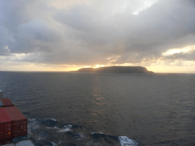
This made me and Sigurd the first ones ever to have crossed the North Sea solo to join the Up Helly Aa- festival on these beautiful islands...
Some say crazy, I say crazy not to give it a try.
This is how we develop and grow.
Staying safe all the time wont get you anywhere.
The video was hard to make.
Its all about having the effort to pick up the camera when you really dont want to, and most important, trying to make a story out of it..
Seasick, cold and wet every minute.
I loved it.
Its all about making a plan and follow it.
Theres only plan A.
You dont think about plan B before you are forced to!
Stay on your course and hold it steady!
Youve might heard the words often attributed to Mr. Winston Churchill:
"If your going through hell, keep walking" ;)
There is an old anecdote about a ship going up-river in a port when another ship is sighted on the radar.
There is already a marine pilot onboard who informs that there is no mention of outbound traffic and the other ship on the radar is probably at anchor.
Just to confirm, he calls the ship on VHF, identifying her by geographical position and asks, “Vessel in position XYZ are you at anchor?”; to which, the other ship replies, “ This is the ship in position XYZ, yes, I am a tanker”.
The ensuing confusion results in an accident.
Once the humour wears off, the readers who use VHF for communication every day at sea will realise that this situation is actually quite possible.
Use of VHF for collision avoidance is always debatable and whether to use it or not will depend on a case-to-case basis.
It is extremely common in certain parts of the world and in pilotage waters where changes of miscommunication are minimum.
1. Don’t Solely Rely On Radar: At open sea from his cabin, the Captain saw a small fishing boat in close proximity to the bow of own ship.
He rushed up to bridge, engaged hand steering and avoided a collision.
In this case, the officer of the watch had not sighted the fishing craft as he was navigating solely by radar and this target was not picked up due to its size.
At that time OOW was altering course for another ship that was seen on radar.
In this case, had the officer of the watch kept proper lookout by actually looking out of the bridge window the situation could have been avoided.
There is saying that nothing beats the “Mark 1 Eyeball method of navigation” and despite technological advancements this still holds true, a trained human eye can pick up a lot of information and brain can process it faster than a complex algorithm spits it out on radar display screen.
Because of sunrise you can spot a boat in water,
but if water is choppy or it’s sunset time it will not be easy to sight.
2. Radar target must always be verified visually: In restricted visibility and an area known for dense traffic, the lookout on duty informed OOW about a target sighted right ahead on the radar.
The officer of the watch did not take any action as he assumed that the target was either a fishing craft that would move away as the ship got closer to it or it was a false echo.
This resulted in a collision with another ship that was stopped and drifting.
In the above case altering course even for a “false echo” would have been the best action to ensure vessel safety.
Safe navigation using radar can be done only when the navigator is confident in his understanding of the equipment and knows its limitation.
During the times when radars were not used 24X7 there was a term called “Fairweather practice”, it is still relevant today.
This meant that best use was made of opportunity to use radar whenever it was available and a mental image was built up which would help in comprehending radar picture during restricted visibility.
Now with increased AIS dependence, there is even less use made of automatic radar plotting aid (ARPA) function of radar.
Radar target must always be verified visually.
Over a period of time just by looking at echo and its movement navigator will be able to ascertain the type of target being painted.
3. Don’t Solely Depend On Safety Management System: While approaching port and after plotting position on the chart, the navigating officer informed the Captain that the vessel was North of intended track and he should come South to counteract that.
On the basis of the feedback, the captain started adjusting the course, but the radar picture of landmarks and navigator’s assessment did not match.
So the Captain checked for himself and realized that OOW had plotted latitude incorrectly, the vessel has just crossed The Equator and was in the Southern hemisphere.
Similar to this incident is when during the crossing of Greenwich or meridian or 180 ° longitude position is marked East instead of West or vice versa.
With an increased use of ECDIS possibility of such errors is minimized.
But what remains missing from navigators’ understanding is the principle of monitoring a ship’s position.
They depend on company Safety Management System for guidance and then regardless of their own situation, plot positions at prescribed intervals from SMS.
This doesn’t help because SMS can provide guidance but you as a navigator must make an educated decision.
A simple rule of thumb to remember here is that “between two successive position plots a vessel should not be in danger”.
Whenever a navigator plots position on a chart, it should be followed with a dead reckoning position (DR position), which will give a rough estimate of vessel location at the time of next plotting.
On basis of DR, the frequency of plotting can be increased or decreased.
It will be easier to comprehend for modern navigator if this is compared to look ahead function of ECDIS.
4. Read The Buoys Carefully: An experienced chief officer was taking the ship to pick up the pilot in a buoyed channel.
He was little nervous as he was being assessed for his ship handling skills by the Captain.
After entering the channel, the ship started setting and starboard hand lateral buoy was sighted right ahead.
Seeing the buoy right ahead, the Chief officer immediately ordered hard to starboard, Captain overrode his order, realigned the ship again and handed over con back to him.
Somewhat similar to East West North South cases mentioned above, this can happen during a lapse of concentration resulting in confusion regarding the colour of buoys and which side to pass them.
A common reason for this to happen is due to the different colour of buoys in IALA regions – region A and region B or inside some ports, the direction of the voyage will change (clockwise around landmasses), or in case of preferred channel buoys.
Such confusion can be kept to the minimum by remembering, “can to port – cone to stbd” when inbound, this will reverse when outbound.
5. Always Monitor The Rudder Angle: In a busy traffic separation scheme, the Captain had the con of the vessel and OOW was communicating with VTS.
when the lookout reported that a stationary fishing boat on the starboard side had now started moving and was crossing the bow.
Captain verified the movement of the target on the radar and ordered to helmsman “starboard 20”.
At this time, the bridge telephone rang and was answered by Captain.
After completing the telephone conversation, when he looked up, he noticed that fishing boat was still not clear of the ship’s bow and he ordered: “hard at starboard”.
At this time bridge team realized that though the helmsman was repeating the order, he was actually applying helm in the opposite direction.
It is always essential to monitor the rudder angle indicator (RAI) to break such chain of error.
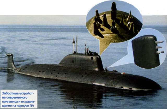
Newly declassified documents show that even the most secretive submarines leave a trail.
In the late 1980s, the Soviet Union claimed a feat many military experts thought impossible.
K-147, a Victor-class nuclear-powered attack submarine, secretly followed the trail of a U.S. boomer (most likely the USS Simon Bolivar) in an underwater game of chase that continued for six days.
U.S. observers at the time thought the Soviets lacked the tech for effective sonar, at least in comparison to the capabilities of the U.S. and its NATO allies.
Now, a newly declassified CIA report shows how hunter submarines like the K-147 went on secret missions to track American subs without using sonar at all.
The CIA's Directorate of Science & Technology produced the report onSoviet Antisubmarine Warfare Capability in 1972, but it was declassified only this summer.
Even forty-five years on, lines, paragraphs, and even whole pages are redacted.
A lengthy portion about Soviet technology under development gives details never previously revealed about devices with no Western equivalents.
While NATO were concentrating almost all their efforts on sonar, the Russians created something else entirely.
Why Sonar Is King
Seawater blocks radio waves.
So radar, while effective on the surface, is useless underwater.
Sound waves, on the other hand, travel better through water than they do through air, and as early as WWI they were put to work finding submarines.
Sonar comes in two basic types.
There's active sonar, which sends out 'pings' that are reflected by the target, making it an underwater version of radar.
Passive sonar, on the other hand, is based on sensitive listening devices that can pick up sound from a sub's engines or propeller—and unlike active sonar, it does not give away your position.
Depending on conditions, sonar can find a submarine from many miles away and in any direction.
The U.S. and its allies developed sophisticated sonar systems, which soon became so effective that other methods of detection were left behind or forgotten.
For decades, non-acoustic methods were considered inferior for being limited in range and reliability compared to sonar.
"It is unlikely any of these methods will enable detection of submarines at long ranges," concludes a 1974 intelligence report.
In the USSR, it was a different story.
The Soviets were hampered by primitive electronics and struggled to make sonar work at all.
So instead they developed other weirdly clever means of submarine detection.
Enter SOKS
On such method highlighted in the report is the Soviet's mysterious SOKS, which stands for "System Obnarujenia Kilvaternovo Sleda" or "wake object detection system."
This device, fitted to Russian attack submarines, tracks the wake a submarine leaves behind.
SOKS is actually visible in photos of Russian subs as a series of spikes and cups mounted on external fins.
The Soviet claim of following subs without sonar sounded like typical Russian bluster, but without knowing how (or whether) SOKS worked, a realistic assessment was impossible.
The Pentagon has classified this entire area of research and scientists simply didn't talk about it. Rumors out of Russia about SOKS have been inconsistent and often contradictory, with some saying SOKS measured changes in water density, or detected radiation, or even used a laser sensor.
What the West knew for sure was that SOKS gear first appeared on K-14, a November-class sub, in 1969.
Since then, subsequent versions with codenames like Colossus, Toucan, and Bullfinch have appeared on every new generation of Soviet and Russian attack submarines, including the current Akula and forthcoming Yasen class.
According to these newly declassified documents, the old rumors were accurate in one way – the Soviets did not develop just one device, but several.
One instrument picked up "activation radionuclides," a faint trail left by the radiation from the sub's onboard nuclear power plant.
Another tool was a "gamma ray spectrometer" that detects trace amounts of radioactive elements in seawater.
"The Soviets had reportedly had success detecting their own nuclear submarines [several words redacted] with such a system," the document says.
The report also describes how submarines leave behind a cocktail of chemicals in their wake. Sacrificial anodes that prevent corrosion leave a trail of zinc in the water.
Minute particles of nickel flake off the pipes circulating seawater to cool the reactor.
The system that makes oxygen for the crew leaves behind hydrogen that's still detectable when dissolved in seawater.
Together these chemical traces may measure only a few tenths of a part per billion, but sophisticated equipment can find them.
And as you'd expect, a nuclear reactor also leaves behind tons of heat.
According to the report, a large nuclear submarine requires "several thousand gallons of coolant a minute".
This water, used to take heat from the reactor, may be 10 degrees Celsius warmer than the surrounding seawater, creating a change in the water's refractive index—a change that's detectable with an optical interference system.
And the Soviets did exactly that.
"A localization system based on this technique, capable of detecting wakes up to several hours after the passage of a submarine, could theoretically be built now," says the report, though it was not known for sure if the Russians had done so.
US Navy to patent device for submarines that detects anything underwater while keeping itself super stealthy
The US Navy has applied to patent a device that uses quantum photonics to identify any object hidden in the water, while keeping its own submarines hidden.
While many of these techniques had been suggested before, there was no indication of which ones were theoretical and which ones were actually used.
"This report lends a lot of credibility to submarine detection systems that many still believe are little more than myths," defense analyst Jacob Gunnarson told Popular Mechanics.
Previously, a 1994 U.S. study found it doubtful whether submarine wakes could be detected, stating that "whether or not hydrodynamic phenomena are exploitable is open to question."
The sensors would not simply say "here is a sub," but would generate a stream of numerical data.
Picking out the signature of a submarine from the background noise in the data takes some computing power, and the report notes that, in the 70s, the Soviets were far behind in this area.
These days the Russians can acquire commercial machines thousands of times more powerful than any they had then, and that may have given SOKS a major boost.
The report shows that even in 1972 intelligence agencies were aware of how U.S. subs might be tracked.
Countermeasures surely would have been put in place since then, such as reducing the chemical and radioactive trails, which is probably why it took 45 years for this document to be brought to light.
The US Navy’s Pacific fleet used to mock Chinese submarines for being too noisy and too easy to detect, but that has largely been remedied in recent years and China is now on the cusp of taking the lead in a cutting-edge propulsion technology.
Still, new versions of these technologies are far more capable than their water-snooping forebears.
Recent scientific papers suggest the Chinese are now investigating new submarine tech, and even the U.S. Navy and DARPA have started to take an interest in wake tracking, suggesting that the tech isn't quite as inferior as previously thought.
Whether Russians can still stealthily follow submarines, or if the U.S. found a way to foil them, is impossible to know.
We'll probably have to wait another 45 years for the [heavily redacted] answer.
Scientists use cameras and sonar near the U.S. Virgin Islands to "see" the seafloor and find out how fish and other sea life use the underwater habitats, which include coral reefs and sea grasses.
From NOAA Ocean surveying is not just for nautical charts.
The nautical chart has served as a guide to navigating the seas for the past 400 years.
While the function of the nautical chart has not changed over the centuries, 21st-century methods for creating and updating charts have dramatically improved.
Added to this, today's hydrographic data collected by modern-day ships is used for many purposes in addition to updating nautical charts.
Then...
Following the establishment of the Survey of the Coast by Thomas Jefferson in 1807, sea floor depth measurements were collected using handheld lead line surveys and, later, single-beam echo sounders.
Both of these methods sampled and collected depth measurements for only a small percentage of the ocean bottom.
And Now...
Today, NOAA hydrographic ships are equipped with sophisticated multibeam echo sounders that survey large swaths of the ocean floor, collecting a tremendous volume of bathymetry (or depth) data.
Multibeam technology can also collect water column and acoustic backscatter data.
Water column information identifies targets between the surface and the seabed (such as fish).
Acoustic backscatter data indicates the composition of the seabed.
Once this extra water column and backscatter information is processed and combined with bathymetry, it can be used to indicate what types of habitats exist on and near the sea floor.
Marine scientists use this information to aid in ecosystem planning and protection.
Following are some examples of how multibeam sonar is used.
Mapping nearshore habitats while updating nautical charts.
In 2017, NOAA Ship Rainier surveyed the nearshore areas of NOAA’s Channel Islands National Marine Sanctuary as part of the Southern California Seafloor Mapping Initiative.
Up until 2017, about 25 percent of the sanctuary remained uncharted with modern technology (nearshore areas of the sanctuary were last surveyed using lead-line techniques in the 1930s).
The ship used new multibeam echo sounders to collect bathymetry data to update nautical charts as well as generate backscatter imagery, which the sanctuary uses for habitat mapping.
Today's technology helps improve nautical charts and navigation safety while also providing critical habitat data that the sanctuary needs to manage its resources.
Bathymetry data collected near California's Anacapa Island by NOAA Ship Rainier.
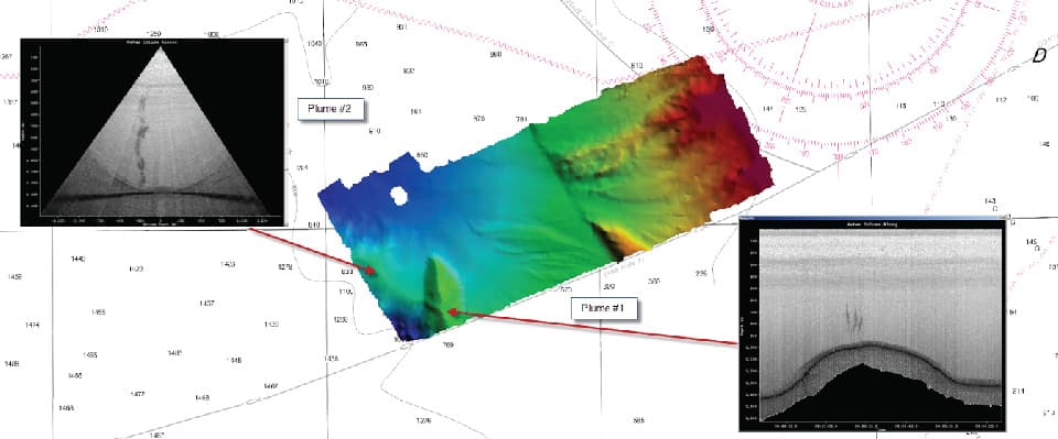
Mapping fault lines and mud volcanoes while updating nautical charts.
In 2017, NOAA Ship Fairweather surveyed a portion of the Queen Charlotte-Fairweather fault system on the U.S.-Canadian border.
The ship surveyed an area west of the Dixon Entrance, a Pacific strait located between Alaska and British Columbia.
The survey, done at the request of the U.S.
Geological Survey and California State University, supported earthquake, tsunami, and storm surge readiness for coastal communities in the region.
The Fairweather characterized both the sea floor and the water column using its mulitbeam echo sounder.
The detailed images show the main fault line as well as a mud volcano and associated gases emitting from the sea floor.
Side scan sonar images of the Dixon Entrance mud volcano and associated plume of gases with location shown on a map generated from multibeam echo sounder bathymetric data.
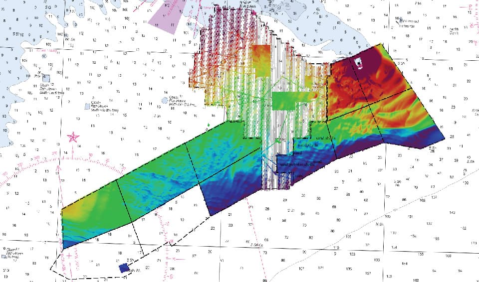
Mapping essential fish habitat while updating nautical charts.
In 2016, NOAA’s Office of Coast Survey and the National Centers for Coastal Ocean Science (NCCOS) collaborated to map the continental shelf near Wilmington, North Carolina, for navigation safety and habitat analysis to support ecosystem management and ocean planning.
Past habitat surveys conducted by NCCOS were refined for charting.
Scientists from Coast Survey, NCCOS, and the University of New Hampshire’s Center for Coastal and Ocean Mapping/Joint Hydrographic Center (UNH CCOM/JHC) refined best practices for the multi-objective mission.
The researchers tested a bottom camera attached to a grab sampler prototype developed by UNH CCOM/JHC scientists.
Bottom photos, sediment samples, backscatter, and bathymetry were collected to meet both habitat analysis and charting needs.
The project opened discussions on how scientists can best collect data that meets multiple needs, and how sea-floor imagery can best be served to stakeholders.
Integrated image of bathymetric and backscatter data of approaches to Wilmington, North Carolina.
Of the 900 square nautical miles that the chart updated.
570 square nautical miles will yield new habitat data.
Mapping offshore canyon habitats while updating nautical charts.
In 2016, NOAA Ship Rainier surveyed the offshore areas of Olympic Coast National Marine Sanctuary as part of a project to better understand the bathymetry and habitats of Washington’s submarine canyons.
The ship’s multibeam echo sounders collected swath bathymetry to update nautical charts while also collecting acoustic backscatter and water column data in support of coastal management efforts.
Backscatter data collected by NOAA Ship Rainier in 2016-2017 in Olympic Coast National Marine Sanctuary.
Five hundred kilometers off the coast of Ecuador, the American Eagle, a purse seiner, meets a refrigerated cargo ship.
The two ships drift slowly together in the tropical water for eight hours.
Encounters like this are common practice, allowing ships on long fishing voyages to refuel and transfer their catch—likely what the two ships were doing.
But the practice, called transshipment, can also disguise nefarious acts, such as smuggling illegally caught fish or even human trafficking.
In the Indian Ocean, off the remote Saya de Malha bank, the refrigerated cargo vessel (reefer) Leelawadee was seen with two unidentified likely fishing vessels tied alongside.
Ship to ship transfers can be made quickly and covertly on the high seas, leaving law enforcement officials unaware of the passage of illegal cargo in this watery Wild West.
And it’s no small problem: a 2014 study found that up to a third of wild-caught seafood sold in the United States was harvested illegally.
To combat this shadowy business, Global Fishing Watch, is monitoring the world’s fishing fleets by satellites, hoping to cast light on the dark places beyond national borders.
Global Fishing Watch uses Google Cloud technology to publish fishing efforts around the globe using machine learning. Everyone can help to observe fishing vessel operators which might practice illegal activity from The Global Fishing Watch map. With Indonesian Government, Global Fishing Watch overlaps Indonesian Fishing Activity Layer with Global Fishing Activity Layer, which enrich our views and analysis on fishing activities inside and outside Indonesian water.
Global Fishing Watch monitors the positions of boats by tracking the broadcasts from their onboard automated identification system (AIS) transponders.
All passenger ships and vessels larger than 300 gross tonnage are required by the International Maritime Organization to transmit their position.
The system’s main purpose is to reduce the likelihood of collisions between ships, but Global Fishing Watch analysts found they can follow a vessel, decipher its fishing activity, and see where it meets other ships.
The Hai Feng 648 is with an unidentified fishing vessel off the coast of Argentina.
There is a large mostly Chinese squid fleet just beyond the EEZ boundary.
The Hai Feng 648 was previously with the squid fleet at the edge of the Peruvian EEZ and in 2014 took illegally processed catch from the Lafayette into port in Peru.
With data from AIS and other satellite tracking systems, the team has created a global map of transshipping activity.
They’ve found that ships cluster outside the boundaries of exclusive economic zones—areas where marine resources are regulated—raising suspicions that the transshipments are associated with illegal fishing.
From 2012 to 2016 researchers identified 5,000 likely cases of transshipment—meetings between fishing vessels and reefers.
They also found an additional 86,000 cases where two reefers met at sea, which may also indicate smuggling.
Despite the extensive vessel tracking, the team can’t say for sure what ships like the American Eagle are up to.
“We may be talking about the issue of transshipment, but what we’re detecting really are what we call vessel rendezvous,” says Nathan Miller, a data scientist with Global Fishing Watch.
“These are two vessels that get close to each other and potentially meet. We don’t even know if they actually meet—all we can detect is they get very, very close together for an extended period of time.”
The best they can do, says Bjorn Bergman, a data analyst with the project, is provide the data for authorities to dig into further.
Recently, Global Fishing Watch data was passed to Ecuadorian authorities looking into the transportation of an illegal shark catch near the Galapagos Islands.
“The high seas present a big challenge because that’s where most of the slavery and much of the illegal fishing is, so [Global Fishing Watch] is fantastic to have,” says Daniel Pauly, a fisheries scientist at the University of British Columbia.
“This gives additional weapons to hard-pressed authorities in various countries.”
All of Global Fishing Watch’s data is publicly available on their website, where it’s posted just days after the signals are received.
Automated notifications available through the website can help port authorities, marine conservationists, and other interested parties monitor specific regions for suspicious behavior.
The data is also valuable to companies that want to tell consumers where their seafood comes from.
“Everything that we’re doing … is really about transparency,” says Miller.
“That’s going to be the way in which positive change happens.”
Researchers at the Johns Hopkins University Applied Physics Laboratory in Laurel, Maryland, have developed an innovative unmanned aerial vehicle (UAV) that can stay on station beneath the water, then launch into the air to perform a variety of missions.
Marine scientists and sanctuary managers are grappling with how to contain a growing nuisance – which could harm whales, seals and other marine mammals – while ensuring scientists can continue using drones for valuable research.
The airborne invaders began showing up in 2013.
In one of the earliest instances, two guys with two drones flying in tandem made multiple passes over a herd of pregnant harbor seals below Hopkins Marine Station at the southern end of Monterey Bay off the coast of California.
Scared, the seals stampeded into the water.
Scolded by passersby on the trail above the beach, the drone operators said they could do whatever they wanted.
But they can’t, not legally anyway.
The Marine Mammal Protection Act prohibits disturbing marine mammals, even common ones like harbor seals.
And Monterey Bay National Marine Sanctuary, which spans the offshore waters and shoreline from north of San Francisco to nearly 300 miles (480km) south, has had regulations banning low-flying aircraft of any kind since 1992.
Following Snotbot's team of researchers on their Sea of Cortez expedition, a groundbreaking initiative to adapt cutting edge aerial technology for the purpose of whale research and conservation.
As the casual and professional use of drones increases, the marine sanctuary is just one of the places where concerns are being raised about whether the unmanned devices are hurting ocean wildlife – and whether new regulations or better education and enforcement of existing laws are needed.
Regulations against disturbing wildlife “apply whether you’re in a kayak, flying a drone, in a helicopter – it doesn’t really matter,” said Scott Kathey, the sanctuary’s federal regulatory coordinator.
Enforcement officers haven’t issued fines yet, he said, but have given several written warnings.
Those warnings are because drones – or any noisy or strange disturbance – could stress animals to the point that they might not be able to feed or rest and could scare them into stampeding away in a panic, abandoning or injuring their young.
A 2015 study from the National Oceanographic and Atmospheric Administration (NOAA) showed that pinnipeds – seals, sea lions and walruses – are more sensitive to drone activity at low altitudes than cetaceans, which include whales, dolphins and porpoises.
However, even whales notice them, according to marine biologist Alicia Amerson, who has heard accounts of whales flipping over and looking up at hovering drones.
The NOAA study’s lead author, Courtney Smith, said new science has been published since the report came out, but “many data gaps remain” on how marine mammals respond to these noise disturbances.
Discovery Channel using drones to film “Shark Week” off the coast of northern Florida.
(Charles Ommanney for the Washington Post)
While efforts to understand more specifics are continuing, so are those to educate drone users – both about negative effects and about the rules that are in place.
Amerson, who is based in California, started a new initiative, AliMoSphere, earlier this year to develop best practice guidelines for using drones to study marine wildlife.
The group also conducts training sessions for anyone interested, at $20 per attendee.
She says sessions will be held throughout the winter on the West Coast as gray whales migrate south.
“Drones allow us to see things from different perspectives and everyone wants to show their friends and family a great wildlife shot,” said Brian Taggart, the director of Oceans Unmanned, which promotes the safe operation of drones and other autonomous technologies to protect the marine environment.
Taggart says resource managers have reached out to the group with increasing reports of disturbances, which led it, too, to create an education campaign, ECO-Drone.
They’re also working on developing a certification course.
Humpback Whales Feeding in Pristine Alaskan Waters
Researchers and commercial operators generally know the rules, Kathey said, but the new wave of drone hobbyists often don’t, and it’s on them to learn them.
“When you enter the state of Nevada, there isn’t a sign saying these are the rules of the road in Nevada.
If you’re entering the state, it’s your responsibility,” he said.
In the sanctuary, drones and any motorized aircraft are banned in four areas, and the Federal Aviation Administration (FAA) also has its own more general restrictions.
The sanctuary’s education strategy involves making sure all the rules are easily accessible and advertised, because placing signs every 20ft (6m) along the beach isn’t exactly practical, he said.
In many places, however, it may be unclear who is in charge or where to go to find more information, and so reaching hobbyists earlier might be better.
Kathey said the Greater Farallones National Marine Sanctuary to the north of the Monterey Bay sanctuary has been working with manufacturers on putting messaging on packaging and that there have been discussions about developing geofencing – basically digital borders – that would automatically notify drone users of local regulations within a specific area.
Drones and similar new technologies, meanwhile, have opened the door to myriad new research opportunities.
For scientists, who often will get permits to study protected wildlife, the problem is an old one: how to get close, now with a flying whirring device, without disrupting animals and how to observe without influencing animal behavior.
For example, Amerson flew drones about 130ft (40m) above humpback and right whales off Australia the past two summers to learn about their body conditions and prey availability.
The mothers don’t eat in the reproductive area off Australia, so by taking photos with drones she and her colleagues could try to track, essentially, how fast the mom is shrinking compared to how quickly their baby is fattening up.
Scientists, too, are learning best practices.
“One of the big challenges with this emerging technology is that each class and type of drone presents a different visual and acoustic profile, and each species of concern reacts differently to those factors,” Taggart said.
Collecting data on the disturbances, he said, needs to be a part of using drones in research.
In 2016, Institute of Marine Research (IMR) used a drone to count seals in southern Norway.
For example, Oceans Unmanned is using both fixed-wing and quad drones to count a gray seal population in New England this winter.
“It’s best to start high and work lower,” Taggart said, watching for any signs the animals feel harassed or disturbed.
“Every flight helps our understanding of any negative effects.”
NOAA says it is working closely with the marine mammal research community to create formal guidance and best practices for drone operators, which it expects to issue in 2018.
It is aiming to reconcile the FAA’s rule requiring drones to stay below 400ft (120m) with its own rules requiring any aircraft, including drones, to not fly lower than 1,500ft (460m) in sensitive areas.
Drone regulations could help prevent wildlife harassment, Taggart said, but so too could improving technologies, including the cameras themselves.
With better cameras, drone operators may not need to get so close to wildlife in the first place.
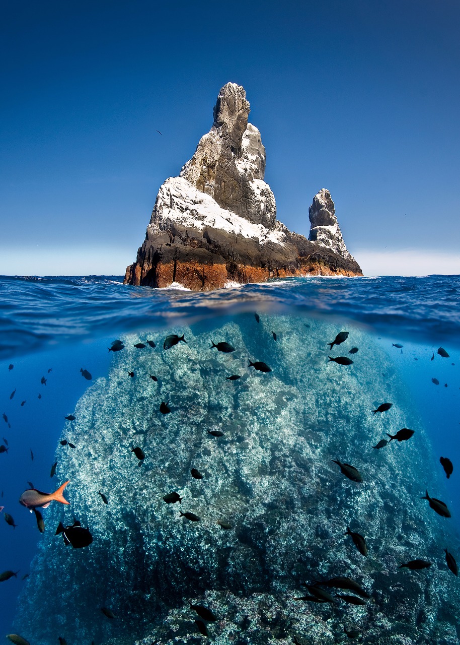
Fishing, mining and new hotels will be prohibited in the ‘biologically spectacular’ Revillagigedo archipelago
Mexico’s government has created the largest ocean reserve in North America around a Pacific archipelago regarded as its crown jewel.
The measures will help ensure the conservation of marine creatures including whales, giant rays and turtles.
The protection zone spans 57,000 sq miles (150,000 sq km) around the Revillagigedo islands, which lie 242 miles (390 km) south-west of the Baja California peninsula.
Mexico’s president, Enrique Peña Nieto, announced the decision in a decree that also bans mining and the construction of new hotels on the islands.
He said on Saturday that the decree reaffirmed the country’s “commitment to the preservation of the heritage of Mexico and the world”.
The four volcanic islands that make up the Revillagigedo archipelago, called the Galapagos of North America, are part of a submerged volcanic mountain range.
The surrounding waters, east of Hawaii, are home to hundreds of species of animals and plants, including rays, humpback whales, sea turtles, lizards and migratory birds.
The Revillagigedo islands are home to almost 400 fish species, including bluefin trevally and leather bass. courtesy of gob.mx
The local ecosystem is central to the lives of some 400 species of fish, sharks and ray that depend on the nutrients drawn up by the ocean.
The area is a breeding ground for commercially fished species such as tuna and sierra.
However, the various fish populations had suffered, unable to reproduce fast enough for the rate at which they were fished.
Revillagigedo islands with the GeoGarage platform (NGA chart)
The creation of a marine reserve is expected to help them to recover, as all fishing activities will now be prohibited.
This will be policed by the Mexican navy.
The news has been praised by WWF, the conservation organisation.
Mario Gómez, executive director of Beta Diversidad, a Mexican environment charity that has supported the reserve’s creation, also welcomed the move.
“We are proud of the protection we will provide to marine life in this area, and for the preservation of this important centre of connectivity of species migrating throughout the Pacific,” Gómez said.
Matt Rand, director of the Pew Bertarelli ocean legacy project, told HuffPost that the reserve was “biologically spectacular” and commended the Mexican government.
“It wasn’t an easy decision because they had significant opposition from the commercial fishing industry, which I think is unfortunate,” Rand said.
“I would love to see a commercial industry embrace this notion that certain areas should be protected.”
The United Nations convention on biological diversity aims to protect 10% of the world’s oceans by 2020.
However, some experts argue that protecting 30% of the world’s oceans from exploitation and harm would be a more appropriate goal in the drive for a more sustainable planet.
Just 6% of the global ocean has been set aside as marine protected areas or been earmarked for future protection.
Mexico joins Chile, New Zealand and Tahiti in taking recent steps to preserve the ecological systems in their territorial waters.
Conversely, President Trump is considering shrinking two marine national monuments in the Pacific: Rose Atoll and the Pacific Remote Islands.
These would be opened to commercial fishing, along with the Northeast Canyons and Seamounts, off the coast of New England, the Washington Post has reported.


