under the hammer in Brussels on May 25th (lot 710) (Arenberg Auctions)
It is a first edition from 1662 and contains a total of eleven volumes.
These contain 592 hand-painted maps - plus over 3,000 pages with descriptions of the continents, regions and countries shown. The atlas was considered the most expensive book of its time.
The value of the issue offered by a private collector is estimated at 250,000 to 350,000 euros. According to Aarenberg, only twelve editions are known in public collections worldwide. see digital reproduction of the book
Working for the Dutch East India Company, Joan Blaeu produced a vast atlas with hundreds of baroque maps gracing thousands of pages.
"He's the last of a tradition: the single, brilliant, magician-like mapmaker who says, 'I can magically show you the entire world,'" Brotton, a professor of Renaissance studies at Queen Mary University of London says.
"By the late 17th century, with joint stock companies mapping every corner of the world, anonymous teams of people are crunching data and producing maps."
But he did break with a mapmaking tradition dating back to Ptolemy of placing the earth at the center of the universe.
At the top of the map, the sun is at the center of personifications of the five known planets at the time—in a nod to Copernicus's theory of the cosmos, even as the earth, divided into two hemispheres, remains at the center of the map, in deference to Ptolemy (Ptolemy is in the upper left, and Copernicus in the upper right).
"Blau quietly, cautiously says I think Copernicus is probably right," Brotton says.
Canada’s coasts support Indigenous and coastal communities, enable international trade, are home to precious ecosystems, and play a key role in strengthening the economy and growing our middle class.
The Government of Canada’s $1.5 billion Oceans Protection Plan—the largest investment ever made to protect our coasts and waterways—is building a world-leading marine safety system and will lead to cleaner and safer coasts.
Today, the Honourable Marc Garneau, Minister of Transport announced four measures to help protect Canada’s waters and coastlines as part of the Oceans Protection Plan.
These measures are:
Providing $110 million over five years for the Canadian Hydrographic Service to chart 23 high-priority commercial ports and near-shore areas along all three coasts to create safer navigation for mariners.
This new investment will fill important gaps in critical areas across the country that currently have limited and out-of-date navigational information, and give mariners high-resolution electronic navigation charts, navigational products and data for increased safety.
To date, surveys of eight out of the 23 ports have been completed.
Adding seven additional coastal communities (nine total) to test a new information system showing where ship traffic is located—and other essential maritime information—as part of the Enhanced Maritime Situational Awareness initiative.
The selection of a contractor to build a system that can provide near-real time data on local ship traffic will be one of the largest agile procurement projects in the Government of Canada’s history.
Indigenous and coastal communities, Transport Canada and the Canadian Coast Guard will work together to award the contract.
Through the $62.5 million invested in the Enhanced Maritime Situational Awareness initiative, the Government of Canada will make $9.8 million available over two years to support the implementation of these pilot project communities and work with them to develop, test and evaluate the new system.
Awarding an initial contract to Hercules SLR of Dartmouth, Nova Scotia, to supply the Canadian Coast Guard with two vessel-based emergency tow kits, plus equipment and training.
This initial contract is valued at more than $180,000, and is part of a plan to install tow kits and related equipment on all large Canadian Coast Guard vessels, including five vessels on the West Coast.
The initial contract includes options for up to 62 additional tow kits and related equipment.
Allocating $7.2 million over five years in the Marine Weather Information Services Demonstration Project.
This project will deploy five smart buoys (two on the west coast and three on the east coast) that will produce data for tailored weather forecasts.
These smart buoys will have innovative high resolution weather prediction systems that will enhance marine forecasting and improve marine navigation and safety for mariners.
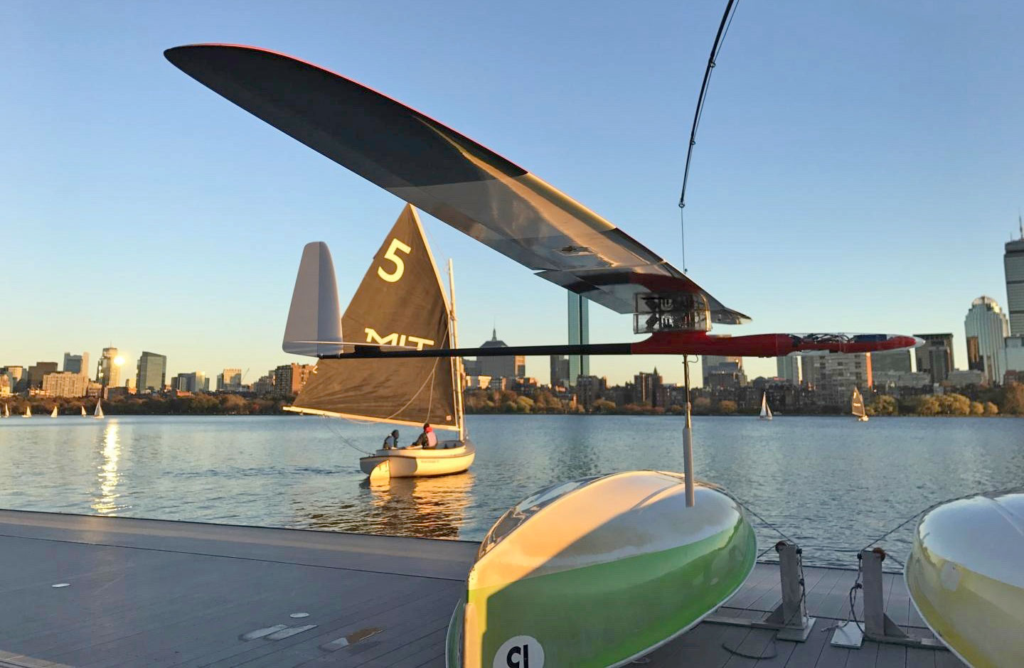
The work takes inspiration from the flight of the albatross to conceive an autonomous flying robot able to extract its energy from the winds of the ocean.
The ultimate motivation is that if energy is extracted from winds there is no need for refueling, so a robotic albatross could survey and study the oceans for weeks or months at a time, traveling tens of thousands of kilometers in a single mission.
In an effort to better monitor the world’s oceans, a team from MIT has built a super-efficient glider, similar in design to an albatross.
The vastness of the world’s oceans makes it incredibly difficult for anyone to effectively monitor a large body of water, and while satellites have certainly helped, we have yet to find an effective Earth-based solution.
But now, a team from MIT has unveiled its latest creation based on the gliding power of the common seabird known as the albatross.
Engineers at MIT have developed a new model to simulate dynamic soaring, and have used it to identify the optimal flight pattern that an albatross should take in order to harvest the most wind and energy.
They found that as an albatross banks or turns, it should do so in shallow arcs, keeping almost to a straight, forward trajectory.
The first aspect of the research, the
“model reduction step”, consists in deconstructing the physics of the
albatross’ flight (called “dynamic soaring” in the field) in order to
extract fundamental and general laws. -see article on dynamic soaring-
This
step, which involves physical and mathematical analysis, flight
dynamics, aerodynamics, geophysical fluid dynamics, and trajectory
optimization, aims at identifying which aspects of the problem matter
and which don’t, in order to generate a simple model of predictive
power.
Model reduction is
important when designing innovative systems, because often the design
space is not well understood and very large; it is also helpful in
numerous flavors of machine learning.
The autonomous glider is capable of skimming along the water’s surface in a glide similar to an albatross and is also capable of riding the waves like a sailboat.
The second aspect of my research,
the “design and demonstration step” is about adapting the lessons learnt
from the model reduction step in order to imagine and demonstrate a
robot that combines the solutions found by biological systems with the
capabilities of man-made systems.
More
precisely, I propose a general framework for a bioinspired robot,
characterize the design space and provide the underlying science and
engineering for further developments.
I then demonstrate the most innovative and critical aspects of the system with a prototype.
This
involves the design, fabrication/implementation and test of mechanical
systems (the robot and test environment), electrical systems (sensors,
actuators and communication), the embedded software (estimation and
control algorithms), and their integration. -Photo: Gabriel Bousquet-
‘The oceans remain vastly under monitored’
When dropped into a region of high wind, it is designed to stay aloft, and when the winds are calmer can become a sea-faring vessel.
Borrowing from both nautical and biological designs, the craft can cover a determined distance using one-third as much wind as an albatross, while travelling 10 times faster than a typical sailboat can as it weighs just under 3kg.
“The oceans remain vastly under monitored,” said Gabriel Bousquet who led the design of the robot as part of his graduate thesis.
“In particular, it’s very important to understand the Southern Ocean and how it is interacting with climate change. But it’s very hard to get there. We can now use the energy from the environment in an efficient way to do this long-distance travel, with a system that remains small-scale.”
An albatross glider skims the Charles River.
Roaming in packs
The design came about last year after Bousquet and a number of other researchers looked into the dynamics of albatross flight to better understand how the bird could travel huge distances without exerting enormous amounts of energy.
The team found that the physics of the bird’s flight is very similar to that of sailboat travel as they both transfer momentum in order to keep moving.
In terms of speed, the craft should only need relatively calm winds of about five knots to zip across waters at a velocity of about 20 knots, equal to around 37kph.
Once the design was agreed upon, it was then a matter of adding the hardware which includes GPS, inertial measurement sensors, auto-pilot instrumentation and ultrasound to track the height of the glider above the water.
The team’s goal is to one day have a design which will allow for packs of these speedy skimmers to be deployed to cover huge areas of an ocean.
AECO’s (The Association of Expedition Cruise Operations) push to speed up the chartering in eastern and south Svalbard has given results, the group said in a press release.
AECO’s (The Association of Expedition Cruise Operations) push to speed up mapping in eastern and south Svalbard has given results, the group said in a press release.
Svalbard islands with the GeoGarage platform (NHS chart)
A shipping lane through Storfjorden, including a lane along the coast of Edgeøya has been added as a new chart.
New nautical charts, no. 528 (Storfjorden. Sør. Isbukta – Kvalpynten) and no. 532 (Storfjorden. Kvalpynten – Agardhbukta), and a new edition of no. 533 (Storfjorden Nord. Freemansundet – Heleysundet – Sørporten), will be issued on May 9.
The previous edition of chart no. 533 is from now invalid.
Chart no. 528, 532 and 533 are in scale 1:100 000, but chart 533 has two special editions: Ormholet in scale 1:20 000 and Heleysundet 1:50 000.
The width of the chartered corridors are 2,5 nautical miles/5 km.
In addition to the above, the Norwegian Mapping Authorities has also charted a corridor around Sørkapp.
The nautical chart, no. 527, is expected later this summer, AECO said.
These new charts are a result of dialogue and cooperation between AECO, the Norwegian Mapping Authority and the Norwegian Coastal Administration.
AECO invited the mentioned authorities to dialogue meetings with the objective to speed up the charting (and nautical chart production) in cruise industry prioritized areas, including shipping lanes in Storfjorden and around Sørkapp.
What if a country didn't end at the coastline but would simply continue under water?
A territory the size of a continent would come up - a territory uncontrolled and open for seizure. But who owns the sea bed, is it territory still to be claimed?
The fact that the world's oceans cover three-quarters of the earth's surface once meant very little to governments around the world.
This changed when water exploration teamed with demand for specific resources and the need for power.
Map showing the complete trajectory of the journey of the research vessel Meteor
during the German Atlantic Expedition from 16 April 1925 to 2 June 1927 (from Spieß , 1928).
The first scientific study of the ocean floor was undertaken by German survey vessel Meteor, which saw it conduct research on the Atlantic Ocean between 1925 and 1927.
The information uncovered about the ocean bed changed how nations viewed their once complacent takes on the importance of the ocean - politically and otherwise.
In 1945, spurred on by a demand for oil that could not be met by land resources, US President Harry Truman pioneered the idea of owning oceans by promoting the theory of extended continental shelf of submerged landmass - claiming a continent did not end at the shoreline but ownership by a nation extended into the ocean.
Prior to this, countries could only lay claim to the land extending 22 nautical miles (22km) from land's end.
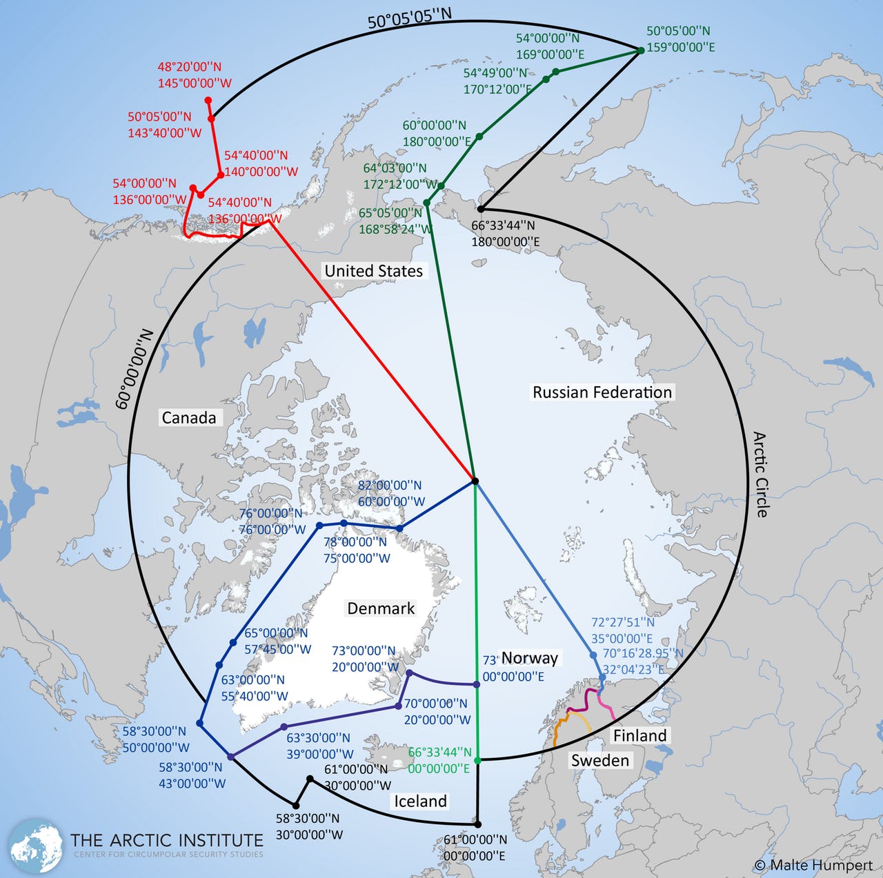
Arctic Council Search and Rescue Agreement, 2011
Using the theory of 'continental drift' - the belief that the continents' movement in relation to each other did so across ocean beds - and the 'legitimate' nature of science as evidence to prove his point, Truman's idea was systemised under the Outer Continental Shelf Lands Act of 1953, starting a war of laws.
How fair mother nature had been to landlocked nations was another issue to contend with.
"For instance, Russia has a wide [continental] shelf of more than 200 nautical miles, or over 400km. By contrast, South East Africa has a continental edge of only 20km. These features are the result of geological evolution. Some countries are lucky. Others are not," says geophysicist Wilfried Jokat.
Over 40 percent of the world's oceans have already been assigned to legal continental shelves, i.e. a land mass extended from the continent itself to the continental margin which is between the shoreline and the shelf break (where land slopes further into the water).
Claims on expanded geological continental shelves make up another 10 percent of the ocean - a process riddled with loopholes, allowing countries.
It is now projected that around 57 percent of the oceans will eventually be under the control of coastal states.
As new discoveries of oil and gas continue to further nations' desires to claim their own piece of the ocean bed, geologists have been propelled into the role of decision-makers, proving - or nullifying - claims to these desired areas.
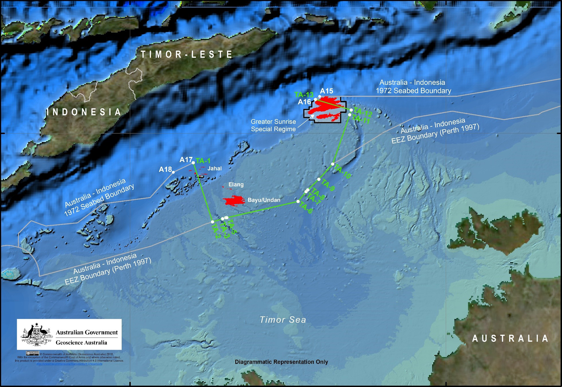
The new maritime boundary between Australia and Timor Leste.
The objectivity of the scientists involved in these processes has also come into question, with economic and strategic gains at stake.
"Science is decisive for expanding the continental shelf, because all the petitions are based on science. Geological data, seismic data, scientific studies. Everything depends on this information," says head of the French maritime law commission, Elie Jarmache.
"You can't go to the Commission on the Limits of the Continental Shelf and say, 'I am a member of the Security Council and want to expand my country's continental shelf.' That's not how it works. Politics has no place here."
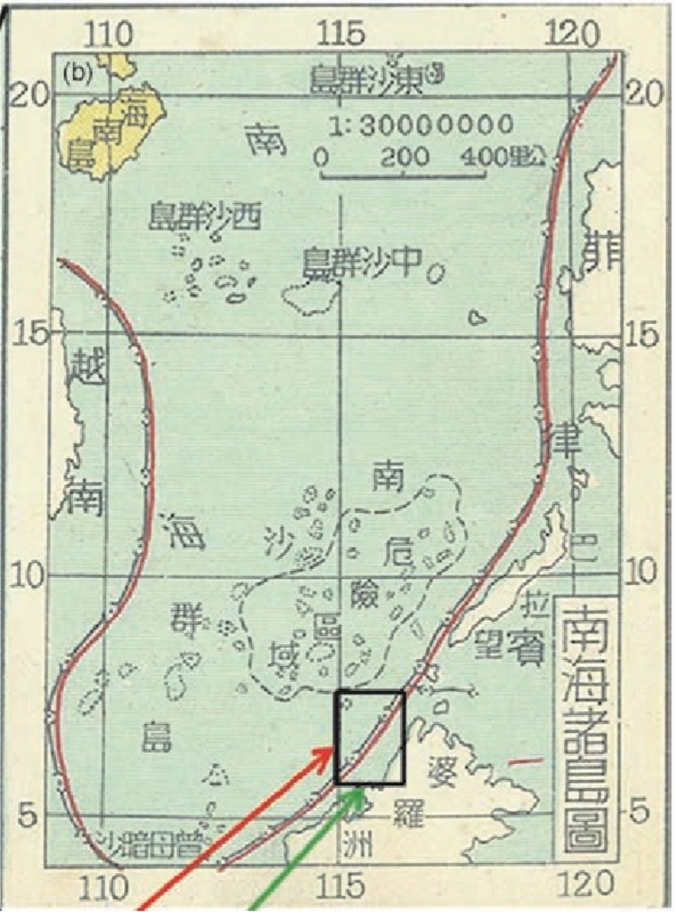
In 1951, an official map approved by the central government of China marked the China-claimed area in the South China Sea with a pair of non-stopping lines.
There was an inner black line indicating the sovereign boundary and an outer red line representing where China could exercise administrative power.
As states attempt to extend their maritime zones as far as possible, many international conflicts have arisen.
In the South China Sea, eight countries are fighting for oil reserves valued at $100 billion.
"There is no part of the world that is safer than any other," says Robert van de Poll, a maritime law expert. "
In other words, with 53 percent of all maritime boundaries within the Exclusive Economic Zone unresolved, we are seeing conflicts rising to volatile levels driven predominantly by resource development for the offshore."
Researchers often can’t afford to send remotely operated vehicles to the far reaches of the ocean.
Now they’re collaborating with business to take advantage of discoveries made by ROVs deployed by oil and gas companies.
A cusk eel hides under a black coral for hours, emerging for only a minute at a time before returning to its den.
A hammerhead shark skims the ocean floor more than 1,000m (3,400ft) beneath the surface – the deepest observation of the species ever recorded.
These are just two of the remarkable discoveries made by remotely operated vehicles (ROVs) deployed by the Shell Oil Group’s drillship Deepsea Metro 1 in the western Indian Ocean, off the coast of Tanzania.
Images from the ROVs have ended up in peer-reviewed scientific journals in recent years.
Now researchers from Australia, the United Kingdom and the United States, drawing on the knowledge of ROV operators delivered at a workshop last year in Perth, Australia, have outlined scientific research priorities that can be addressed using industry-owned machines, in a new study published in the journal Science of the Total Environment
“The paper was a chance for us as a team to think about what we’d discovered and what we could be discovering in the future,” said Peter Macreadie, associate professor of environmental science at Deakin University in Australia and lead author of the study.
“In the past it’s been ad hoc, but this was about coming together in a more strategic way.”
Oil and gas companies, for instance, fly ROVs up and down the water column as part of their routine environmental compliance requirements, as well as to explore for new resources.
That enables them to see things scientists can only dream of, given the cost of deploying ROVs.
Around 2000, deep-sea biologists and other marine scientists at the National Oceanography Centre (NOC) in the U.K.
were seeking a greater understanding of the biodiversity in the surrounding seas and initiated a consortium with industry.
The initial surveys conducted by the group, said NOC research scientist Daniel Jones, “revealed there were a lot of species that hadn’t been described.” Scientists sought to expand their access to industry ROVs, which was a new technology at the time.
This led to the formation of the Scientific and Environmental ROV Partnership Using Existing Industrial Technology, or SERPENT.
Sponge, black coral and cusk-eels
(SERPENT project)
It’s now run out of the NOC with partners at four Australian universities and Louisiana State University.
ROV operators deliver unexpected images of deep-sea life to SERPENT, and scientists visit remote drilling rigs and exploration vessels to conduct experiments.
Industry ROV operators in particular have been enthusiastic about providing scientists with the exceptional photos and video they capture.
“Spending time operating these ROVs out in the ocean, it’s a bit of a lonely existence,” Macreadie said.
“So to have scientists saying, ‘Whoa! What’s that?’ and ‘This is amazing!’ – I think it changes their sense of purpose in their role.”
The oil and gas industry isn’t in the business of making scientific discoveries, of course, but it has a financial incentive to participate in SERPENT and possible future research missions outlined in Macreadie’s paper.
Many oil and gas structures around the world – 4,000 in the Gulf of Mexico alone, according to Macreadie – are due for decommissioning in the next couple of decades.
But ecosystems rich with marine life have grown up around the oil rigs and some conservationists are wondering whether it might be better at this point to leave them in place.
That would save oil companies billions of dollars in removal and remediation costs.
(Some have proposed that a portion of the industry’s savings be devoted to programs to enhance the marine environment.)
The workshop Macreadie’s paper grew out of began as a discussion between scientists and rig operators about this “rigs-to-reefs” concept.
“But the meeting got a little bit hijacked,” he said, by the idea of outlining opportunities for scientific collaboration with industry.
Researchers told the group what they’d like to know about the deep-sea environment.
“Then ROV operators would provide us with a realistic perspective on what could be achievable,” Macreadie said.
A Robotics-As-A-Service business around operating Aquanaut for tasks that are currently performed by ROVs attached to vessels and drilling platforms
The paper described 10 questions that could be answered in part with ROVs.
These include questions about animal behavior in deep-water environments, the distribution and ranges of ocean organisms, the physical and biological processes of the deep ocean, how the ocean is changing, which marine ecosystems are most sensitive to human impact and the degree to which industrial infrastructure such as oil rigs enhance ecosystems.
Most ocean scientists, it’s safe to say, are opposed to new oil and gas development, both due to its climate impact and the potential for environmental disaster, such as the 2010 explosion of the Deepwater Horizon in the Gulf of Mexico.
But that doesn’t mean existing operations shouldn’t be leveraged for scientific discovery, Macreadie said.
“If we had to miss out on that data for the sake of avoiding oil and gas extraction already happening, I think most would sign on to that,” he said.
“But we’re being opportunistic.
It’s happening anyway, so let’s make the most of it.
If they’re doing exploration, we might as well turn it into positive for us.”
On 15 August 2011, an ROV operated by Mako Technologies working for
Hornbeck Offshore Services was conducting seafloor and water column
biotic surveys as part of the Deepwater Horizon oil spill NRDA.
The ROV was being recovered to the vessel when a single Orafish (Regalecus glesne)
was observed at a depth of 62 m.
Nevertheless, challenges remain.
Victoria Todd, managing director of U.K.-based Ocean Science Consulting, which conducts marine mammal surveys and monitoring for industry, has found that, SERPENTnotwithstanding, “it’s really difficult to get the information flowing between academics and industry, and I think that’s where the problem lies.”
Oil and gas representatives in particular “are naturally wary of having their data in the hands of academics” and are “mostly focused on ticking a box for environmental compliance and watching their profit margins,” she said, which makes her skeptical that valuable discoveries made by industry won’t just get “buried.”
But as a reviewer of Macreadie’s paper, she has hope for the future.
“It’s a great paper and maybe there will be the odd person in industry who will read it,” she said.
All but one of the 239 people on the doomed Malaysia Airlines Flight 370 had probably been unconscious — incapacitated by the sudden depressurization of the Boeing 777 — and had no way of knowing they were on an hours-long, meandering path to their deaths.
Along that path, a panel of aviation experts said Sunday, was a brief but telling detour near Penang, Malaysia, the home town of Captain Zaharie Ahmad Shah.
On two occasions, whoever was in control of the plane — and was probably the only one awake — tipped the craft to the left.
The experts believe Zaharie, the plane's pilot, was taking a final look.
That is the chilling theory that the team of analysts assembled by Australia's “60 Minutes” have posited about the final hours of MH370.
They suspect that the plane's 2014 disappearance and apparent crash were a suicide by the 53-year-0ld Zaharie — and a premeditated act of mass murder.
But first, the experts said, they believe that Zaharie depressurized the plane, knocking out anyone aboard who wasn't wearing an oxygen mask.
That would explain the silence from the plane as it veered wildly off course: no mayday from the craft's radio, no final goodbye texts, no attempted emergency calls that failed to connect.
That would also explain how whoever was in control had time to maneuver the plane to its final location.
Video prepared by Ocean Infinity for the commemoration event held in Kuala Lumpur on 3rd March 2018 on the occasion of the fourth anniversary of MH370’s disappearance.
The wreckage has not been found, though hundreds of millions of dollars have gone into the four-year search.
The secret of what happened in the final moments of the ill-fated flight — and the motive behind it all — probably died with its passengers and pilot.
But the “60 Minutes” team — which included aviation specialists, the former Australian Transport Safety Bureau chief in charge of investigating MH370's crash and an oceanographer — put forth what they believe is the most likely theory.
“The thing that gets discussed the most is that at the point where the pilot turned the transponder off, that he depressurized the airplane, which would disable the passengers,” said Larry Vance, a veteran aircraft investigator from Canada.
“He was killing himself. Unfortunately, he was killing everyone else onboard. And he did it deliberately.”
Zaharie's suspected suicide might explain an oddity about the plane's final flight path: that unexpected turn to the left.
“Captain Zaharie dipped his wing to see Penang, his home town,” Simon Hardy, a Boeing 777 senior pilot and instructor, said on “60 Minutes.”
“If you look very carefully, you can see it's actually a turn to the left, and then start a long turn to the right. And then [he does] another left turn. So I spent a long time thinking about what this could be, what technical reason is there for this, and, after two months, three months thinking about this, I finally got the answer: Someone was looking out the window.”
“It might be a long, emotional goodbye,” Hardy added. “Or a short, emotional goodbye to his home town.”
This presentation covers the technical accomplishments undertaken from a geospatial support perspective to support the search for MH370.
Geospatial support embedded within ATSB over the last 3 years included visualization of project data, creation of search areas, data management, statistical analysis and quality review of data collected.
With over 157 TB of data acquired throughout the search the Operational Search for MH370 has become the largest search of survey of its kind ever.
Flight 370 disappeared March 8, 2014, shortly after leaving Kuala Lumpur, bound for Beijing.
The craft is thought to have crashed in the far southern Indian Ocean.
The governments of Malaysia, China and Australia called off the official search in January 2017.
The Australian Transport Safety Bureau's final report said authorities were no closer to knowing the reasons for the plane’s disappearance or the exact location of its wreckage.
But the “60 Minutes” experts tried to answer one of the biggest questions surrounding the flight:
How could a modern aircraft tracked by radar and satellites simply disappear?
Because, they say, Zaharie wanted it to.
And the veteran pilot, who had nearly 20,000 hours of flight experience and had built a flight simulator in his home, knew exactly how to do it.
For example, at one point, he flew near the border of Malaysia and Thailand, crisscrossing into the airspace of both, Hardy said.
But neither country was likely to see the plane as a threat because it was on the edge of their airspace.
Because, they say, Zaharie wanted it to. And the veteran pilot, who had nearly 20,000 hours of flight experience and had built a flight simulator in his home, knew exactly how to do it.
For example, at one point, he flew near the border of Malaysia and Thailand, crisscrossing into the airspace of both, Hardy said.
But neither country was likely to see the plane as a threat because it was on the edge of their airspace.
Another theory was that he hijacked the plane in protest of the jailing of Anwar Ibrahim, who was then the opposition leader in Malaysia.
A group called the Chinese Martyrs' Brigade claimed responsibility for the downing, although skeptical officials called this a hoax.
Two men on the plane were flying with phony passports, but one was apparently an asylum seeker, and neither had terrorism links.
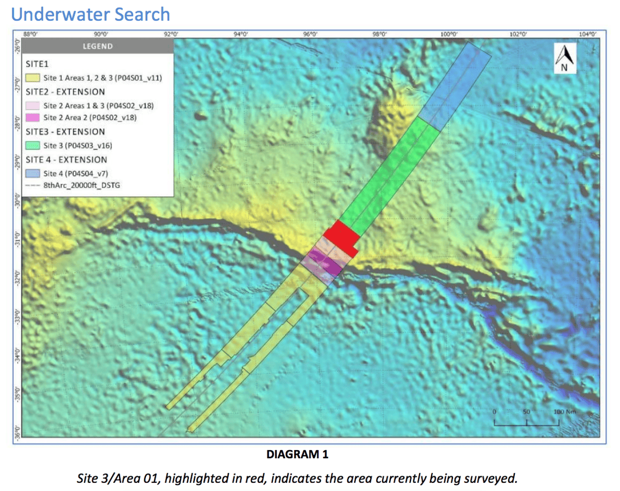
Current analysis places the most likely site of the MH370 fuselage close to the ‘seventh arc’, which shows possible locations of the plane at the time of the seventh detected radar ping.
Image supplied by Geoscience Australia.
The Site 4 extension is shown for the first time in this diagram from the 12th weekly report, released on 17 April.
Map of the underwater search area for MH370 conducted by Ocean Infinity and showing Site 4 - the new area added to the search.
The original search area of Sites 1,2 and 3 is shown on this diagram from the first week of the search (30 January). The area in yellow corresponds to the ATSB priority area.
Photographies: Malaysian government
The wreckage, of course, might provide some insight about what caused the airplane to crash, and crews were still looking for it as recently as this year.
The latest attempt to discover it was a $70 million effort by a Texas company called Ocean Infinity, according to the Associated Press.
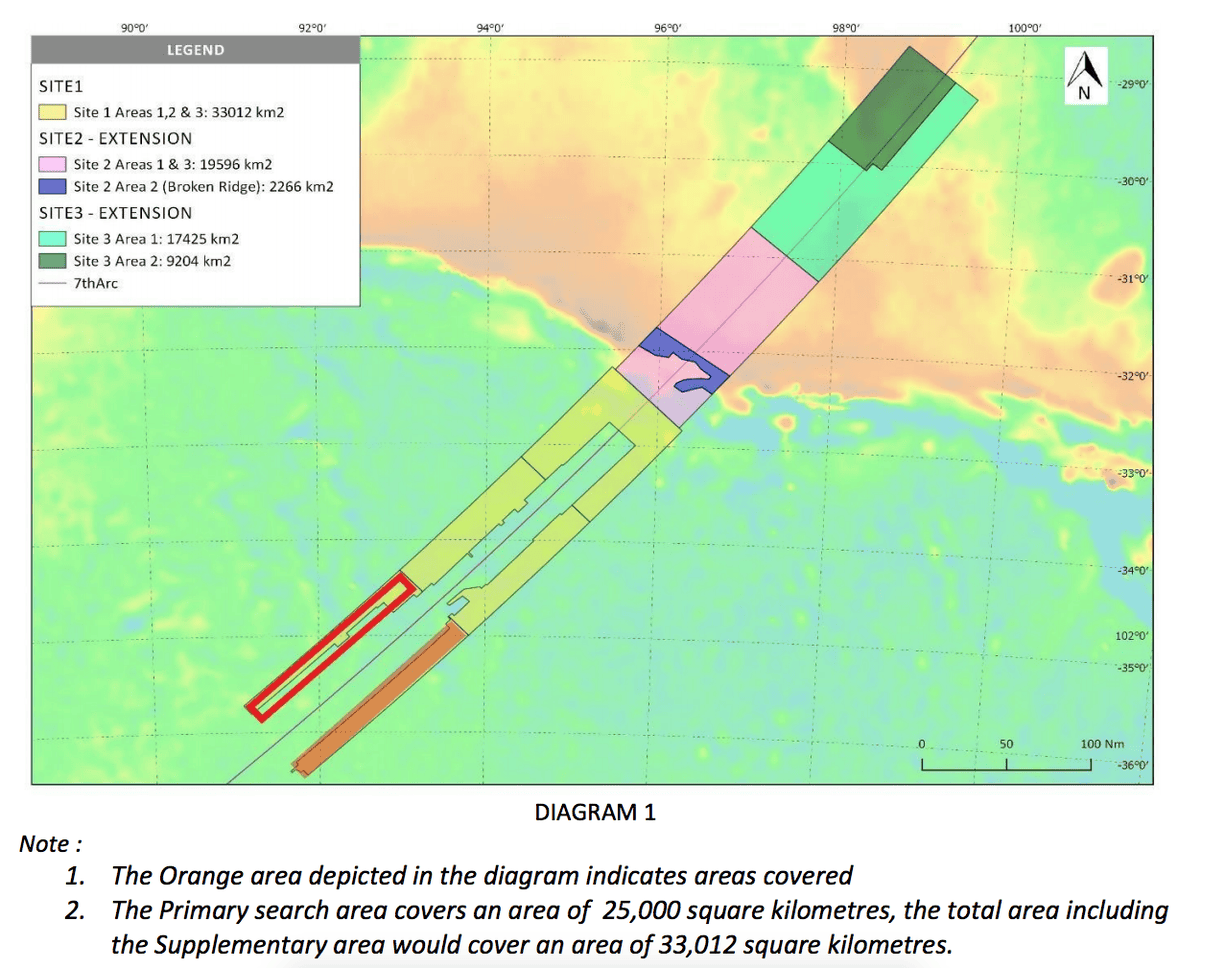
The mission scanned 500 square miles a day during a three-month search.
Ocean Infinity CEO Oliver Plunkett said the company's technology had performed “exceptionally well” and collected “significant amounts of high-quality data.”
Still, it found no trace of MH370.
At 78 feet tall, and churned by a fierce storm, it’s the largest wave ever recorded in the southern hemisphere, New Zealand scientists report.
“This is a very exciting event and to our knowledge it is largest wave ever recorded in the southern hemisphere,” said Tom Durrant, a senior oceanographer with MetOcean Solutions, in a statement. “So, this is a very important storm to capture, and it will add greatly to our understanding of the wave physics under extreme conditions in the Southern Ocean.”
An enormous ocean wave reaching 78.1 feet (23.8 meters) in height has
just hit Campbell Island.
The previous record-breaking wave in this region was recorded in 2012
when a wave was found to have reached 72.3 feet (22.03 meters) in
height in Tasmania.
The intense storm
that has lashed the Southern Ocean around New Zealand and Campbell
Island will soon be giving surfing enthusiasts in California powerful
waves of their own.
Campbell island with the GeoGarage platform (Linz chart)
The wave was recorded on the night of May 9 by a MetOcean buoy (Campbell island WRB (CIWRB) which is currently floating in the Southern Ocean near Campbell Island about 430 miles (692 km) south of New Zealand.
Campbell Island Wave Rider Buoy was moored on 2 March 2018 at Campbell Island
The wave reached a height of 78 feet (23.8 meters) as a storm rolled through the region.
The previous record, also recorded by MetOcean Solutions, was a 63.6-foot (19.4 meter) wave that rolled through the same patch of ocean last year.
Simulation of the storm : wind and Mean sea Level pressure (left) and significant wave height (right) passing over New Zealand
The wave was detected by a single solar powered buoy, which samples wave conditions for 20 minutes every three hours.
The intermittent sampling is done to conserve energy.
During the recording period, the height, period, and direction of each wave is measured, and the data is transmitted to a receiving satellite.
Oceanographers with MetOcean Solutions, a subsidiary of the state-owned Meteorological Service of New Zealand (MetService), believe the peak heights of waves were even higher during the storm. Their wave forecast predicted individual waves reaching heights of 82 feet (25 meters).
The Southern Ocean is one of the least-studied areas on Earth.
Its persistent and energetic winds make it an “engine room” for wave development, producing waves that traverse the globe, including the iconic surfing waves that reach the California coast.
The May 9 storm was generated by the easterly passage of a deep low-pressure system, and accompanied by winds reaching 65 knots (75 mph/120 km/h).
These low-pressure storms are typical in the Southern Ocean, and they can strike at any time of the year, unlike in the northern hemisphere where similar storms only happen in winter.
When measuring waves, oceanographers use a metric called “significant wave height.”
It’s a standard value that characterizes sea conditions, and it takes the average of the highest third of a measured wave.
The May 9 storm produced a significant wave height of 48.9 feet (14.9 meters), which is now a record for the Southern Ocean.
But it’s not the biggest ever recorded; that distinction goes to a 2013 North Atlantic wave with a significant wave height of 62 feet (19 meters).
According to the Smithsonian, the largest wave ever recorded was in Alaska’s Lituya Bay in 1958. It measured 30.5 meters (100 feet) and was caused due to a tsunami, which killed five people. The wave snapped 1,700 trees but did not damage much property as there were a very few towns nearby.
Koxa’s ride also broke a Guinness World Record for the biggest wave ever surfed. “I'm just so happy and this is the best day of my life,” Koxa said at the awards.
Previously, the record was set by Hawaii’s Garrett McNamara in 2011 with a 78-foot-tall wave off the same coast.
Other surfers have said they broke that 2011 record, but Koxa’s wave was confirmed—experts can measure a wave from trough to crest by comparing it with the size of the people surfing it.
In less extreme waters, surfers usually paddle up waves before standing up and riding them, but since Koxa’s 80-foot-tall roller is too fast, towing in on a jet ski allows him to get closer.
The jet ski releases him and in seconds, the powerful waters surge up to him.
Koxa barely manages to evade the wave as it rushes like an avalanche behind him.
Koxa is an experienced surfer and escaped unscathed—this time.
In 2014, he had a brush with death at the same beach.
The experience sent him into a four-month slump where he had nightmares, didn’t travel, and got scared easily.
It’s no coincidence that Koxa and Cotton both rode enormous waves at the same beach on the same day.
The beach’s location and geography make it prime territory and a magnet for intrepid surfers.
Although one surfer got away from the wave with a broken record, the other barely got away with a broken back.
The beach’s westerly location on the European coast allows it to catch wind, and thus ocean swells, from storms that sweep across the North Atlantic.
A deep canyon runs under the surf and points toward the town, which focuses the ocean swells directly toward the lighthouse at the edge of Nazaré. Nazaré Canyon, the underwater abyss, is 130 miles long and as deep as 16,000 feet below the ocean’s surface in some areas.
“The ocean swells get focused in this submarine canyon and have much more energy,” surfer and forecaster Micah Sklut told NPR in 2013.
“So, first you’ve got really deep water, and then as it approaches the shore it gets very shallow, and that enables the waves to climb really, really big all of a sudden.”
Nazaré’s undersea geography make it particularly unique, but it’s not the only place to catch a big wave.
.jpg)