Discover with us the rapid changes affecting the Arctic.
A few shots of our North Atlantic crossing. Unu Mondo expedition is a 5-month sailing expedition to the Arctic to understand and anticipate the impacts of global warming and provide concrete solutions.
Before departure, Tobias Carter, captain of the Expedition and Sophie Simonin, Expedition Director have prepared a video to show you the aluminum sailboat "Northabout", which is specially built for the Arctic.
We’ve been busy with preparations since February, flashback on these last eventful weeks! With just a few days to go, our team is more than motivated to set sail for Greenland...
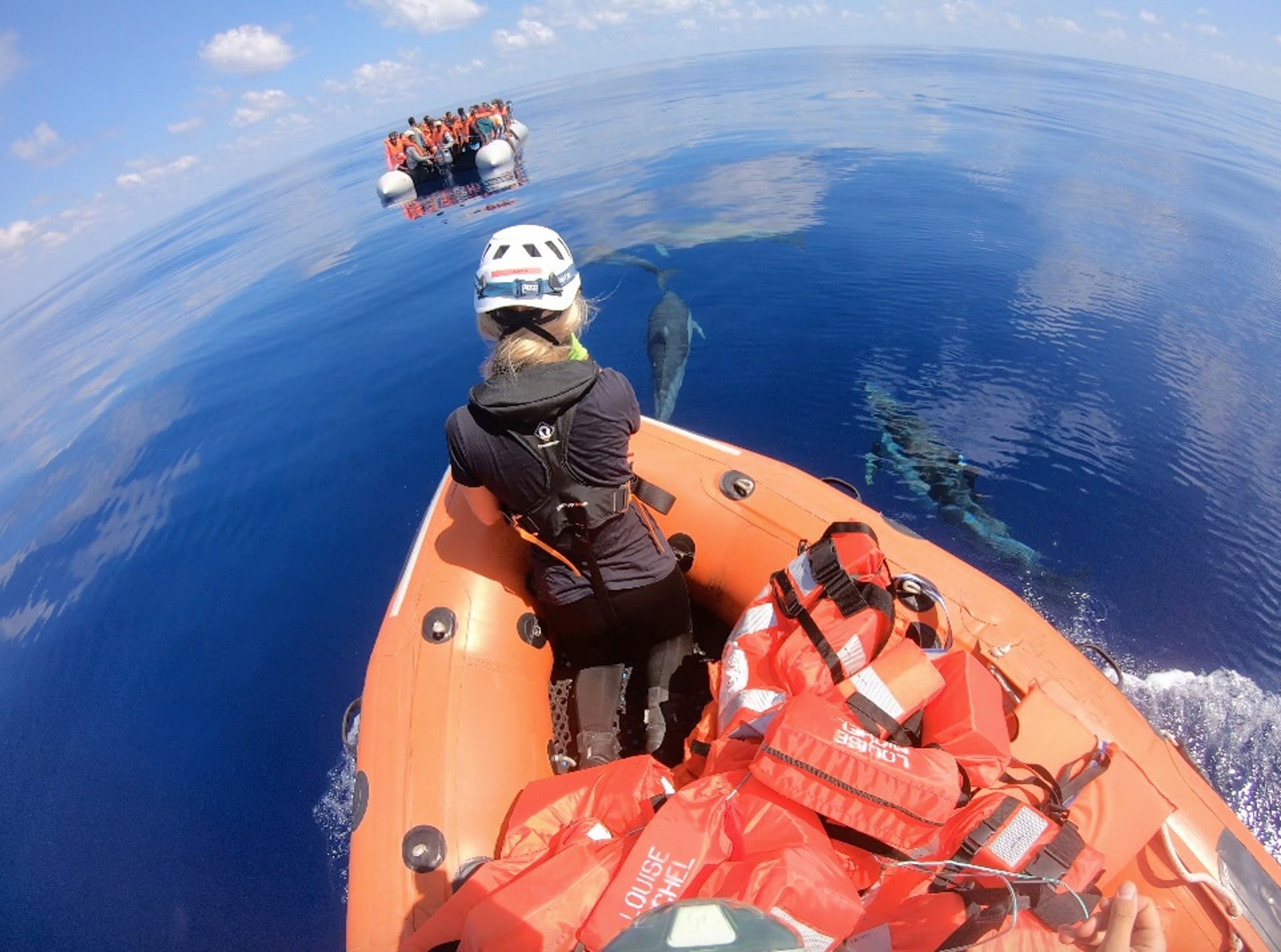
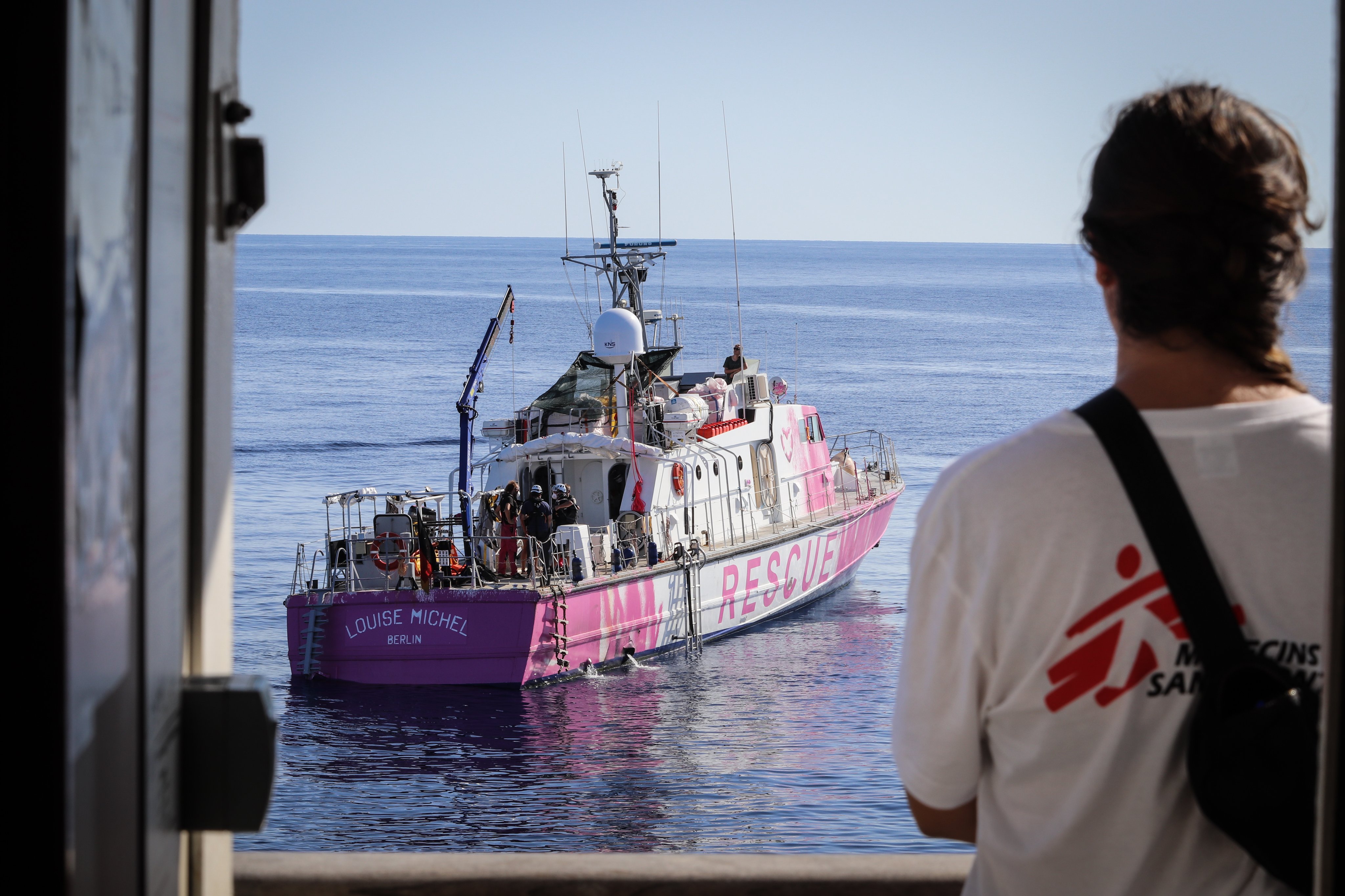
Spectacular photo of rescue carried by Banksy’s boat Crew
rescuing migrants in distress approached by dolphins off Libya’s coast
Photograph: Ruben Neugebauer
From The Guardian by Lorenzo Tndo and Maurice Stierl
Exclusive: UK artist finances bright pink motor yacht that set sail in secrecy to avoid being intercepted by authorities
The British street artist Banksy has financed a boat to rescue refugees attempting to reach Europe from north Africa, the Guardian can reveal.
The vessel, named Louise Michel after a French feminist anarchist, set off in secrecy on 18 August from the Spanish seaport of Burriana, near Valencia, and is now in the central Mediterranean where on Thursday it rescued 89 people in distress, including 14 women and four children.
It is now looking for a safe seaport to disembark the passengers or to transfer them to a European coastguard vessel.
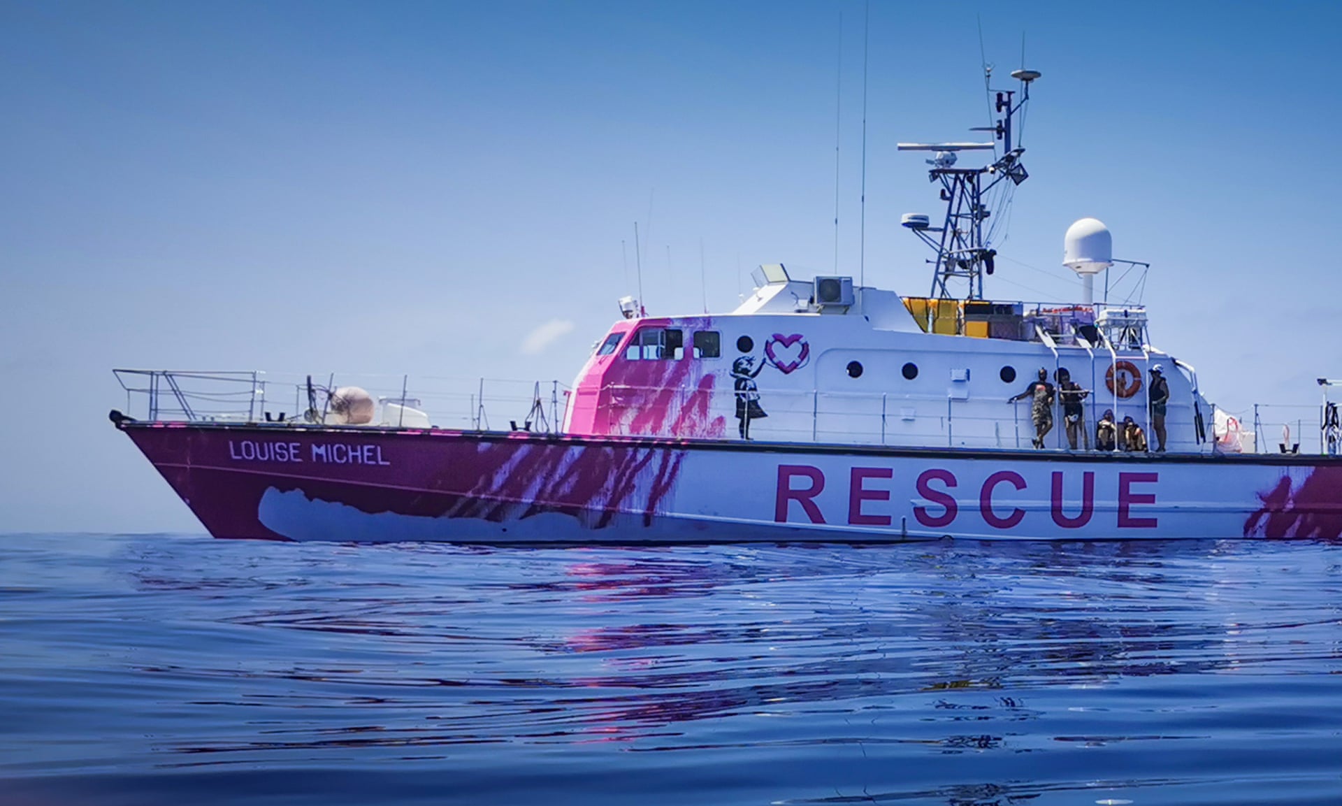
The Louise Michel ship that Banksy has financed. Banksy funds boat to save humans
Photograph: Ruben Neugebauer
The crew, made up of European activists with long experience in search and rescue operations, had already assisted in two other rescue operations involving a total of 105 people, who are now onboard the NGO vessel Sea-Watch 4.
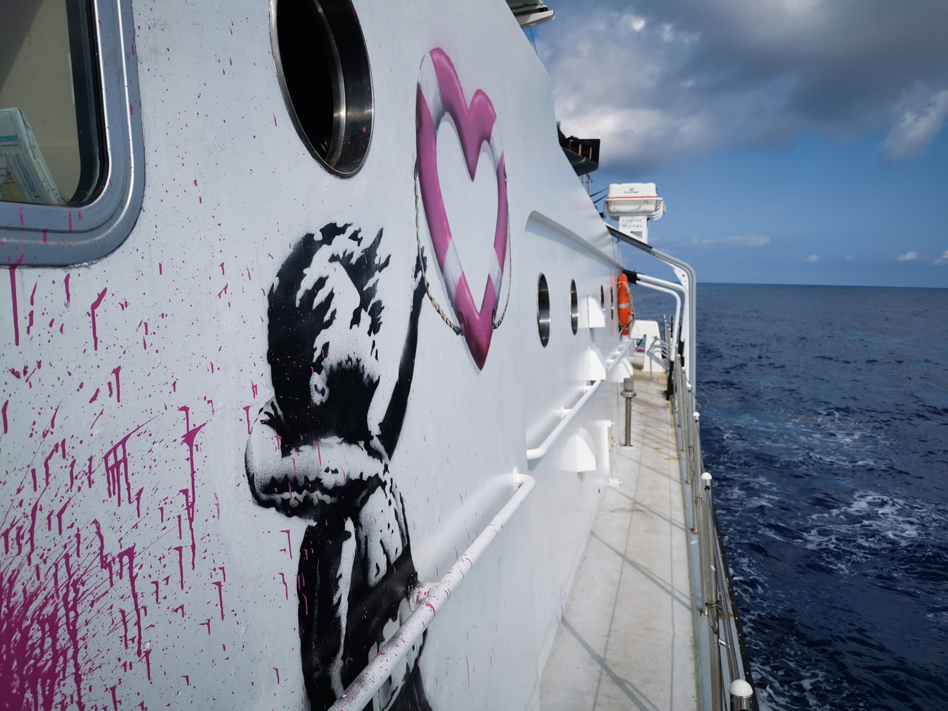
Painted in bright pink and featuring Banksy artwork depicting a girl in a life vest holding a heart-shaped safety buoy, the Louise Michel sails under a German flag.
The 31-metre motor yacht, formerly owned by French customs authorities, is smaller but considerably faster than other NGO rescue vessels.
Banksy’s involvement in the rescue mission goes back to September 2019 when he sent an email to Pia Klemp, the former captain of several NGO boats that have rescued thousands of people over recent years.
The vessel set off in secrecy from the Spanish port of Burriana, near Valencia.
Photograph: Ruben Neugebauer
“Hello Pia, I’ve read about your story in the papers.
You sound like a badass,” he wrote.
“I am an artist from the UK and I’ve made some work about the migrant crisis, obviously I can’t keep the money. Could you use it to buy a new boat or something? Please let me know.
Well done. Banksy.”
Klemp, who initially thought it was a joke, believes she was chosen by Banksy due to her political stance.
“I don’t see sea rescue as a humanitarian action, but as part of an anti-fascist fight,” she told the Guardian.
Banksy, Mediterranean Sea View 2017, detail.
The triptych is expected to sell for £800,000–1,200,000 (about $1 million–$1.5 million).
Photo courtesy of Sotheby’s London.
She has made clear that Banksy’s involvement in the operations is limited to providing financial support.
“Banksy won’t pretend that he knows better than us how to run a ship, and we won’t pretend to be artists.”
With a top speed of 27 knots, the Louise Michel would be able to “hopefully outrun the so-called Libyan coastguard before they get to boats with refugees and migrants and pull them back to the detention camps in Libya”, said Klemp.
Pia Klemp in October 2017.
Photograph: Lisa Hoffmann
Non-state sea rescuers have long criticised the mass return of migrants to Libya by the Libyan coastguard in collaboration with EU member states.
International organisations have accused the Libyan coastguard of mistreating people at sea or selling them off to militias at Libyan harbours after intercepting them.
According to the International Organization for Migration, more than 7,600 migrants have been intercepted so far this year and returned to Libya, a war-torn country where different political factions continue to struggle for power.
Often confined to informal camps, the situation for migrants in Libya is desperate, with acts of systematic torture and rape long documented by human rights organisations.
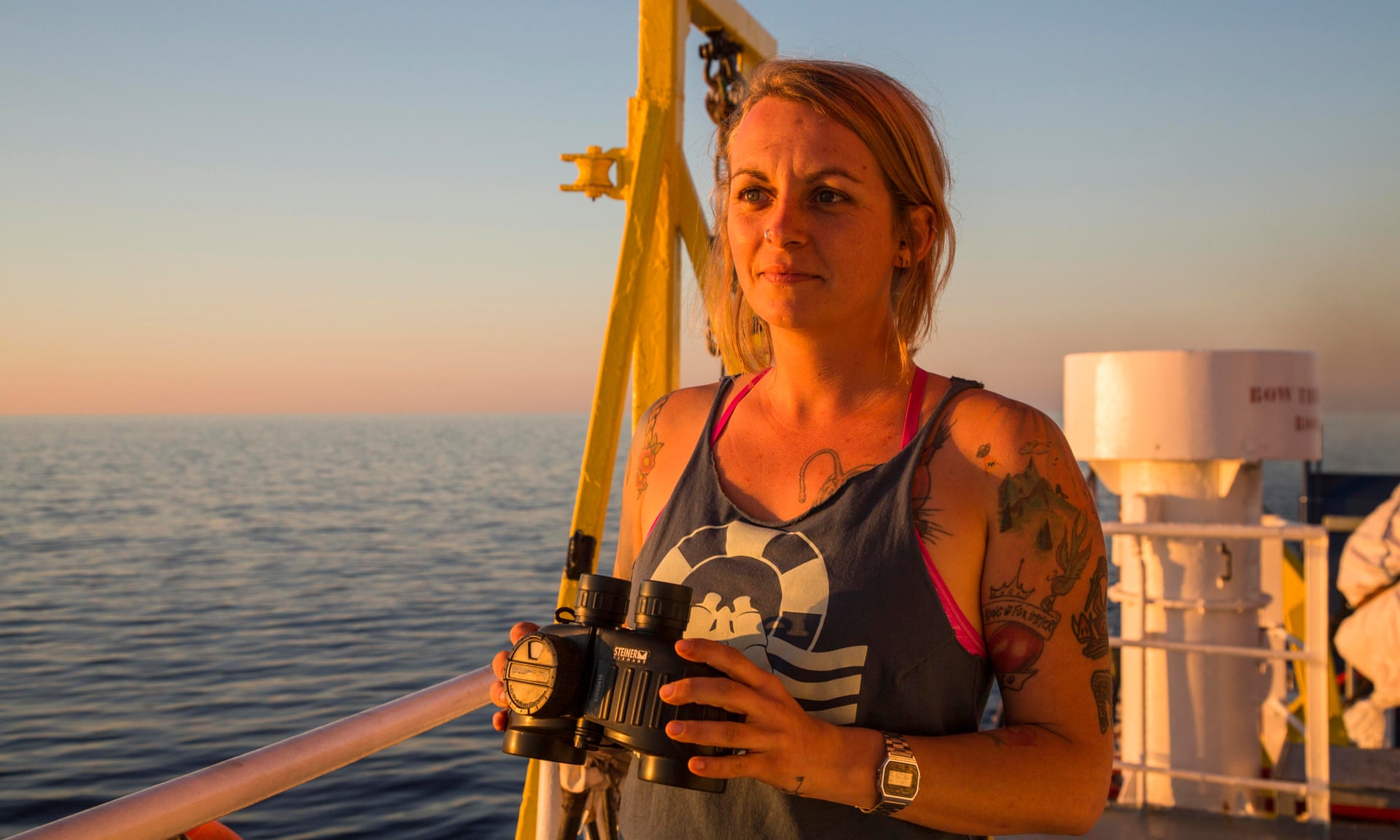
The 10 crew members of the Louise Michel have diverse backgrounds, but they all identify as anti-racist and anti-fascist activists advocating for radical political change.
As it is a feminist project, only female crew members are allowed to speak in the name of the Louise Michel.
Lea Reisner, a nurse and head of mission for the first rescue operation, said the project was anarchist at its heart, meant to bring together a variety of struggles for social justice, including for women’s and LGBTIQ rights, racial equality, migrants’ rights, environmentalism and animal rights.
The planning of the mission was carried out in secrecy between London, Berlin and Burriana, where the Louise Michel had docked to be equipped for sea rescues.
The crew feared that media attention could compromise their goals: if word had circulated that a project financed by Banksy would soon sail toward the central Mediterranean to rescue migrants, the European authorities could have attempted to thwart the mission.
For this reason, Banksy’s team and the rescue activists agreed to release the news about the boat only after carrying out the first rescue.
In the past week, the Louise Michel already assisted #SeaWatch4 in two operations,
and rescued 89 people itself.
The Louise Michel is the latest intervention by members of civil society seeking to prevent deaths in the Mediterranean.
Other NGO rescuers have engaged in rescue activities this year but have been impeded by what they consider to be excessive and politically motivated inspections carried out by Italian authorities.
Covid-19 lockdowns and restrictions have also affected sea rescue activities, with NGO crews unable to return to the central Mediterranean for the last several weeks.
So far in 2020, more than 500 refugees and migrants are known to have died in the Mediterranean sea, and the real number is estimated to be considerably higher.
On Wednesday, 45 people – including five children – died when the engine on their boat exploded off Libya, in the country’s deadliest shipwreck this year, the UN said.
More than 19,500 migrants have survived the Mediterranean crossing along the central maritime route this year and reached Italy or Malta.
Claire Faggianelli, an activist who prepared the Louise Michel for its first mission, saw the project as a wake-up call for Europe.
“We really want to try to awaken the consciousness of Europe and say: ‘Look, we have been yelling at you for years now. There is something that shouldn’t be happening at the very borders of Europe, and you close your eyes to it. Wake up!’” she said.
Charles H. Hapgood began his book, Maps of the Ancient Sea Kings, by stating, after studying composite maps at least partially derived from ancient sources, that ancient voyagers traveled from pole to pole.
The evidence, he said, indicated that some ancient people explored Antarctica when its coasts were free of ice.
It is clear too that they had an instrument of navigation for accurately determining longitudes that was far superior to anything possessed by the peoples of the ancient, medieval, or modern times until the second half of the 18th century.
Some scholars have long claimed that a world civilization existed
thousands of years ago - long before Egypt.
They have even claimed that
this lost civilization was almost as advanced as ours today. In
this book, Professor Charles H. Hapgood has produced the first concrete
evidence of the existence of such a civilization.
He has found the
evidence in many beautiful maps long known to scholars, the so-called
Portolano charts of the Middle Ages, and in other maps until now thought
to have originated around the time of Columbus.
Working with his
students over a period of seven years, Hapgood has discovered evidence
that many of these maps must have originated in a civilization in some
ways much more advanced scientifically than Europe in the 16th Century,
or than the ancient civilizations of Greece, Egypt, and Babylonia. Not
only were these unknown people more advanced in mapmaking than any
people prior to the 18th Century, it appears that they mapped all the
continents.
The Americas were mapped thousands of years before Columbus.
Antarctica was mapped when its coasts were still free of ice.
There is
evidence that these people must have lived when the ice age had not yet
ended in the Northern Hemisphere and when Alaska was still connected
with Siberia by the Pleistocene, ice age 'land bridge.' In this
book, Hapgood has not merely modified our ideas about ancient history,
but his work will necessitate a widespread revolution in our concepts
about the whole history of man, the history of his science, and the
evolution of human culture.
Hapgood shows that man's evolution from
brute to citizen of the world spans a longer time than we have ever
supposed.
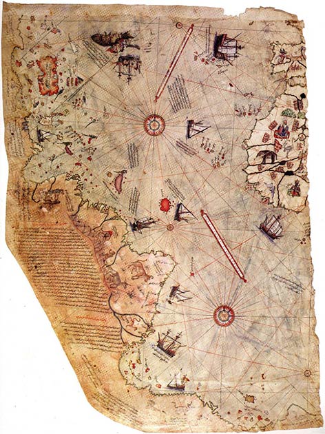
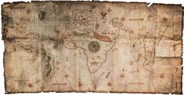
The Piri Reis Map of 1513
Hapgood became interested in the study of ancient maps after reading a book on the subject by Captain A.H Mallory, Lost America .
Mallory had come across a copy of the Piri Reis Map , a world map compiled in 1513 by the Ottoman admiral and cartographer, Piri Reis.
He said publicly that the map seemed to show Antarctica, before it was discovered, and, furthermore, the coast seemed to have been mapped when it was free of ice.
In addition, Mallory’s opinion had been endorsed by the directors of the astronomical observatories at Boston College and Georgetown University.
As a result of Mallory’s inquiry, Hapgood’s initial interest was focused on the Piri Reis Map.
Hapgood found that it showed South America and Africa in correct relative longitudes.
This was most remarkable, for the navigators of the 16th century had no means of finding longitude except by guesswork.
Another amazing thing that attracted him to this map was that it appeared to show the continent of Antarctica, three centuries before it was discovered in 1818.
Antarctica is actually two large bodies of land, Greater and Lesser Antarctica.
However, when we refer to Antarctica as a continent, we are referring to Greater Antarctica, which is roughly the size of the continental United States.
Writing to the United States Air Force, he asked if there was any correlation between various geographical details on the Piri Reis Map and results of seismic findings conducted by the Swedish-British-Antarctic Expedition of 1949.
The report showed there was high correlation between Antarctica under the ice with large portions of the map.
In fact, it corresponded with fifty-five specific geographical locations on the continent.
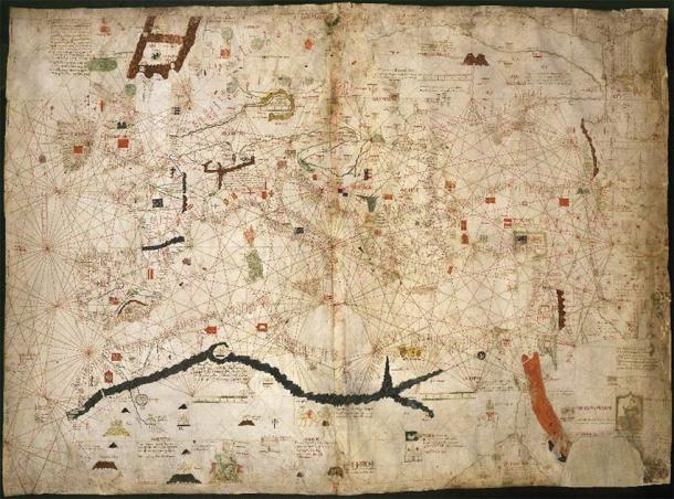
The maps that Hapgood studied were portolano, or port to port, maps.
Portolan charts came about in the late 13th century.
Portolan charts were realistic depictions of coastlines and their ports, drawn by navigators from their own experience and for their own guidance.
Hapgood thought it odd that some of the early maps seemed too accurate to have been drawn by medieval sailors and that successive charts showed no signs of development.
After comparison, he found that the portolanos were much more accurate than maps made by Ptolemy, the most famous geographer in the ancient world, in the 2nd century AD.
1439 portolan chart by Gabriel de Vallseca (Museu Maritim, Barcelona).
Hapgood and his students spent three years searching for the center of the map, which they found to be at the ancient city of Syene, in Egypt near Giza.
Consulting a mathematician, he learned that the projections on the map had been made by plane trigonometry.
In addition, Hapgood found that some of the positions on the Piri Reis Map were very accurate, and some were far off.
Gradually, he became aware of the reasons for some of the inaccuracies in the map.
He discovered that the map was a composite, made by piecing together many maps of local areas (perhaps drawn at different times by different people), and that the errors had been made in combining the original maps.
According to Colin Wilson and Rand and Rose Flem-Ath in their book, The Atlantis Blueprint , the ancient maps were frequently accurate to within one half-degree of longitude—something Europeans didn’t achieve until the invention of the marine chronometer in the eighteenth century.
Determining Longitude
Determining latitude was relatively easy since it could be found from the altitude of the sun at its highest point with the aid of a table giving the sun's declination for the day, or from many stars at night.
For longitude, early ocean navigators had to rely on dead reckoning, the process of calculating one's current position by using a previously determined position, or fix, and advancing that position based upon known or estimated speeds over elapsed time and course.
This was inaccurate on long voyages out of sight of land and these voyages sometimes ended in tragedy as a result.
In order to avoid problems with not knowing one's position accurately, navigators have, where possible, relied on taking advantage of their knowledge of latitude.
They would sail to the latitude of their destination, turn toward their destination, and follow a line of constant latitude.
This was known as running down a westing, if westbound, easting, otherwise.
This prevented a ship from taking the most direct route or a route with the most favorable winds and currents, extending the voyage by days or even weeks.
This increased the likelihood of short rations, which could lead to poor health or even death for members of the crew due to scurvy or starvation, with resultant risk to the ship .
Others thought the answer lay in chronometry, developing an improved timepiece that would work even on extended voyages at sea.
A suitable one was eventually built by Yorkshire carpenter John Harrison, using his marine chronometer.
Though the British Parliament partially rewarded Harrison for his timepiece that contributed to an accurate marine chronometer in 1773, his chronometers were not to become standard.
Chronometers such as those invented by Thomas Earnshaw were in general nautical use until the middle of the 19th century.
However, they remained very expensive and other methods were used instead.
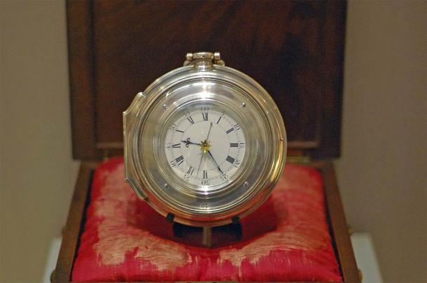
Harrison's Chronometer H5 of 1772, now on display at the Science Museum, London.
Hapgood knew that the ancient Greek geographer, Eratosthenes, living about a century before the supposed invention of trigonometry, had overestimated the circumference of the earth by four- and one-half percent.
Redrawing the map to account for these errors, Hapgood and his students came to a startling discovery: The Greek geographers of Alexandria, when they prepared their world map using the circumference of Eratosthenes, had in front of them source maps that had been drawn without the Eratosthenian error- that is, apparently without any discernible error at all.
Hapgood concluded that errors in the Piri Reis Map were due to mistakes in its compilation, presumably in Alexandrian times, and derived from ancient source maps.
This agrees with Peter Tompkins, who, in his book Secrets of the Great Pyramid , suggests that the Alexandrian geographers did not understand the information they were handling, which was based on an advanced science that preceded them.
Sections of the Piri Reis Map, according to Hapgood, seem to be extremely accurate and, he concluded, the original mapmaker must have found correct relative longitude across Africa and across the Atlantic from the meridian of Alexandria to Brazil.
This is amazing when one considers that Columbus, in 1492, made serious mistakes in finding latitude, and, of course, had no way of determining longitude, resulting in over a 1250-mile (2011.68 km) miscalculation of his location when he arrived at San Salvador in the Caribbean.
There are suggestions, however, that Columbus had maps of Cuba before his first voyage.
Implicit, of course, in this assessment is that the Piri Reis Map is evidence of a decline of science from remote antiquity to classical times.
Spherical Trigonometry
Hapgood realized that one reason that ancient Greek geographers had difficulty interpreting these source maps was that they were compiled using spherical trigonometry:
What else can we conclude but that the mapmaker, confronted by a spherical projection he did not understand, had to translate his geographical data (latitudes and longitudes of places in the Caribbean) into terms of a flat surface? This contains the implication, of course, that spherical trigonometry must have been known ages before its supposed invention by Hipparchus in the second century BC.
It also raises another question: How did it happen that a world map, apparently drawn ages before Hipparchus, was centered on Egypt? Can we ascribe advanced knowledge to the Egyptians? It seems that perhaps we can.
The ancient Egyptians, but not the Greeks, Hapgood concluded, knew the science of translating spherical surfaces into flat ones of equal areas, or vice versa, by using the mathematical phi relationship.
Since the Greeks did not understand this, they distorted the information handed down to them.
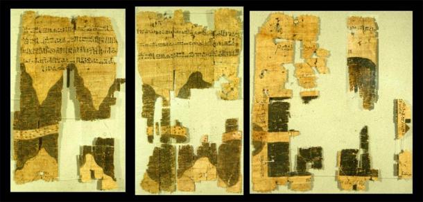
Right half of the ancient Egyptian Turin papyrus map.
Hapgood concluded that the ancient Egyptians had more advanced science than the Greeks.
Hapgood was aware that maps were available that showed other places in the New World.
Among these locations were the Andes Mountains, and the drawing of the mountains indicates that they were observed from the sea, the mouth of the Amazon River, the St.
Lawrence River, and the eastern half of Cuba.
For instance, a point of considerable interest is the shape of the Atrato River.
The river is shown for a distance of 300 miles (482.8 km) from the sea and its eastward bend at five degrees North Latitude corresponds to the geographical facts.
This suggests that somebody explored the river to its headwaters in the western cordillera of the Andes sometime before 1513.
There is no known record of such an exploration.
We already know that the ancients mined tin in the Andes Mountains and copper around Lake Superior, since bronze requires both of these materials.
They would have needed maps to get to these places.
John White, in his book, Pole Shift , notes that Hapgood never mentioned the word ‘Atlantis.’ However, Hapgood did talk about “a great island” on the Piri Reis Map in the Atlantic Ocean.
Since it was so carefully drawn, and since Hapgood believed this island would have been ideally suited by climate and location for agricultural and commercial development and as a base for navigation, he concluded that this may have been the home for the people who developed the maps.
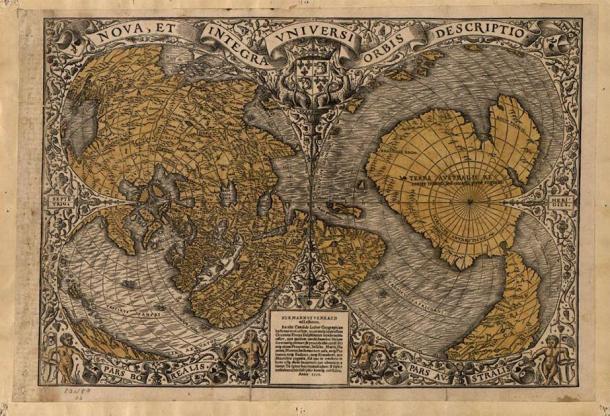
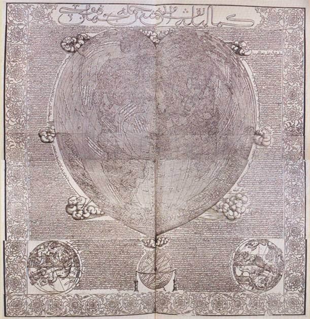
Oronteus Finaeus Map of 1531
In 1959, while studying maps in the Library of Congress, Hapgood sat transfixed: “As my eyes fell upon the southern hemisphere of a world map drawn by Oronteus Finaeus in 1531, I had the instant conviction that I had found here a truly authentic map of the real Antarctica.”
The mountain ranges shown were individualized, some being on the coast and others inland.
The map showed rivers flowing into the sea, suggesting the coasts may have been ice free when the original map was drawn.
The most interesting thing was that once Hapgood corrected the map for scale, he concluded that the size of the Antarctic Continent on the map of Oronteus Finaeus was correct by modern findings.
He concluded that as the ancients had a correct idea of the size of the Antarctica Continent suggests that they may have had a correct idea of the size of the earth as well; knowledge that is reflected in the Piri Reis Map.
Gerhard Kremer, known as Mercator (1512-1594), the most famous cartographer of the 16th century, compiled an Atlas which included the Oronteus Finaeus Map as well as another map, drawn from source maps, called the Mercator Map.
This map showed numerous points on the continent of Antarctica clearly.
According to Hapgood, Mercator had source maps available to him other than Oronteus Finaeus.
Mercator complied his Atlas in 1538 and, as maps were being drawn by early explorers, revised this in 1569 to reflect changes reported by them.
Hapgood states: “Oddly enough, in his map of 1538, thirty years earlier, Mercator had represented the west coast of South America much more correctly.” Hapgood suggested that the first map depended on ancient sources while the latter map relied on feedback from early explorers, who had no accurate longitude and so could merely guess at the trends of coasts.
The Dulcet Portolano Map of 1339
The Dulcet Portolano Map of 1339 appeared in Europe in the early 14th century.
According to Hapgood, the map reflects accurate information on the latitudes and longitudes of places scattered all the way from Galway in Ireland to the eastern bend of the Don in Russia.
A.E.
Nordenskiold, in his nineteenth century book, The Voyage of the Vega Round Asia and Europe , had earlier concluded that no medieval mapmaker could have drawn this map.
Hapgood believed that the mapmaker used spherical trigonometry in the compilation of this map.
Hapgood believed that the mapmaker used spherical trigonometry in the compilation of the Dulcet Portolano Map of 1339.
The De Canerio Map of 1502, covering the whole continent of Africa as well as Asia, shows remarkable accuracy in latitude and longitude.
According to Hapgood, the average error in latitudes of 11 places - Gibraltar, the northern coasts of Sardinia, Sicily, Cyprus, and Crete; Cape Bon, Bengazi, Lesbos, the Bosphorus, Sevastopol, and Batum - was only one half of one degree.
The longitudinal distance between Gibraltar was accurate, proportional to the latitude, suggesting there may have been no significant error in the original source map as to the size of the earth.
Hapgood was shown numerous other maps .
These maps showed accuracy in latitude and longitude, which are only surpassed by modern maps.
He concludes that this reflects the mapmaking of an advanced ancient culture.
The Haji Ahmad map, which appeared in Turkey in 1559, shows the American continent so accurately that it could easily be mistaken for a modern map.
Strangely, it shows Asia and Alaska joined together.
It does not show Beringia, the land bridge across the Bering Strait, which was submerged at the end of the last Ice Age.
Hapgood speculated that the Hadji Ahmed map was based on far earlier maps that date back to a long-forgotten civilization of ‘ancient sea kings.’
Hapgood admitted that about 900 miles (1448.41 km) of South American coastline are missing from the map.
He addressed many more specific criticisms, and also pondered: Could Piri Reis, entirely by chance, have placed a range of enormous mountains in approximately the same place where there is a range of enormous mountains?
Furthermore, the Hapgood team identified 50 geographical points on the Finaeus map, as re-projected, whose latitudes and longitudes were located quite accurately...
some of them quite close to the pole...
There are other factors, too.
The cartography of the Age of Discovery, for instance, often seems to have been independent of the voyages themselves, that is, certain maps of America contain features before their supposed date of discovery.
Looking at all this data, Hapgood concluded that an advanced civilization existed in prehistory .
This intelligent culture, he estimated, lived up to 100,000 years ago.
This agrees with mystics such as Theosophists, Rosicrucians, and the American psychic, Edgar Cayce.
Compare that to conventional science, which proposes our ancestors were hunters and gathers at this time.
It begs the question: Who’s correct?
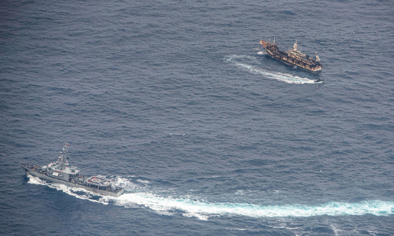
An Ecuadorian navy vessels challenges a fishing boat on 7 August after a
fleet of mostly Chinese-flagged ships were detected in the Pacific
Ocean. Photograph: Santiago Arcos/Reuters
From The Guardian by Dan Collyns Ecuador stood up for the Galápagos, but other countries don’t stand a chance against the 17,000-strong distant-water fleet
The recent discovery by the Ecuadorean navy of a vast fishing armada of 340 Chinese vessels just off the biodiverse Galápagos Islands stirred outrage both in Ecuador and overseas.
Under pressure after Ecuador’s strident response, China has given mixed signals that it could begin to reel in its vast international fishing fleet.
Its embassy in Ecuador declared a “zero tolerance” policy towards illegal fishing, and this week it announced it was tightening the rules for its enormous flotilla with a series of new regulations.
But with 325 of those 340 ships remaining off Ecuador, and local navy commander Darwin Jarrín saying last week that nearly half of those vessels had intermittently switched off their satellite communications – breaching the rules of the regional fisheries management organisation – the episode has shown how difficult it is for small nations to stand up to China’s distant fleet even when it descends on the archipelago that inspired Charles Darwin’s Theory of Evolution.
China’s vast fishing fleet, by far the world’s largest, has been overfishing seas much further from the world’s gaze than the islands known for their giant tortoises and iguanas.
From West Africa’s Gulf of Guinea to the Korean peninsula, the fleet has moved into the waters of other countries – switching off transponders to avoid detection, depleting fish stocks and threatening food security for often poor coastal communities.
In east Asia, fishing vessels may act as the vanguard of an aggressive geopolitical strategy aimed at asserting territorial claims.
China’s new regulations this week include harsher penalties for companies and captains involved in illegal, unreported and unregulated – or IUU – fishing.
But conservationists monitoring the Galápagos episode are sceptical.
“Beyond this one-sided announcement, the problem remains the same,” says Pablo Guerrero, marine conservation director for WWF Ecuador.
“These boats operate without observers on board, they do not return to port, they transship their catch to mother vessels, which land the catch at ports.
So, in a nutshell, they are fishing all the time, the fishing operation doesn’t stop.”
The fleet is a vast and complex network.
Among the hundreds of vessels are fuel providers, fishing boats, tender boats and reefers, some of which camouflage unregistered boats, Guerrero says.
Many ships spend long periods at sea where shocking human rights violations have been reported.
NGO Global Fishing Watch and the Overseas Development Institute (ODI) thinktank have used cutting-edge technology and data analysis to reveal that the size and scope of China’s distant-water fleet has been hugely underreported.
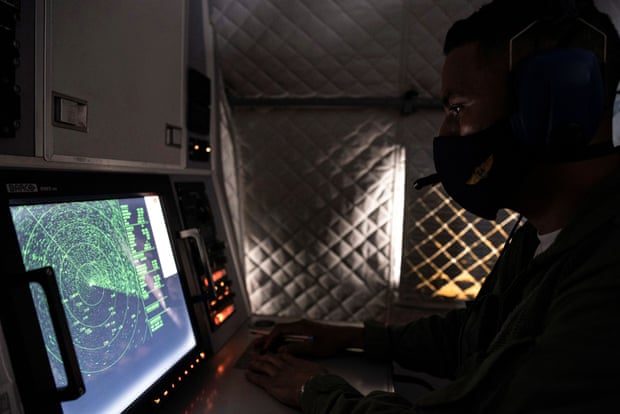
An Ecuadorian navy officer looks at a radar on 7 August after the mostly Chinese-flagged fleet was detected in an international corridor that borders the Galápagos Islands. Photograph: Santiago Arcos/Reuters
The ODI found the fleet had 16,966 vessels, five times more than previous estimates.
By contrast, the US distant-water fleet comprises 300 boats.
In 2017, as part of its 13th fisheries five-year plan, China announced plans to cap the size of the fleet to 3,000 vessels by 2020.
“We were shocked by the results because we were expecting 4,000 or 5,000 vessels,” says Miren Gutiérrez, the lead author of the ODI report.
The research, which took more than a year, also found nearly 1,000 of the boats were using “flags of convenience” and at least 183 vessels were involved in suspected IUU fishing, for which China ranked the worst-performing nation in a 2019 global index.
“On the surface, it looks like a very fragmented fleet, but we suspect the core of it is probably in the hands of a few companies,” says Gutiérrez. Recent research shows the Chinese government heavily subsidises fishing through tax exemptions, mostly on fuel, to the value of $16.6bn (£12.6bn) per year, or 47% of total global fishing subsidies.
“Most of this overfishing is not illegal, that’s the problem,” Gutiérrez says, as most of it goes on in international waters.
Most of the fleet’s vessels are trawlers – banned within China’s territorial waters and notorious for damaging ecosystems by dragging nets along the seafloor.
Other common boats are longliners, for larger fish such as tuna or shark, and squid-jiggers, which usually operate in deeper waters.
“To shift the dynamic there needs to be radical transparency,” says Philip Chou, an expert on distant-water fishing at Oceana, a marine conservation group.
“So far, the evidence has not shown that [the Chinese government] has taken it further than rhetoric.”
China would need to open up about its catch, the real-time location of its fleets, the ownership of fishing vessels, and the opaque bilateral or regional agreements it has made with low-income coastal nations, Chou says.
In west Africa, for example, a 2018 report by the Environmental Justice Foundation found 90% of Ghanaian-flagged vessels had Chinese involvement.
Protesters outside the Chinese embassy in Quito, Ecuador, earlier this month call for fisheries control.
Photograph: José Jácome/EPA
China’s self-declared shake-up proposes changes to high-seas transshipment rules – the movement of cargo from one vessel to another – along with reforms to distant-water fishing.
It also announced two three-month fishing moratoriums: one west of the Galápagos, between September and November, and another beginning in July in the south Atlantic near Argentina.
The world’s biggest seafood exporter is also mooted to be planning to ratify the Port State Measures Agreement, the first internationally binding accord in which ports around the world pledge not to allow illegal or unregulated fishing boats to land catches.
'They just pull up everything!' Chinese fleet raises fears for Galápagos sea life
“It’s a significant concession,” says Steve Trent, executive director of the Environmental Justice Foundation.
“But in the context of global fisheries it’s not enough, it’s not nearly enough.”
China hauled up about 15% of the world’s reported fishing catch in 2018, according to the UN fisheries agency, more than twice the second- and third-ranking countries.
But the lack of transparency means it is impossible to truly know how much seafood humans take from the ocean amid an alarming drop in marine life in the past half-century.
The UN’s Food and Agriculture Organization (FAO) estimates that illegal fishing has an annual cost of up to $23bn.
The FAO also calculatesd that nearly 60 million people worked in fishing or aquaculture in 2016, 85% of them in Asia.
Ecuador is one of a few small nation states that have pushed back against the Chinese flotillas.
In the hotly disputed South China Sea, Indonesia sent F-16 fighter jets along with navy, coastguard and fishing boats to repel 63 Chinese fishing boats and four coastguard vessels from its waters in January.
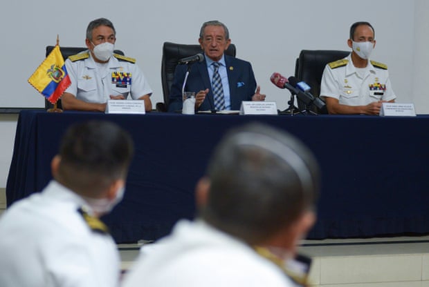
Ecuador’s defence minister, Oswaldo Jarrin, flanked by navy admirals, at a press conference, in the port city of Guayaquil, about the Chinese fleet operating near the Galápagos Islands.
Photograph: Reuters
But North Korean fishing boats may have come off worse from exchanges with China’s “dark fleets”, amid reports of “ghost boats” washing up on Japanese shores containing the bodies of North Korean fishermen.
In its backyard, the Chinese fleet has a fearsome reputation for systemic illegal fishing and aggressive tactics when faced with competitors or foreign patrol vessels.
China signed a key UN fish stocks agreement in 1996 but never ratified it.
It is a member of seven regional fishery management organisations, or RFMOs, but its distant water fleet operates outside of those frameworks, says Mercedes Rosello, director of House of Ocean, a not-for-profit legal consultancy that monitors IUU fishing.
“When you are looking at thousands of vessels, the rules and mechanisms which that flag state adopts are of huge transcendence,” Rosello says.
The US, Japan, and the EU, which make up about 70% of the global seafood market, need to take proactive measures to disrupt IUU fish from Chinese vessels from entering international supply chains, says Trent.
“[Without] wholescale structural change by China and the system of global governance of the ocean to make sure the Chinese do abide by the law,” he says, the world’s fish stocks would continue their precipitous decline.
“The people who suffer first and worst are almost always the coastal communities who rely on those fisheries for their survival, wellbeing and food,” he says.
“Exactly what happens in the Galápagos [Islands] happens in locations around the world and it’s terrifying.”
Earth’s magnetic field acts like a protective shield around the planet, repelling and trapping charged particles from the Sun.
But over South America and the southern Atlantic Ocean, an unusually weak spot in the field – called the South Atlantic Anomaly, or SAA – allows these particles to dip closer to the surface than normal.
Currently, the SAA creates no visible impacts on daily life on the surface.
However, recent observations and forecasts show that the region is expanding westward and continuing to weaken in intensity.
The South Atlantic Anomaly is also of interest to NASA’s Earth scientists who monitor the changes in magnetic strength there, both for how such changes affect Earth's atmosphere and as an indicator of what's happening to Earth's magnetic fields, deep inside the globe.
From NASA by Mara Johnson-Groh and Jessica Merzdorf
A small but evolving dent in Earth’s magnetic field can cause big headaches for satellites.
Earth’s magnetic field acts like a protective shield around the planet, repelling and trapping charged particles from the Sun.
But over South America and the southern Atlantic Ocean, an unusually weak spot in the field – called the South Atlantic Anomaly, or SAA – allows these particles to dip closer to the surface than normal.
Particle radiation in this region can knock out onboard computers and interfere with the data collection of satellites that pass through it – a key reason why NASA scientists want to track and study the anomaly.
The South Atlantic Anomaly is also of interest to NASA’s Earth scientists who monitor the changes in magnetic field strength there, both for how such changes affect Earth's atmosphere and as an indicator of what's happening to Earth's magnetic fields, deep inside the globe.
Currently, the SAA creates no visible impacts on daily life on the surface.
However, recent observations and forecasts show that the region is expanding westward and continuing to weaken in intensity.
It is also splitting – recent data shows the anomaly’s valley, or region of minimum field strength, has split into two lobes, creating additional challenges for satellite missions.
A host of NASA scientists in geomagnetic, geophysics, and heliophysics research groups observe and model the SAA, to monitor and predict future changes – and help prepare for future challenges to satellites and humans in space.
It’s what’s inside that counts
The South Atlantic Anomaly arises from two features of Earth’s core: The tilt of its magnetic axis, and the flow of molten metals within its outer core.
Earth is a bit like a bar magnet, with north and south poles that represent opposing magnetic polarities and invisible magnetic field lines encircling the planet between them.
But unlike a bar magnet, the core magnetic field is not perfectly aligned through the globe, nor is it perfectly stable.
That’s because the field originates from Earth’s outer core: molten, iron-rich and in vigorous motion 1800 miles below the surface.
These churning metals act like a massive generator, called the geodynamo, creating electric currents that produce the magnetic field.
As the core motion changes over time, due to complex geodynamic conditions within the core and at the boundary with the solid mantle up above, the magnetic field fluctuates in space and time too.
These dynamical processes in the core ripple outward to the magnetic field surrounding the planet, generating the SAA and other features in the near-Earth environment – including the tilt and drift of the magnetic poles, which are moving over time.
These evolutions in the field, which happen on a similar time scale to the convection of metals in the outer core, provide scientists with new clues to help them unravel the core dynamics that drive the geodynamo.
“The magnetic field is actually a superposition of fields from many current sources,” said Terry Sabaka, a geophysicist at NASA’s Goddard Space Flight Center in Greenbelt, Maryland.
Regions outside of the solid Earth also contribute to the observed magnetic field.
However, he said, the bulk of the field comes from the core.
The forces in the core and the tilt of the magnetic axis together produce the anomaly, the area of weaker magnetism – allowing charged particles trapped in Earth’s magnetic field to dip closer to the surface.
When solar material streams strikes Earth’s magnetosphere, it can become trapped and held in two donut-shaped belts around the planet called the Van Allen Belts.
The belts restrain the particles to travel along Earth’s magnetic field lines, continually bouncing back and forth from pole to pole.
The Sun expels a constant outflow of particles and magnetic fields known as the solar wind and vast clouds of hot plasma and radiation called coronal mass ejections.
When this solar material streams across space and strikes Earth’s magnetosphere, the space occupied by Earth’s magnetic field, it can become trapped and held in two donut-shaped belts around the planet called the Van Allen Belts.
The belts restrain the particles to travel along Earth’s magnetic field lines, continually bouncing back and forth from pole to pole.
The innermost belt begins about 400 miles from the surface of Earth, which keeps its particle radiation a healthy distance from Earth and its orbiting satellites.
However, when a particularly strong storm of particles from the Sun reaches Earth, the Van Allen belts can become highly energized and the magnetic field can be deformed, allowing the charged particles to penetrate the atmosphere.
“The observed SAA can be also interpreted as a consequence of weakening dominance of the dipole field in the region,” said Weijia Kuang, a geophysicist and mathematician in Goddard’s Geodesy and Geophysics Laboratory.
“More specifically, a localized field with reversed polarity grows strongly in the SAA region, thus making the field intensity very weak, weaker than that of the surrounding regions.”
A pothole in space
Although the South Atlantic Anomaly arises from processes inside Earth, it has effects that reach far beyond Earth’s surface.
The region can be hazardous for low-Earth orbit satellites that travel through it.
If a satellite is hit by a high-energy proton, it can short-circuit and cause an event called single event upset or SEU.
This can cause the satellite’s function to glitch temporarily or can cause permanent damage if a key component is hit.
In order to avoid losing instruments or an entire satellite, operators commonly shut down non-essential components as they pass through the SAA.
Indeed, NASA's Ionospheric Connection Explorer regularly travels through the region and so the mission keeps constant tabs on the SAA's position.
The International Space Station, which is in low-Earth orbit, also passes through the SAA.
It is well protected, and astronauts are safe from harm while inside.
However, the ISS has other passengers affected by the higher radiation levels: Instruments like the Global Ecosystem Dynamics Investigation mission, or GEDI, collect data from various positions on the outside of the ISS.
The SAA causes “blips” on GEDI’s detectors and resets the instrument’s power boards about once a month, said Bryan Blair, the mission’s deputy principal investigator and instrument scientist, and a lidar instrument scientist at Goddard.
“These events cause no harm to GEDI,” Blair said.
“The detector blips are rare compared to the number of laser shots – about one blip in a million shots – and the reset line event causes a couple of hours of lost data, but it only happens every month or so.”
The Sun expels a constant outflow of particles and magnetic fields known as the solar wind and vast clouds of hot plasma and radiation called coronal mass ejections.
This solar material streams across space and strikes Earth’s magnetosphere, the space occupied by Earth’s magnetic field, which acts like a protective shield around the planet.
In addition to measuring the SAA’s magnetic field strength, NASA scientists have also studied the particle radiation in the region with the Solar, Anomalous, and Magnetospheric Particle Explorer, or SAMPEX – the first of NASA’s Small Explorer missions, launched in 1992 and providing observations until 2012.
One study, led by NASA heliophysicist Ashley Greeley as part of her doctoral thesis, used two decades of data from SAMPEX to show that the SAA is slowly but steadily drifting in a northwesterly direction.
The results helped confirm models created from geomagnetic measurements and showed how the SAA’s location changes as the geomagnetic field evolves.
“These particles are intimately associated with the magnetic field, which guides their motions,” said Shri Kanekal, a researcher in the Heliospheric Physics Laboratory at NASA Goddard.
“Therefore, any knowledge of particles gives you information on the geomagnetic field as well.”
Greeley’s results, published in the journal Space Weather, were also able to provide a clear picture of the type and amount of particle radiation satellites receive when passing through the SAA, which emphasized the need for continuing monitoring in the region.
The information Greeley and her collaborators garnered from SAMPEX’s in-situ measurements has also been useful for satellite design.
Engineers for the Low-Earth Orbit, or LEO, satellite used the results to design systems that would prevent a latch-up event from causing failure or loss of the spacecraft.
Modeling a safer future for satellites
In order to understand how the SAA is changing and to prepare for future threats to satellites and instruments, Sabaka, Kuang and their colleagues use observations and physics to contribute to global models of Earth’s magnetic field.
The team assesses the current state of the magnetic field using data from the European Space Agency’s Swarm constellation, previous missions from agencies around the world, and ground measurements.
Sabaka’s team teases apart the observational data to separate out its source before passing it on to Kuang’s team.
They combine the sorted data from Sabaka’s team with their core dynamics model to forecast geomagnetic secular variation (rapid changes in the magnetic field) into the future.
“This is similar to how weather forecasts are produced, but we are working with much longer time scales,” he said.
“This is the fundamental difference between what we do at Goddard and most other research groups modeling changes in Earth’s magnetic field.”
One such application that Sabaka and Kuang have contributed to is the International Geomagnetic Reference Field, or IGRF.
Used for a variety of research from the core to the boundaries of the atmosphere, the IGRF is a collection of candidate models made by worldwide research teams that describe Earth’s magnetic field and track how it changes in time.
“Even though the SAA is slow-moving, it is going through some change in morphology, so it’s also important that we keep observing it by having continued missions,” Sabaka said.
“Because that’s what helps us make models and predictions.”
The changing SAA provides researchers new opportunities to understand Earth’s core, and how its dynamics influence other aspects of the Earth system, said Kuang.
By tracking this slowly evolving “dent” in the magnetic field, researchers can better understand the way our planet is changing and help prepare for a safer future for satellites.
UNCLASSIFIED//
ROUTINE
R 071418Z AUG 20 MID510001583052U
FM CNO WASHINGTON DC
TO NAVADMIN
INFO CNO WASHINGTON DC
BT
UNCLAS

NAVADMIN 221/20

MSGID/NAVADMIN/CNO WASHINGTON DC/N2N6/AUG//
 SUBJ/TRANSITION TO ELECTRONIC NAVIGATIONAL CHART//

REF/A/PUB/IHO/1NOV00//
REF/B/DOC/NATO/27SEP15//
REF/C/PUB/NSG/1MAY20//
REF/D/INST/OPNAV/30SEP19//

NARR/REF A IS AN INTERNATIONAL HYDROGRAPHIC ORGANIZATION (IHO) PUBLICATION
WHICH DESCRIBES THE ELECTRONIC NAVIGATIONAL CHART (ENC) S-57 FORMAT.
REF B IS NORTH ATLANTIC TREATY ORGANIZATION (NATO) STANDARD AGEOP-19 DOCUMENT
WHICH DESCRIBES AML FOR S-57 FORMAT.
REF C IS NATIONAL SYSTEM FOR GEOSPATIAL INTELLIGENCE (NSG) FOUNDATION GEOINT
(FG) INTELLIGENCE MISSION DATA PLAN PUBLICATION WHICH LISTS THE TYPES OF
PRODUCTS NATIONAL GEOSPATIAL-INTELLIGENCE AGENCY (NGA) PLANS TO PRODUCE OVER
THE NEXT FIVE YEARS.
REF D IS OPNAVINST 9420.1C-POSITIONING, NAVIGATION AND TIMING POLICY WHICH
DIRECTS TRANSITION FROM STANDARD NAUTICAL CHARTS TO ENC//
POC/BUSHNELL/CAPT/OPNAV N2N6E4/TEL:  (571) 256-8231/
EMAIL:  JILLENE.BUSHNELL(AT)NAVY.MIL//
POC/HANAFIN/CIV/OPNAV N2N6E4/TEL:  (571) 256-8227/
EMAIL:  CAROLINE.HANAFIN1(AT)NAVY.MIL//

RMKS/1.  This NAVADMIN addresses the Navys discontinued use of the Digital Nautical Chart (DNC), the submarine specific product MATT, and Tactical Ocean
Data (TOD) by fiscal year (FY) 2025 and its transition to the Electronic
Navigational Chart (ENC) (using the IHO S-57 data format standard), Submarine
ENC, and Additional Military Layers (AML).  The adoption of ENC enables the
ability to create and display AMLs which overlay additional information on
the navigation chart that is not available on paper or DNC.

2.  With this transition, AML will replace TOD 0, TOD 4, and anti-submarine
warfare (ASW) bathymetry products.  NGA will release limited coverage of ENC,
SMENC, and AML in FY20 and complete global coverage by FY24.

3.  Ships equipped with ENC-approved Electronic Chart Display and Information
System (ECDIS) software shall use ENC where and when available, and continue
to use DNC where and when ENC is not available.  Navy programs relying on DNC
for navigational or non-navigational purposes shall plan for DNC termination
in FY25.

4.  The AML data layer requirements are currently being generated and will
include (not all-inclusive) contour line bathymetry; environment, seabed and
beach; large bottom objects; maritime foundation and facilities; routes,
areas, and limits; and small bottom objects.  Commands should submit
additional requirements for any other desired information and unmet data
display needs as AML requirements to their Type Commander.

5.  Released by VADM Jeffrey E. Trussler, Deputy Chief of Naval Operations
for Information Warfare, OPNAV N2N6.//

BT
#0001
NNNN
UNCLASSIFIED//
Daring
Viking seafarers used ships like this modern replica to reach the New
World in their search for furs, walrus ivory, and trading partners—which
they may have found in the native Dorset people.
Following a subtle trail of artifacts, a Canadian archaeologist searches for a lost chapter of New World history.
Something about the strange strands didn’t fit.
Patricia Sutherland spotted it right away: the weird fuzziness of them, so soft to the touch.
The strands of cordage came from an abandoned settlement at the northern tip of Canada’s Baffin Island, far above the Arctic Circle and north of Hudson Bay.
There indigenous hunters had warmed themselves by seal-oil lamps some 700 years ago.
In the 1980s a Roman Catholic missionary had also puzzled over the soft strands after digging hundreds of delicate objects from the same ruins.
Made of short hairs plucked from the pelt of an arctic hare, the cordage bore little resemblance to the sinew that Arctic hunters twisted into string.
How did it come to be here? The answer eluded the old priest, so he boxed up the strands with the rest of his finds and delivered them to the Canadian Museum of Civilization in Gatineau, Quebec.
Years passed.
Then one day in 1999 Sutherland, an Arctic archaeologist at the museum, slipped the strands under a microscope and saw that someone had spun the short hairs into soft yarn.
The prehistoric people of Baffin Island, however, were neither spinners nor weavers; they stitched their clothing from skins and furs.
So where could this spun yarn have come from? Sutherland had an inkling.
Years earlier, while helping to excavate a Viking farmhouse in Greenland, she had seen colleagues dig bits of similar yarn from the floor of a weaving room.
She promptly got on the phone to an archaeologist in Denmark.
Weeks later an expert on Viking textiles informed her that the Canadian strands were dead ringers for yarn made by Norse women in Greenland.
“That stopped me in my tracks,” Sutherland recalls.
Arctic mask
Daring Viking seafarers used ships like this modern replica to reach the New World in their search for furs, walrus ivory, and trading partners—which they may have found in the native Dorset people.
The discovery raised tantalizing questions that came to haunt Sutherland and drive more than a decade of dogged scientific sleuthing.
Had a Norse party landed on the remote Baffin Island coast and made friendly contact with its native hunters?
Did the yarn represent a key to a long lost chapter of New World history?
Finely spun Viking yarn
Viking seafarers were the explorers par excellence of medieval Europe.
Crafting sturdy wooden sailing ships that inspire awe even today, they set sail from their Scandinavian homeland hungering for land, gold, and treasure.
Some voyaged west to what is now Scotland, England, and Ireland in the eighth century, bringing death by the sword in raids immortalized in medieval manuscripts.
Many turned to foreign commerce.
As early as the ninth century Viking merchants nudged eastward along the shores of the White and Black Seas and navigated the shoals of eastern European rivers.
They founded cities on major Eurasian trade routes and bartered for the finest wares from the Old World—glassware from the Rhine Valley, silver from the Middle East, shells from the Red Sea, silk from China.
The most adventurous set their courses far west, into the treacherous fogbound waters of the North Atlantic.
In Iceland and Greenland, Viking colonists carved out farming settlements and filled storehouses with Arctic luxuries destined for European markets, from walrus ivory to spiraling narwhal tusks that were sold as unicorn horns.
Some chieftains, fearless in the face of the unknown, pressed farther west, navigating through iceberg-strewn waters to the Americas.
Donny Pitseolak patrols for polar bears on the shores of Baffin Island, where archaeologists have discovered cordage made the Viking way and other evidence of European contact.
Sometime between A.D. 989 and 1020, Viking seafarers—perhaps as many as 90 men and women in all—landed on a Newfoundland shore and raised three sturdy halls and an assortment of sod huts for weaving, ironworking, and ship repair.
In the 1960s a Norwegian adventurer, Helge Ingstad, and his archaeologist wife, Anne Stine Ingstad, discovered and excavated the overgrown ruins of this ancient base camp at a place called L’Anse aux Meadows.
Later, Canadian archaeologists found iron ship rivets and other artifacts from what appeared to be a Viking shipwreck off the coast of Ellesmere Island.
But in the years that followed, few other traces of the Vikings’ legendary exploration of the New World came to light—that is, until Patricia Sutherland came along.
In the soft morning light on Baffin Island, Sutherland and her field crew wind single file down a rocky footpath into a green hollow known as Tanfield Valley.
The high wind of the previous evening has died, and the heavy clouds have cleared, leaving blue sky along the rugged coast that Viking seafarers once called Helluland—“stone slab land.” Long before the Vikings arrived, the area’s ancient inhabitants built a settlement here, at a site known today as Nanook.
As Sutherland clambers down the hill, she scans the shoreline warily for polar bears.
The coast is clear this morning, and as she crosses between two freshwater ponds, she marvels aloud at the valley’s thick, spongy moss.
“It’s full of greenery, full of turf for making buildings,” she says.
“It’s the greenest valley in the area.”
Sutherland, now a research fellow at the University of Aberdeen, smiles at the perfection of it all.
Below us lies a protected cove, a natural harbor for an oceangoing Viking ship.
Along some boggy patches in the valley, an oily-looking microbial slick suggests the presence of bog iron, the ore that Viking smiths worked expertly.
But as Sutherland scrambles up a small rise to the excavation, her high spirits evaporate.
Eight inches of muddy water from the previous night’s storm flood the pits.
Draining them will require hours of bucket brigades and pumping.
“We’re running out of time here,” she snaps.
Unearthing what she believes to be a Viking outpost, archaeologist Patricia Sutherland (in orange jacket) and her colleagues work in Baffin Island’s Tanfield Valley, which offered turf for sod shelters and a harbor for ships.
With her silver-gray curls, girlish voice, and diminutive five-foot-nothing frame, Sutherland seems an unlikely expedition leader.
But the 63-year-old archaeologist is a rolling storm in camp.
She is the first up each morning and the last to crawl into a sleeping bag at night.
In between she seems to be everywhere—flipping pancakes, making lunches for Inuit elders, checking the camp’s electric bear fence.
She makes nearly every decision, whether large or small.
Just three months earlier she underwent major shoulder surgery; after four weeks of excavation her left arm is so swollen that she tucks it into a sling.
But Sutherland is nothing if not determined.
In 1999 the discovery of the yarn sent her back to the storage rooms at the Canadian Museum of Civilization.
She began scrutinizing artifacts that other archaeologists had dug from sites of Arctic hunters known today as the Dorset, who ranged the eastern Arctic coast for nearly 2,000 years until their mysterious disappearance in the late 14th century.
Poring over hundreds of presumably Dorset artifacts, often under a microscope, Sutherland discovered more pieces of spun yarn that had come from four major sites—Nunguvik, Tanfield Valley, Willows Island, and the Avayalik Islands—scattered along a thousand miles of coastline, from northern Baffin Island to northern Labrador.
Sutherland also noticed something decidedly odd about the collections from these sites.
Teams working there had turned up numerous pieces of wood, despite the fact that the landscape is treeless tundra.
To Sutherland’s astonishment, she discovered fragments of what seemed to be tally sticks, used by Vikings for recording trade transactions, and spindles, which might have been for spinning fibers.
She also noted scraps of wood with square nail holes and possibly iron stains.
One was radiocarbon-dated to the 14th century, toward the end of the Norse era in Greenland.
Did Vikings use these notched sticks to record trade transactions? Patricia Sutherland thinks so.
The more Sutherland sifted through the old Dorset collections, the more evidence she found that Vikings had come to these shores.
While examining the stone tools, she discovered nearly 30 traditional Norse whetstones, standard gear for Viking men and women.
She also found several Dorset carvings of what looked to be European faces, with long noses, prominent eyebrows, and possibly beards.
All these artifacts pointed strongly to friendly contact between Dorset hunters and Viking seafarers.
But to gather more clues, Sutherland needed to excavate, and Tanfield Valley seemed the most promising of the four sites.
In the 1960s American archaeologist Moreau Maxwell had dug part of a peculiar stone-and-turf structure there.
The ruins, he later wrote, were “very difficult to interpret,” but he finally concluded that wandering Dorset hunters had built some sort of house there.
Sitting in her office, surrounded by trays of Viking artifacts, Sutherland found that hard to believe.
The Dorset had built snug homes the size of an average modern bedroom.
The house in Tanfield Valley, one wall of which measured more than 40 feet long, would have been much, much larger.
On a cold Arctic afternoon Sutherland hunches over a square of earth inside the mysterious stone ruins.
With the tip of her trowel she loosens a small piece of whale bone.
Lifting the piece free, she brushes away the dirt, revealing two drill holes.
The Dorset had no drills—they made holes by gouging—but Viking carpenters stowed augers in their tool chests, and they often drilled holes for wooden dowels used to fasten pieces of wood together.
Sutherland slips the find into a plastic bag.
Earlier archaeologists, she explains, excavated extensively in the ruins, so she and her colleagues must work like forensic investigators, searching for minute, overlooked clues that could shed light on Tanfield Valley’s occupants.
In sediments taken from inside the walls, for example, Sutherland spied several tiny pelt fragments.
Expert analysis later revealed that they belonged to an Old World rat species, most probably the black rat, which must have reached the Arctic by ship.
Skillfully
working walrus ivory, Dorset artists portrayed the mysteries and
wonders of their remote Arctic world, from wandering polar bears (right)
to what may be the face of a European visitor (left). Carvings on a
piece of antler (above) present a study in contrasts: One face is broad
and round, features typical of the indigenous Dorset.
The other is long
and narrow with a prominent nose and heavy brows, evoking a European.
The ruins have yielded other clues that aren’t so subtle.
One team member excavated a whalebone shovel closely matching those found in Greenland’s Viking settlements.
It’s “the exact size and material as the spades used to cut sod for houses,” notes Sutherland.
And that makes a lot of sense.
Sutherland and her colleagues found remnants of turf blocks—a material the Vikings used to build insulated walls—and a foundation made of large rocks that appear to have been cut and shaped by someone familiar with Norse stone masonry.
The overall size of the structure, the type of walls, and a drainage channel lined with stones resemble features of Viking buildings in Greenland.
One area still has the telltale reek of a latrine.
Along the floor, a team member excavated hand-size clumps of moss, the Viking equivalent of toilet paper.
“The Dorset people were never in places long enough to build a toilet structure,” says Sutherland.
But why would restless Vikings stop long enough to build on this blustery corner of Helluland?
What treasures did they seek?
Toward the end of the ninth century a wealthy Viking trader arrived at the court of King Alfred the Great in England.
An effusive man dressed in rich, foreign attire, Ohthere told of a long voyage he had taken to the coast of the White Sea, where northerners known as the Sami had furnished him with rare Arctic luxuries, from otter and marten furs to bushels of soft bird down.
Then the Viking trader presented the king with walrus ivory that could be carved into gleaming chess pieces and other exquisite works of art.
Lacking bows and arrows and living in small bands, Dorset hunters, like the one shown in this carving, likely posed little threat to the Vikings.
Eventually (and mysteriously) the Dorset disappeared.
Ohthere was not the only Viking merchant who catered to the European appetite for fine goods from the frozen north.
Each spring, men from Greenland’s Western and Eastern Settlements went north to a rich coastal hunting ground known as Nordsetur.
Camping along the shore, these medieval Greenlanders pursued walrus and other Arctic game, filling their boats with skins, furs, ivory, and even live polar bear cubs for trade abroad.
Just two or three days west of Nordsetur, across the choppy waters of the Davis Strait, lay another, potentially richer Arctic treasure-house: Helluland.
Its glacier-topped mountains loomed forbiddingly, but its icy waters teemed with walruses and narwhals, and its lands abounded with caribou and small fur-bearing animals.
The Viking seafarers who explored the North American coast a thousand years ago likely searched, as Ohthere did, for trading partners.
In Newfoundland, a region they called Vinland, the newcomers met with a hostile reception.
The aboriginal people there were well armed and viewed the foreigners as intruders on their land.
But in Helluland small nomadic bands of Dorset hunters may have spotted an opportunity and rolled out the welcome mat.
They had few weapons for fighting, but they excelled at hunting walruses and at trapping fur-bearing animals, whose soft hair could be spun into luxurious yarn.
Moreover, some researchers think the Dorset relished trade.
For hundreds of years they had bartered avidly with their aboriginal neighbors for copper and other rare goods.
“They may have been the real entrepreneurs of the Arctic,” says Sutherland.
With little to fear from local inhabitants, Viking seafarers evidently constructed a seasonal camp in Tanfield Valley, perhaps for hunting as well as trading.
The area abounded in arctic fox, and the foreigners would have had two highly desirable goods to offer Dorset hunters for their furs: spare pieces of wood that could be carved and small chunks of metal that could be sharpened into blades.
Trade in furs and other luxuries seems to have flourished.
Archaeological evidence suggests that some Dorset families may have prepared animal pelts while camping a short stroll away from the Viking outpost.
Thirteen years ago, when she first spotted the curious strands of cordage, Sutherland could never have envisioned a small Viking trading post standing on the coast of her beloved Arctic.
But for Sutherland much work remains.
Only a small fraction of Tanfield Valley has been investigated, and Sutherland’s remarkable findings—new evidence of friendly contact between Viking seafarers and aboriginal North Americans, and the discovery of what is probably the earliest European fur trade in the Americas—have stirred intense controversy among many of her colleagues.
Archaeology is all about interpreting the evidence.
As with the discovery of L’Anse aux Meadows decades ago, the fight for acceptance will be hard and long.
But Sutherland is determined to prove the doubters wrong.
She pulls the mosquito netting over her face and resumes digging.
“I think there is more to dig here, absolutely,” she says with a smile.
“And we are going to find much more.”


.jpg)