Friday, October 10, 2025

Countdown to launch : Copernicus Sentinel-1D lifts off in November

Ariane 6 upper stage.
Credit: ESA.

From Copernicus

2025 is another milestone year for the EU Space Programme.
Following the successful expansion of Copernicus with the launch of Sentinel-5A and Sentinel-4A earlier in the year, on 4 November 2025, Sentinel-1D will lift off from Europe’s Spaceport in Kourou, French Guiana, ensuring the continuity of services on which a wide range of end users rely worldwide.
Sentinel-1D joins Sentinel-1C, launched in December 2024.
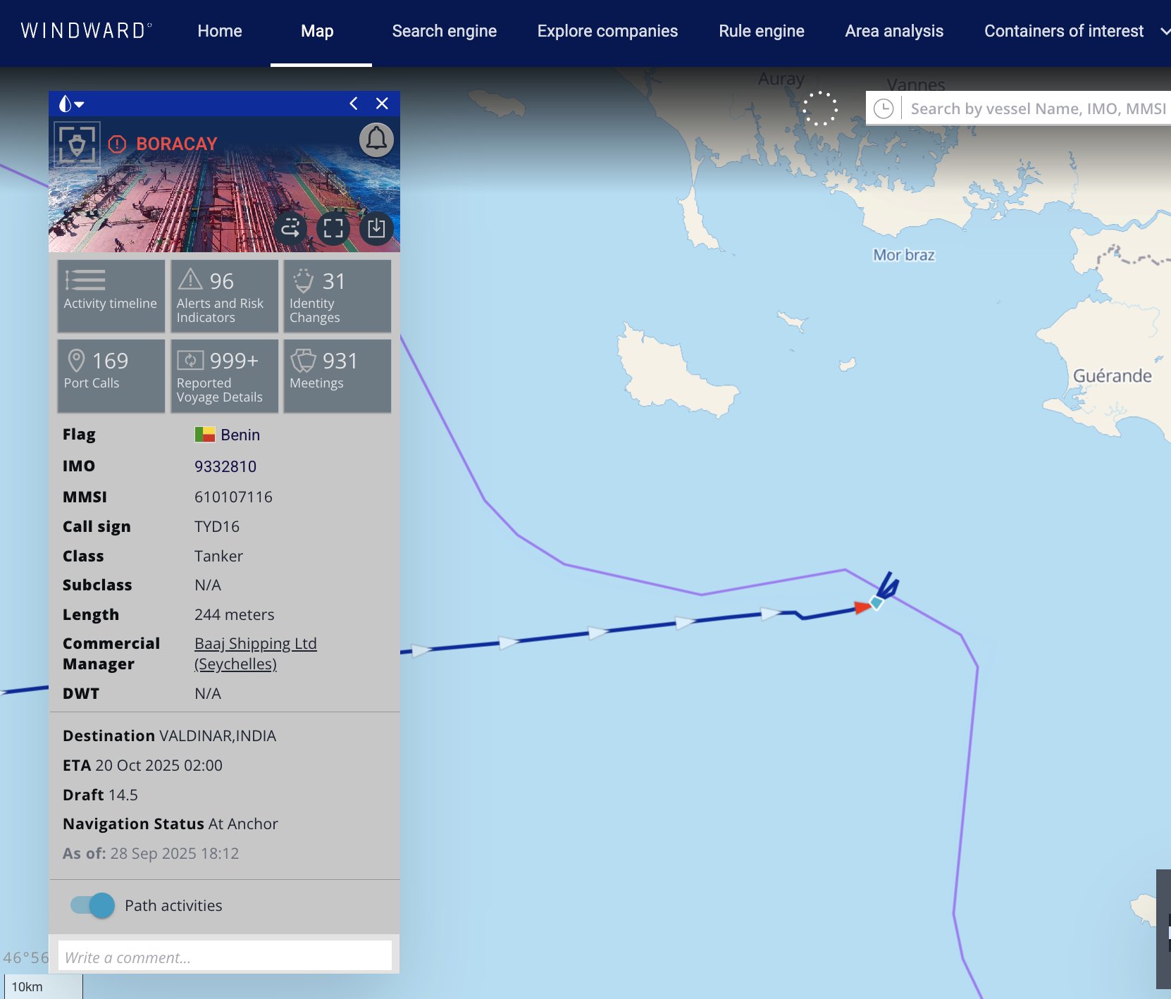
Both satellites are equipped with Galileo-enabled receivers for more accurate in-orbit positioning and carry an Automatic Identification System (AIS) payload which detects signals from ships, supporting maritime domain awareness and the detection of unauthorised activities at sea.
Sentinel-1D’s launch aboard Ariane 6 reflects Europe’s growing capacity to put its satellites into orbit on its own terms, strengthening the resilience of Copernicus Services and the EU’s strategic autonomy.
In this Observer, we look at the upcoming launch and the benefits the Sentinel-1 mission delivers.

When Sentinel-1A launched in 2014, it marked the start of routine, operational monitoring under Copernicus.
Building on Europe’s earlier SAR heritage with missions such as Envisat, it transformed access to radar data by making it routinely available on a free and open basis.
Sentinel-1’s radar sensor makes it possible to track changes to land, oceans, and ice regardless of cloud cover or darkness.
Over the past decade, this data has supported emergency responses to floods, mapped shifting coastlines, detected oil spills and illegal activities at sea, and helped monitor forests, vegetation, and agricultural activity.

As in-orbit servicing and repair are not yet a reality for most satellite missions, satellites are designed with a nominal lifetime in mind.
Sentinel-1A’s nominal lifetime was seven years, yet it has continued its mission for more than a decade.
While Sentinel-1A remains functional, Sentinel-1D will gradually assume the role of 1A in the constellation.
This will ensure the satellite mission’s full operational capacity and continuity of service, with uninterrupted radar data provision to end users worldwide.

 
This animation shows the Thwaites Glacier in Antarctica from January 2023 to 20 September 2025.
Credit: European Union, Copernicus Sentinel-1.


Eyes that never close

Unlike most high-resolution optical satellites which require daylight and clear skies to acquire usable images, Sentinel-1 satellites are equipped with a C-band Synthetic Aperture Radar (SAR) instrument, which can see through clouds, rain, and smoke, providing all-weather, day-and-night observations of the Earth’s surface.
Sentinel-1D, like its predecessors, will operate in a sun-synchronous orbit at an altitude of around 700 kilometres.
Each Sentinel-1 satellite follows a 12-day repeat cycle, meaning it retraces the same ground track every 12 days.
The effective revisit time, or the time it takes to observe the same location under any orbit pass, is much shorter because the radar instrument has a wide swath and collects data on both ascending and descending passes.
For a single satellite, the revisit time is typically around three days at the equator, about two days over Europe, and less than a day in the Arctic.
In a two-satellite configuration, the constellation achieves a six-day repeat cycle and revisit times of about a day in most regions, and even less at higher latitudes.
This means that Europe can benefit from timely, reliable observations no matter the season or the conditions on the ground.
Sentinel-1D will join Sentinel-1C, which was launched in December 2024 and is already fully operational.
Together, the two satellites will maintain the six-day revisit cycle of the Sentinel-1 mission, ensuring continuous radar coverage for Copernicus Services.
Both satellites are equipped with Galileo-enabled receivers, which make in-orbit positioning more robust and accurate.
Moreover, if GPS signals become unavailable, the satellites can continue operating independently using Galileo.
Both Sentinel-1C and Sentinel-1D carry an Automatic Identification System (AIS) payload which detects maritime vessel signals, supporting maritime domain awareness by helping to monitor ship traffic, identify dark vessels, and detect unauthorised or illegal activities at sea.

 
Revisit times for the Sentinel-1 satellite constellation in days per revisit.
Credit: European Union.


From data to operational services

Data from Sentinel-1 satellites flows directly into Copernicus Services.
It underpins the Copernicus Emergency Management Service (CEMS) for flood mapping, the Copernicus Maritime Surveillance (CMS) Service for oil spill and vessel detection, and the Copernicus Marine Service (CMEMS) for monitoring icebergs and sea ice concentration to support safe navigation.
It also supports the Copernicus Land Monitoring Service (CLMS) for vegetation, forest, and agricultural monitoring.
Notably, Sentinel-1 radar data processed with interferometry is used in the European Ground Motion Service (EGMS), part of CLMS, to detect and track ground motion from subsidence, landslides, volcanic activity and earthquakes.

Together, these services turn Sentinel-1 data into operational information which has tangible societal benefits: better disaster response, safer seas, improved land and agricultural management, and greater resilience to natural hazards.
Thanks to the open and free data policy of Copernicus, this operational information is widely accessible to public authorities, industry, researchers and service providers, who can build further applications on top of the core Copernicus products and data.
As a matter of fact, Sentinel-1 is the only satellite mission in the world which provides data on a full, free and open basis. 

A larger system built on reliable launches

Sentinel-1 is not an isolated satellite mission but part of Copernicus, the world’s most advanced Earth Observation system.
Each Sentinel satellite mission carries different instruments with complementary capabilities: Sentinel-2 delivers high-resolution multispectral imagery for land and environmental monitoring, supporting applications from agriculture and forestry to disaster mapping; Sentinel-3 carries a suite of instruments, including a radiometer for sea and land surface temperature (SLSTR), a radar altimeter (SRAL) for sea-surface height and ice topography, and an ocean and land colour instrument (OCLI), providing data on the state of the oceans, inland waters, vegetation, and the cryosphere; Sentinel-5, equipped with the Tropospheric Monitoring Instrument (TROPOMI), provides measurements of atmospheric composition, including ozone, nitrogen dioxide, carbon monoxide, methane and aerosols, supporting air quality monitoring and climate studies; and Sentinel-6, carrying the Poseidon-4 radar altimeter and a microwave radiometer, provides high-precision measurements of global sea level.
Sentinel-1, with its C-band radar, contributes a distinct capability within Copernicus, complementing the optical, ocean, and atmospheric missions by providing data that is independent of weather or daylight.

The launch of Sentinel-1D aboard Ariane 6, following the successful deployment of Sentinel-5A on Ariane 6 in August 2025, underscores Europe’s commitment to autonomous access to space.
This independence ensures that European missions can reach orbit on Europe’s terms, providing continuity of service for Copernicus users worldwide without reliance on external launch providers.
Ariane 6 also embodies Europe’s commitment to sustainability in spaceflight.
Its upper stage is designed to perform controlled de-orbit manoeuvres, preventing the creation of persistent space debris and keeping orbital pathways safe for future missions.
Even its journey to the launch site reflects this ethos, whereby Ariane 6 components are shipped across the Atlantic aboard Canopée, a purpose-built wind-powered hybrid industrial sailing vessel specifically designed to ship Ariane 6 components to the launch site while significantly reducing emissions compared to conventional transport.

By coupling mission continuity with European launch capacity, the EU strengthens the resilience of its space infrastructure.
The result is a robust, long-term system which delivers continuous, high-quality data in support of public authorities, services, science, and society at large, enabling safer communities, cleaner seas, and stronger climate preparedness.

Copernicus Sentinel-1D manoeuvred into place.
Credit: ESA.

Continuity for the next decade

Sentinel-1D is designed to operate well into the 2030s, ensuring the continuity of the Copernicus radar mission.
This confirms Europe’s commitment to open and free access to high-quality Earth Observation data which supports science, innovation, security, and climate action.

Its launch underscores the EU’s role as a leader in Earth Observation and highlights the practical value of European investment in space for safer communities, maritime security, disaster response, and long-term resilience.

On 4 November 2025 at 6:03 p.m.local time in Kourou (9:03 p.m. UTC, 10:03 p.m.CET), Sentinel-1D will lift off aboard Ariane 6 from Europe’s Spaceport in Kourou, French Guiana.
After about 30 minutes, it will be placed into orbit, ready to begin its commissioning phase, during which the radar instrument will be calibrated and validated before being declared fully operational.

Links :

Thursday, October 9, 2025

Washington secretly mapping Maduro's defences from Caribbean

 
The US special forces' mothership MV Ocean Trader and a mini submarine used by Navy SEALs for their clandestine operations off the Venezuelan coast (top right). © US Navy

 From IntelligenceOnline by Gregory Priolon
 
The US special forces' mothership, the MV Ocean Trader, has been deployed to the Caribbean. According to our sources, it is being used as a clandestine base for the operators, combat swimmers and drones that are preparing possible strikes on Venezuela's military and energy infrastructure.

Two American security sources have confirmed to Intelligence Online that the MV Ocean Trader is currently operating as a forward base for US special forces in the Caribbean, off the Venezuelan island of Margarita.
On board, teams of operators, combat swimmers and a fleet of aerial and sea drones are conducting intelligence-gathering missions, bathymetric surveys and targeted reconnaissance of Venezuela's coastal defences, offshore platforms and oil terminals.

The vessel is a former cargo carrier converted into a veritable special operations "mothership", complete with helicopter hangars, command posts and rafts for deploying fast assault craft. It serves as an ISTAR (Intelligence, Surveillance, Target Acquisition & Reconnaissance) hub.

 
Sea drones at the vanguard

Our sources say that several naval systems are deployed from the Ocean Trader.
The Sea Hunter, a large autonomous surface drone originally developed by the Defense Advanced Research Projects Agency (DARPA), and its derivative, the Seahawk, can patrol long distances to monitor shipping lanes and ports and listen to enemy electromagnetic signals.

Other more compact platforms, such as Textron Systems' Common Unmanned Surface Vehicle (CUSV), are adapted for modular missions, able to carry sonar and electro-optical sensors.
They operate alongside autonomous underwater vehicles, used to scan the seabed and create accurate bathymetric maps.

ISR and strike capabilities

According to sources close to the matter, the aerial equipment carried on the mothership combines ISR and strike capabilities, should the White House give the go-ahead.
The ScanEagle drone provides continuous surveillance over Venezuela's coast.
The RQ-21 Blackjack carries modular sensors and has increased range to cover larger portions of the Venezuelan coastline.

For close observation, teams deploy AeroVironment's Puma AE and Wasp drones, which are immediately operational to validate a landing or to confirm a target's position.
Vertical take-off and landing (VTOL) drones such as Shield AI's V-BAT take off from the deck and relay video feeds via a satellite communication system (Satcom).

Our sources told Intelligence Online that a heavy strike capability is kept in reserve: the Switchblade 600.

Combat swimmers and special units

The teams on board are part of the Naval Special Warfare Center (NSWC).
At the forefront are Navy SEALs, the US Navy's main special forces unit, who conduct coastal reconnaissance.
They operate at night, in ports and along coastlines.
Their mission is to identify, visually confirm and provide ground targeting for ISR teams.

For the most discreet infiltrations, SEAL Delivery Vehicle Teams deploy Swimmer Delivery Vehicles (SDVs) or wet submersibles.
These pocket submarines transport swimmers covertly and allow close reconnaissance without alerting Venezuelan coastal defences.
They can also be used to lay tracking beacons or passive intelligence sensors.

The presence on board of electronic warfare teams is also noteworthy, tasked in particular with detecting enemy electromagnetic signals.

Data fusion and algorithmic warfare

The on-board resources are built around data fusion technologies that are now central to US doctrine. Palantir's Foundry is cited as the key tool for aggregating data streams from aerial drones, surface and submarine drones, as well as on-board jamming and interception sensors (SIGINT).

At the same time, Auterion's Skynode provides the software layer necessary for coordinating the drones, ensuring their distributed control, resistance to jamming and the ability to operate in swarms.
Our sources call this combination of technologies a force multiplier, transforming raw data into actionable options almost instantly.

The files compiled during these bathymetric and aerial reconnaissance missions are primarily intended to reduce operational uncertainty about the real capabilities of Caracas' anti-aircraft and anti-ship defences.
The beaches being mapped, maritime approaches being analysed and oil terminals being scrutinised are all potential targets for surgical strikes or interdiction operations in the event of an escalation.

Mapping Maduro's air defences

Venezuela has built up a multi-layered air defence system, at the heart of which is Russia's S-300VM Antey-2500 system, capable of targeting aircraft and cruise missiles.
Around this core are batteries of modernised Buk-M2E (medium range), Tor-M1 and Pechora-2M systems, supplemented by ZSU and ZU-23 cannons and Igla-S Manpads deployed around the Bolivarian republic's bases and strategic sites.

This mesh is supported by multiband radars, including Russian Nebo-SVU radars, as well as several Chinese systems such as the JYL-1 and JYL-27A/YLC-18 (long range, covering the VHF and L bands), designed to detect stealth aircraft and low-altitude flights.
Sources close to the matter also mention the presence of YLC-8B radars, which specialise in detecting stealth targets.
Their integration into the Sistema Integral de Defensa Aeroespacial (SINDA) gives President Nicolas Maduro's regime expanded regional surveillance and anti-access/area denial (A2/AD) capabilities.
 
Links :

Wednesday, October 8, 2025

Nautical chart data - citizens' proposal for release fails

 In Denmark, a citizens' proposal for free nautical chart data has clearly failed.
Photo: Nico Krauss

From Yacht

In Denmark, a citizens' proposal for the free release of nautical chart data has failed by a surprisingly large margin.
50,000 signatures would have been required.

Supporters had six months to complete the Proposal "Free access to nautical chart data" ("Gratis adgang til søkortdata") online on the corresponding page of the Danish parliament.
50,000 signatures would have been needed for the Folketing to deal with the issue.
However, the initiative received very little response: 
By the deadline on Tuesday, just 1,280 signatures had been collected.
 
DGA nautical raster chart in the GeoGarage platform

"Safety and equality at sea" as justification

The anonymous initiator from Aalborg justified his citizens' proposal ("Borgerforslag") by arguing, among other things, that nautical charts are expensive and therefore not equally accessible to everyone, but at the same time "essential for safety at sea".
After all, land-related data is also freely accessible in Denmark.

It was also pointed out that the two maritime Scandinavian neighbours Norway and Sweden had already implemented similar initiatives.

Other reasons given were that high costs would also deter people interested in boating and that free information could therefore boost nautical tourism as well as the water sports industry.
For example, because harbours could provide precise information on approaches and water depths anytime and anywhere to attract guests.

Citizens' proposal not a binding instrument


The citizens' proposal is a common instrument of direct democracy in Denmark. As the name suggests, however, it is not binding for politicians.
However, if it had found the necessary 50,000 supporters, it would have been submitted as a resolution to the parliamentary process in Copenhagen, processed there and then voted on in the Folketing, although the outcome would at least have been open.
This possibility no longer exists.

Tuesday, October 7, 2025

A history of charting our nation’s waters

A NOAA survey ship uses its multibeam echo sounder to conduct hydrographic surveys.
Multibeam sonar measures the depth of the sea floor by analyzing the time it takes for sound waves to travel from a boat to the sea floor and back.


From NOAA Heritage Deep Dive Contributed by Joseph Robinson and Ashley Chappell, NOAA's National Ocean Service
 
An in-depth look back at nautical charts.
This story was originally published on NOAA's 200th Anniversary website in 2007.


A nautical chart depicts the nature and shape of the coast, water depths, and general topography of the ocean floor; locations of navigational danger; the rise and fall of tides; and locations of human-made aids to navigation.
The nautical chart is one of the most fundamental tools available to mariners, who use charts to plan voyages and navigate ships using the shortest, safest, and most economical routes.
NOAA and its predecessor agencies have been producing nautical charts for 200 years and NOAA's Office of Coast Survey continually updates its collection of over 1,000 current charts.

Since its inception in 1807, NOAA's Office of Coast Survey, or just "Coast Survey", has played a vital role in the exploration, growth, and development of the United States.
Though its activities have expanded over the past 200 years, the production of accurate nautical charts to support maritime commerce, promote safety at sea, and aid national defense has remained its core mission.

While much has changed since Congress authorized President Thomas Jefferson to create this agency, much has also remained the same.
We are still a maritime nation dependent upon waterborne trade with foreign countries; we continue to study, explore, and enjoy our coastal waterways; and we still protect our maritime borders.
Most importantly, the sea remains a dynamic and unpredictable environment, and despite our best efforts to survey and chart it, navigation retains an element of risk.
This article follows the history of nautical charting efforts within NOAA, dating back 200 years.

A Need for Nautical Charts

In early 19th century America, when the new Coast Survey began its work, shipping between the states was along the coast, which was necessary due to difficulties of transporting goods on land.
Essential foreign trade, correspondence, and diplomatic forays to Europe were accomplished completely by sea and commercial fishing was a large industry.

Despite the importance of marine navigation, few charts were available to safely guide mariners in their pursuits.
The charts that were available were old; shipwrecks were common; and “belligerent searches and seizures” by pirates, as noted in the Congressional record of the day, were a significant problem.

The British had done some coastal charting during the colonial period and during the Revolutionary War.
There were also some private charting endeavors, and various Coast Pilot series certainly were useful to mariners of the day.
However, what was truly needed was a comprehensive effort to survey our coastal waters and publish the findings.
The Coast Survey had its work cut out for it…

The Charting Begins

This early chart depicts the waters around New York Harbor.
(Image credit: NOAA)


The fledgling predecessor agency to the Office of Coast Survey began its work in earnest with network surveys in New Jersey and New York in 1816.
By 1835, hydrographic surveys to measure the depth and bottom configuration of water bodies were being conducted in the entrance to New York Harbor.
These surveys not only located dangerous submerged ledges that ships needed to avoid, but also a previously unknown deep channel that would become a main entrance into the harbor, allowing deeper draft vessels to reach the port.

Building from these first coastline surveys, work expanded along the Atlantic seaboard, creating an unbroken chain of control stations from which further surveys could be conducted.

Congress soon recognized the value of the work of the Coast Survey not only to commerce but also to national defense.
The scope of the original Congressional act that created the agency was thus broadened.
Greater resources were also made available and more responsibilities were assigned to the Coast Survey, including surveying further out from the coast.
Along with hydrographic charting, the Coast Survey also began conducting scientific studies.
These included magnetic surveys and the first major study of the Gulf Stream.

Development of an Art Form

Following the acquisition of the remainder of the Western British territories in 1846, and the addition of Texas and California after the war with Mexico in 1848, the Coast Survey was responsible for mapping nearly 54,000 miles of coastline.

This nautical chart from 1854 shows an artistic rendering of the headlands of Anacapa Island, off the coast of California.
(Image credit: NOAA)


With great attention paid to the collection of accurate data, and advances in engraving and printing techniques, these early nautical charts were of the highest caliber.
They showed not only the depths of the unseen sea floor, but often portrayed skilled artists’ renderings of important headlands and capes, as seen from a mariner’s perspective.
Topographic form and land usage were also captured with the finely engraved lines.
Examining these charts today offers a detailed glimpse into the early days of coastal communities.

The written reports and narratives by surveying officers also offer a wealth of information for today’s historians and anthropologists.
The reports included descriptions of local trade and commerce, fishing practices, port facilities, and shipwrecks.
These surveyors were explorers in every sense of the word.
Responding to the Times

As the major events of the country’s history unfolded, the need for accurate nautical charting became paramount.
The discovery of gold in 1849 increased ship traffic dramatically to and from California, and the purchase of Alaska in 1867 added another 34,000 miles to the nation’s shoreline.
During the Civil War, the Coast Survey worked actively to meet the Union’s high demand for topographic maps and charts.
After the war, the Coast Survey continued its coastal work, conducting more surveys and adding more chart coverage to its catalog.

Current events continued to direct the Coast Survey’s activities, and by the end of the 19th century and start of the 20th century, the need for charts was at an all-time high.
Once again, the discovery of gold, this time in the Klondike region of Alaska, lured many fortune-seeking travelers there by sea.
New territorial possessions acquired at the end of the Spanish-American War in the Philippines and Hawaii, and the administration of the Panama Canal Zone, added even more coastal waters to the Survey’s list of responsibilities.

During World War II, Coast Survey hydrographers, cartographers, and engravers actively supported the war effort.
For example, the USS Pathfinder, a Coast Survey ship used by the U.S.
Navy for the duration of the war, was pivotal in providing surveys and charts in the Philippines, operating in advance of fleet units.

Ultimately, the Coast Survey adopted responsibility for charting over 3.4 million square nautical miles of water and 95,000 miles of shoreline, alerting mariners to the depths and dangers along the 200-mile zone adjacent to the U.S.
coastline, an area known as the Exclusive Economic Zone.

Today’s Charts: Snapshots of Time

These three charts depict the same area near San Francisco at three different times—1859, 1974, and 2006.
Note how the charts have changed over the years.
(Image credit: NOAA)


The nautical charts of today maintain many of the same characteristics and coverage as the Coast Survey’s earlier editions.
A stroll through NOAA Coast Survey’s Historic Maps and Charts Web site offers a timeline of discovery.
Shoreline changes, coastal development, detection of new rocks and wrecks, aids to navigation modernizing over time...these nautical charts are a record of this country’s growth, snapshots showing our evolution over time.
The charts also reveal our continued dependence on marine transportation and maritime commerce 200 years later, with the growth of ports and deepening of navigation channels.

As our strongest link to the global market, our waterways now carry over 95 percent of U.S.
foreign trade tonnage each year, contributing over 13 million jobs and $742 billion to the U.S.
economy.
Commercial shipping, commercial fishing, recreational boating, tourism, national defense, emergency response, and coastal management are among the many uses dependent upon NOAA’s nautical charts.

Hydrographic surveying techniques and procedures have changed over time with evolving technology.
Multibeam sonar technology makes it possible to collect 100 percent bottom coverage of an area and creates large volumes of data.
(Image credit: NOAA)


Nautical charts are also snapshots of advancements made in surveying and mapping technology.
New data displayed on today’s charts are collected by multibeam and side scan sonar, which provide a comprehensive sweep of the sea bottom that detects obstructions.
Older charts, on the other hand, were populated with data collected from lead-line soundings or readings from casts of a weighted rope.

A nautical chart today might carry data from multiple eras, modern and old.
The 21st century chart also comes in electronic formats, to meet the needs of mariners operating with the latest technology on their ship bridges.
These electronic navigational charts enable the mariner to customize what is shown on the screen, and they deliver far more information about chart features than has ever been possible before.

Conclusion: An Important Legacy

The Coast Survey of today delivers its nautical charts motivated by the same three factors that motivated chart development 200 years ago: safety, security, and efficiency.
NOAA recognizes that U.S waterways are highways for commerce, intrinsic to maritime awareness, valuable resources for recreation, and places of environmental beauty.
Incidents like the 1989 Exxon Valdez disaster in Alaska, the 2004 Athos I strike of a submerged object in a navigation channel in Delaware, and the disarray left behind in Gulf waterways by the 2005 hurricanes demonstrate the critical vulnerabilities in our marine transportation system.
These economic and environmental tragedies are stark reminders of the hazards facing mariners navigating in U.S. waters, serving as evidence of the continued need for accurate and updated nautical charts.

Because everyone depends on safe marine transportation for something, be it the food we buy, the clothes we wear, the gas that fuels our cars, or the oil that heats our homes, NOAA’s information about the uncertain environment in which mariners must operate becomes ever more critical.

The fact that NOAA’s surveyors, hydrographers, and cartographers continue their pursuit of excellence in charting the nation’s shoreline and waters for safe and efficient marine transportation is a credit to the foresight of our founding fathers, and a reminder of how vital maritime commerce is to the United States, even 200 years later.

Links :

Monday, October 6, 2025

Ships with a possible connection to the drone saw are being investigated in France

 
The tanker Pushpa often changes its name and is also known as Boracay, Kiwala and Varuna.
Photo: Graham Flett / Marine Traffic

From NyHeder by Peter Møller , Frederikke Ingemann , Thomas Østerlin Koch & Astrid Søndberg


A ship, which according to experts could be of interest in the drone saga, is the center of a blacked-out investigation in France after an encounter with a naval vessel.

The authorities in France have started an investigation against the Russian shadow navy ship Pushpa, which moved through Danish waters during both the drone incidents at Copenhagen Airport and at military installations in Jutland.

There is a suspicion of breaking the law on the shipGuillaume Le Rasle, spokesman for the French fleet in the Atlantic

 
Guillaume Le Rasle, spokesman for the French fleet in the Atlantic, tells TV 2.
- An investigation is underway, because there is suspicion of breaking the law on the ship. The suspicion led to a notification by the prosecutor's office in Brest, which is now investigating the case, he says.

Guillaume Le Rasle cannot provide further information about the nature of the alleged offence, as the investigation is secret from the public.

 
Open Image ViewerA photo from Pushpa's deck.
The authorities in Estonia inspected the ship in April this year and found several serious faults with it. Photo: Estonian Police And Border Guard

The prosecutor's office in France confirms to TV 2 that the ship is being investigated following a report on 29 September.

Stéphane Kellenberger from the prosecutor's office in Brest announces in a written reply to TV 2 that the ship is being investigated for "lack of documentation for the ship's nationality and flag affiliation" as well as "refusal to comply with the authorities' instructions".

It has not been possible for TV 2 to get the authorities in France to state who reported the ship, whether the report comes from Denmark or another nation-state, or whether the investigation has any connection to the drone case in Denmark.

We have also asked the police in Denmark whether the French investigation is based on intelligence from Denmark, and whether it is about the drone incidents, but here they refer to the authorities in the country in which the investigation is taking place.

Stopped in the Atlantic Ocean

Pushpa is currently at anchor off the French coast after a sensational maneuver on Sunday and Monday.

The ship was actually on its way to India, but on Sunday evening it met a French naval vessel far out in the Atlantic.
Data on ship traffic shows that Pushpa was joined by a French naval vessel 100 kilometers out in international waters, just as it passed west of the large French naval port in Brest on Sunday 27 September at 15.05, Danish time.

 
Open Image ViewerThe tanker maneuvers on Saturday 27 September and Sunday 28 September.
Photo: Marine Traffic / TV 2
 
The naval vessel escorted Pushpa for at least six hours out in international waters, until Pushpa suddenly changed course and sailed into the Bay of Biscay, where the tanker stopped just outside French territorial waters west of the French city of Nantes.

Exactly how big a role the naval vessel played in the change of course is not publicly known, as the naval vessel sailed for long periods with its transponder switched off.

Thus, the naval vessel was invisible on the available data on ship traffic, and therefore there is also uncertainty about how long Pushpa was followed.

Ship data shows, however, that Pushpa has interrupted her journey, and that the ship dropped anchor approximately 40 kilometers west of the French coast on 28 September at 19:00.

 
Open Image ViewerA satellite photo reveals that Pushpa (top) was accompanied by a vessel, which does not appear on publicly available databases of ship traffic. Photo: ESA / Sentinel 2

Satellite photos confirm that the ship was in the indicated position on Monday at 13.05, and the image from space also shows that there was a larger unidentified vessel, which had its transponder switched off, approximately 1400 meters from Pushpa.

Possible military action

According to military analyst and former naval captain Jens Wenzel Kristoffersen, it is surprising that the French navy chooses to attack a ship so far out to sea in international waters.
- I can classify it as a raising of the ship. The French may have sent special forces down on it and taken over the ship. Alternatively, they may have asked them nicely to sail towards the coast and anchor there, he says to TV 2.
 
Open Image ViewerPushpa sails under the Great Belt Bridge during a visit to Denmark in July this year. Photo: Storebæltsbroen's webcam / Cristian Panton

Jacob Kaarsbo, who is a security policy analyst and former analyst in the Defense Intelligence Service, tells TV 2 that it may well look as if the French have arrested the ship.
- This is not normal. It is reasonable to believe that the French have been asked by the Danes if they want to stop the ship, he says to TV 2.

When the prosecutor's office in Brest states that the ship is being investigated for "lack of documentation for the ship's nationality and flag affiliation" as well as "refusal to comply with the authorities' instructions", according to Jacob Kaarsbo, there could easily be several factors.
- This is relatively safe for the French to say, they detain the ship on this basis, instead of responding to any Danish enquiries, he says.

Jens Wenzel Kristoffersen says that it is interesting that the French navy is suddenly interested in this particular ship, when there are so many other ships from the Russian shadow fleet that could be detained.

Was at the crime scene

According to the two analysts, Pushpa could be interesting in connection with the drone saga in Denmark, as the ship was located within flying distance of both Copenhagen Airport and several airports in Jutland, when the first drone incidents took place.

 
Open Image ViewerPushpa's position when the drone incidents took place.
You may be wondering why Russia is harassing Denmark with drones.
Take a look at the route Russian ghost fleet freighters have to take to ship out their crude oil, and you'll understand immediately why Denmark is in the Kremlin's crosshairs.
Photo: Marine Traffic / TV 2

Jens Wenzel Kristoffersen says that the case in France here can be reminiscent of the affair with the ship Eagle S, which was boarded by Finnish special forces on suspicion that it had been involved in a cable break in the Baltic Sea.

He insists that France seems to have acted in violation of international rules, if the ship has been forced onto the French coast against the captain's will, and he says that it is a decision that could potentially create a diplomatic crisis between France and the African country of Benin, whose flag Pushpa sails under.

He doubts, however, that there is any evidence left if the ship has been involved in the drone saga.
- The sea is big, and ships that do something criminal in addition to transporting sanctioned oil have ample opportunity to get rid of any evidence on the journey, so it will be interesting to hear what the French find out, he says to TV 2.

Incidentally, it is not the first time Pushpa has been detained by a NATO country, in April this year the ship was detained by the authorities in Estonia for 15 days, after it entered Estonian territorial waters.

At the time, an inspection revealed that the aging tanker had 29 serious faults, which had to be rectified before it was allowed to sail on.

 
Pushpa tanker (IMO 9332810), aka Boracay/Kiwala tanker, flying the flag of Benin, departed from the port of Primorsk (Leningrad Oblast) on Sept. 20 from Russia's so-called "Shadow Fleet," which French commandos entered on the suspicion it was a covert drone-launching ship, had zero drones, was staffed entirely by a Chinese crew, and was quietly allowed to resume its voyage...
 
Boracay was the first, but will it be the last?
As two days ago, Windward is tracking 6 falsely flagged dark fleet tankers sailing through English Channel or Atlantic to & from Russian Baltic ports.
(False flag designation is assigned by IMO).
As part of Nordic Baltic 8++ efforts to address the dark fleet, these vessels will be approached/radioed for flag/insurance & other details to ensure compliance with international maritime law (which they are clearly not). 
France, UK, Sweden, Estonia, Germany, Denmark and others will all ask the same questions.
This intelligence gathering/harrassment of this elderly, anonymously owned, poorly maintained fleet threatening the security, safety & environment of coastal states as they enjoy what’s known as the right of innocent passage under UNCLOS is so far all countries have been prepared and able to do. 
Being flagless & effectively stateless is another avenue for the Nordic Baltic 8++ to tackle the shadow fleet as demonstrated by France’s actions with Boracay.
But will countries’ navies further exercise UNCLOS Article 110 which allows for warships to deal with stateless vessels?
This is the basis I believe was likely used for the French to board & detain Boracay.
It was probably also used by Estonia in the Jaguar case in May. Unlike Jaguar, there were no nearby Russian fighter jets to fly into NATO airspace to protect Boracay & intimidate France’s navy into allowing the tanker to proceed.
Boracay departed from its anchorage off western France and is likely heading for India via the Suez Canal.
The ship’s master and first officer were returned to the vessel after earlier being detained and questioned by the French.
Prosecuters said Boracay was “considered to be an unregistered vessel under international law”. 
The captain was ordered to appear in a criminal court in Brest in February and no further legal action was taken against the first officer.
As you can see from the graphic at least three falsely flagged tankers (Maini, Sabina and Night Glory) are sailing around Britain rather than going through the Channel.
Sabina is signalling Murmansk but Maini and Night Glory (both aframaxes so more likely going to the Baltic) are possibly emulating Blue (seen at the top of Britain this morning) which is making its second voyage to the Baltic in four months by avoiding the English Channel, with extended periods of dark activity along the way that has no doubt ensured that all governments/naval eyes remain clapped on it at every stage of its voyage.
Just ending on some of Windward’s latest analysis (as of Sept 24) of the dark fleet (~1000 over 20kdwt) which is a sobering reminder of the threat falsely flagged vessels pose: nearly 2/3 Windward dark fleet over 20kdwt is sanctioned & 28% falsely flagged or flag ‘unknown’ rising to 62% of all sanctioned tankers. 
Links :

Sunday, October 5, 2025

Old Nautical Chart - La Turballe - Le Pouliguen - Pornic

1879
 
2025 nautical raster charts from SHOM in the GeoGarage platform