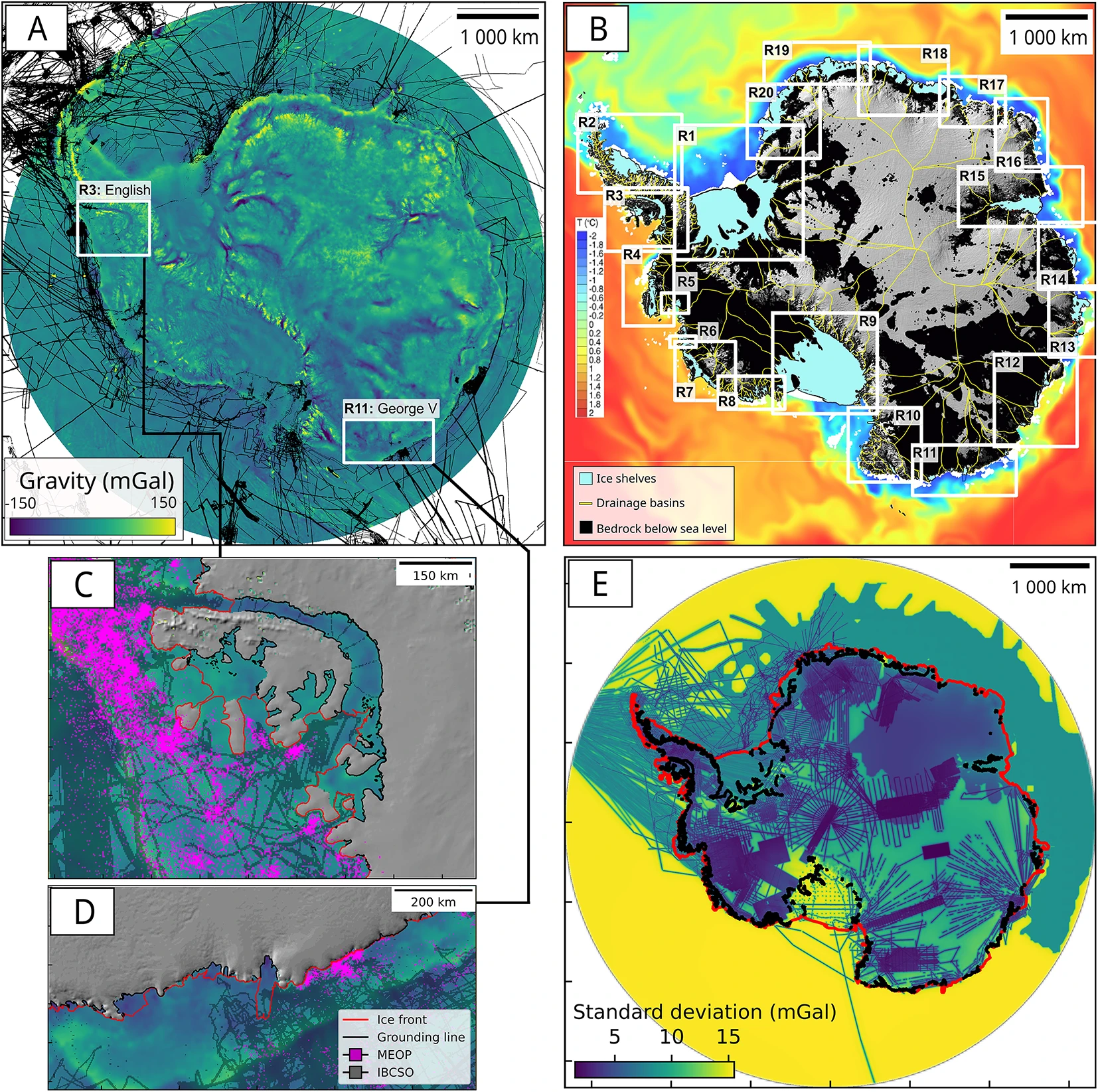
Thursday, April 10, 2025

Titanic scan reveals ground-breaking details of ship's final hours

Atlantic Productions/Magellan
 
From BBC by Rebecca Morelle & Alison Francis
 
A detailed analysis of a full-sized digital scan of the Titanic has revealed new insight into the doomed liner's final hours.
The exact 3D replica shows the violence of how the ship ripped in two as it sank after hitting an iceberg in 1912 - 1,500 people lost their lives in the disaster.
 

The digital scan shows the bow sitting upright on the sea floor
Atlantic Productions/Magellan
 
The scan provides a new view of a boiler room, confirming eye-witness accounts that engineers worked right to the end to keep the ship's lights on.
And a computer simulation also suggests that punctures in the hull the size of A4 pieces of paper led to the ship's demise.

 
Atlantic Productions/Magellan
The stern of the ship, which broke off from the bow, is heavily damaged


"Titanic is the last surviving eyewitness to the disaster, and she still has stories to tell," said Parks Stephenson, a Titanic analyst.
The scan has been studied for a new documentary by National Geographic and Atlantic Productions called Titanic: The Digital Resurrection.
The wreck, which lies 3,800m down in the icy waters of the Atlantic, was mapped using underwater robots.
More than 700,000 images, taken from every angle, were used to create the "digital twin", which was revealed exclusively to the world by BBC News in 2023.

Because the wreck is so large and lies in the gloom of the deep, exploring it with submersibles only shows tantalising snapshots.
 
This rendering of the Titanic is based on 715,000 photos and millions of laser scans of the famous wreck, which were stitched together to create a perfect digital replica of what remains of the ship.
 
The scan, however, provides the first full view of the Titanic.
The immense bow lies upright on the seafloor, almost as if the ship were continuing its voyage.
But sitting 600m away, the stern is a heap of mangled metal. The damage was caused as it slammed into the sea floor after the ship broke in half.

 
Atlantic Productions/Magellan
The glass in a porthole may have been broken as it scraped past the iceberg


The new mapping technology is providing a different way to study the ship.
"It's like a crime scene: you need to see what the evidence is, in the context of where it is," said Parks Stephenson.
"And having a comprehensive view of the entirety of the wreck site is key to understanding what happened here."

The scan shows new close-up details, including a porthole that was most likely smashed by the iceberg. It tallies with the eye-witness reports of survivors that ice came into some people's cabins during the collision.

 
Atlantic Productions/Magellan
A boiler room is at the back of the bow where the ship has split in two

Experts have been studying one of the Titanic's huge boiler rooms - it's easy to see on the scan because it sits at the rear of the bow section at the point where the ship broke in two.
Passengers said that the lights were still on as the ship plunged beneath the waves.
The digital replica shows that some of the boilers are concave, which suggests they were still operating as they were plunged into the water.
Lying on the deck of the stern, a valve has also been discovered in an open position, indicating that steam was still flowing into the electricity generating system.

This would have been thanks to a team of engineers led by Joseph Bell who stayed behind to shovel coal into the furnaces to keep the lights on.
All died in the disaster but their heroic actions saved many lives, said Parks Stephenson.
"They kept the lights and the power working to the end, to give the crew time to launch the lifeboats safely with some light instead of in absolute darkness," he told the BBC.
"They held the chaos at bay as long as possible, and all of that was kind of symbolised by this open steam valve just sitting there on the stern."

 
Atlantic Productions/Magellan
A circular valve - in the centre of this image - is in an open position


A new simulation has also provided further insights into the sinking.
It takes a detailed structural model of the ship, created from Titanic's blueprints, and also information about its speed, direction and position, to predict the damage that was caused as it hit the iceberg.
"We used advanced numerical algorithms, computational modelling and supercomputing capabilities to reconstruct the Titanic sinking," said Prof Jeom-Kee Paik, from University College London, who led the research.
The simulation shows that as the ship made only a glancing blow against the iceberg it was left with a series of punctures running in a line along a narrow section of the hull.

 
Jeom Kee-Paik/ University College London
A simulation calculated the iceberg caused a thin line of small gashes on the hull


Titanic was supposed to be unsinkable, designed to stay afloat even if four of its watertight compartments flooded.
But the simulation calculates the iceberg's damage was spread across six compartments.
"The difference between Titanic sinking and not sinking are down to the fine margins of holes about the size of a piece of paper," said Simon Benson, an associate lecturer in naval architecture at the University of Newcastle.
"But the problem is that those small holes are across a long length of the ship, so the flood water comes in slowly but surely into all of those holes, and then eventually the compartments are flooded over the top and the Titanic sinks."
Unfortunately the damage cannot be seen on the scan as the lower section of the bow is hidden beneath the sediment.

 
Atlantic Productions/Magellan

It will take many years to fully scrutinise the 3D scan
The human tragedy of the Titanic is still very much visible.
Personal possessions from the ship's passengers are scattered across the sea floor.
The scan is providing new clues about that cold night in 1912, but it will take experts years to fully scrutinise every detail of the 3D replica.
"She's only giving her stories to us a little bit at a time," said Parks Stephenson.
"Every time, she leaves us wanting for more."
 
Links :

Wednesday, April 9, 2025

Global warming is speeding up. Another reason to think about geoengineering

photograph: nasa

From The Economist

Reducing sulphur emissions saves lives.
But it could also be hastening planetary warming


Seen from afar—as it first was, by human eyes, on Christmas Eve 1968—Earth is a wonder.
When the astronauts of Apollo 8 saw their bright, cloud-girdled home rise over the barren lunar horizon they recognised at once that it was dynamic, beautiful and exceptional: something to be cared for.

But the view from space does not only inspire: it also informs.
Satellites reveal how Earth is changing, and thus what sort of care it needs.
And the latest such diagnostic information is that, although Earth remains as beautiful as ever, it has been getting a little less bright.

Satellite data show that, since the turn of the century, Earth’s albedo—the amount of incoming sunlight it reflects—has been dropping.
Because light not reflected is absorbed, that adds heat to the system and exacerbates global warming.
It is part of the reason why the rate at which the planet is warming, until the 2010s around 0.18°C a decade, now appears to be well over 0.2°C a decade.
In the decade to 2023 (admittedly a particularly hot year) it was 0.26°C.
For ecosystems under stress the rate of warming can matter a lot; for humans faster warming brings forward extremes that might not have been seen for decades.

One reason for this dimming is air pollution—or, rather, its absence.
Fossil fuels contain traces of sulphur along with the carbon and hydrogen that give them their name; the sulphur dioxide that is created when hydrocarbons burn forms tiny airborne particles that make the air smoggy.
This is deadly.
Every year global deaths from air pollution number in the millions.

Preventing sulphur emissions from getting into lungs improves people’s health, productivity and spirits.
This is why the Chinese Communist Party has been keen on such reductions.
And China’s efforts have been impressive; over the past two decades scrubbing sulphur from smoke stacks has reduced its gargantuan emissions by about 90%.
Likewise, restrictions on the sulphur content of fuel used by shipping has seen emissions on the high seas plummet since 2020.

Reducing sulphur emissions also lowers albedo.
Sulphate particles scatter light.
As a result, some of it bounces back into space.
Sulphate particles can also serve as seeds for the water droplets that make up clouds.
Fewer such seeds can make clouds less bright; sometimes clouds do not form at all.

Quite how much of Earth’s accelerated warming can be put down to the reduction in sulphur emissions is uncertain.
The workings of clouds are complex and sulphur is not the only factor at play.
But atmospheric scientists have long expected more warming when this offset is removed.
As one of the greatest of them, Paul Crutzen, wrote in 2006: “Air-pollution regulations, in combination with continued growing emissions of CO2, may bring the world closer than is realised to the danger [of catastrophic global warming].”

In his seminal paper Crutzen also noted that there was an alternative.
Particles high in the stratosphere stay aloft far longer than those close to the surface, and so provide much more cooling per tonne.
A thin layer of sulphates deliberately added to the stratosphere could provide the same amount of cooling as all the thick, polluting smogs clogging the lower atmosphere while doing much less damage to human health.
Crutzen did not advocate this.
But he did say it should be researched more vigorously, and that there might be deteriorations which warrant action.
One such, he suggested, would be seeing the rate of warming rise above 0.2°C a decade.

Since then, the amount of research into solar geoengineering with stratospheric aerosols has increased substantially.
But it remains pitifully small, in part because the experts whom governments listen to on climate and research policy are leery of it.
A report to the European Commission at the end of 2024 added to calls for a moratorium on practical steps towards it, and argued for various restrictions on research.
And it is indeed a daunting prospect, not least because it requires a high level of trust in science, a resource declining even faster than the world is warming.

Crutzen wanted swift cuts in greenhouse-gas emissions to render debates about geoengineering moot; he also feared that this was just “a pious wish”.
The world’s capacity to do without fossil fuels has increased a lot since then.
But emissions have yet to decline, and warming is speeding up.
As well as cutting emissions, governments should urgently heed Crutzen’s call for research and discuss how such powers might be used.
The message of Apollo 8 still applies; the bright, beautiful world needs to be cared for.

Links : 

Tuesday, April 8, 2025

Hitting the books: How colonialism unified the Western world's clocks

On Time: A History of Western Timekeeping by Ken Mondschein
(Copyright © 2020 Johns Hopkins University Press)


From Engaget by Andrew Tarantola 

Who needs the sun and the stars when we've got universal Newtonian time?

As ephemeral as space and as fundamental as gravity, time is an aspect of this universe that cannot be felt, only experienced through its cumulative passage.

In his latest book, On Time: A History of Western Timekeeping, author Ken Mondschein, traces society’s continued attempts at ever more accurate timekeeping — first via the observation of the stars, followed by sun dials, mechanical clocks, and onto modern atomic devices — and how the Western world would not exist in the technological state it does today without the ongoing efforts to bisect our notion of time into continually smaller, more regular intervals.
In the excerpt below, Mondschein recalls the tragedy that befell Admiral Sir Cloudesley Shovell and his 21-ship armada at the cliffs of Scilly.
But out of this loss of life came a new technology, the chronometer, which would prove vital in preventing similar future tragedies as well as helped European colonists spread both themselves and their notions of timekeeping across the world’s oceans.

Ladd Observatory collection
 
History loves winners, but sometimes it’s the losers who are more interesting.
Take, for instance, the tragedy that befell Admiral Sir Cloudesley Shovell one autumn evening in 1707 off the rocky Isles of Scilly, which lie 28 miles (45 kilometers) off Cornwall in the southwestern corner of Great Britain.
Shovell, commander in chief of the British fleet, was returning from attacking the French navy with a flotilla of 21 ships.
Though their mission had gone well, the British were beset with storms on the return voyage and went badly off course.
The standard route would have taken them past the Island of Ushant (French: Île d’Ouessant), the traditional marker for the southern end of the English Channel; through the Channel; and then up the Thames and to London.
On the night of October 22 (by the Julian calendar), Shovell and his men thought themselves safely west of Ushant.
However, owing to the foul weather — and the impossibility of determining their exact position with navigational techniques of the day — he was actually on a collision course with Scilly.
Four ships — Shovell’s flagship Association, the Eagle, the Romney, and the Firebrand — ran aground on the rocks and quickly sank.
In all, about 1,500 sailors and marines were lost, with only one crew member from the Romney and 12 from the Firebrand surviving.
The commander was among the dead: the bodies of Shovell and his two stepsons washed up on a beach some 7 miles (11 kilometers) away a day later.
 
An 18th-century engraving of the disaster, with HMS Association in the centre

This tragedy affected Great Britain in several ways.
First, Shovell was given a state burial in Westminster Abbey and treated as a national hero.
Second, as they are wont to, stories and legends grew up around the disaster.
One held that Shovell washed up alive, but a beach combing Scilly native murdered him for his emerald ring.

This might have some basis in reality, since Shovell was indeed missing his ring, but he was also highly unlikely to have survived very long in the frigid water.
Another, less likely legend is that a common sailor from Scilly warned Shovell that they were off course and would run aground, but the low-ranking mariner was ignored (or, worse, punished).
This is plainly impossible, since all hands on the Association were lost and no one could have related the tale.
But the fact that the story was considered credible shows that navigation at sea was reckoned more an art than a science — which brings us to the third, and more lasting result of the Scilly disaster: in 1714, Parliament offered a prize of £20,000 for anyone inventing a foolproof means of determining longitude at sea.
Specifically, it offered £10,000 for a method accurate to within one degree, £15,000 for 2/3 of a degree, and the full £20,000 for a method accurate to 1/2 degree.
This was an enormous sum for the time — equivalent to tens of millions of dollars in today’s money, though direct comparisons are impossible.

This princely reward was still deemed a bargain by those who offered it.
Seafaring was the lifeblood of nations in the early modern world, but it was fraught with danger.
Ships carried gold from the New World to Spain; enslaved human beings from Africa to the New World; tea and spices from Asia to England and the Netherlands; and explorers, missionaries, merchants, colonists, soldiers, and administrators to secure their mother countries’ hold on their new territories.
However, for lack of a means to precisely determine a ship’s position, sea voyages could be extended by weeks or months, dooming sailors to slow death by scurvy, starvation, or thirst as their captains searched fruitlessly for land.
This ignorance was militarily disadvantageous, as well: needing to keep to known shipping channels, Spanish galleons could easily be intercepted by British privateers.
Finally, as the case of the unfortunate Cloudesley Shovell shows, there was the ever-present danger of running aground at night or in foul weather.

The dashed blue line shows the approximate route of Shovell's fleet from Cape Spartel to the Isles of Scilly in October 1707.
The filled circle shows the estimated position on 21 October, based on observations of latitudeand soundings.
The open circle shows the dead reckoningposition of Orford when it hove to on 22 October, with the rest of the fleet, before they set off on the fatal last stage of the voyage.
The red horizontal line shows the latitude recommended by Edmond Halley as a safe northern limit for entering the channel

All of this was for sailors’ inability to determine their exact position, which requires knowing the longitude.
The means by which this technical challenge came to be solved by John Harrison, a self-educated man from an obscure background, is well known: Dava Sobel explains his invention of the chronometer thoroughly and entertainingly in her book Longitude.
(The term “chronometer,” meaning a really accurate clock suitable for navigation, was coined by the German academic Matthias Wasmuth in 1684.) I, however, think the story is more interesting if it’s told from the opposite direction — not as the heroic tale of a lone, revolutionary genius who overturned centuries of thought but as a story about hard-working experts laboring collaboratively over long years.
This is, after all, the more usual means by which scientific knowledge creeps forward.
In this case, the experts put their faith in a means of determining longitude that did not rely on tried-and-true astronomical observations — and, ultimately, they succeeded in their task.
While the myth of the lone genius is a much more appealing narrative, it is also a misleading one.
Though the chronometer represents the triumph of simplicity over complexity — and thus exemplifies our themes of precision, accuracy, and ease of use — in the end, the more informative story may not be Harrison’s but that of his great opponent, Nevil Maskelyne, who championed the more complicated astronomical “lunar-distance” system.

Section of Admiralty Chart No 34 showing the location of the HMS Association wreck on the Gilstone Rock

Despite the fact that the chronometer eventually replaced the lunar distance system, Maskelyne was influential to the history of timekeeping in a way that was arguably more important: he was instrumental in establishing Greenwich mean time as the standard against which all other times were to be compared.
The local time at sea or in part of a far-flung colonial empire wasn’t the most important time to know; rather, what was the most important was the time in an arbitrary location back in England as indicated by the face of a clock.
What’s more, this time wasn’t taken from looking at the sun or stars at whatever location you happened to be in, but rather it was an imaginary, “corrected” standard time — Newton’s absolute time made flesh.
By comparing the local time against this imaginary time, you found your position on the globe.
In short, universal Newtonian time was something European colonizers projected over the whole world.
The chronometer was a necessary device for keeping this time, but arguably, it was the mental concept that was more important.
This chapter will first look at the history of the longitude problem, followed by the controversy about how to solve it, before turning to how the Industrial Revolution incorporated this “practical Newtonianism” to regulate society and the far-reaching effects of this development the world over.
Much like ships at sea, the world of work and production for the entire human race increasingly came to be regulated by objective, independent, mechanical indicators of time that were divorced from any human perception or natural sign.
This idea of time became — albeit unevenly, with fits and starts — the time the world ran on.

Links:

Monday, April 7, 2025

Bathymetry of the Antarctic continental shelf and ice shelf cavities from circumpolar gravity anomalies and other data

Gravity data and constraints for the inversion. (A) AntGG2021 free-air gravity anomalies color coded from −150 mGal (1 Gal = 1 m/) to +150 mGal with location of MBES/SBES from6. (B) Geographic names and ocean temperature at 310-m depth from the Southern Ocean State Estimate (SOSE) model61color-coded from cold (C, blue) to warm (C, red). White areas are less than 310 m depth. Ice shelves are light blue. Bed beneath grounded ice is black if below sea level, grey otherwise. Zoom in on (C) English and (D) George V Coasts with bathymetry from MEOP41 in pink and IBCSOv2 or seismic in black. (E) Standard deviation map of free-air gravity anomalies from AntGG2021. The map is color coded from 1.5 mGal (blue) to +15.5 mGal (yellow). Standard deviations of 15 mGal indicates regions that are not covered by terrestrial gravity measurements.

Around the edges of the Antarctic ice sheet, glaciers flow into the ocean to form long floating ice shelves, which regulate the flow of ice that the ice sheet discharges into the ocean.

The increased mass loss of the Antarctic ice sheet has been attributed to the significant weakening of these floating shelves.
This weakening originates from the advection of warm, salty circumpolar waters onto the continental shelf.
These waters are then channeled beneath the shelves, where they erode the ice from below.

Although this process is well identified, the pathways of these warm waters from the abyssal plain to the grounding line remain unknown for most glaciers around the ice sheet.
This constitutes a major obstacle for models predicting the future evolution of the Antarctic ice sheet: if we do not have accurate maps of the seabed, then the models cannot correctly simulate the circulation of warm waters under the shelves, nor predict their melting appropriately.

The lack of precise measurements of the seabed topography is not accidental.
Indeed, field campaigns in this region are particularly complex and costly due to the isolation of Antarctica, extreme weather conditions, as well as the presence of icebergs and dense sea ice, which significantly limit the mobility of missions.

Moreover, the specificity of the ice shelves adds an additional difficulty: only autonomous submarines (or seismic measurements) are capable of conducting surveys there.
Thus, it is only at the cost of expensive missions that it is possible to cover tiny portions of the Antarctic seabed, although some vehicles sometimes never resurface.

However, there is an indirect method to measure the bathymetry of the seabed: the use of airborne gravimetry.
Since the gravimetric signal is proportional to the masses located beneath the gravimeter, it is possible to invert this signal and, under certain assumptions, map the bathymetry.


Bathymetry of Antarctica color coded from −1250 m (blue) to 0 m (yellow) with shaded relief for 10 regions: (A) Jebart and Fimbul (R19), (B) Borgrevink and Baudouin (R18), (C) Shirase (R17), (D) Brunt–Stancomb Wills (R20), (E) George VI (R3), (F) Abbot and Venable (R4), (G) Cook, Ninnis, Mertz (R11), (H) Moscow, Totten (R12), (I) Shackleton (R13) and (J) West (R14), with ice shelf boundary in white and inversion domains in purple.
Profiles shown in Fig. 3 are red. (K) Overview of the 10 sub-regions.
 
This approach, used by an international team including scientists from CNRS-INSU, although less accurate than direct measurements by ship, has the advantage of being conducted from an aircraft, thus allowing coverage of much larger areas.

The researchers used a unique archive of gravimetric measurements, assembled by collaborators from TU Dresden.
These data combine a wide variety of field campaigns conducted in Antarctica since the 1980s, both by aircraft, ship, but also on foot and from space.
The scientists thus collected an impressive amount of data from sonar measurements (ships), as well as CTD (Conductivity, Temperature, Depth) measurements and even probes placed on seals (see MEOP).

The results of this study reveal a new image of the Antarctic seabed.
For most of the still unknown regions, this mapping reveals seabeds with deep canyons under the shelves, but also on the continental shelf, which is the key to channeling warm waters from the abyssal plain to the glaciers.

Comparison of AntGG2021 bathymetry with other data sources along specific profiles shown in Fig. 2 for 12 regions, and Pine Island Ice Shelf in Fig. S7e. Ice is light blue, ocean is blue, bedrock is light brown, IBCSOv2 is dotted red, new bathymetry is black, and observations are thick black. CTD observations are color coded from C to C, with geographic locations in Fig. S8.
 
A comparison of this new map with ocean temperature measurements thus allows the identification of the most vulnerable sectors of the ice sheet, i.e., those directly exposed to warm waters, and those protected by shallow seabeds.

The results of this study will enable better simulation of the circulation of warm waters around Antarctica and, consequently, better modeling of the evolution of this polar ice sheet and its impact on sea level.
They have also highlighted a critical lack of data, particularly in East Antarctica, an extremely vulnerable region with significant potential for sea level rise.

Links :

Sunday, April 6, 2025

Whale cam: A day in the life of an Antarctic minke whale

Cameras attached to a rare species of Antarctic whale are giving scientists an unprecedented view of how the whales survive in their sea ice habitat. 
In a recent study, scientists attached tags to 30 Antarctic minke whales, a small and little-known species of baleen whale, to better understand the animals’ sea ice environment. 
The tags, clinging to the animals’ backs with suction cups, recorded video and motion data for 24 to 48 hours.
Some of that footage is shown here.
Each time the whales surfaced, the researchers could calculate from the video how much sea ice was present, providing clues as to how the amount and type of sea ice influenced the whales’ behavior.
Previous research had relied on satellite images to study the whales’ habitat, but scientists needed to get closer to truly understand how these creatures were moving through their sea ice environment.
While the research is still ongoing, preliminary data from the whale cams are already revealing surprising results, according to the researchers.
From the six tags analyzed so far, the researchers saw whales were spending 52 percent of their time in open water compared to just 15 percent in water with high concentrations of sea ice.
As the tagged minke whales swam and dived under the ice, the scientists also learned new things about the cryptic species and its behavior.
The piggybacking cameras allowed scientists a whale’s-eye view of a day in the life of an Antarctic minke—its feeding habits, social life, and where it spent the most time.
As Antarctic sea ice continues to shrink under climate change, understanding its importance for the whales will be crucial for protecting them, according to the researchers. 

Links :