Saturday, March 13, 2021

The story behind a lone house in the middle of Elliðaey island

The lonely house in the middle of Elliðaey island in the Southern region of Iceland
(sphoto : Little Curation )
A common sight on the internet

From Historyof Yesterday by Andrei Tapalaga

In the southern part of Iceland, there are a couple of small islands, most of them which are unpopulated, but one out of them all stands out.
The small island named Elliðaey became famous in the 21st century due to a secluded house that is located in the middle of it.
If you are old enough, you must have come across a picture of a remote house on a secluded island, many people still thinking that it is photoshopped.
 
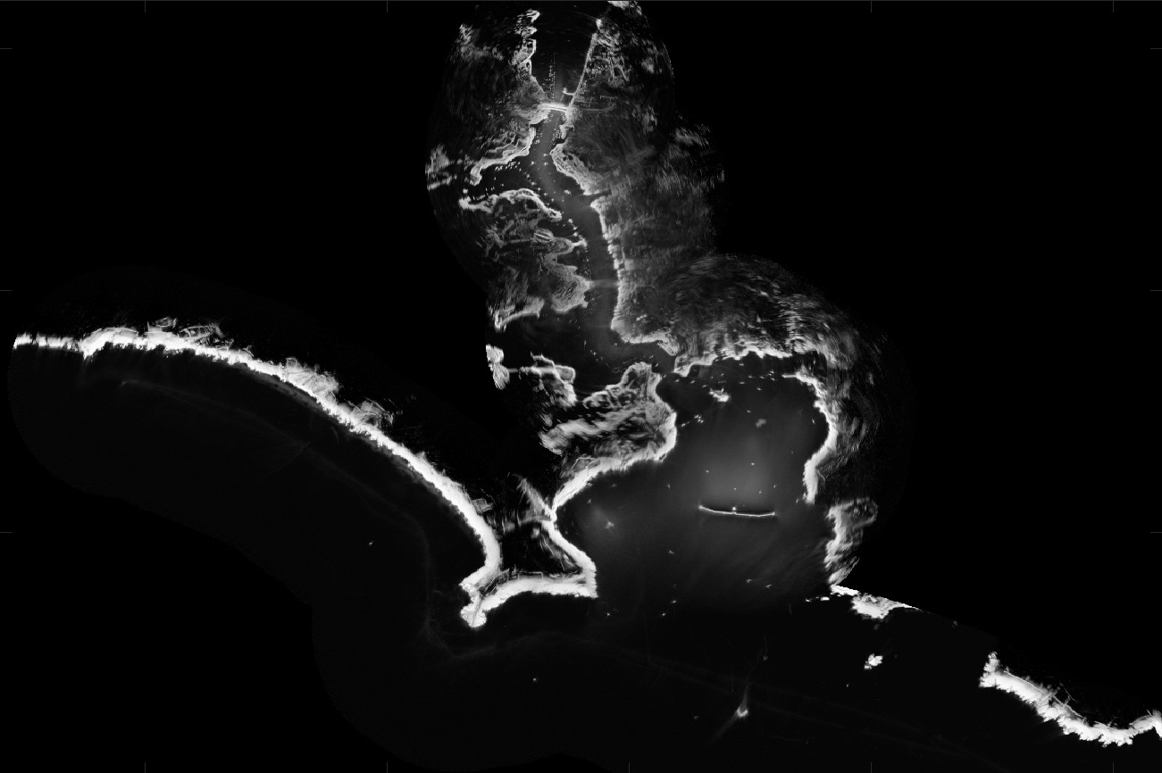
Elliðaey island with the GeoGarage platform (ICG-HD nautical charts)
 
The history behind the house

The house was built in the 1930s by five families that permanently lived on the island, surviving by hunting birds and fishing.
Not much information is known about the families that lived there in the 20th century, but surely they didn’t like to interact with outsiders.
Whilst the Vestmannaeyjar archipelago, housing 18 of such islands, is quite popular as three of its islands are populated, this wasn't the case in the early 1900s.

These islands have always been seen as the beauty of Iceland, but as they are empty with little to no vegetation nor other interesting natural architecture, the fisherman who were the only people to sight them until the 1970s would not waste their time exploring these lands.
The main picture going around the internet is similar to the first picture presented in this article which actually makes the island look very small. but that is not even half of the island.
 

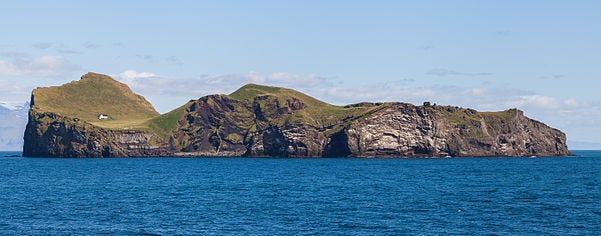
Elliðaey is part of the Vestmannaeyjar archipelago off of Iceland’s southern coast.
It is the island located furthest to the north-east among the group.
(Source: Wikipedia Commons)

The entire island is about 110 acres (0.4 squared km) and the only wildlife it houses is a nordic type of bird named puffin which is quite a delicacy.
That is why in the 1990s the empty house was adopted by local puffin hunters where they would only stay a few days until the hunt was over, sort of converting the house into a hunting-lodge.

The house does not have any electricity, nor running water, however, it has a complex system that collects rain which can be used for drinking or washing.
The house, despite its age and lack of maintenance, is in very good condition.
 
The island’s permanent population is zero and its only building is a hunting lodge built by the Elliðaey Hunting Association, which can be seen in this Overview on the northern end of the island.
Due to its unique off-the-grid location, the lodge has earned Internet fame as “the loneliest house in the world.”
geo postion : 63.465278° N, 20.175000° W
image : Maxar
 
Misconceptions about the house

There are many different misconceptions about this remote house and the island it is on.
From various stories about it being haunted to being the house of a billionaire that is waiting for the zombie apocalypse
 One of the misconceptions which actually became publicized by foreigners was that the house is owned by Bjork, a famous Icelandic singer.

This misconception actually started in the year 2000 when the contemporary Icelandic prime minister David Oddsson mentioned in one of his public speeches that he would allow Bjork to live for free on the island.
Despite all this, the famous singer never purchased the island, nor the house on it, so there is no connection.

The island, as well as the house, is still used by hunters and fisherman, but anyone can go and visit the island for no cost and even live there for a couple of days, the only thing you need is a boat to get there and some provisions if you are not willing to hunt puffins.

Friday, March 12, 2021

Port innovation from the bottom: the hydrographic (re)evolution

Bathymetric models are essential for the security of infrastructures, port operations, and vessels.
(Port of Barcelona)
 
Vector ENC chart (IHM) in the GeoGarage platform 
 
 
Knowing the details of the topography and depths of sheltered waters, dikes and approach channels of a port is essential for a good conservation and operational safety.
Ports such as Rotterdam, Hamburg, Antwerp or Barcelona have the most technologically advanced hydrographic services, capable of mapping the bottom and seeing everything that happens on the seabed Continuous innovation takes these most technologically advanced ports to the next frontier: to be able to achieve the same level of precision on the docks and on the water itself.

The most cutting-edge hydrographic services of the main international ports have technologies that generate bathymetric models obtained from the measurement of sea depths to determine the topography of the what lies on the bottom of a port. 

The most advanced systems consist of multibeam measurement that sends out hundreds of acoustic beams in a single signal that allows the hydrographer to receive more than 400 points that are measured up to ten times per second, a level of detail that is reflected in cartographic models of high resolution that describe the port seabed.
 
This information is essential for infrastructure security, port operations and for the vessels that navigate its waters.
The way to process and visualize this information collected by multibeam systems has also evolved. Nowadays, softwares allows intelligent management and screening of the thousands of bathymetric data collected during inspection campaigns and to share them with different departments in an understandable and adjusted digital format suited to the user’s needs.
 
Collecting the information
 
Ports like Barcelona carry out bathymetric surveys from a boat that incorporates a multibeam measurement system. 
To measure depth, parameters such as position must be controlled by means of GPS antennas linked to a reference station, located in the case of Barcelona in the Control Tower. Another key point is the relative position of the boat in the water, controlled by a motion sensor.
The physical conditions of the harbor waters are also analyzed during the measurements, to precisely determine the speed at which the acoustic waves travel in the water.A software collects the depth and position data that is then processed by the hydrographer.
Since it is acoustic technology, it is necessary to screen data that correspond to the rebounds that can occur and propagate in the water, something that artificial intelligence is not always capable of distinguishing.
“In terms of evolution, the algorithms that detect the bottom are becoming more efficient.
The transducers, which are the parts that send the ultrasound, generate increasingly narrow beams,” explains Elisa Palacios, Hydrographer of the Port of Barcelona.
 
Current softwares allows intelligent management and screening of thousands of bathymetric data. (Port of Barcelona)Current softwares allows intelligent management and screening of thousands of bathymetric data.
(Port of Barcelona)
 
The Port of Barcelona is also working on autonomous unmanned vehicles to carry out bathymetries in inaccessible areas, such as construction sites and areas of complex navigability.
Also, since 2018, work has been done on remote mixed solutions, where the hydrographer connects to the vessel from anywhere to control all the parameters of the bathymetric inspection, as if it were on board.
The collaboration between the Port of Barcelona and the most advanced ports in Europe is constant in this matter.
Barcelona staff have been to Rotterdam or Hamburg studying the technical and operational processes of these ports, and vice versa.
 
Data management and visualization
 
Some European ports such as Hamburg and Rotterdam, which have their own hydrographic department, generate a wealth of information from bathymetries which are complemented by additional data collected by external organizations.
All bathymetries are stored in a centralized database that is disseminated in various ways for users who need to access this information.
The data is managed using GIS software, a system that allows to collect, organize, administer, analyze, share and distribute geographic information that is also used by the Port of Barcelona.
"The management, let's call it intelligent, of the data and its storage in a database together with the records that we can exploit is the most innovative, and follows what the main European ports do," explains Miguel Ángel Cañestro, Head of Geomatic Processes of the Port of Barcelona.
A series of metadata or additional information is added to the bathymetry data to enrich and update the 3D topographic model of the bottom, such as the type of sensor used, the vessel or area explored and the hydrographer in charge.
These can then be cataloged by date, for example, where the most up-to-date data usually prevail.
 
3D topographic model. (Port de Barcelona)  
3D topographic model. (Port de Barcelona)

The activity of the aforementioned ports, for example, requires practically continuous dredging work, so one of its main users is the Construction Department and its subcontracted companies, who receive digitized graphics with the latest depth data that is essential to identify the areas in which these works must be carried out.

“Much of this information was previously delivered on paper, but the trend points towards a digital format. In Barcelona, we are going to do it through a web portal where the information will be shared with internal clients, such as the infrastructure and maritime operations departments that can view it in 2D or 3D, depending on the level of detail they require,” shares Cañestro.

As well as the seabed, technological evolution is allowing to investigate the execution of bathymetries in vertical structures and water columns 

The future doesn't stay in the seabed

This technological evolution has achieved such a level of detail that it is allowing hydrographers to go beyond mapping the bottom.
Elisa Palacios announces that the next step is to make models of the walls of the docks and dikes.

“The next evolution is to have the technology with such a level of resolution and precision that it will be allow to generate models of vertical structures, to analyze if the foundation piles of a bridge, for example, are suffering some kind of damage provoked by vessels which removes sediments near them," the hydrographer explains.
In this sense, Palacios shares that the developers of the multibeam data capture and editing software they use have requested the collaboration of her department to test the latest update of their program before releasing it to the market.
“The next thing we are going to do is acquire a new component for the multibeam system that will allow us to reach the water surface and have a model of the entire submerged part of the dock. This will be shared with the conservation department so that they can take the appropriate measures if repairs are needed,” she explains.

Another point of interest which is currently under research is the exploration of the water column and everything that causes a rebound of the acoustic signal to search for gas bubbles, fresh water emanations or floating elements which are dangerous for navigation. "
We are very close to the mouth of the Llobregat, where a lot of organic matter has been deposited and generates gas later released, so this is something that must be controlled," says Palacios.
The next revolution in port hydrography is just around the corner.

Thursday, March 11, 2021

Astronaut-explorer Richard Garriott makes record-breaking dive to deepest point on Earth


Astronaut-explorer Richard Garriott waves before entering Limiting Factor, the deep sea submersible that took him down to Challenger Deep in the Mariana Trench, the lowest point on Earth, on March 1, 2021.
Garriott is now the first person to traverse both poles, launch into Earth orbit and reach the ocean's bottom.
(Image credit: Richard Garriott)

From LiveScience by Robert Z. Pearlman

The son of a NASA astronaut and a video game pioneer who previously traversed both the North and South poles and funded his own trip to the International Space Station, Garriott completed a dive to Challenger Deep, the lowest point on Earth, on March 1.

"I am the first person to go pole to pole, space and deep and the second person — first male — to go space [to] deep," Garriott told collectSPACE in a call while still at sea on Tuesday (March 2).

Garriott, who is the incoming president of The Explorers Club, made the dive on board the "Limiting Factor," the first commercially certified, full-ocean-depth deep submergence vehicle that was developed and funded by undersea explorer Victor Vescovo.
It was aboard the same submersible with Vescovo as pilot that former NASA astronaut Kathy Sullivan became the first space traveler and first woman to dive to Challenger Deep — in August 2020.

Like Sullivan, Garriott made the trip as part of a series of dives aimed at surveying the Mariana Trench and collecting scientific samples.
Garriott, together with his friend Michael Dubno (who was mid-dive when Garriott called from the surface support ship, the "Pressure Drop"), also brought along their own set of engineering and artistic experiments for the journey.

collectSPACE.com spoke with Garriott about his record-setting dive and the similarities it shared with his other adventures around, and off, the world.
This interview has been edited for length and clarity.

collectSPACE (cS): Though certainly the deepest, this was not your first dive.
How did the four-hour descent to Challenger Deep compare to some of your other dives, such as to the Titanic and to hydrothermal vents aboard the Russian-built Mir submersibles?


Richard Garriott: What's interesting about Limiting Factor is that it's going to more than twice the depth than I'd ever been previously and, as it turns out, that is mightily more difficult.
To find equipment that can operate at half that depth is already virtually non-existent.
So to find or create equipment that can operate at double that depth is even harder.
They have had to overcome some amazing engineering problems, starting with just how to keep the passengers alive.

The 9-centimeter-thick (3.5-inch) titanium hull is the smallest vehicle I've ever been in, although it felt roomier than a Soyuz [Russian spacecraft] because there is less people and material on the inside.
So you actually feel very comfortable, but the interior diameter only starts at about 1.46 meters (4.79 feet) and shrinks to about 1.4 meters (4.59 feet) as the pressure builds on the outside.

Richard Garriott's view while seated in the Limiting Factor for the dive to Challenger Deep on March 1, 2021. (Image credit: Richard Garriott)

The temperature also goes from quite warm on the surface here in the tropics [near Guam] to just right about freezing as you get down into the depths.
It gets colder and colder.

The light disappears almost immediately.
Most other submarines in the world operate within a few hundred meters of the surface where there is generally still a little bit of light still available.
This one is descending so fast and so far that it becomes truly pitch black outside the viewport mere moments after you depart and so you're falling through the inky blackness for most of the four-hour descent.

Richard Garriott will dive aboard Caladan Oceanic's "Limiting Factor," the first commercially certified full-ocean-depth deep submergence vehicle. (Image credit: Caladan Oceanic)

cS: During the descent, do you just sit there for four hours? Is there something to do? Do you take a nap?

Garriott: I had taken with me a lot of things that I wanted to do on the interior [of the submsersible] associated with the outreach that I was doing with the schools across the U.S.
and even more in the UK.
Whether it was photography as part of a project that students were working on in concert with the company Canon or sharing and filming some of the artwork that school kids had created, or reading some poetry the kids had had written specifically for this challenge, that kept me busy for the downward journey and the upward journey.

In fact, let me just mention something about the poetry, just because I think it was the one [activity] for me that was the most surprising.

It's really common to decorate [and dive down with] styrofoam cups to show how they get compressed [by the pressure] in the depths because it is a fun little keepsake, but it was a gentleman from the National Organization for Teaching English that came up with a challenge for students that basically said to stay alive and do work at this depths in the ocean, the developers of the submarine and the scientists on board have to take only the minimum number of things with them on the interior, things absolutely needed for life support and for experiments.

The challenge to the kids was to write a poem called a cinquain, a five line poem of 22 total syllables, where the you're only allowed two, four, six, eight and two syllables per line.
So when you're going to write a poem about how to dive down to the deepest point of the ocean, you have to choose not only every word, but frankly, every syllable very carefully.

It turned out that was super popular for people to get involved in.
Not only did kids across all of the UK schools submit really clever poems, but as soon as people on Twitter started hearing about it, I started hearing back from students across almost every continent on Earth.
And I started hearing from relatives I didn't even know I had from various parts of the country.
All of them wanted a chance to participate.

Richard Garriott's view of the abyssal plain, the silt-blanketed floor of the ocean in the Mariana Trench.
(Image credit: Richard Garriott)

Even my own kids and family got involved in writing these.
And I wrote a few myself and even Victor Vescovo, the submarine developer and pilot, who was with me, he was enjoying these so much, he wrote one on the spot.
He wrote one down in the Challenger Deep at the bottom and recited it for the kids from there at the bottom, too.

That kept us busy for what otherwise could have been long spans of time on the descent and ascent.
Reading poetry turned out to be just big fun and much more interesting than I expected.
So there was very little time to rest or be bored.
Traditionally everyone takes a movie for the way up.
My selection was "Das Boot," the German submarine warfare movie, but we only watched an hour of it because we were still so busy doing other activities.

cS: What did you see and do when reached the deep, the bottom of the ocean?


Garriott: Our dive plan was to drop down first right into the deepest part of the eastern pool, which is the deepest part of the Mariana Trench, just to check off the box that we had reached the deepest point and to leave a geocache, which we did.

We left behind a 6-inch-square [15 cm] titanium plate connected to a 6-foot [1.8 m] line of Kevlar with a syntactic foam float.
On all sides of the float and all sides of the titanium is the geocache numerical identifier and a secret word.
The reason for the secret word is so that the only people who will be allowed to claim that they've been the ones to find it are those who know the secret word, ensuring that they've actually visited.
Advertisement

So we successfully deployed [the geocache] in the center of the deepest point on Earth and then we cruised for about an hour across the sea floor.

The sea floor down there, right where you land, is what I'm describing as the 'abyssal plain.' It's a desert of sorts.
The bottom condition is both flat and has a very silty, murky bottom where the detritus from life seven miles [11 km] above it in the water column — whether it's scales or dirt or dust or the rotting corpses of fish above — sort of slowly all rains and settles down here at the bottom.
While at some point down below us you would get into what you might traditionally call mud, the actual entire surface is covered with maybe a foot thick [0.3 m] of this talcum powder fluff that is more like what you might imagine, or you might've seen in a Build-A-Bear Workshop where they have the fluff they shove into stuffed toys.

There's not really even a surface that looks particularly hard.
It is very, very, very, very delicate.
But there's actually quite a bit of life down there.
We saw almost every few feet or at least every dozen feet, one of these almost translucent crustaceans of a few inches long that would scoot around all over the bottom to make a meager existence out of the tiny amount of organic matter that makes it down there for food.

Large rocks from where the Pacific plate is being subducted by the Philippine Sea plate, forming the Mariana Trench, protrude from the silt-covered ocean floor.
(Image credit: Richard Garriott)

Then, as we crossed this abyssal plain, we actually ran into our first bit of humanity, which was a 7-mile-long [11 km] cable that had been previously attached to a remotely-operated vehicle.
It's worth noting that last summer when Victor was down here, this was not there.
And between that visit and our visits, a Chinese crew had been out here with both one free diving submersible and one remotely operated vehicle, the latter to photograph the submarine.

It's a fairly common practice for those who use these extremely long tethers to jettison it and the problem with that is it creates an incredibly difficult hazard for submarines because it's 7 miles long and loops and curls all over the sea floor and you can't see it until you're really in it.
We saw it first crossing our paths in one direction and we were shocked to see it, a little bit alarmed and concerned.
Then we saw the same cable, or presumably the same cable again, crossing our path the other direction.

cS: Before you dove, you said you had intentions to try to collect geological samples from where the Pacific plate is being subducted below the Philippine Sea plate (which is why the Mariana Trench exists).
Were you successful?


Garriott: We were unable to get a rock back.
We were having both some electrical problems and, unrelated, we were having some trouble with the manipulator arm.
It turned out to be a software glitch.
And then there was the condition of the rocks.

Even though we were in the rockfall, all the rocks that we could see were still covered in this very deep murky soup that I described.
Only little corners of large rocks stuck out and we really needed to find one that was small enough for the manipulator arm to pick up.
Because of the covering of fluff, we couldn't see the small rocks, much less reach in to pick them up.
If you came close to this murky bottom, you get browned out by the kicking up of that silt that might take hours to settle again.
And so we were unable to get a rock.
That is a task we will leave to the next explorers.

cS: One of your personal projects was to try to use the pressure outside of the submersible to hydroform, or mint, tokens.
How did that go?


Garriott: Oh, yes! We made a double-sided die with 18 bolts or so around a ring to clamp on metal plates to try to hydroform.
The side that we put copper on did perfectly.
It actually is a marvelous little, three-inch [7.6 cm] impression that was made across the die.

What's interesting is that there were still some air pockets below that copper plate, which means that a millimeter or two of copper is technically enough to where if you were to drill a hole in the side of the submarine — which you do not do — but if you did and covered it with even just a thin copper plate, it would bow into that quarter-inch [0.6 cm] hole, but wouldn't break, it wouldn't pop.

It's actually fascinating that on the one hand, this depth and pressure is awesome to try to think about how to build equipment to survive within it.
On the other hand, it's similarly awesome just how a simple experiment like hydroforming can show that even a thin sheet of metal, if it's supported in the right way, will not break and still resist that amazing pressure.

The other side of the die we had made with brass and the brass stayed stiffened straight up until water managed to encroach on the sides and fill the other half of the die.
So we've added a little special lubricant that they use on the hatches that helps seal from water.
We'll see if that works.Richard Garriott's selfie aboard the Limiting Factor submersible, which took him to the lowest point on Earth, Challenger Deep in the Mariana Trench, on March 1, 2021.

Garriott is now the first person to traverse both poles, launch into Earth orbit and reach the ocean's bottom.
(Image credit: Richard Garriott)

cS: So now that you've conquered the deep, how would you compare it to your past adventures? Does one top the others or how would you rank them?

Garriott: Well, space will be hard to beat, so space still wins.
But the one thing that all of the locations share is that when you go to someplace that's this extreme, the laws of physics really do seem to change profoundly.

In space, the obvious one is floating around 24/7.
Not feeling gravity is obviously a fundamental change in the physics associated with your life.

In Antarctica, it's the complete lack of being able to tell distance because there's no specular hazing, there's nothing like roads or telephone poles to give you a sense of perspective.
And so large rocks far away and small rocks close up look the same.
It's a fascinating place to be because of how sight and sound works and the same is now true for these incredible depths where you can measure the hull being crushed around you.

I took a digital tape measure and the submarine shrunk by 6 millimeters [0.2 inches] as went down to the depths.
The pressure was so great that even things like the acoustic phones, which were made for communicating underwater, barely work at those depths.

Water is non-compressible but in fact it does compress at least a little.
The density of the water becomes greater and greater at these enormous depths.
Our descent rate at the beginning was a couple of meters per second, but by the time we got to the bottom, the water itself became so dense that we slowed down to under a half a meter per second, just because we were almost becoming neutrally buoyant at the bottom, despite the fact that we were getting smaller by being crushed.

Links : 


Wednesday, March 10, 2021

Atlantic Ocean circulation at weakest in a millennium, say scientists


From The Guardian by Fiona Harvey

Decline in system underpinning Gulf Stream could lead to more extreme weather in Europe and higher sea levels on US east coast

The Atlantic Ocean circulation that underpins the Gulf Stream, the weather system that brings warm and mild weather to Europe, is at its weakest in more than a millennium, and climate breakdown is the probable cause, according to new data.

Further weakening of the Atlantic Meridional Overturning Circulation (AMOC) could result in more storms battering the UK, more intense winters and an increase in damaging heatwaves and droughts across Europe.

Scientists predict that the AMOC will weaken further if global heating continues, and could reduce by about 34% to 45% by the end of this century, which could bring us close to a “tipping point” at which the system could become irrevocably unstable.
A weakened Gulf Stream would also raise sea levels on the Atlantic coast of the US, with potentially disastrous consequences.
 

Stefan Rahmstorf, of the Potsdam Institute for Climate Impact Research, who co-authored the study published on Thursday in Nature Geoscience, told the Guardian that a weakening AMOC would increase the number and severity of storms hitting Britain, and bring more heatwaves to Europe.

He said the circulation had already slowed by about 15%, and the impacts were being seen.
“In 20 to 30 years it is likely to weaken further, and that will inevitably influence our weather, so we would see an increase in storms and heatwaves in Europe, and sea level rises on the east coast of the US,” he said.

Rahmstorf and scientists from Maynooth University in Ireland and University College London in the UK concluded that the current weakening had not been seen over at least the last 1,000 years, after studying sediments, Greenland ice cores and other proxy data that revealed past weather patterns over that time.
The AMOC has only been measured directly since 2004.

The AMOC is one of the world’s biggest ocean circulation systems, carrying warm surface water from the Gulf of Mexico towards the north Atlantic, where it cools and becomes saltier until it sinks north of Iceland, which in turn pulls more warm water from the Caribbean.
This circulation is accompanied by winds that also help to bring mild and wet weather to Ireland, the UK and other parts of western Europe.

These data consistently show an AMOC decline in the 20th Century, with the weakest AMOC state of the whole series in the last decades.

Scientists have long predicted a weakening of the AMOC as a result of global heating, and have raised concerns that it could collapse altogether.
The new study found that any such point was likely to be decades away, but that continued high greenhouse gas emissions would bring it closer.

Rahmstorf said: “We risk triggering [a tipping point] in this century, and the circulation would spin down within the next century.
It is extremely unlikely that we have already triggered it, but if we do not stop global warming, it is increasingly likely that we will trigger it.
“The consequences of this are so massive that even a 10% chance of triggering a breakdown would be an unacceptable risk.”

Research in 2018 also showed a weakening of the AMOC, but the paper in Nature Geoscience says this was unprecedented over the last millennium, a clear indication that human actions are to blame.
Scientists have previously said a weakening of the Gulf Stream could cause freezing winters in western Europe and unprecedented changes across the Atlantic.

The AMOC is a large part of the Gulf Stream, often described as the “conveyor belt” that brings warm water from the equator.
But the bigger weather system would not break down entirely if the ocean circulation became unstable, because winds also play a key role.
The circulation has broken down before, in different circumstances, for instance at the end of the last ice age.

The Gulf Stream is separate from the jet stream that has helped to bring extreme weather to the northern hemisphere in recent weeks, though like the jet stream it is also affected by the rising temperatures in the Arctic.
Normally, the very cold temperatures over the Arctic create a polar vortex that keeps a steady jet stream of air currents keeping that cold air in place.
But higher temperatures over the Arctic have resulted in a weak and wandering jet stream, which has helped cold weather to spread much further south in some cases, while bringing warmer weather further north in others, contributing to the extremes in weather seen in the UK, Europe and the US in recent weeks.

Similarly, the Gulf Stream is affected by the melting of Arctic ice, which dumps large quantities of cold water to the south of Greenland, disrupting the flow of the AMOC.
The impacts of variations in the Gulf Stream are seen over much longer periods than variations in the jet stream, but will also bring more extreme weather as the climate warms.


As well as causing more extreme weather across Europe and the east coast of the US, the weakening of the AMOC could have severe consequences for Atlantic marine ecosystems, disrupting fish populations and other marine life.

Andrew Meijers, the deputy science leader of polar oceans at British Antarctic Survey, who was not involved in the study, said: “The AMOC has a profound influence on global climate, particularly in North America and Europe, so this evidence of an ongoing weakening of the circulation is critical new evidence for the interpretation of future projections of regional and global climate.

“The AMOC is frequently modelled as having a tipping point below some circulation strength, a point at which the relatively stable overturning circulation becomes unstable or even collapses.
The ongoing weakening of the overturning means we risk finding that point, which would have profound and likely irreversible impacts on the climate.”

Karsten Haustein, of the Climate Services Center in Germany, also independent of the study, said the US could be at risk of stronger hurricanes as a result of the Gulf Stream’s weakening.

“While the AMOC won’t collapse any time soon, the authors warn that the current could become unstable by the end of this century if warming continues unabated,” he said.
“It has already been increasing the risk for stronger hurricanes at the US east coast due to warmer ocean waters, as well as potentially altering circulation patterns over western Europe.”

Dr Levke Caesar, of Maynooth University in Ireland, and the lead author of the paper, said sea level rises on the east coast of the US were another potential consequence.
“The northward surface flow of the AMOC leads to a deflection of water masses to the right, away from the US east coast.
This is due to Earth’s rotation that diverts moving objects such as currents to the right in the northern hemisphere and to the left in the southern hemisphere,” she said.
“As the current slows down, this effect weakens and more water can pile up at the US east coast, leading to an enhanced sea level rise.”

Links :

Tuesday, March 9, 2021

HMS Magpie tests groundbreaking software to rapidly map the seabed

Radar shoreline map of Plymouth Sound, 
a byproduct of the software used for the survey (Royal Navy)

 View of Plymouth Sound with the GeoGarage platform (UKHO raster map)

From Royal Navy

The Royal Navy has tested cutting-edge software to map the seabed close to shore in hours – not days or weeks.

Survey vessel HMS Magpie was able to chart the waters around Plymouth purely using regular radar installed on shipping the world over and a specialist computer program which measures wave height.

Using that data and information about currents, the software can produce a detailed profile of the seabed in a matter of hours – without the ship or boat having to physically sail over the area being surveyed.

All the system needs is wind and a swell to generate waves – plus computing power.
 
HMS Magpie off Portsmouth (Royal Navy)

It is not as detailed as the scans Magpie or other Royal Navy survey vessels can produce with their hi-tech sonar suites – and it only works close to shore.

But the method – known as radar bathymetry and developed by scientists from the National Oceanography Centre in Liverpool and MOD experts from Defence Science and Technology Laboratory – could be vital in times of peace or war when time is critical.
 

“By analysing the sea clutter images of waves visible on standard marine radars a bathymetric profile (that's the depth) and surface current assessment is created,” explained the lead project scientist at the National Oceanography Centre, Paul Bell.
“This technique could allow the remote charting of both shallow water and currents from a standoff distance of several nautical miles and could be employed by all Royal Navy Ships using the navigation radars that are already fitted with.”

Given her size, Magpie doesn’t carry the standard navigational radar used by the rest of the Fleet, so one was temporarily installed on a roof rack.

It would take the ship perhaps a fortnight to map the ocean floor on the approaches to Plymouth naval base and the Sound with her sonar.
It took the software just hours to do the same – and one by-product was an accurate composite map of the area’s coastline.

Time could be the difference between life and death in the aftermath of a natural disaster with a possible shifting seabed preventing the usual access to harbours or beaches or an amphibious landing on or evacuation from poorly/uncharted shores.

At present the software is still in development, but the goal is to integrate it with the Royal Navy’s existing navigational radar and systems – no new equipment would be required in most cases, just upgraded software – to provide accurate, real-time seabed maps.

“The Royal Navy is continually looking to employ new up-to-date technologies,” said Lieutenant Commander Mark White, HMS Magpie’s Commanding Officer.
“The beauty of this concept is that it uses the existing radars already fitted to our ships.
“It was excellent to work alongside the National Oceanography Centre to trial and develop these new and exciting techniques that could have a wide range of use in the Royal Navy.”

More regular duties are in store for Magpie shortly.
Having just emerged from her annual winter overhaul, the ship is due to head up the East Coast to conduct traditional survey work of ports and harbours.

Monday, March 8, 2021

SailGrib Android mobile app & GeoGarage


SailGrib Android on GooglePlay

SailGrib (version 6.0, March 8th) is compatible with the GeoGarage nautical chart platform


Tutorial (in English)

see SailGrib FAQ :  FR / US
Note : Weather4D R&N iOS users already having a GeoGarage account can use their GeoGarage account with SailGrib Android, and vice-versa

Norse goddess reveals seabed secrets


From NIWA

A large, orange Scandinavian robot gives NIWA’s marine geologists an in-depth look at changes to the seafloor off Kaikōura.

The 2016 earthquake left an all-too-visible trail of destruction across Kaikōura’s landscape.
Buildings were shattered, road and rail links severed, and massive scars cut across hillsides and coastal terraces alike.

What wasn’t so immediately obvious was the impact the 7.8 magnitude quake had on the deep underwater canyon just hundreds of metres off the coast.

 localization with the GeoGarage platform (Linz nautical raster chart)
 
The Kaikōura Canyon starts less than a kilometre out from land, as the seabed plunges to depths of more than 600m, and eventually to 2000m, creating a formation of channels and ravines which fan 60km out into the Pacific Ocean.

Cold currents rising from the deep bring nutrient-rich waters into the canyon system, helping to create a uniquely productive habitat nourishing organisms ranging from small seafloor invertebrates through to the region’s iconic dolphins and whales.

Marine geoscientist Dr Joshu Mountjoy describes the canyon as the bridge between the land and the ocean, connecting sedimentary systems, capturing carbon and supporting rich ecosystems.

Multibeam seabed surveys carried out by NIWA’s research vessels Tangaroa and Ikatere after the 2016 quake revealed dramatic changes.
Huge amounts of mud and sediment, estimated at 850 million tonnes, were shaken from the canyon rim, flowing down the underwater channels and out into the Pacific.


The AUV’s high resolution mapping technology reveals huge boulder ridges running across the seafloor more than a kilometre below the surface.

This massive submarine sediment flow, tracked at least 700km to the north, instantly turned the canyon floor from a biodiversity hotspot full of marine life into a barren, almost uninhabited seascape.

Late last year Mountjoy led another team of researchers back to the waters off the Kaikōura coast aboard Tangaroa.

“We were interested in understanding the physical process that had removed such a huge amount of sediment and rock from the canyon. It was also a chance to establish how the ecosystems were recovering after such a major event, and measure the amount of sediment re-entering the canyon,” Mountjoy says.
“Although we had done surveys before, we now needed a way to capture the extent of the post-earthquake changes at a much higher resolution.”

To get such a detailed picture of conditions almost two kilometres under the surface, Mountjoy recruited the help of the European marine research alliance, Eurofleets+. NIWA is the only southern hemisphere member of this 27-country alliance.

In October, Rán, a 6.5m autonomous underwater vehicle named after the Norse goddess of the sea, arrived in Wellington on loan from Sweden’s Gothenburg University.


Technicians reprogramme Rán as the AUV prepares for its next mapping mission off the Kaikōura coast.
[Photo: Lana Young, NIWA]

Fully equipped with its own suite of sensors for remotely scanning the seafloor and monitoring oceanographic conditions, Rán was also accompanied by two European technicians who both had to undergo full quarantine procedures prior to joining the voyage.

Pre-programmed and deployed from the stern of Tangaroa, Rán descended to the depths of the canyon floor, operating for up to 29 hours before needing to return to the research vessel.

It is the first time this type of technology has been used in New Zealand waters, and sweeping as low as 20m above the seabed, the AUV was able to map the entire canyon floor at resolutions 25 times higher than earlier surveys.

During Tangaroa’s research voyage, Rán completed a total of 14 dives, surveyed over 2,000km of seafloor at an average speed of 7km/h, and acquired a staggering 1.6 billion datapoints.

“The data has given us unprecedented insight into how submarine canyons are created,” says Mountjoy.
“The mid-lower canyon is dominated by giant gravel waves that are carving out the bedrock.
“We already knew that dunes 20m high and 200m across had shifted 500m down the canyon. But the data collected by the AUV now shows that these dunes are made of boulders up to 7m across."
“It is hard to imagine how much power is required to move rocks of that size, but that’s exactly what has happened in that area.”

The research team are currently working their way through the detailed data files recovered during Rán’s successful mission – a high-resolution treasure trove which Mountjoy believes will lead to a clearer international understanding of post-earthquake continental shelf processes.

Links :

Sunday, March 7, 2021

Walker 'stunned' to see ship hovering high above sea off Cornwall

  A tanker appears to hover high above the surface of the sea off the Cornish coast. Photograph: David Morris/Apex

From The Guardian by Ian Sample

David Morris encounters rare optical illusion known as superior mirage while out on coastal stroll


There are only so many polite words that come to mind when one spots a ship apparently hovering above the ocean during a stroll along the English coastline.

David Morris, who captured the extraordinary sight on camera, declared himself “stunned” when he noticed a giant tanker floating above the water as he looked out to sea from a hamlet near Falmouth in Cornwall.

The effect is an example of an optical illusion known as a superior mirage.Such illusions are reasonably common in the Arctic but can also happen in UK winters when the atmospheric conditions are right, though they are very rare.

The illusion is caused by a meteorological phenomenon called a temperature inversion.
Normally, the air temperature drops with increasing altitude, making mountaintops colder than the foothills.
But in a temperature inversion, warm air sits on top of a band of colder air, playing havoc with our visual perception.
The inversion in Cornwall was caused by chilly air lying over the relatively cold sea with warmer air above.
 
Warm air over cold water can produce a 'superior' mirage
Guardian graphic. Source HyperPhysics, Georgia State University.
Note : vertical scale exaggerated
 
Because cold air is denser than warm air, it has a higher refractive index.
In the case of the “hovering ship”, this means light rays coming from the ship are bent downwards as it passes through the colder air, to observers on the shoreline.
This makes the ship appear in a higher position than it really is – in this instance, above the sea surface.

“Superior mirages occur because of the weather condition known as a temperature inversion, where cold air lies close to the sea with warmer air above it,” said David Braine, a BBC meteorologist. 
“Since cold air is denser than warm air, it bends light towards the eyes of someone standing on the ground or on the coast, changing how a distant object appears.”
He added: “Superior mirages can produce a few different types of images – here a distant ship appears to float high above its actual position, but sometimes an object below the horizon can become visible.”

Photographers around the world have captured striking images of ships, yachts and other vessels apparently hovering in mid-air thanks to superior mirages.
One potential clue that the sight is a mirage is the lack of any detail below the vessel’s waterline – for example a mirage of a “hovering” yacht lacked the lower hull and keel.

The latter effect is well known to sailors who can sometimes rely on refraction to spot ships that are geometrically beyond the horizon.
Sailors say such ships are “looming” over the horizon and sometimes report distortions that stretch or compress the images, making them “towering” or “stooping” mirages, respectively.

More familiar optical illusions are the “inferior mirages” that give rise to apparent oases in the desert and puddles on hot summer roads.
These mirages happen when cooler air sits on a layer of hot air, directly above a road, for example. When sunlight coming down from the sky approaches the air near the hot surface, it is bent back upwards to the observer’s eye, making the sky appear to be reflected on the road.

Links :