
61 sediment cores up to ~5.5 m long were collected from sites on the
continental margin
between the Kaikoura coast and Poverty Bay. [NIWA]
From NIWA
Scientists surveying the seabed in areas affected by
last week’s earthquake have confirmed a 34km rupture in the offshore
continuation of the Kekerengu Fault, known as the Needles Fault.
NIWA’s flagship research vessel returned to port in Wellington today
after a two-week voyage, initially to undertake seismological research
on the Hikurangi subduction zone, off the North Island’s East Coast
which is regarded as New Zealand’s largest earthquake and tsunami
hazard.However, with several leading marine geologists on board, it was decided to divert the ship to take core samples and survey the seabed in areas affected by the Mw 7.8 earthquake.

Hikurangi Trench on a Linz nautical chart (GeoGarage platform)
New mapping and profiling confirmed that the Needles Fault ruptured
Voyage leader and NIWA marine geologist Dr Philip Barnes said today new mapping and profiling confirmed that the Needles Fault ruptured forming newly discovered scarps on the seafloor along the Marlborough coast south of Cape Campbell.
Dr Barnes said the length of the Kekerengu-Needles fault rupture may now extend for about 70km – 36km on land and 34km under the sea.

New mapping and profiling confirmed that the Needles Fault ruptured
forming newly discovered scarps on the seafloor along the Marlborough
coast south of Cape Campbell. [NIWA]
61 sediment cores collected
Scientists collected 61 sediment cores, each about 5.5m long from sites on the continental margin between the Kaikoura coast and Poverty Bay that will provide evidence of submarine landslides.
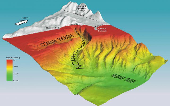
3D visual of the Kaikoura Canyon's submarine topography
courtesy of NZHerald
The cores revealed the earthquake generated a huge turbidity current in the Hikurangi Trough, offshore from Marlborough and Wairarapa.
A turbidity current is a rapidly moving underwater current comprising mud, sand, gravel and water.
It eventually results in layers of sediment being deposited across the sea floor.
These are known as turbidites.
“We detected a very recent turbidite about 10-20cm thick over a very large region, extending at least 300km from Kaikoura. It is still settling on the seabed from the water column and may not complete this process for some time,” Dr Barnes said.
The precise location of the underwater landslides that generated the turbidity current has not been studied.
Data collected over the past few days will help inform understanding of the entire fault network activated during the earthquake.

Earthquake presents opportunity to undertake new science and make discoveries
Dr Barnes said last week’s earthquake presented a rare opportunity to study how an area has been affected in real time.
“It is an exciting opportunity to undertake new science and make discoveries that will contribute to the understanding to New Zealand’s fault network and what changes when there is an earthquake,.”
The voyage was funded by the Ministry of Business, Innovation and Employment as part of a five-year programme to address critical gaps in understanding about the earthquake potential of the Hikurangi subduction zone.
This simulation shows how the seismic waves of the magnitude 7.8 earthquake were propagated across New Zealand.
These are known as “megathrust earthquakes”.
The aim is to advance knowledge of the earthquake potential on the Hikurangi margin, to more reliably forecast the hazard it poses to New Zealand.
The research involves scientists from NIWA, GNS Science, the universities of Auckland, Otago, Canterbury and Victoria as well as scientists from France, Turkey, Japan and the US.
Links :
No comments:
Post a Comment