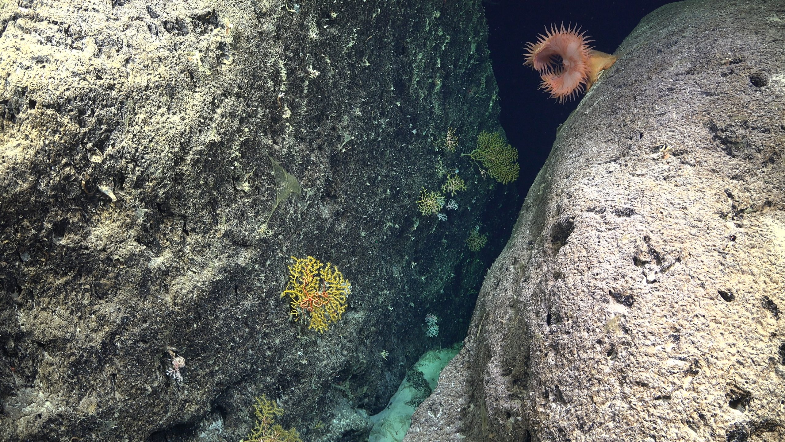
Wednesday, April 16, 2025

Wahine disaster

Wahine disaster survivors on shore near Eastbourne

From NZHistory by Steve Watters

The sinking of the Lyttelton–Wellington ferry Wahine on 10 April 1968 was New Zealand’s worst modern maritime disaster.
Fifty-one people lost their lives that day, another died several weeks later, and a 53rd victim died in 1990 from injuries sustained during the sinking.

The Wahine’s demise also marked a coming of age for television news broadcasting in New Zealand, as images of the disaster were beamed into the nation’s living rooms.
The footage was later screened around the world as the international media focused on Wellington.

Would-be rescuers stood helplessly on the beach at Seatoun as the Wahine succumbed to one of the worst storms recorded in New Zealand history.
It seemed impossible that so many lives could be lost so close to shore.
Although the main cause of the accident was the atrocious weather, a subsequent court of inquiry found that errors of judgement had been made both on board the ferry and on shore.
Shipwrecks had been common in the 19th century, but this was the 1960s – how could a large, modern vessel founder within sight of New Zealand’s capital city?


Hear a contemporary television news broadcast about the loss of the inter-island ferry TEV Wahine in Wellington Harbour on 10 April 1968.
Television coverage of the disaster later won an international World News film award.
 
The Union Steam Ship Company’s 8948-ton roll-on roll-off (RO-RO) passenger ferry Wahine, the largest ship of its kind in the world when completed two years earlier, left Lyttelton at 8.40 p.m.
on the evening of 9 April.
There were 734 passengers and crew on board.
Storm warnings had been issued, but rough seas were nothing new in Cook Strait.
As it turned out, the Wahine was about to sail into one of the worst storms ever recorded in New Zealand.
The ship reached Cook Strait as tropical cyclone Giselle swept south and collided with a southerly front.
The combination of warm tropical air and cold air dragged up from Antarctica produced exceptionally violent turbulence. 

This map charts the course of the Wahine's final voyage in April 1968.
The first screen shows the ship's route from Lyttelton following its departure at 8.40 p.m.
on 9 April to its arrival off the entrance to Wellington Harbour early the following morning.
 
Wahine disaster map
The maps track in more detail the Wahine's final hours as it battled huge seas in the entrance to the harbour.
After a confused half hour in which Captain Robertson apparently attempted to head back out to sea, the vessel struck Barrett Reef and then drifted further north, before finally foundering off Seatoun at about 2.30 p.m.
 
This map of Wellington Harbour is adapted from the original that appeared in the police inquiry report.
It shows the location of the Wahine sinking and some key points in the rescue operation.
 
Localization with the Geogarage platform (Linz nauticalraster chart) 
 
At 5.50 a.m. on the morning of 10 April Captain H. G.Robertson decided to enter Wellington Harbour.
The wind was blowing at over 50 knots, but vessels had entered the harbour in stronger winds before.
Just as the Wahine reached the narrow funnel of the harbour entrance, however, the wind speed suddenly increased to over 100 knots.
Shortly after 6 a.m.
the Wahine’s radar system failed and a huge wave slammed into the ship, throwing many of those on board off their feet.
Now side on to the towering waves, the vessel was pushed towards the notorious Barrett Reef on the western side of the harbour entrance.

For 30 minutes the Wahine fought the waves, as Robertson apparently attempted to turn his ship back out to sea in poor visibility.
At about 6.35 a.m., unaware of his location, the captain ordered full astern.
At 6.40 a.m. the vessel reversed onto Barrett Reef.
The starboard propeller was knocked off, and the port engine stopped shortly after.
Initially many of the passengers were unaware of what was happening due to the ferocious battering the ship was receiving from the storm.

With the ship's engines no longer working, Captain Robertson ordered that all watertight doors be closed and both anchors dropped.
Passengers were now informed that the ferry had run aground on the reef.
The signal station at nearby Beacon Hill was notified of the accident as the crew prepared life-saving equipment.
Flooding in four compartments and on the vehicle deck raised serious concerns about the stability of the ship.


New Zealand Railways' much smaller road/rail ferry Aramoana and other vessels stand by.
credit : Dominion and Sunday Times
Museum of Wellington City and Sea Collection
Reference: 9049
See also film footage of the Wahine disaster on the TVNZ website.
 
The Wahine lists heavily to starboard near Steeple Rock in Wellington Harbour on 10 April 1968.
Lifeboats are just visible on the left.
credit : Alexander Turnbull Library National Library of New Zealand,
Reference: Dominion Post Collection, EP-Accidents-Sea rescue-Wahine-Folder 2 of 4-03
 
The Wahine dragged its anchors and gradually drifted further up the harbour past Point Dorset.
Despite being close to shore, the weather made it impossible for rescuers to reach the ship from land.

The tug Tapuhi set off from Queen’s Wharf and reached the Wahine at about 11.00 a.m.
By 11.50 the tug had secured a line to Wahine.
An attempt was made to tow the ferry to safety, but the line quickly gave way.
Other attempts to get a line to Wahine failed.
Shortly after noon the deputy harbourmaster, Captain Galloway, managed to climb aboard the Wahine from the pilot launch, which had also reached the scene.
He risked his life jumping from a heavily pitching launch to a ladder hanging over the starboard side of the ship. 

Abandon ship

By 1.15 p.m. the Wahine was listing heavily to starboard.
The tide and storm had swung the ship around so that there was a patch of water sheltered from the wind and waves on the lower starboard side.
Just before 1.30 p.m. the order was finally given to abandon ship.

19-year-old Kate McGibbon (now Watson) and her rescuer Eroni Vakacegu on the shore near Eastbourne, 10 April 1968.

Captain Robertson had resisted this call because he felt that the storm conditions meant it was safer for the passengers to remain on board.
He was also keen to avoid causing any unnecessary panic.
Passengers, who had been unaware of just how serious the situation was, were now confused and frightened.
People slid across the sloping deck, trying to make their way to the lifeboats.
Some passengers had removed their life jackets during the morning and were using them as pillows when the order came to abandon ship.
Others were initially directed by crew to move to the high (port) side of the ship, from which it was impossible to launch the lifeboats, before making their way to the low side.

Only the four starboard lifeboats could be launched, and crewmen tried to get as many people as possible onto them.
One lifeboat was swamped shortly after leaving the sinking ship and its occupants were tossed into the sea.
(Two of the other lifeboats safely reached Seatoun; the third landed at Eastbourne).
Other passengers were forced to jump into the cold, churning sea.
Some clung on to inflatable liferafts that had been thrown overboard, but a number of these were punctured by the wreckage or flipped over by the heavy seas.

At about 2.30 p.m.the now-abandoned Wahine capsized in 11.6 metres of water just east of Steeple Rock Light and crashed heavily to the seabed.
By this time the first of the survivors had already reached the western shore at Seatoun.

Members of a Japanese salvage firm and Royal New Zealand Navy divers inspect the wreckage of the Wahine about eight days after it sank on 10 April 1968.
These and later examinations revealed that the damage to the ship's hull was much worse than was first thought.
The plating and frames had been so badly damaged by the hard impact as the vessel struck the sea floor that any salvage effort was impossible.
The Wahine therefore became a total loss.
credit :Alexander Turnbull Library
Reference: Dominion Post Collection, EP-Accidents-Sea rescue-Wahine-Folder 4 of 4-01

The Wahine was within sight of land and many other vessels, including the smaller New Zealand Railways Wellington-Picton ferry Aramoana, which stood by to pick up survivors.
Many were blown across the harbour towards Eastbourne Beach, an area with difficult access.
Rescue teams found the road to Eastbourne blocked by slips.
Eventually 200 survivors struggled through the surf to safety on this coast, but it was here that most of the 51 fatalities occurred.
A number of people who reached shore alive did not receive medical attention quickly enough to prevent death from exposure.
Others were drowned or killed when thrown against rocks.

Robertson and Galloway were the last to abandon ship after checking that no one remained on the ferry.
They spent an hour in the water near the wreck before being rescued.

Although the stricken Wahine was close to New Zealand's capital city, the rescue effort was delayed by several hours due to uncertainty over the ship's fate.
Those on shore were only just beginning to realise the gravity of the situation.
Emergency services were fully stretched dealing with numerous call-outs as the storm tore roofs off houses, toppled trees and caused injuries as people were hit by flying debris.

Because of slips blocking the road, only eight police officers were initially able to get to Eastbourne.
Eventually another 100 officers and 150 civilians were involved in the rescue effort there.
This was a difficult task in appalling weather, and many worked through the night to assist survivors.
In all, 371 police members out of a total of 629 in the Wellington district, national headquarters and the training school were involved.


A lifeboat from the Wahine comes ashore alongside Seatoun Wharf, 10 April 1968.


This photograph shows volunteers recovering a liferaft from the Wahine which had been blown onto the eastern shore.
Some people who had survived everything else died when dashed against the rocks.
credit : Ian McFarlane Museum of Wellington City and Sea Collection Ref: 2166
Wahine survivors being rescued

Chief Inspector George Twentyman of Police National Headquarters took charge of co-ordinating the rescue at 2.05 p.m.
He had been involved in the 1953 Tangiwai disaster operation where he had observed first-hand the confusion and stress created by handling inquiries in the same place as the rescue effort.
He therefore immediately set up separate groups in different locations to handle the various aspects of the operation and allow the rescue effort to go forward unimpeded.
Separate points in the city were established to deal with inquiries about the passengers and crew while a survivor assembly station was set up at Wellington railway station.
A mortuary and property section was also established.

Events at Tangiwai had also been hampered by the fact that no national civil defence organisation existed.
By 1968 this was no longer the case, and a quick mobilisation of local authority, military and civilian volunteer assistance was now possible.
The Wellington harbour master controlled the sea rescue.

Police Diving Squad

This was one of the first high-profile police diving missions, and the divers provided vital evidence at the court of inquiry.
Until the Wahine’s sinking, this squad had existed as a group of voluntary enthusiasts from around the Wellington and Hutt districts.
Some of these members performed a dangerous dive on the Wahine wreck to recover the radio log from the bridge.

Chief Inspector George Twentyman, who was in charge of the police response to the Wahine tragedy, realised that a court of inquiry was bound to follow.
He ensured that a comprehensive and accurate paper trail existed.
Every decision and communication was documented, and these records, together with the personal reports of the officers commanding sections, formed the basis for a very full debriefing report on the police organisation during the disaster.
This was a first as far as police procedure was concerned and is now standard practice. 

The court of inquiry that met 10 weeks after the sinking pinpointed the build-up of water in the vehicle deck as the reason the ferry finally capsized.
The ship’s enormous two-tiered vehicle deck could hold over 200 cars and spanned nearly the entire length and breadth of the ship.
When water entered the vehicle deck, it sloshed from one side of the ship to the other.
This momentum increased the vessel’s list to starboard until it reached a critical point, forcing the captain to order those on board to abandon ship.
The rush to the lower, starboard lifeboats produced a slight but sudden shift in weight that was sufficient to cause the ship to lose any remaining stability.

One question focused on the timing of the decision to abandon ship, but the report of the inquiry concluded that more lives would almost certainly have been lost if this order had been given earlier.
The storm was so strong that rescue craft would not have been able to assist any earlier than 12.30 p.m.

Captain Robertson was criticised for failing to report to those on shore that the vehicle deck was taking on water and that the ship's draught had increased to 6.7 metres after striking the reef.
The extreme nature of the storm, though, was ultimately responsible for the tragic events of that day.


Tuesday, April 15, 2025

Revealing underwater landscapes: trends in bathymetric surveying

Through the power of technology, ocean exploration can go deeper than ever before.
Innovative platforms from companies like Arm mean artificial intelligence can be used to map the ocean floor for the first time in history.

From GPSWorld by Jesse Khalil

Nearly three quarters of Earth’s surface is covered by water, yet only about a quarter of that surface has been mapped in detail using modern high-resolution technology.

Marine experts worldwide work together to chart the ocean floor, ensuring the safety of ports, harbors and navigable routes.
This effort is crucial for global trade, as more than 90% of goods are transported by ships.
Ocean floor surveying also supports the installation of offshore infrastructure such as fiber optic cables, pipelines, drilling platforms and wind turbines.

The increasing population in coastal regions and rising sea levels due to climate change have heightened the importance of observing coastal transformations, erosion and other marine alterations.
These factors are essential for understanding and protecting coastal ecosystems.

Mapping techniques

In deep waters, massive multi-beam echo sounders (MBES) operating at very low frequencies collect depth data.
As water depth decreases, smaller devices with higher frequencies and resolution must be used.
However, near the shore, these devices become less efficient due to the slope of the shelf interfering with sound signals.

In near-shore scenarios, collecting depth data is best done using airborne lidar sensors, which offer several advantages over sensors on surface vessels.
One advantage of airborne sensors is that they can simultaneously map both the seafloor and the adjacent topography to offer seamless land-water transition data.
This capability is particularly valuable in dynamic coastal environments where rapid coverage of large areas is essential.

Bathymetric lidar is specifically designed for mapping shallow coastal waters, typically effective up to depths of 50 m.
It can provide high-resolution data, often achieving sub-meter positional accuracy, which is crucial for detailed coastal mapping.
By combining MBES for deeper waters with lidar for near-shore areas, researchers and surveyors can create comprehensive and accurate maps of the entire coastal zone.
This method offers an in-depth understanding of underwater topography, aiding various applications in marine science, coastal management and navigation.


The waters of the Cayman Islands are abundant in marine life, featuring coral reefs, seagrass beds and a variety of fish species.
A high-resolution map of the seafloor is essential to begin exploring, identifying, characterizing, exploiting, conserving and managing ocean resources.
Saildrone has begun a mission to map 29,300 square nautical miles (100,490 sq km) of the Cayman Islands’ Exclusive Economic Zone (EEZ).
This mission uses autonomous technology to survey 80% of this EEZ.

The Cayman Islands EEZ, extending up to 200 nautical miles from shore, encompasses an area nearly half the size of Florida — and 380 times greater than the island itself.
The mission will provide detailed and precise bathymetric data for this area, contributing to a comprehensive understanding of the seafloor topography in the region.
The data collected seeks to enhance maritime navigation and support scientific research, environmental conservation efforts and marine resource management in the Cayman Islands.

“Our waters hold such great value to us for a myriad of reasons, ranging from recreational to economic.
Conducting this assessment will allow our government to make data-driven decisions that will strengthen our policies and legislation as it relates to our maritime infrastructure,” said Juliana O’Connor-Connolly, premier and minister for District Administration and Lands.
 
The Saildrone Surveyor USV is a purpose-built platform for autonomous deep-water ocean mapping.
(Photo: Saildrone)


The mission is philanthropically funded by the London and Amsterdam Trust Company Limited, a Cayman-based organization.
Saildrone is tasked with collecting the raw bathymetry data, which will be provided to the UK Hydrographic Office to process and update the Cayman Islands’ nautical charts.
The data will belong to the government of the Cayman Islands.

Autonomous seafloor exploration


The mission is being conducted using a 20-m Saildrone Surveyor uncrewed surface vehicle (USV) equipped with MBES and metocean sensors for ocean mapping and ecosystem monitoring, as well as radar, cameras and advanced machine learning.
Metocean stands for meteorology and physical oceanography.
Globally, only 26% of the ocean has been mapped, a result of the lack of survey ship capacity.
While a survey ship takes years to build, Saildrone can produce one Surveyor in as little as six weeks.
 
This nautical chart shows the Cayman priority mapping areas.
UL: 19.464 N, 83.59667 W
LR: 19.0582 N, 82.02195 W

The yellow oval indicates the vessel’s location as of Dec. 9, 2024.
(Photo: Saildrone)


Saildrone USVs have demonstrated a reduction of more than 97% in operational carbon emissions when compared to survey ships to accomplish the same task.
Additionally, they lower the risk to personnel.
This information is highlighted in Saildrone’s Carbon Impact Report, which provides a comprehensive evaluation of the carbon emissions associated with maritime data collection and the emissions mitigated by using Saildrone’s USVs.

Saildrone’s ocean mapping solutions support storm surge modeling efforts and emergency response, as well as coastal resiliency and hazard studies, resource management, restoration projects, habitat mapping and infrastructure for renewable energy generation.
USVs equipped with deep ocean mapping sonars now serve as a reliable option for data collection in large areas such as EEZs.

Trimble Emerging trends in Bathymetry

Bathymetry is crucial to understanding Earth’s aquatic environments.
Its importance has evolved significantly since the early days of navigation, when mariners relied on lead lines and poles to gauge water depths.
The field of bathymetry continues to advance with emerging trends that enhance data collection capabilities.
Autonomous platforms such as USVs and autonomous underwater vehicles are increasingly utilized for bathymetric surveys, allowing for more extensive and detailed mapping.
Additionally, as the industry grapples with challenges such as workforce shortages and the need for more efficient data collection methods, autonomous systems are proving to be a valuable solution.

Trimble’s Applanix POSPac MMS, an advanced GNSS-inertial post-processing software, seamlessly integrates with the Applanix POS MV and multibeam or sonar sensors to deliver high-accuracy results.
(Photo: Trimble)


“Autonomous and uncrewed platforms have become a real force multiplier, and the trend continues,” said Peter Stewart, director of marine products at Trimble Applanix.
“Companies such as XOcean and Saildrone are showing what is possible, leveraging cloud processing and enabling data collection in remote areas while maintaining a work-life balance for their staff.
Since finding qualified engineers and surveyors to fill these roles offshore is an industry-wide concern, more flexible working conditions are needed to hire and retain talent.”

Another emerging trend is the development of sensors capable of penetrating murky waters, which can significantly enhance surveyors’ ability to gather data in challenging environments.
Advanced sonar systems, innovative light-and-sound combinations and newly developed sensors allow research teams to collect detailed data.
Post-processing technology for bathymetry has also significantly advanced, making data acquisition, processing and presentation more efficient and accessible.
This allows researchers to map and study underwater terrains that were previously inaccessible or poorly understood.

Typical marine vessel data processed in POSPac MMS PP-RTX mode.
(Photo: Trimble)


“Ease of use and installation are key trends toward ensuring valuable hydrographic data can be acquired, processed and presented efficiently,” Stewart said.
Trimble works with users and third parties to offer an optimal workflow, making technology and the data it creates more accessible and operations more efficient, he added.

The IN-Fusion+ PP-RTX2 processing mode in Trimble’s POSPac MMS software is designed to improve post-processed GNSS-inertial trajectory generation.
This mode uses Trimble’s CenterPoint RTX technology to deliver centimeter-level positioning accuracy without the need for local base stations.
Stewart shared how this technology can be particularly useful when surveying around offshore windfarms, where shore-based RTK infrastructure is often too distant to be useable.
 
Links :

Monday, April 14, 2025

Talks over the Chagos Islands show the rising clout of Mauritius

Small island, big fuss
photograph: zelwanka/dreamstime
 
From The Economist by

And the influence of India, which is building facilities on another Mauritian island

In a tatty office in Port Louis, the capital of Mauritius, Olivier Bancoult points to the tricolour flag on the wall.
It is that of the Chagos Islands, the largest of which, Diego Garcia, hosts a British-American base.
Its construction in the early 1970s was preceded by the forcible expulsion of 1,500 Chagossians, including Mr Bancoult, then four years old.
Britain detached the Chagos dependency from the colony of Mauritius, 2,000km away, before Mauritius was granted independence in 1968.
The orange represents sunsets, says Mr Bancoult.
The black is for the dark times faced by Chagossian refugees, some of whom his ngo represents.
And the blue? “That is for the seas—and our future.”

Localization in the Indian Ocean (UKHO nautical raster chart) with the GeoGarage platform
 
A new future for the Chagos is approaching.
On April 1st a British government spokesman said that Britain was finalising a deal to hand sovereignty to Mauritius, as it was advised to do in 2019 by the International Court of Justice.
The comments suggest that Donald Trump will not try to block an agreement, though some members of his new team criticised the deal back in October, when it was blessed by the outgoing Biden administration.

Assuming a deal is finalised—and Britain and Mauritius go on to sign a treaty—it would underline the growing geopolitical importance of the island state, often known more for its beaches than its bases.
Though small in land mass, Mauritius claims a maritime zone spanning 2.3m square km, roughly the same as the area of Africa’s largest country, Algeria.

This part of the Indian Ocean has important shipping lanes and potential mineral resources.
It is an arena of competition for the West, China and rising powers, especially India, which is building air and naval facilities on Agaléga, a less well-known pair of Mauritian islands.
Narendra Modi, India’s prime minister, visited Port Louis in March.
Emmanuel Macron, France’s president, is expected this month; he may try to head off legal challenges over Tromelin Island, a French territory also claimed by Mauritius.
“The powers are competing and we have to take advantage,” says Dhananjay Ramful, Mauritius’s foreign minister.

Diego Garcia is the location of a UK-US military airstrip
photo : Reuters
 
To understand the role of Mauritius, start with the Chagos Islands.
In a sign of their continuing importance to America, Washington has recently sent several b-2 stealth bombers to Diego Garcia amid rising tensions with Iran; these can carry bunker-buster bombs which, analysts have suggested, would be used in any strike on Iranian nuclear facilities.

Since America was never going to agree to Britain ceding total control over the base, the deal announced last year had a fudge large enough to please Willie Wonka.
Mauritius gets sovereignty over the archipelago.
But Britain retains “sovereign rights” over Diego Garcia.

 Diego Garcia isalnd (UKHO nautical raster chart) with the GeoGarage platform
 
Critics of the deal (including The Economist) have argued that what one former American official praises as “delegated sovereignty” still leaves the West vulnerable.
They say that a future government in Port Louis could renege or give China a base on another of the Chagos’s 60-odd islands.
“One base is enough,” insists Mr Ramful.
‘We’re not Djibouti,” adds an official, referring to the small African state that hosts bases for, among others, America, China, France and Japan.

Navinchandra Ramgoolam, the prime minister, hopes such assurances are sufficient.
He has tried to negotiate frontloading payments Britain will make for its rights over Diego Garcia.
Mauritius, an off-shore financial centre, needs to close its fiscal deficit to head off a downgrading of its credit rating.

The focus on the Chagos has taken attention away from Agaléga.
Indian diplomats reject any comparison between the two.
But since India and Mauritius signed a deal in 2015, the construction of a jetty and a long runway has raised questions about whether India is building a base.
Mr Ramgoolam has backtracked from a pledge to make that agreement public.

“It’s nothing like a military base,” says Eshan Juman, an mp representing Agaléga.
“It’s a loading station,” adds the Mauritian official.
Some reckon this is semantic sophistry.
“It fools nobody,” says a former minister.
“You don’t need such a runway for an island of a few hundred people.”

Though some in the Mauritian elite worry about becoming a vassal state without vessels, many believe outsourcing security to India makes practical sense.
Mauritius’s national security adviser has for decades been an Indian.
Its coastguard is equipped by India.
Giving India a foothold in Agaléga, argues another official, makes all the more sense, given that it is becoming more powerful globally.

Indeed, if Mauritius is the main beneficiary of the Chagos deal, then India, given its influence over the island’s foreign policy, is the other.
Mauritius’s founding prime minister is said to have described the island’s foreign policy as being the mistress of many and the wife of none.
These days it seems it has got hitched to India.

Links :

Sunday, April 13, 2025

Oldest depiction of diving 3000 years ago

The oldest known depiction of an Assyrian soldier, dating back 3,000 years, shows the man diving while using an inflatable goatskin bag to float and breathe.
Think again if you believe scuba diving is a modern invention.
The scene is captured on a 9th-century BC tablet, now preserved in the British Museum, and highlights the ingenious survival techniques employed by one of history's most powerful civilizations.
The inflatable goatskin acted as an ancient life jacket or snorkeling aid, allowing soldiers to cross rivers undetected during military campaigns.
The Assyrian civilization thrived as a result of its technological and strategic innovations.
It's incredible to think that thousands of years ago, such creative solutions were already being used.
Image: Ingvar Svanberg, Isak Lidström, Folk Life Journal / Jolene Creighton 
source : Twitter