Saturday, October 5, 2024
Friday, October 4, 2024
We now know who was cannibalised on the doomed Franklin expedition

The Franklin expedition was dramatised in television show The Terror
From New Scientist y Jeremy Hsu
DNA and genealogical evidence reveal, for the first time, the
identity of cannibalised remains recovered from the Franklin expedition
Human remains recovered from the British Royal Navy’s doomed Franklin expedition have been identified as Captain James Fitzjames using DNA and genealogical evidence.
Human remains recovered from the British Royal Navy’s doomed Franklin expedition have been identified as Captain James Fitzjames using DNA and genealogical evidence.
The unfortunate officer has also been confirmed as the first known victim of cannibalism among the expedition members.
In 1845, an expedition led by Sir John Franklin set out to find a navigable North-West Passage through the Arctic with 129 men aboard the ships HMS Terror and HMS Erebus.
In 1845, an expedition led by Sir John Franklin set out to find a navigable North-West Passage through the Arctic with 129 men aboard the ships HMS Terror and HMS Erebus.

An illustration of the HMS Erebus, which got stuck in the ice during an expedition to cross the Northwest Passage in the 19th century.
Credit: Universal History Archive
But in 1848, Captain James Fitzjames, commander of the HMS Erebus, left a report in a stone cairn recording how the survivors had decided to abandon the ships.

Daguerreotype of Captain James Fitzjames, 1845.
(FabTet/CC BY-SA 4.0)
Later, the unidentified skeletal remains of many sailors were discovered in various locations across the Canadian Arctic.

The Erebus and Terror during Ross's Antarctic expedition.
Credits: NOAA Central Library
Now researchers have put a name to some of those remains.
“Identifying an individual using molecular methods often takes time because descendants need to be involved in the process,” says Treena Swanston at MacEwan University in Canada, who was not involved in the study.
Douglas Stenton at the University of Waterloo in Canada and his colleagues identified Fitzjames by comparing the Y chromosome profiles from a tooth that was found on Canada’s King William Island with cheek swabs taken from one of Fitzjames’s descendants.
Douglas Stenton at the University of Waterloo in Canada and his colleagues identified Fitzjames by comparing the Y chromosome profiles from a tooth that was found on Canada’s King William Island with cheek swabs taken from one of Fitzjames’s descendants.
The descendant donor had a demonstrated genealogical relationship with Fitzjames through the captain’s great-grandfather.

Cut marks on this mandible, now identified as that of James Fitzjames, indicate it was cannibalised
Anne Keenleyside
The discovery also makes Fitzjames the first identified victim of cannibalism among the Franklin expedition’s members.
Earlier analysis by the late bioarchaeologist Anne Keenleyside had revealed cut marks on many of the recovered remains, with one lower jawbone – now identified as belonging to Fitzjames – having multiple cut marks.

This indicates some of the last survivors who were trekking overland resorted to eating parts of Fitzjames’s body and those of several other sailors.
The finding “reveals the desperation of the Franklin sailors”, says Swanston.
Such research also reinforces the importance of testimony from Indigenous Inuit people, she says.
Such research also reinforces the importance of testimony from Indigenous Inuit people, she says.
The Inuit reported seeing about 40 men dragging a ship’s boat on a sledge and made the first discoveries of bodies showing signs of cannibalism.
Links :
Links :
- New Scientist : Our human ancestors often ate each other, and for surprising reasons / Fossil evidence shows that humans have been practising cannibalism for a million years. Now, archaeologists are discovering that some of the time they did it to honour their dead
- LiveScience : In a 1st, DNA analysis reveals identity of captain cannibalized during ill-fated Franklin expedition / Cracked Bones Reveal Cannibalism by Doomed Arctic Explorers
- Zrs Technica : Franklin expedition captain who died in 1848 was cannibalized by survivors
- Ancient Origins : Cannibalized Sailor From Doomed Arctic Expedition Identified Through a DNA
- The Guardian : Scurvy, hypothermia and cannibalism: DNA sheds light on victim of Northwest Passage expedition
- The Independant : Cannibalised remains from doomed 1845 British Arctic expedition finally identified
- DailyMail : Meet the man who was CANNIBALISED on board the doomed 1845 Franklin Expedition: DNA samples confirm skeletal remains belong to British first officer James Fitzjames / Last known photos of officers from doomed 1845 expedition which saw men turn to cannibalism when ships got stuck in Arctic ice are set to fetch up to £200,000 at auction
- Smithsonian : Franklin’s Doomed Arctic Expedition Ended in Gruesome Cannibalism
- Mpora : The Terror | What Happened To The Real Life Franklin Expedition?
- CNN : The last photos of John Franklin’s doomed polar expedition party are going on sale
- GeoGarage blog : Arctic shipwreck 'frozen in time' astounds archaeologists / Ship found in Arctic 168 years after doomed Northwest ... / In 1845 explorers sought the Northwest Passage—then ... / Canada searches for Sir John Franklin's rescue ship / Canada finds British vessel that vanished on doomed ... / A brief history of voyages through the Northwest Passage
Thursday, October 3, 2024
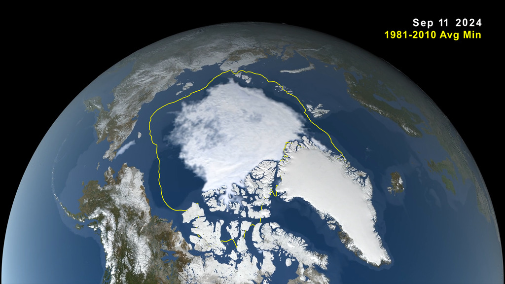
Arctic sea ice near historic low; Antarctic ice continues decline
This summer, Arctic sea ice decreased to a its minimum extent on
September 11, 2024.
According to the National Snow and Ice Data Center this is the 7th lowest in the satellite record).
According to the National Snow and Ice Data Center this is the 7th lowest in the satellite record).
The decline continues
the long-term trend of shrinking ice cover in the Arctic Ocean.
Credit: NASA’s Goddard Space Flight Center
Credit: NASA’s Goddard Space Flight Center
From NASA
Arctic sea ice retreated to near-historic lows in the Northern Hemisphere this summer, likely melting to its minimum extent for the year on Sept.11, 2024, according to researchers at NASA and the National Snow and Ice Data Center (NSIDC).
The decline continues the decades-long trend of shrinking and thinning ice cover in the Arctic Ocean.
The amount of frozen seawater in the Arctic fluctuates during the year as the ice thaws and regrows between seasons.
Scientists chart these swings to construct a picture of how the Arctic responds over time to rising air and sea temperatures and longer melting seasons.
Over the past 46 years, satellites have observed persistent trends of more melting in the summer and less ice formation in winter.
This
image, taken from a data visualization, shows Arctic sea ice minimum
extent on September 11, 2024.
The yellow boundary shows the minimum extent averaged over the 30-year period from 1981 to 2010.
Download high-resolution video and images from NASA’s Scientific Visualization Studio: svs.gsfc.nasa.gov/5382
NASA’s Scientific Visualization Studio/Trent L. Schindler
The yellow boundary shows the minimum extent averaged over the 30-year period from 1981 to 2010.
Download high-resolution video and images from NASA’s Scientific Visualization Studio: svs.gsfc.nasa.gov/5382
NASA’s Scientific Visualization Studio/Trent L. Schindler
Tracking sea ice changes in real time has revealed wide-ranging impacts, from losses and changes in polar wildlife habitat to impacts on local communities in the Arctic and international trade routes.
This year, Arctic sea ice shrank to a minimal extent of 1.65 million square miles (4.28 million square kilometers).
That’s about 750,000 square miles (1.94 million square kilometers) below the 1981 to 2010 end-of-summer average of 2.4 million square miles (6.22 million square kilometers).
The difference in ice cover spans an area larger than the state of Alaska.
Sea ice extent is defined as the total area of the ocean with at least 15% ice concentration.
Seventh-Lowest in Satellite Record
This year’s minimum remained above the all-time low of 1.31 million square miles (3.39 million square kilometers) set in September 2012.
While sea ice coverage can fluctuate from year to year, it has trended downward since the start of the satellite record for ice in the late 1970s.
Since then, the loss of sea ice has been about 30,000 square miles (77,800 square kilometers) per year, according to NSIDC.
Scientists currently measure sea ice extent using data from passive microwave sensors aboard satellites in the Defense Meteorological Satellite Program, with additional historical data from the Nimbus-7 satellite, jointly operated by NASA and the National Oceanic and Atmospheric Administration (NOAA).
Sea ice is not only shrinking, it’s getting younger, noted Nathan Kurtz, lab chief of NASA’s Cryospheric Sciences Laboratory at the agency’s Goddard Space Flight Center in Greenbelt, Maryland.
“Today, the overwhelming majority of ice in the Arctic Ocean is thinner, first-year ice, which is less able to survive the warmer months.
There is far, far less ice that is three years or older now,” Kurtz said.
Ice thickness measurements collected with spaceborne altimeters, including NASA’s ICESat and ICESat-2 satellites, have found that much of the oldest, thickest ice has already been lost. New research out of NASA’s Jet Propulsion Laboratory in Southern California shows that in the central Arctic, away from the coasts, fall sea ice now hovers around 4.2 feet (1.3 meters) thick, down from a peak of 8.8 feet (2.7 meters) in 1980.
Another Meager Winter Around Antarctica
Sea ice in the southern polar regions of the planet was also low in 2024.
Around Antarctica, scientists are tracking near record-low sea ice at a time when it should have been growing extensively during the Southern Hemisphere’s darkest and coldest months.
Ice around the continent is on track to be just over 6.6 million square miles (16.96 million square kilometers).
The average maximum extent between 1981 and 2010 was 7.22 million square miles (18.71 million square kilometers).
The meager growth so far in 2024 prolongs a recent downward trend.
Prior to 2014, sea ice in the Antarctic was increasing slightly by about 1% per decade.
Following a spike in 2014, ice growth has fallen dramatically.
Scientists are working to understand the cause of this reversal.
The recurring loss hints at a long-term shift in conditions in the Southern Ocean, likely resulting from global climate change.
“While changes in sea ice have been dramatic in the Arctic over several decades, Antarctic sea ice was relatively stable. But that has changed,” said Walt Meier, a sea ice scientist at NSIDC.
“It appears that global warming has come to the Southern Ocean.”
In both the Arctic and Antarctic, ice loss compounds ice loss.
This is due to the fact that while bright sea ice reflects most of the Sun’s energy back to space, open ocean water absorbs 90% of it.
With more of the ocean exposed to sunlight, water temperatures rise, further delaying sea ice growth.
This cycle of reinforced warming is called ice-albedo feedback.
Overall, the loss of sea ice increases heat in the Arctic, where temperatures have risen about four times the global average, Kurtz said.
Links :
- Arctic Today : New report: Arctic could be vital supplier of critical minerals for global green transition
- Scientific American : Parts of Antarctica are turning green at an 'astounding' rate
- GeoGarage blog :Arctic sea ice thinning twice as fast as thought, study finds / Pumped up: will a Dutch startup's plan to restore Arctic sea- ... / Arctic could be ice-free as early as 2030s says study / 'The heat bombs' destroying Arctic Sea Ice / The old Arctic is gone / The Arctic is a freezer that's losing power / As Arctic ice vanishes, new shipping routes open / Shipping's Arctic future / Arctic shipping routes are expanding faster than predicted / Container ship crosses Arctic route for first time in history ... / Welcome to the Arctic: degraded radios, poor satellite ... / Weakened 'ice arches' speed loss of Arctic floes / Arctic melt time lapse / Under the spell of the ice and cold on an Arctic expedition / The Arctic fails its annual health check as global warming ... / An abandoned Arctic military base just spilled a scientific ... / The Arctic Ocean began warming decades earlier than ... / A caustic shift is coming for the Arctic ocean / Solving the mystery of the Arctic's green ice / The Arctic Ocean, explained / Time-lapse video shows how quickly older Arctic Sea ice is ... / New warning on Arctic sea ice melt / Disappearing ice / making maps for the first Arctic Permafrost Atlas / Arctic ice cover hits historic low / Siberia heatwave: why the Arctic is warming so much faster ... / Satellites show sea ice in Arctic is at a record low / Arctic shipper shows off a historical icebreaking voyage / First ship crosses Arctic in winter without an icebreaker as ...
Wednesday, October 2, 2024
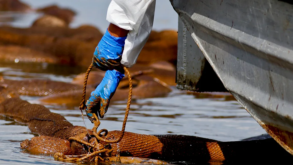
The biggest oil spill in US history: What we've learned since Deepwater Horizon
Over a decade on from the Deepwater Horizon oil spill, could we do a better job at cleaning it up today?
Credit: Getty Images
From BBC by Jocelyn Timperley
Fourteen years after the BP Deepwater Horizon disaster, would we fare any better at cleaning up another huge oil spill?
Jocelyn Timperley examines the latest science of ocean clean-ups.
On April 20, 2010, a blowout caused a huge explosion on the offshore drilling rig operated by BP in the Gulf of Mexico.
Eleven people were killed.
Two days later, the rig collapsed.
Oil began seeping into the sea, and it continued to flow for almost three months.
The Deepwater Horizon disaster is among the most lamented environmental catastrophes of the past century.
It's hard to comprehend how incredibly huge the spill was.
It was the world's largest ever marine oil spill, releasing an estimated 4.9 million barrels of crude oil (779 million litres, or over 300 Olympic swimming pools-worth).
Up to a million seabirds were killed outright, and the human health and socioeconomic effects are still being felt today.
BP, rig operator Transocean, and several government agencies immediately tried to limit the damage, with BP's chief executive saying the company was "determined to do everything in our power" to contain the spill.
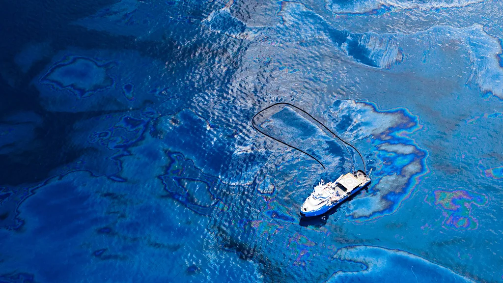
Booms were deployed to try to contain the oil, skimmer ships nibbled at the edges of the widening slick and fires were set to try to burn it off the sea surface.
Various devices were deployed deep below the surface to try to contain or capture the oil.
BP also began to spray the oil with enormous amounts of dispersants both on the sea surface and 1.5km (0.9 miles) underwater, where oil was gushing from the wellhead.
However, it is thought that these measures recovered or dispersed only around a third of the spilled oil.
The BP spill sparked a huge amount of research into oil spills and their impacts.
But 14 years on, what hope is there for better measures should another oil spill occur?
On April 20, 2010, a blowout caused a huge explosion on the offshore drilling rig operated by BP in the Gulf of Mexico.
Eleven people were killed.
Two days later, the rig collapsed.
Oil began seeping into the sea, and it continued to flow for almost three months.
The Deepwater Horizon disaster is among the most lamented environmental catastrophes of the past century.
It's hard to comprehend how incredibly huge the spill was.
It was the world's largest ever marine oil spill, releasing an estimated 4.9 million barrels of crude oil (779 million litres, or over 300 Olympic swimming pools-worth).
Up to a million seabirds were killed outright, and the human health and socioeconomic effects are still being felt today.
BP, rig operator Transocean, and several government agencies immediately tried to limit the damage, with BP's chief executive saying the company was "determined to do everything in our power" to contain the spill.
Booms were deployed to try to contain the oil, skimmer ships nibbled at the edges of the widening slick and fires were set to try to burn it off the sea surface.
Various devices were deployed deep below the surface to try to contain or capture the oil.
BP also began to spray the oil with enormous amounts of dispersants both on the sea surface and 1.5km (0.9 miles) underwater, where oil was gushing from the wellhead.
However, it is thought that these measures recovered or dispersed only around a third of the spilled oil.
The BP spill sparked a huge amount of research into oil spills and their impacts.
But 14 years on, what hope is there for better measures should another oil spill occur?
Jeffrey Short, an expert in oil spills and now-retired scientist from the US National Oceanic and Atmospheric Administration (Noaa), was working for Oceana, a marine conservation organisation when the BP spill occurred.
When a colleague told him about the spill at lunchtime, he felt sick.
"I knew immediately that this would be ecologically and economically disastrous, that it would wreck tens of thousands of people's lives, and that it would dominate my professional life for the next several years," he says.
"All of which proved true."
Oil spills are the third largest source of oil in the sea, after land-based runoff (largely from cities and vehicles) and natural oil seeps.
The problem with spills, of course, is the sheer volume of oil that enters the sea all at once.
This means that oil spills – especially big ones – are "much, much more dangerous per unit oil released", says Short.
While no spill has since surpassed Deepwater Horizon's in sheer volume, Noaa responds to more than 150 oil spills every year.
Just last month, oil began spewing from a submerged oil tanker and at least two other sunken vessels in Manila Bay, in the Philippines, after they were hit by monsoon rains and Typhoon Gaemi.
Another oil tanker hit by projectiles from Yemen's Houthi movement remains in a precarious position in the Red Sea.
However, the number of oil spills from tankers is today far lower than in the 1970s, due to improved standards.
When oil spills occur, the first step is to control the source, "whether that be a ship, pipeline, or leaking well", says Doug Helton, regional supervisor of the emergency response division at Noaa's Office of Response and Restoration.
"The second priority is recovering oil at sea."
The major priority is to avoid the oil reaching the shoreline, where it can do the most damage.
Shoreline cleanups can last days to years, depending on the type of oil and severity of contamination, says Helton.
Spilt oil tends to spread quickly into a thin layer on the sea surface.
Within days, centimetres-thick layers become a film of a millimetre or less, spread in drifting patches over a wide area.
Efforts to scoop up the oil from the sea surface therefore offer diminishing returns as time goes on.
"Floating oil spreads very quickly and there is a limited window of time – days – when at-sea tools are effective," says Helton.
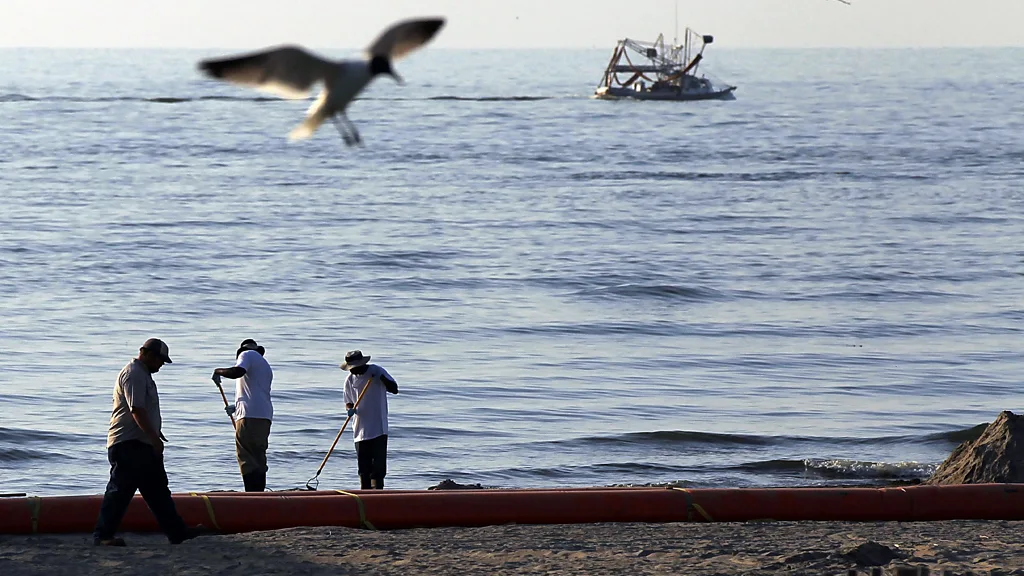
Workers attempt to clean up an oil-contaminated beach in Grand Isle, Louisiana, June, 2010 (Credit: Getty Images)
Hundreds of skimmers were deployed to clean up the BP Deep Horizon spill.
Skimmers are boats that scoop up spilled oil from the water's surface, usually after the slick is first surrounded with floating booms to keep it from spreading.
They do this in various ways – some, for example, suck up the oil like a vacuum cleaner, while others use oil-attracting "conveyor belts" or gravity to carry the spilled oil into a reservoir.
But hopes at the time that the skimmers could pick up oil "like a lawnmower cutting grass" proved to be overblown.
They only recovered an estimated 3% of the oil.
"At sea, the oil may spread more rapidly than the skimming vessels trying to capture oil," says Helton.
"Going faster is not an easy option because the bow wave from the ship will push the oil away."
The satellite photos of the BP disaster "speak volumes", says Short.
"You'll see a half a dozen surface skimming boats that, from the sea surface next to the boat, look quite large and quite effective.
But from a satellite, you realise that you are [...] just having a nearly negligible effect on the size of the spill."
In fact, a 2020 review of 30 large offshore oil spills found only 2-6% of oil was recovered using mechanical methods like skimmers.
Short says that mechanical recovery has improved in recent decades, with better booms to corral the oil and better systems to remove it from the sea surface.
But even with improvements, mechanical methods can't have much impact on a large spill, he says.
In recent years a plethora of studies and reports have emerged looking at different ways to soak up oil spills, from laser-treated cork and textiles based on leaves to graphene, magnets and even hair and fur.
These mostly rely on the oil-attracting and water-hating properties of the material, with various forms of oil-attracting sponges a particularly common solution.
But the difficulty of handling oil-soaked materials means these techniques are typically only useful for small spills.
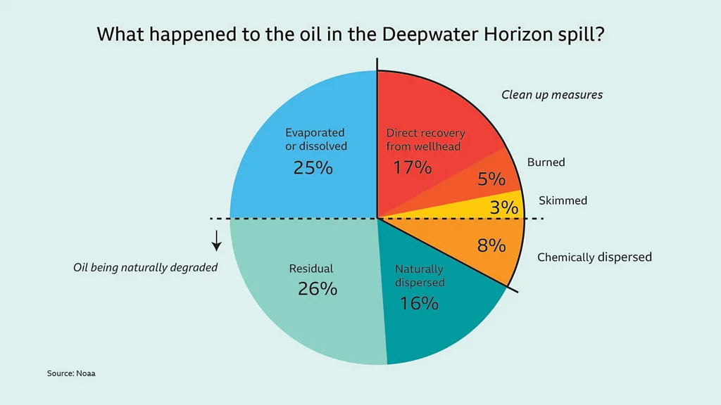
Best estimates of what happened to the oil from the BP Deepwater Horizon disaster
(Credit: Noaa/BBC)
When Guihua Yu, a professor of materials science at the University of Texas at Austin, and his team began considering whether a new material his lab was working on could be used to help clean up oil spills, he says he was surprised about the lack of focus on how these innovative materials could be used in practice.
One central problem, he says, is that most can only be used in a non-continuous way, requiring processing to remove the oil before the same material can be used again.
Yu and his team landed on a solution which he thinks could help.
In a 2023 paper, his lab developed a prototype with a collection speed 10 times faster than current clean up rates.
The lab produced their own super oleophilic gel capable of 99% separation of oil from water, which they used to cover a mesh filter.
But they also designed a continuous roller system, which Yu says would be attached to the front of a ship.
This conveyer belt picks up oil from the water surface, then rolls it round to beside an induction heater, which heats the oil, detaching it and allowing it to drip down to a collector in the middle.
The roller is freed up to be directly reused as it rolls down to the water again.
"The most important [innovation in our work] is probably higher throughput," says Yu.
"I personally felt it's very unique and very different from what is conventional."
The invention has so far only been tested on a small motor oil spill in a lake in China using a metre-scale prototype, but Yu says he has had conversations with industry potentially interested in scaling it up.
The overall costs, he believes, would be reasonable.
However, he admits his current design does not address the bow-wave issue of oil being pushed away from the ship, noting that how to balance collection and bow wave is "worthy of further investigation".
But Short says that, for large spills which require more than a day to clean up, movement of oil during the night (when operations can usually not be carried out) will always limit the efficacy of collecting oil on the sea surface.
"The following day, the oil must first be located before response equipment can be effectively deployed," he says.
"For large spills, especially when response equipment is limited, these challenges may limit the amount of recoverable oil to less than 10% of the initial spill volume."
Still, improvements have been made in tracking the oil too.
Noaa now uses drones and satellites to help find and track oil spills, and tools for mapping and coordination have advanced.
Undersea manned and autonomous tools that can tap into sunken vessels to extract oil have also been developed since the Deepwater Horizon spill, says Helton.
A worker pulls up an oil-soaked absorbent boom after the Deepwater Horizon spill (Credit: Getty Images)
An estimated 5% of the BP oil spill was burnt off the surface.
Burning requires concentrating the oil on the sea surface to at least 2-3mm – relatively thick for an oil spill.
It also requires quick action, and lucky weather conditions.
In the Exxon Valdez oil spill in Prince William Sound, Alaska in 1989, a storm dispersed the oil over a wide area into a film too thin to catch alight.
Improved boom designs to better corral oil have improved the effectiveness of burning over the years, says Short.
But successful burning also has its own problems for the environment and human health in the form of air pollution.
The impacts of air pollution on the workers attempting to clean up the BP oil spill are still being investigated today.
A major 2022 study found that workers involved in cleaning up the spill were 60% more likely to be diagnosed with asthma or experience asthma symptoms one to three years after the spill, compared with those who did not work on the cleanup.
Aggressive cleanup of some environments can cause more harm than the oil – Doug Helton
Burning is not the only culprit for air pollution.
The evaporation of the oil itself is also highly toxic, as is another controversial way to try to dissipate the impacts of oil spills: dispersants.
During the Deepwater Horizon disaster, BP sprayed roughly 1.84 million gallons (8.37 million litres) of the dispersant Corexit on the surface and deep into the water column – the largest volume of dispersant ever used for an oil spill.
Dispersants work by breaking down the oil into smaller droplets that can mix with the water below, which both helps it to degrade and removes it from the surface, where it tends to do most damage (especially to diving seabirds, surfacing marine mammals, turtles and young fish).
But it needs to be added quickly after oil spills.
Little was known about exactly how this quantity of dispersant would affect the environment in the BP spill, but the hope was that it would stop the oil from reaching shoreline habitats.
But the sheer volume used has been widely criticised as largely ineffective as well as harmful to the environment and humans.
It's thought just 8% of the oil was dispersed using Corexit.
In Short's view, prior knowledge about oil spills meant that in the Deepwater Horizon spill "you can be quite certain in advance" that the continued application of dispersants on parts of the oil slick which had already emulsified was "a waste of time" beyond the first few days.
"But it shows the public that you're doing something."
Environmentalists and scientists have a term for these kinds of reactions to oil spills – "response theatre".
It describes when companies responsible for a spill focus more on being seen to do something about the spill than necessarily doing the best thing.
Some researchers, however, say the dispersants were relatively effective and may have helped avoid further air pollution by getting rid of the oil.
A 2019 report from the US National Academies found that dispersants can help cope with oil spills in some circumstances, but that limitations in the research make it hard to make conclusions about whether it improves the human health aspect compared to not using dispersants.
Philippe Lebaron and Sabine Matallana-Surget position experiments to test the response of microbial communities to oil, Corexit, and sunlight
(Credit: Wade Jeffrey)
Still, counterintuitive as it may sound, there are occassions where some interventions could be a worse option than leaving an oil spill alone.
In many places, ocean microbes have developed to eat the oil seeping naturally into the environment.
These same bacteria and fungi can munch away at oil spills too – albeit relatively slowly and some more than others – but if they are impacted by chemicals, such as those in dispersants, this process could be disrupted.
Bioremediation – such as adding nutrients to encourage oil-degrading bacteria – has a long history of use in oil spills.
But scientists are still at the beginning of understanding the complex interactions between microbial communities and chemical dispersants, as well as how these interact with environmental factors like temperature and sunlight.
Research, for example, has shown that sunlight levels impact oil degradation in different microbes differently.
A study published in 2024 became the first to use an advanced microbiology technique to look at these interactions.
Rather than look at the DNA of microbes, as previous studies have done, the scientists examined the protein expression of microbes in waters off the coast of Florida – a technique usually only used in medical or clinical science.
Using these techniques can show far more detail than looking at DNA alone, says Sabine Matallana-Surget, an associate professor of environmental and molecular microbiology at the University of Stirling, Scotland, who led the study.
If she did a similar study on humans, for example, she would be able to tell when they had lunch by tracking the enzymes involved in food digestion.
Her team found that Corexit induces a high expression of proteins involved in oxidative stress in oil-degrading bacteria.
"I have never seen so many proteins involving DNA damage [and] repair, [as] when you introduce the Corexit to your microbial community," says Matallana-Surget.
More sunlight also increased the toxicity of Corexit and oil in their experiment, creating a "double pill effect", she adds.
The team plan to conduct similar experiments in other places with natural seepages of oil, with different microbes, temperature and sunlight levels.
If there is another oil spill in one of these places, Matallana-Surget says, these findings could inform the optimum level of Corexit to use in that particular location for maximum oil recovery.
"I'm hoping that in the near future, if there was an accident somewhere else, we would be able to say, 'Well, listen, no, you shouldn't apply Corexit in that region, or not as much, or maybe this concentration.'"
Dispersants aren't the only intervention after oil spills that have caused concern.
"We have found after lengthy research that aggressive cleanup of some environments can cause more harm than the oil," says Helton.
"Marshes and sheltered intertidal habitats, for example, are often treated very carefully."
The high-pressure, hot-water washing used to clean the ecologically sensitive shorelines of Prince William Sound in Alaska after the 1989 Exxon Valdez spill, for example, sterilised the beaches, inadvertently killing bacteria as well as larger animals.
Research has shown that areas not cleaned by the hot water recovered faster than the treated sites.
Cleaning seabirds
Oil-soaked birds are often one of the most immediate and visible impact of oil spills, and depressing survival rates – which can be lower than 1% – led experts such as German biologist Silvia Gaus to argue euthanasia is a more humane option.
But wildlife rescuers say these rates may be improving as they learn better animal husbandry, such as allowing rest and hydration before embarking on the stressful process of removing oil from feathers.
Guidelines have also been developed for cleaning turtles and marine mammals.
If a spill like Deepwater Horizon happened today, says Matallana-Surget, the reaction would be completely different.
"There have been huge conversations around what happened with applying tonnes of [a] chemical [where] we have no idea what's going in the environment.
I think nobody in any part of the world would do that."
Ultimately, since spills are so hard to clean up, avoiding them happening in the first place remains the most important thing.
"Prevention is going to be the most fruitful line of approach," says Short.
"Continuing to implement safety measures and especially being vigilant." The problem is that standards are expensive to maintain, he says.
If years go by without a spill, they "tend to start slipping".
Major changes have been made to US regulations governing offshore oil and gas operations, as well as advances in preventing blowouts in the first place.
New performance measures and enforcement mechanisms have been introduced to improve pipeline safety.
However, there are also new potential risks for oil spills: deeper drilling, ageing infrastructure, transport of new types of oil and through different routes such as the Arctic, and climate impacts like sea-level rise and more intense and frequent storms.
A report released by BP in September 2010 concluded that decisions made by "multiple companies and work teams", including BP and others, had contributed to the spill.
The unprecedented costs – over $65bn (£49bn) – to BP of the Deepwater Horizon has acted as an incentive to companies maintain the vigilance to avoid future disasters, says Short.
"I think that's really got a lot of attention in the industry, that this is not a trivial operating expense that you can just write off as business as usual."
BP also quickly announced $500m (£380m) for a 10 year research programme, which has been credited with galvanising advancement in oil spill science.
But while risks can be reduced, so long as oil is being produced, "you're not going to get rid of [spills]", adds Short.
Oil supply is set to reach a record high this year, with the US last year producing more oil than any country ever has before.
Until oil dependence begins to fall, sadly the risks of another oil spill will stay with us.
Links :
- The Guardian : Oil pollution in UK waters far worse than reported, says conservation group
- ESSEX Univ : North Sea Oil and Gas spikes pollution by 10,000%
- GeoGarage blog : Where did all the oil from the Deepwater Horizon spill go? / No protocol ready for Deepwater oil spill / Lasting scars three years on from BP oil disaster / BP oil spill: the environmental impact one year on / Unprecedented impact of Deepwater Horizon on deep ... / Is Gulf oil spill's damage over or still unfolding? / Deep sea BP spill dispersants din't degrade for months / Live from the ocean floor: new oil leak widget features ' ... / Image of oil spill off US Gulf Coast
Tuesday, October 1, 2024
The 5 hurricane categories, explained
From WashingtonPost by Amudalat Ajasa, Aaron Steckelberg and Julie Hoban
It’s a number attached to every hurricane, crucial to emergency response teams and city officials to mobilize preparedness: the Saffir-Simpson Hurricane Wind Scale, characterized by five categories.
The scale measures only one component of a hurricane: the wind. Each category is divided by a range of wind speeds, estimating potential damage and impacts on properties.
As the planet warms, the threat of rapidly intensifying and devastating hurricanes continues to rise. Warmer sea surfaces in the Atlantic, as a result of global warming, acts like fuel for hurricane and tropical storm activity.
With rising ocean temperatures, NOAA projects that the proportion of Category 4 and 5 hurricanes will increase and that the destructive potential of each storm will grow.
The numbers categorize hurricanes based on maximum sustained wind speeds ranging from 74 mph to 157 mph and above.
Here’s what they look like:
- Category 1 (75 to 95 mph) : Dangerous winds will produce some damage. Metal roof coverings, shingles and gutters will sustain damage. Large tree branches will snap. Shallow-rooted trees can be uprooted, and power lines can fall.
- Category 2 (96 to 110 mph) : Extremely dangerous winds will cause extensive damage. Major roof and siding, commercial signage, fences and canopies will be damaged or destroyed. Shallow-rooted trees will probably be snapped or uprooted, along with close to total power loss.
- Category 3 (111 to 129 mph) : Devastating damage will occur. Homes may experience complete roof failure and wall collapse. Windows will be blown out of high-rise buildings. Commercial signage, fences and canopies will face destruction. Trees will be snapped or uprooted. Power and water will be lost.
- Category 4 (130 to 156 mph) : Catastrophic damage will occur, including the total destruction of most homes with the collapse of all walls and roof structure. The top floors of apartment buildings will face structural damage. Commercial signage, fences and canopies will be destroyed. Trees and power poles will be downed or snapped. Most of the area will be uninhabitable for weeks or months
- Category 5 (157 mph or higher) : Almost complete destruction of all homes. Many industrial buildings and low-rise buildings will be destroyed. Nearly all the windows from high-rise buildings will be blown out. Near-total destruction of all commercial signage, fences and canopies. Nearly all trees and power poles will be downed or snapped. Most of the area will be uninhabitable for weeks or months.
The scale used to include other impacts like storm surge ranges and flooding, but they were removed to reduce public confusion, according to the National Hurricane Center.
Now the wind is the scale’s strength — but also its weakness, said Gina Eosco, the division chief and social science expert at the Weather Program Office for NOAA.
“It ends up missing the myriad of other risks that are oftentimes more serious in a hurricane, such as storm surge,” she said.
Scientists and forecasters are still learning how individuals perceive and adjust to risks as threats develop during hurricanes, Eosco said. Some experts hypothesize that people anchor to the storm category and don’t adjust for other risks.
“It is very misleading because somebody may not evacuate for a tropical storm or a Category 1 hurricane, but we have seen time and time again that these storms have had a lot of impact,” said Jennifer Collins, a hurricane researcher at the University of South Florida.
Each storm has its own personality, and there isn’t always a direct correlation between category and damage. This means a Category 1 hurricane could be more devastating than a Category 3.
“A simple one, two, three, four, five scale is not sufficient to communicate the threat that a hurricane brings,” said Jeff Masters, a hurricane expert for Yale Climate Connections.
Here is other extreme weather that’s associated with a hurricane:
STORM SURGE
As a hurricane barrels across the open ocean, strong winds drive the water forward. Once the water reaches the shore, it combines with normal tides and creates the storm surge.
Storm surge is the leading cause of hurricane-related deaths in the United States, according to the National Weather Service.
“The Hurricane Center realized this is a problem because [the scale] didn’t speak to storm surge in particular — which is the threat that kills the most people from hurricanes — so they introduced a separate storm surge watch and storm surge warning product,” Masters said.
In some cases, storm surge is responsible for the most hurricane destruction.
Hurricane Ike made landfall as a Category 2 hurricane with walloping sustained winds of 110 mph in September 2008, with hurricane-force winds extending 125 miles from the center. But the wind wasn’t what caused the most damage. The storm had a surge of more than 20 feet, the largest storm surge on record for a Category 2 hurricane. Imagine rushing water the height of two basketball hoops stacked on top of each other barreling toward homes, cars and buildings.
The storm claimed 195 lives and resulted in $30 billion in damage. It wasn’t even considered a major hurricane.
 Hurricane Ike had a storm surge of more than 20 feet. (David J. Phillip/AP)
 Ike's storm surge washed out roadways and decimated homes in Galveston, Tex. (David J. Phillip/AP)
RAIN AND INLAND FLOODING
Not to be mistaken with storm surge, the other main cause of flooding during a hurricane is rain.
While some inland communities assume they are spared from the wrath coastal communities endure, storm impacts can occur tens to hundreds of miles outside of the storm’s eye. During hurricanes, excessiveamounts of rain cause streams and creeks to overflow their banks and clog storm drains and sewage systems, which results in devastating flooding.
Hurricane winds weaken as they move over land, but the torrential rains don’t stop. Inland cities, with vast amounts of concrete and impermeable surfaces, also have a high risk of excess runoff and flooding.
Hurricane Harvey made landfall in Texas as a Category 4 with maximum wind speeds surpassing 130 mph in August 2017. But by the next day, the hurricane fell to a Category 1 and eventually was considered a tropical storm.
Yet the storm wasn’t done. Instead of moving on, Harvey stalled over Texas for days. In the end, the slow-moving storm unloaded 33 trillion gallons of water along the Gulf of Mexico and became the second costliest storm in U.S. history. An unprecedented 60 inches of rain fell in Southeast Texas, producing devastating and deadly flash and river flooding, according to the Weather Service.
A year after Harvey, Florence made landfall as a Category 1 hurricane and brought destructive flooding across the Carolinas. Florence was responsible for the heaviest rainfall ever recorded from a tropical cyclone in both South Carolina and North Carolina, according to the Hurricane Center.
Twenty-two people died due to direct impacts from Florence — 17 deaths of them from inland flooding. Damage totals exceeded $20 billion.
Florence, which peaked as a Category 4 hurricane over the ocean, had been downgraded to a tropical storm when it dropped most of its rain.
 Hurricane Harvey made landfall in Texas as a Category 4 storm. (Adrees Latif/Reuters)
An unprecedented 60 inches of rain fell in Southeast Texas as a result of Harvey. (Luke Sharrett/Bloomberg News)
TORNADOES
The last risk people worry about when thinking about hurricanes is tornadoes.
The severe spin from hurricane systems, coupled with atmospheric instability and wind shear, creates perfect conditions for tornadoes. Both hurricanes and tornadoes cause damage due to strong rotating winds, so it’s not surprising that a large rotating system could also produce twisters.
Tornadoes generally start within thunderstorms embedded in the outer rain bands of hurricanes, according to the Weather Service. But sometimes they form near the eyewall, which is the ring of destructive winds that surround the storm center.
In September 2004, Hurricane Ivan unleashed a damaging storm surge, inland flooding and powerful wind gusts spanning Alabama to Florida. But that wasn’t the end of its impact.
The Category 3 hurricane was most notable for its unprecedented tornado outbreak. About 120 twisters touched down from Florida to Pennsylvania — across nine different states — over the course of three days. Virginia alone experienced a record-breaking 38 tornadoes across the state.
Overall, the tornadoes from Ivan were responsible for eight deaths and 17 injuries, according to the Weather Service.
 Hurricane Ivan destroyed the road to Navarre Beach, Fla., in 2004. (Alan Diaz/AP)
A Florida resident views her home in Perdido Key that was destroyed by Hurricane Ivan. (Eric Gay/AP)
SIZE
The size of a hurricane matters. A larger hurricane will tend to produce a more severe storm surge as well as stronger winds and heavier rain over a larger area. But the storm category doesn’t take size into account.
One of the ways hurricanes expand is through a process known as an eyewall replacement cycle. During this process, the inner eyewall collapses as a much larger outer eyewall forms around it, often resulting in a bigger hurricane.
Not long before striking land last year, Hurricane Ian underwent an eyewall replacement cycle, enlarging the storm substantially. It made landfall as a Category 4 hurricane very close to where Hurricane Charley did at roughly the same intensity in 2004. But Ian was a much larger storm and thus had more severe impacts.
Ian’s catastrophic surge, record-breaking inland flooding and damaging winds propelled it to become the costliest hurricane in Florida’s history and the third-costliest hurricane in the United States, according to the Hurricane Center.
 Hurricane Charley slammed into the Florida coastline in 2004 as a Category 4 hurricane.
(Bruce Weaver/AFP/Getty Images)

The aftermath of Hurricane Ian. (Gerald Herbert/AP)
Here are some tips to help you stay safe this hurricane season:
- Prepare your emergency supply kit: Include nonperishable food, a generator in case of power outages, important identification information, essential medications and cash.
- Save water: Fill your tub, sinks or containers with drinking water in case public water systems become compromised.
- Protect your home: Board windows with storm shutters or plywood to protect them from wind damage.
- Secure your surroundings: Clear any outdoor objects that could be picked up by the wind.
- Trim weak tree branches that could fall on your home or car. Make sure drains, gutters and downspouts are cleared to prevent flood risks or mold.
Monday, September 30, 2024
A U.S. Navy attack submarine slammed into an 'underwater mountain' at high speed
In 2005, a U.S. Navy attack submarine collided head-on with an undersea mountain at more than thirty miles an hour.
Despite the damage the ship sustained and the crew’s injuries, the USS San Francisco managed to limp to its homeport of Guam on its own power.
The incident was a testament to the design of the submarine and the training and professionalism of its crew.
Footage courtesy of public domain archives of U.S Department Of Defense (DoD)
From National Interest by Peter Suciu
In January 2005, the USS San Francisco (SSN-711), a nuclear-powered submarine, collided with an uncharted seamount at 30 miles per hour while submerged at 525 feet near Guam.

The impact caused significant damage, including ruptured forward ballast tanks and a severely damaged sonar dome, resulting in 98 injured sailors and the death of one crew member.
Despite the severe damage, the submarine’s inner hull and nuclear reactor remained intact, allowing the crew to surface and return to port under escort.
Despite the severe damage, the submarine’s inner hull and nuclear reactor remained intact, allowing the crew to surface and return to port under escort.
An investigation blamed poor navigation and outdated charts for the accident, while 20 crew members were honored for their actions in saving the submarine.
Miracle at Sea: The USS San Francisco’s Near-Disastrous Crash in 2005
We hear a lot about how well-built and state-of-the-art U.S. Navy submarines are, with many experts telling us they are the best on the planet.
We hear a lot about how well-built and state-of-the-art U.S. Navy submarines are, with many experts telling us they are the best on the planet.
Back in 2005, a U.S. Navy attack submarine was put to the test when it smashed into what many would call an 'underwater mountain'.
As crazy as it sounds, the submarine did not sink and was able to get back to port.
Here is what one expert explained about the incident and his analysis of how the sub made it home.
USS San Francisco (SSN 711): A Crazy Sounding Story
Typically, it is fighter and bomber pilots who need to be concerned with mountains – especially while flying in conditions with low visibility.
Typically, it is fighter and bomber pilots who need to be concerned with mountains – especially while flying in conditions with low visibility.
Tragically, it was back in January, 2022 that a South Korean Air Force pilot was killed after his F-5E fighter jet crashed into a mountain south of Seoul due to poor visibility.
Yet, it isn’t just the “flyboys” who need to watch out for mountains.
Back in 2021, a U.S. Navy nuclear-powered submarine collided with an “uncharted seamount” – also known as an underwater mountain.
Yet, it isn’t just the “flyboys” who need to watch out for mountains.
Back in 2021, a U.S. Navy nuclear-powered submarine collided with an “uncharted seamount” – also known as an underwater mountain.
The USS Connecticut, a Seawolf-class fast attack submarine, hit the then-unidentified object in international waters in the South China Sea on Oct. 2, 2021 resulting in moderate to minor injuries to 11 crewmembers.
That incident was the first involving a U.S. Navy submarine since USS San Francisco (SSN 711) also hit an uncharted seamount in 2005, which sadly resulted in numerous injuries as well as one death among the crew.
That incident was the first involving a U.S. Navy submarine since USS San Francisco (SSN 711) also hit an uncharted seamount in 2005, which sadly resulted in numerous injuries as well as one death among the crew.
Such collisions are uncommon but likely impossible to completely avoid as researchers believe there are more than 100,000 seamounts that rise more than 1,000 meters (about 3,300 feet) from the seafloor (Source: National Oceanic and Atmospheric Administration (NOAA)).
“New estimates suggest that, taken together, seamounts encompass about 28.8 million square kilometers of the Earth’s surface,” NOAA explained.
“New estimates suggest that, taken together, seamounts encompass about 28.8 million square kilometers of the Earth’s surface,” NOAA explained.
“That’s larger than deserts, tundra, or any other single land-based global habitat on the planet.”
Collisions Could be Serious
A submarine hitting a mountain isn’t as extreme as an aircraft flying into one, but it is still quite serious. It is actually remarkable that the damage to USS Connecticut wasn’t greater.
A submarine hitting a mountain isn’t as extreme as an aircraft flying into one, but it is still quite serious. It is actually remarkable that the damage to USS Connecticut wasn’t greater.
Moreover, it is practically a miracle that USS San Francisco didn’t suffer catastrophic damage as it reportedly struck the uncharted seamount at some 30 miles an hour, and at a depth of 525 feet.
That incident occurred on January 8, 2005, some 675 km (364 nautical miles, 420 statute miles) southeast of Guam while the submarine was traveling at maximum speed.
That incident occurred on January 8, 2005, some 675 km (364 nautical miles, 420 statute miles) southeast of Guam while the submarine was traveling at maximum speed.
The resulting collision was so serious that the vessel suffered significant damage, and there was a struggle to maintain positive buoyancy to surface after the forward ballast tanks were ruptured, while the sonar dome was severely damaged.
In total 98 crewmen were injured, suffering broken bones, lacerations, and back injuries.
Machinist’s Mate Second Class Joseph Allen Ashley, 24, of Akron, Ohio, died the following day from head injuries.
Fortunately, the inner hull was not breached and more importantly, there was no damage to the boat’s nuclear reactor.
Fortunately, the inner hull was not breached and more importantly, there was no damage to the boat’s nuclear reactor.
In fact, thanks to the efforts of the command staff and crew, USS San Francisco was able to surface and was accompanied back to port under escort from the USCGC Galveston Island (WPB 1349), USNS GYSGT Fred W. Stockham (T-AK-3017), and USNS Kiska (T-AE-35), while MH-60S Knighthawk helicopters and a P-3 Orion further provided aid. It took the submarine, traveling at just 10 miles per hour, some 52 hours to reach Guam.
Temporary repairs were made in Guam before the ship was sent to Pearl Harbor for a more extensive refurbishment.
Temporary repairs were made in Guam before the ship was sent to Pearl Harbor for a more extensive refurbishment.
As the USS Honolulu was set to retire in 2007, while the USS San Francisco was scheduled to remain in service until at least 2017, the U.S. Navy opted to take the nose from the former boat and give the latter a much-needed “make over.”
USS San Francisco was finally returned to service in April of 2009.
USS San Francisco was finally returned to service in April of 2009.

Defense Mapping Agency (DMA) / NGA nautical chart of 1989 with the location marked of the
submarine’s collision with the seamount
submarine’s collision with the seamount
Another key element of the San Francisco investigation appears to be
that five key Notices to Mariners were not applied to the specific chart
which the submarine was using to ensure safe passage at the time of the
collision.

The exact location of the crash remains classified.
But the undersea mountain shows up on the satellite images at a latitude of 7 degrees, 45.1 minutes north and a longitude of 147 degrees, 12.6 minutes east.

STRM database in the GeoGarage platform
Sailors Blamed, Others Honored
An investigation found that Commander Kevin Mooney, San Francisco‘s commanding officer (CO), at fault for the incident – citing poor judgment that led to the collision.
An investigation found that Commander Kevin Mooney, San Francisco‘s commanding officer (CO), at fault for the incident – citing poor judgment that led to the collision.
A Navy investigation also found the boat’s crew wasn’t using the most up-to-date charts to plot their course.
The U.S. Navy relieved Mooney of his command, and also issued him a letter of reprimand. However, he was not charged with any crime, nor was he court-martialed. In addition, six crew members were also found guilty at their own non-judicial punishment hearings (“Captain’s Mast”) of hazarding a vessel and dereliction of duty, and they were reduced in rank and given punitive letters of reprimand.
More importantly, for their actions in the crisis, 20 other officers and sailors received awards, including letters of commendation, the Navy and Marine Corps Achievement Medal, the Navy and Marine Corps Commendation Medal, and the Meritorious Service Medal.
“Although the grounding incident compelled me to punish and remove him from command, in my opinion it does not negate 19 years of exemplary service,” U.S. 7th Fleet Commander Vice Adm. Jonathan W. Greenert wrote in his report.
“Prior to the grounding incident, USS San Francisco demonstrated a trend of continuing improvement and compiled an impressive record of achievement under Mooney’s leadership. Moreover, the crew’s post-grounding response under his direct leadership was commendable and enabled the sub’s recovery and safe return to port.”
As
the three-billion USS Connecticut submarine was making her way through
unknown waters in October of 2021, the crew wasn’t aware that the sonar
was malfunctioning, and they were very relaxed.
By
the time an unidentified object was picked up by the sophisticated
sensors of the US Navy submarine, it was already too late to react.
The colossal submarine hit the seafloor and its entire hull shaked with violence.
Then, a brutal and empty cracking noise was heard.
The submarine had just lost its nose, and it was quickly sinking…
Links :
- National Interest : A Navy Nuclear Submarine Crashed Into an 'Underwater Mountain' at Top Speed / How a Navy Nuclear Sub Smashed Into an Underwater Seamount and Didn't Sink / The Story of USS San Francisco's Underwater Collision in 2005 / This is what happens when a nuclear submarine hits a 'mountain'
- Warrior Maven : How did the USS San Francisco Smash Into an UnderSea Mountain?
- War history : When The Nuclear Submarine USS San Francisco Crashed Into An Undersea Mountain
- Popular Mecanics : 15 Years Ago, a U.S. Navy Submarine Ran Into a Mountain
- Subveteran : Why We Almost Lost the Submarine (USS SAN FRANCISCO SSN711)
- GIS Pro Ethics : Case study: Submarine Crashes into Uncharted Seamount
- Global Security : Command Investigation Of The Apparent Striking Of A Submerged Object By Uss Connecticut (Ssn 22) While Underway In The U.S. Seventh Fleet Area Of Operations On 2 October 2021
- GeoGarage blog : “It's just mind boggling.” More than 19000 undersea ... / Casualties of the Nautical Chart / After a US attack sub hit an underwater mountain, we look at what's happening on the ocean floor
Sunday, September 29, 2024
Lake Chippewa’s floating island that has to be boat-pushed every year
Every year, dozens of local boat owners in Wisconsin band together to move a giant floating island on lake Chippewa.
This floating island, known as the "Forty Acre Bog," is composed of peat, plant roots, mud, and even mature trees.
These trees act as sails, catching the wind and moving the island around the lake.
Links :
Subscribe to:
Posts (Atom)