Saturday, June 18, 2022

Image of the week : offshore wind farms construction

 
The construction of WindFarms off of the coasts of Belgium and Netherlands; as seen by Sentinel1 between 2015 and 2021
 
Aerial view on Belgian offshore wind farm. (Image: RBINS)
 
Localization of the OWTs in Belgium with Vlaamse ENCs with the GeoGarage platform
 
 
Localization in Netherlands of the OWTs in the North of the OWT in Belgium with NLHO ENCs with the GeoGarage platform

Friday, June 17, 2022

AI on the high seas: Digital transformation is revolutionizing global shipping


From TechRepublic by R. Dallon Adams

From unmanned vessels to artificial intelligence applications, digital transformation is giving shipping a 21st-century reboot.

In the era of automation and digital transformation, the shipping industry is undergoing dramatic changes to increase efficiency and safety at the port and on the high seas.
From small boats to massive container ships, these seafaring vessels are integral components of the global economy.
Ships transport approximately 90% of all worldwide commerce, according to the United Nations.

Maritime companies are developing the next generation of autonomous ships and leveraging artificial intelligence, machine learning, and more to design 21st-century smart ports.
That said, inherent within digital transformation is of course the transformative process itself.
Historically, some ports have relied on rather low-tech, manual solutions.

"They have guys out with ropes and they measure the length of the ship or the width of the ship and then they decide which dock it's going to go into," Kyle Connor, Global Transportation Principal at Cisco, said.

At times, the overhaul involves updating an existing technical infrastructure comprised of less sophisticated components.
"I've gotten on ships and there are routers and switches you buy at Best Buy onboard," Connor said.

To assist, digital twin environments allow organizations to leverage a vast set of sensors to oversee operations.
Ports are now using smart sensors and real-time data to gain a better understanding of inbound maritime traffic, port size, and live weather conditions, and more.
However, as conditions change so too does the margin for error.

In shallow water, the tidal environment will play a major role in scheduling, especially for larger vessels.
Buoys equipped with a suite of sensors can monitor tidal changes, water temperature, and more.
All of these metrics can help provide a clearer understanding of real-time conditions.

Instead of sending out a crew to check these floating monitor systems, the equipment can be fitted with gateways to relay information to the mainland in real time, Connor explained.
"I don't have to wait for two-thirds of the tide or one-third of the tide or an approximate guess.
I can say, I know exactly how much your drag is. You've told me that ahead of time. I know exactly what the environment of my water is because I'm actively monitoring that and now I can align those two digital twins; the Port Authority and the shipping vessel, to connect quicker," Connor said.

Once these various sensors, ships, and port systems are interconnected, artificial intelligence systems can then optimize maritime scheduling as conditions change.

"Then you send [data] into an AI environment to say, OK, you know of all of my parts and pieces," he said, adding: "You know all of their parts and pieces. Where do we align the best? Which dock, which train? And then how do I start lining up the trucks and the trains to offload?"

Artificial intelligence and machine learning systems are also playing a crucial role in ports and on the high seas.
These insights can reduce bottlenecks at ports and reduce the risk of accidents in a host of environments.

AI-enhanced crane operations

Once the ships safely arrive in the dock, the vessels will need to be loaded and unloaded efficiently and safely.
To do so, industrial cranes are used to transfer containers around the port.

Moving tonnage of cargo as winds gust through a port can compromise the structural integrity of these cranes over time.
At times this fatigue may lead to catastrophic collapse.

By monitoring the structure and the meteorological environment at the port, officials can adjust the docking and crane operations to increase safety.
Cranes can be equipped with cameras, an anemometer, and other sensors to monitor the torque of the structure during operation.
Machine learning can then analyze this data to monitor trends and predict failures before they happen.

"The ability to collect that data wasn't as readily available.
They still had it in the vehicle, but some mechanic had to go out there and go look at the diagnostics bus.
Now it's all being brought in real time," Connor said.

Aside from monitoring structural failure, smart port solutions are also addressing human operator fatigue.
In the past, crane operators were tasked with often grueling conditions and slim margins for error, Connor explained.

"There used to be a person who crawled up a long ladder and sat in a cockpit and looked at cameras and controlled the crane for four to five hours. The fatigue is outrageous. They're constantly fighting wind pressures. You're looking at several monitors and you're staring down 10 or 12 stories of glass, right? The fatigue on your brain and your visual cortex is outrageous."

By reducing operator fatigue, port authorities can reduce the risk of error during loading and unloading operations.
As ports embrace a vast suite of technology infrastructure, the working conditions for these operators also improve.

"Those same operators are now doing it remotely in an air-conditioned environment and can take 10 minute breaks and walk to the cooler and call their wife or whatever the case might be.
So the fatigue is going down just through automating those functions and remotely operating them," Connor said.


AI seafarers and the future of shipping

This maritime digital transformation is by no means reserved for the physical port.
The burgeoning autonomous shipping industry, in particular, is reimagining the way cargo fares the high seas.
Depending on the sophistication of the vessel, autonomous ships function in either a manned or unmanned capacity.

A fully autonomous ship leverages a vast suite of sensors including GPS, cameras, radar, in some instances, LIDAR, and more for operations, according to Oskar Levander, SVP of concepts and innovations at Kongsberg Maritime.
Levander believes this autonomous navigation capacity could reduce the number of maritime accidents.

"Depending on which study you believe it's somewhere between 75 or 95% of all Marine accidents are caused by human error and a lot of these errors that the people do is due to the fact that they are fatigued. They are tired. They are not concentrating and that is where automation is really strong and can help," said Levander.

By reducing the number of crew members on board, the ship can be constructed without the life-support systems used to accommodate seafarers such as galleys, housing compartments, food storage, freezers, restrooms, and more.
With fewer necessary structures onboard, ship size can be greatly reduced minimizing construction cost and fuel consumption.

Navigating the high seas without seafarers is one challenge, however, a fully autonomous ship also needs additional onboard sensors to monitor the systems.

"You need to have the automation and control of the vessel, but you also need to know the health and state of the vessel. That everything is functioning and up to date, so that the system knows where it is.
So, it all goes into this kind of almost like [a] virtual chief engineer that this is monitoring the vessel internally," Levander said.

One way to avoid failure onboard is to build out redundancy; creating backup systems for each system in the event of a malfunction.
However, duplicating equipment can be an unnecessarily expensive undertaking.
Instead, as Levander explained, machine learning systems can analyze trends in data to predict maintenance failures before they happen.

Cybersecurity at sea

An autonomous unmanned ship involves an intricate network of sensors and communication to safely navigate the high seas.
However, in the era of data breaches and high-profile ransomware attacks, an interconnected smart ship also introduces cybersecurity risks.

"It's a risk more than reality right this minute. GPS are pretty hard to spoof.
The military has done a pretty good job about that and, right now, most of the autonomous controls are following GPS. They're also talking on multiple communications satellites," Connor said.
"So it's pretty hard to get in, but everyone recognizes [that] the more we rely on it, the more it will become an attack point. Just like anything else."

Levander reiterated a similar sentiment about the concerns related to a cybersecurity attack on an autonomous ship at sea.
He believes the level of difficulty required to infiltrate the onboard systems simply would not be worth the upfront effort.
"If you look at the systems we are building up. I think for [those] kinds of efforts, it's easier to rob a bank. That you also need to remember that, what's the gain compared to what's the effort into breaking into something," said Levander.

To test current capabilities and vulnerabilities to cyberattacks, Kongsberg has brought in "ethical hackers" to attempt to penetrate these systems, according to Levander.

Automation and human seafaring labor

At the core of the discussion surrounding the digital transformation and automation in shipping remains: What happens to the seafarers when the ships go fully autonomous? We spoke with David Heindel, secretary-treasurer of the Seafarers International Union (SIU), to learn more about the future of human labor in an increasingly automated industry.

"We're not pushing back on automation. We've had automation in the maritime industry since the sails left the vessels back in the early 1900s. We embrace automation," Heindel said.

Heindel has worked in the maritime industry for nearly 50 years and spent time as a seafarer before becoming an SIU official.
In that time, the industry has undergone transformational change.
Needless to say, seafaring in the 21st century requires more than a vast knowledge of wet knots and constellations.

"The days of being a seafarer and just being able to tie knots and lift the sail and do those menial tasks that were required years ago is completely changed," Heindel said.

For the time being, Heindel doesn't believe the technology to fully replace an experienced seafarer is there.
Autonomous shipping in its current form and its threat to the future of human seafaring is more of a possibility rather than a real occupational threat at the moment, according to Heindel.

"Does [automation] make life a little easier and perhaps [even] more precise, less possibility of having human error? Yes. To a degree," Heindel said.
"But when it comes to maritime, having people on board a vessel to determine whether a vessel should head in a particular direction to avoid a storm, you don't really have that same intelligence. Even with AI, you don't have that intelligence necessarily today for a vessel to make a judgment."

However, Heindel leaves the door open to the possibility of AI one day surpassing the capabilities and instincts of even a seasoned seafarer.

"Now, could they have that in the future? Yes, they could have it in the future, but there's nothing better than having a seafarer on there saying, 'Listen, based on my experience, we need to make an adjustment on navigation to avoid putting the ship at risk,'" Heindel said.

For the time being, Heindel sees seafarer recruiting, training, and onboarding as imperatives components of ensuring the occupational future of human seafarers.

"If we don't bring in the right [people] into the industry, it's just a matter of time before there is no industry. And in order for us to do that, we need to make sure that we recruit people that are willing to constantly upgrade themselves to this ever-changing industry. And it is ever evolving, whether it be automation or just in regulation," Heindel said.

Shifting seafaring labor force

Various companies are investing in the future of autonomous shipping, however, it's important to remember that these upgrades will be adopted slowly over the course of decades.
As Levander explains, the average life expectancy of a ship is nearly a quarter of a century.
The next fleet of fully autonomous ships will be phased into operation as older ships reach the end of their seafaring lifespans.

Historically, automation has led to reduced human labor in some instances.
Approximately 1.7 million manufacturing positions have been replaced by robotic automation since 2000, according to a recent Oxford Economics report.
In other occurrences, automation has created new jobs for humans.

Whether it's pneumatic valves reducing laborious tasks onboard or remotely overseeing an autonomous vessel half a world away, some would argue that automation is actually increasing the well-being of seafarers in the interim.

"If I was a seafarer, I would not be concerned that I would lose my job, but on the contrary, I would see it as a good opportunity to actually be able to do my job from land and from shore and have a normal family life while still being able to navigate and control ships," Levander said.

"Where would you rather be?" he asked.
"Out in a small vessel in the North Sea and in the middle of a hurricane, or sit in a control room onshore, remotely, supervising [an] autonomous ship?"

Thursday, June 16, 2022

Deep, frigid Antarctic waters move north

Cold, high-density Antarctic Bottom Water sinks and spreads northward to fill the deepest parts of the Southern, Indian, Pacific, and Atlantic Oceans.
These waters have an important and near-global impact on deep-ocean circulation.
However, their paths north are only partially understood. In a new study researchers investigate the transport pathways of Antarctic Bottom Water from its four principal source areas northward, as it navigates obstacles like mid-ocean ridges, using a numerical simulation of Earth's oceans.
Identifying these pathways helps to predict where changes may be seen in coming decades. 

From Meteorological Tec. Int by Elizabeth Baker

Researchers in a new study, published in the AGU’s Geophysical Research Letters, used a numerical simulation of Earth’s oceans to investigate the movement of Antarctic Bottom Water (AABW), discovering that it moves via two distinct pathways (“conduits”) from its four principal source areas northward.

This study, named How Does Antarctic Bottom Water Cross the Southern Ocean?, also found that the geographical boundaries between the water’s conduits occur near seafloor ridges, and little AABW exchange occurs across them.
Circulation pathways within each conduit blend together AABW formed in two of the four main formation regions and export them to different oceans.
Identification of these pathways elucidates the origin of observed trends in AABW properties and helps to predict where these changes may propagate in the coming decades.

Cooling, ice formation and mixing near Antarctica create dense ocean waters, known as Antarctic Bottom Water, which is derived from dense water that forms in several distinct Antarctic shelf regions. Due to their high density, these waters sink and propagate northward to fill the deepest parts of the Southern, Indian, Pacific and Atlantic Oceans.

Previous modeling studies have reached conflicting conclusions regarding export pathways of AABW across the Southern Ocean and the degree to which AABW originating from distinct source regions are blended during their export.
This study addressed these questions using passive tracer deployments in a 61-year global high-resolution (0.1°) ocean/sea-ice simulation.
Two distinct export “conduits” were identified – Weddell Sea- and Prydz Bay-sourced AABW are blended together and exported mainly to the Atlantic and Indian Oceans, while Ross Sea- and Adelie Land-sourced AABW are exported mainly to the Pacific Ocean.

Northward transportation of each tracer occurs almost exclusively (>90%) within a single conduit. These findings imply that regional changes in AABW production may impact the three-dimensional structure of the global overturning circulation.
Hence AABW export has a significant and near-global impact on deep-ocean circulation and the distribution of physical properties (e.g., salinity, temperature, dissolved oxygen).

Wednesday, June 15, 2022

The magnetic compass

Did you know that records indicate the Chinese were using the magnetic compass around AD 1100, western Europeans by 1187, Arabs by 1220, and Scandinavians by 1300?

 
The compass is a remarkable instrument.
Not only is it one of the oldest and most fundamental navigational tools on-board a ship, but our relationship we have with the compass as humans is deeply engrained in our existence. The symbol of the compass represents our life’s heading, of our morality; consistently pointing us back to the true way of being if we stray from the path.

“Symbols and emblems were everywhere… Everything stood for something else; if you had the right dictionary, you could read Nature itself.”― Philip Pullman, Northern Lights

In a world of phenomenal technological advances, we unquestionably accept what is presented to us. How many of us pick up our phone and can use a map service with inbuilt compass? It is worth remembering the thousands of years of observation, recording, experiments and the satisfying symbiosis between humans and Earth that has brought us to this place today.
Compasses At Sea

There are various compasses which have been designed and developed for different uses.
At sea, these are…
The gyroscopic compass which points to the true north pole.
This electronic compass creates gyroscopic inertia through a spinning wheel, using the combination of forced gravity and daily rotations of the Earth.
I would recommend reading the entry in the Encyclopaedia Britannica for a concise description of this fascinating invention: https://www.britannica.com/technology/gyrocompass
The GPS (Global Positioning System) compass which uses satellite information to find a vessel’s location and is able to plot courses – much like our phone’s map services.
The magnetic compass which points to the magnetic north pole (the focus of this blog).

Magnetic Fundamentals

“Compass: in navigation or surveying, the primary device for direction-finding on the surface of the Earth.”– Encyclopaedia Britannica

The Earth acts as a huge bar magnet, which make free-moving magnets align to north and south. However, true north is not the same as the magnetic north.
True north relates to north at the top of a map and does not move, whereas magnetic north relates to the huge bar magnet, which moves (slightly) year to year.

Deviation – the error of the magnetic compass due to magnetic disruption on board, and around, a ship. (A few may recall stints at the helm where the compass suddenly spins uncontrollably, creating havoc with the sails, accidental gybes, and alarm amongst the crew as the helmsman dutifully follows the bearing and completes circles. This could be a passing submarine beneath you…)

Variation – the angle between true north and geographical North at the position of the observer. This is accounted for with updates to annual charts, or some quick mathematics by the Captain or First Mate, prior to setting off.

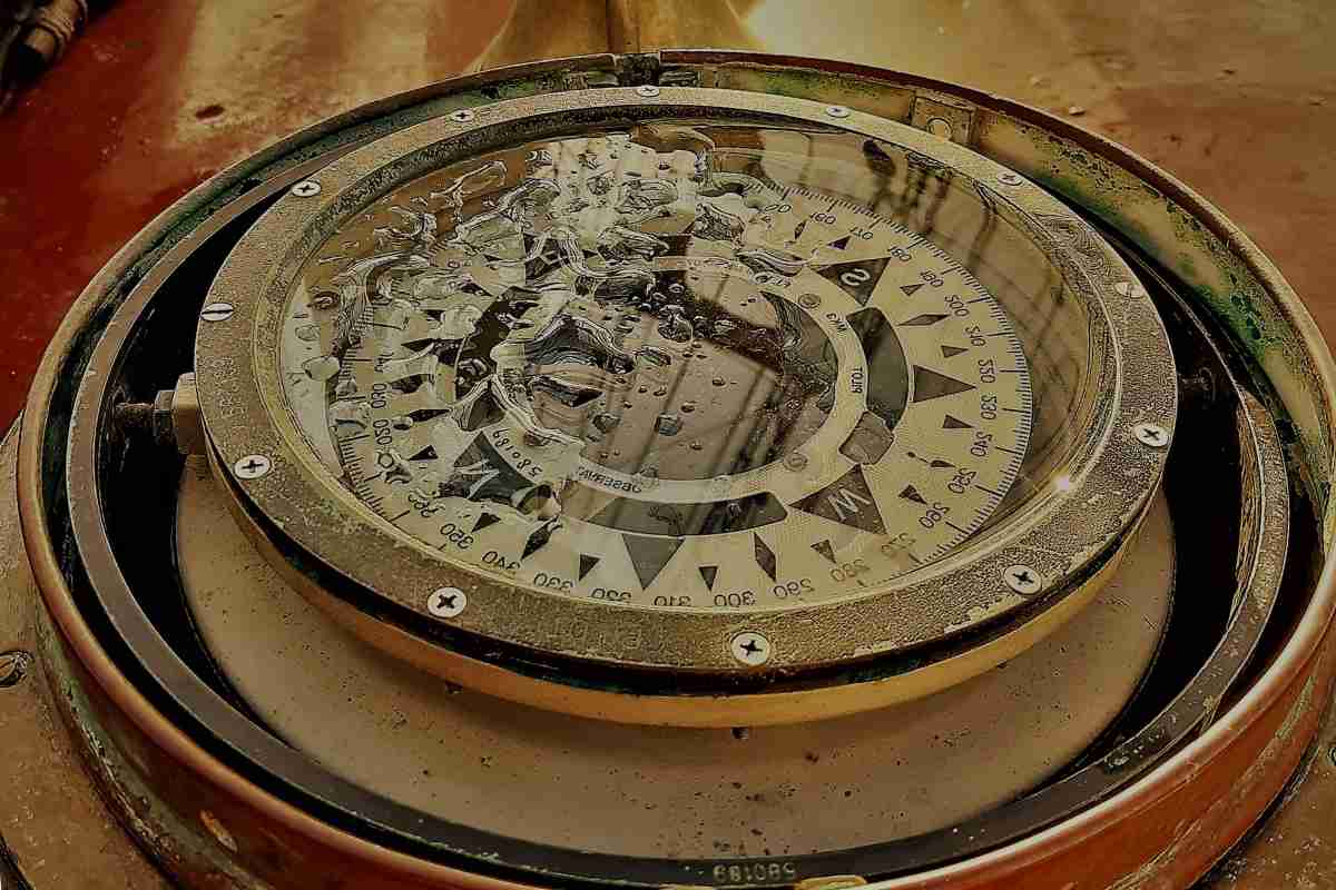
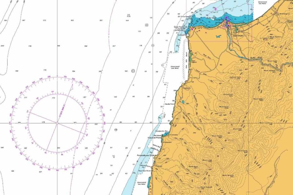
Chart with compass rose which indicates the variation for that year. A sailor is able to use the rose to make a heading taking into account variation.

History – A Story of Observation


Magnetism has been understood for thousands of years in some form and provides the foundations of magnetic compasses.

“The moment the metal comes near it, it springs towards the magnet, and, as it clasps it, is held fast in the magnet’s embraces… It received its name “magnes,” … from the person who was the first to discover it, upon [Mount] Ida… Magnes, it is said, made this discovery, when, upon taking his herds to pasture, he found that the nails of his shoes and the iron ferrel of his staff adhered to the ground.”– Pliny the Elder, The Natural History, completed 77 CE

The history of the magnetic compass extends back to antiquity where civilisations used lodestones, pieces of magnetic iron ore, predominantly for geomancy.
Whilst lodestones were not used for navigation at this time, people noted that magnetised metals pointed in two directions when moulded and suspended or when drifting in water.

From the 11th or 12th centuries it is believed Chinese scientists developed the magnetic compass for navigation with Western civilisations documenting its use in the 12th century.
The development over time included the design of the compass rose, which originally indicated 32 winds, and led to the mounting of a magnetised needle with a protective casing and set in gimbals on a binnacle – a common sight on ships today.

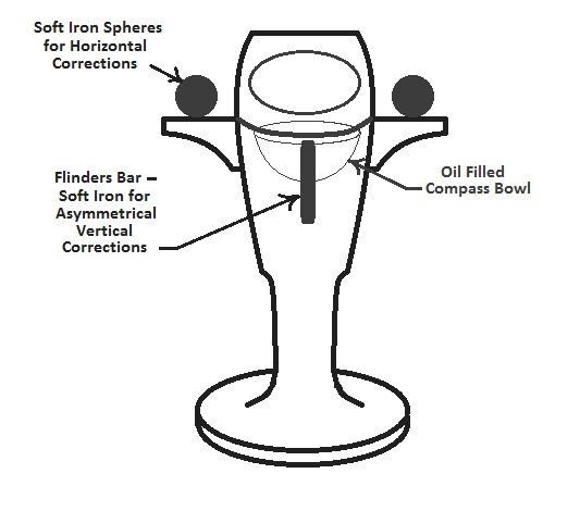
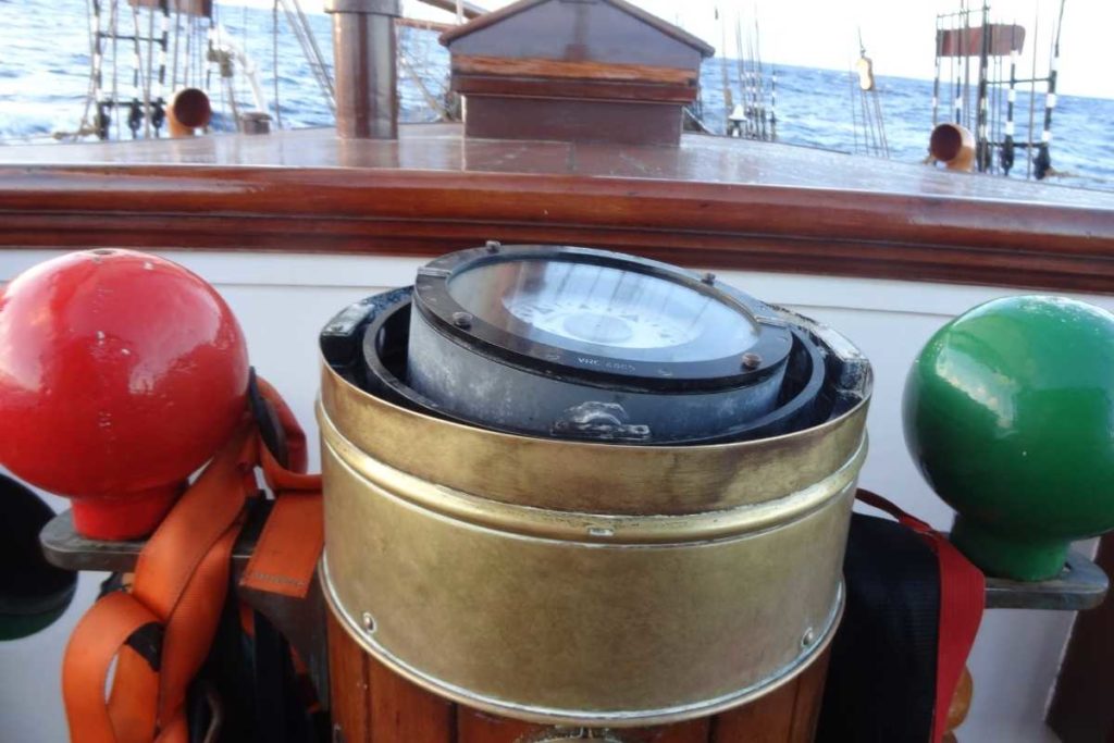
Ships compass in a binnacle. See the slight angle from the gimbal. Oosterschelde, H.Hurford.

Iron ships

The introduction of iron in shipbuilding presented a problem.
In the early 19th century, the deviation of the compass needle due to iron on board ships became obvious.

Iron hulled ships, first developed in the 1870s, caused such a disruption to their compasses, “that it was suggested seriously that such ships would never be successful for they would be quite unsafe in the absence of well-behaved compasses.” (The Oxford Companion to Ships and the Sea, Peter Kemp)

Matthew Flinders, a navigator and explorer, observed that deviation clearly occurred with the presence of the ships iron.
He also noted that when ships headed on courses east or west (literally deviating from the Earth’s magnetic rod) deviation occured, then disappeared when bearing north or south.
Flinders demonstrated how a ship’s magnetic effect could be neutralised by placing an unmagnetized rod of iron vertically near the compass.
This was called the Flinders’ Bar and is still used today.

Further designs were made to reduce the deviation of ships.
This included placing magnetised and unmagnetized iron in the vicinity of the compass, a method also used today.

 
Flinders’ Bar binnacle diagram
 
Use on a (steel) EcoClipper ship

Ships are now made of various materials and have access to a myriad of technologies which can plot courses, track movement, speed and automatically updates a ship’s location, all of which are used for navigation.
Many of these technologies are onboard for safety and are a requirement in international maritime law.

The EcoClipper500 will have a steel hull and deviation must be taken into consideration when installing the compass.
EcoClipper will predominantly use a magnetic compass for helming, with another posted in the Master’s cabin or similar.
The ship will also have other electrical navigational tools such as GPS compasses.

This is the beauty of the compass.
A physical tool that is so perfectly aligned with the Earth in its design, it can be simply adapted.
Yet it is also a symbol that provides consolation that however chaotic the world is around us; we can find a way forward and continue to our destination, wherever that may be.

Tuesday, June 14, 2022

It’s not too late to stop mass extinction in the ocean


Photograph: Giordano Cipriani/Getty Images

From Wired by Matt Reynolds

A quarter of a billion years ago, rising temperatures emptied the oceans of life.
The planet now faces a similar threat, but the outcome is in human hands.

A QUARTER OF a billion years ago, things were not going well on planet Earth.
That’s putting it mildly.
Back then the planet was in the middle of the worst mass extinction event ever—much worse than the one that wiped out the non-avian dinosaurs 66 million years ago.
During this earlier Permian-Triassic extinction event, some 70 percent of land species met their end.
Greenhouse gases released by volcanic eruptionsin Siberia poured into the skies, cooking the Earth and causing acid rain to fall back down onto the land.
Things were so grim that paleontologists have termed this mass extinction the Great Dying.

In the ocean, the situation was even more dire.
Temperatures around the tropics shot up by 10 degrees Celsius and deep-sea currents slowed down, which starved the oceans of oxygen.
Less than 5 percent of all marine species made it through the Great Dying.
It would take tens of millions of years for life in the ocean to recover from rock bottomand return to its previous levels of diversity.
Trilobites, a huge group of underwater creatures that had existed in the oceans for more than 250 million years, were wiped out altogether.
On land, the dopey-looking Lystrosaurus rapidly spread over the newly barren planet.

For oceanographers Curtis Deutsch and Justin Penn, the Great Dying can tell us a lot about where our present-day planet could be headed if we don’t get a handle on climate change.
“These environmental changes are also happening in the modern ocean today,” says Penn, a research associate at Princeton University’s Department of Geosciences and coauthor of a new paper published in the journal Science.
The overall oxygen content in the ocean has already fallen by around 2 percent since the mid-20th century.
This led Deutsch and Penn to a natural question: If greenhouse gas emissions precipitated ocean extinctions in the distant past, what level of extinctions might climate change lead us to?

To figure this out, the scientists looked at two future emissions scenarios.
In one of them, fossil fuel emissions rapidly increase—way beyond current expected trends—and lead to warming of around 4.9 degrees Celsius by 2100.
In the other scenario, lower emissions keep temperature increases to just under 2 degrees Celsius by the end of the century.
It’s worth noting that this high-emissions projection is an unlikely worst-case scenario—it would require huge increases in coal use, even though such activity peaked in 2013.
If countries stick to current policies, it’s more likely we’re headed for 2.7 degrees Celsius of warming, and if they uphold pledges made at COP26, humanity may be able to keep warming under 2 degrees Celsius.

“There is still a huge range of possible futures,” says Deutsch.
“We wanted to best bracket the plausible range of futures without being overly extreme in either direction.”

The scientists used these two emissions scenarios to estimate what would happen to oxygen demand and supply in the ocean.
Like us, marine animals need to breathe oxygen to survive, but higher temperatures reduce the amount of oxygen seawater can hold and slow down currents that would usually circulate oxygen between the surface and deep ocean.
At the same time, warmer temperatures increase the amount of oxygen creatures need to go about their business.
This increased demand and decreased availability of oxygen is thought to be one of the major reasons so many marine species died out during the Permian-Triassic extinction.

When Deutsch and Penn ran their models to find out how species would respond in the very high- and low-emissions scenarios, they found two dramatically different visions of the planet’s future.
In the very high-emissions scenario, the projected mass extinction rivals the severity of the previous “Big Five” extinctions in Earth’s past—including the Permian-Triassic extinction and the one that wiped out the dinosaurs.
But if warming stays at the levels estimated in the low-emissions scenario, the loss of species due to climate change should stay close to its current levels.

“You see us effectively sitting on the good side of a cliff,” says Douglas McCauley, a marine biologist at the University of California, Santa Barbara, who wasn’t involved in the Science paper.
But over the edge of that cliff there’s the potential for mass ocean extinction, he says.

These potential future extinctions won’t happen evenly over the planet.
Deutsch and Penn’s models predicted that marine species in the tropics are likely to move further north and south as oceans warm, while species already living close to the poles are at a higher risk of going extinct altogether.
We’re already seeing signs of this movement in today’s oceans, says Louise Rutterford at the University of Bristol in the UK.
In 2020, Rutterford coauthored an analysis that looked at where marine species could be found in the oceans.
She found that a species’ abundance tended to increase on the sides of its range that were closest to the poles and decrease on the side closer to the equator, suggesting that warming seas were forcing these animals to move away from the equator.

Species that already live near the poles are less likely to have somewhere they can move to when their oceans start warming.
That’s why in Deutsch and Penn’s model, poleward species tend to go extinct altogether while tropical species are more likely to move away from the tropics.
“You’ve got this potential for this changing of the guard,” says Rutterford.

Scientists know that this movement is happening today, but it’s hard to pinpoint how bad things are at the moment.
For a start, we don’t have a great sense of exactly what is happening in our oceans.
A lot of the best data on fish abundance comes from studies about commercially important fish species, such as tuna and pollock, while data from tropical species is much sparser.
“If you really want to find out what’s going on at the equator, we do need to have studies at the equator,” says Rutterford.

“There are quiet extinctions that are happening almost certainly in the oceans that are not being detected right now.
And that wave of undetected extinction is going to become a tsunami if climate change is allowed to advance,” says McCauley.

Even if we do get a handle on climate change, humans are still putting the oceans under extreme pressure due to fishing and changes to marine habitats.
In 2008, the International Union for Conservation of Nature reported that 22 percent of assessed marine species were under threat of extinction, including 17 percent of sharks and their close relatives.
One of the ways that governments and NGOs have agreed to protect the oceans is by turning vast swathes of them into marine protected areas—an oceanic equivalent to national parks.

“Marine protected areas are our best protection because in the face of the unknown they offer an ability for us to catch our breath,” says Katrina Davis, a conservation biologist at the University of Oxford.
In October, members of the United Nations Convention on Biological Diversity will meet to finalize their goals for protecting biodiversity on the planet.
One of the headline proposals is a plan to set aside at least 30 percent of terrestrial and marine areas as protected zones.
Protecting coastal areas is particularly important, Davis says, as that is one of the main places where humans and marine species come into conflict.

But marine protected areas will only be a temporary fix if we allow climate change to get out of control, says McCauley.
“You don’t want to be trying to solve local threats to diversity and just letting climate change undo all that in the future.” A return to the Great Dying is far from inevitable, but every fraction of a degree of warming that we can halt will reduce the severity of ocean extinctions.
“Our main result is that the magnitude of the future extinction depends on the CO2 emissions moving forward,” says Penn.
“That story is yet to be written.”
 
Links :

Monday, June 13, 2022

Self-captaining ships start their mutiny

The Mayflower Automated Ship didn’t reach its planned destination, but still completed an impressive, unmanned ocean crossing.
Photo: IBM

From Gizmodo by Lauren Leffer


The unmanned "Mayflower" made landfall in Canada and Hyundai's autonomous tanker vessel completed its first cross-ocean voyage.

The attempted autonomous vehicle takeover has reached the high seas.
 
Oliver Dickinson for IBM/Promare

Two different (at least partially) self-steering ships completed landmark journeys in the past few days. 
But both milestones come with big caveats: one encountered problems without any people aboard and ended up shortening its trip, and the other still relied on human judgement about half the time.


The completely crewless Mayflower Autonomous Ship (MAS400) docked in Canada on Sunday 7th.
The boat, partially funded by IBM, started out from Plymouth in the United Kingdom on April 27.


“After a 40-day and 3,500 mile journey, Mayflower Autonomous Ship successfully completed her mission to cross the Atlantic. She arrived in Halifax, Nova Scotia on Sunday 5th June,” said the project’s website.
However, the MAS400 was expected to land in Virginia, more than 1,200 miles southwest over land, and the vessel faced multiple mechanical difficulties throughout its ocean voyage.
 

The UK to Canada journey was the second attempt to get MAS400 across the ocean.
Its initial 2021 trip was scrapped because of technical issues.
Though this year’s voyage worked out better, there were still problems.
Early on, the vessel was diverted to the Azores in Portugal for in-person repairs after a switch failure. Then, there was an “issue with the charging circuit for the generator starter batteries” that kept MAS400 away from its original, planned destination, according to the boat’s own Linkedin page updates. 


Separately, on June 2, a massive tanker ship named the Prism Courage landed in South Chungcheong Province in South Korea after a 33 day journey from Freeport, Texas.
About half of that distance was navigated without the help of the vessel’s human crew, according to the Hyundai subsidiary, Avikus, which developed the steering technology. 

Avikus called the accomplishment the first of its kind.
The company further claimed that their automated HiNAS 2.0 system helped the boat avoid more than 100 collisions with nearby ships and that the trip was 7% more fuel efficient and emitted 5% less greenhouse gas because of the tech-optimized route.
 

The bulk of the Prism Courage’s path was across open ocean, but human navigation was still necessary near ports, in more crowded sea sections, and at chokepoints like the Panama Canal, according to a report by Engadget.
Regardless of the steering technology’s limitations though, Avikus intends to commercialize HiNAS 2.0 by the end of the year and expand beyond shipping to other vessels like cruise ships and yachts.
 

We may have Boaty McBoatface, but we don’t quite yet have an AI boaty mcboat brain powerful enough to manage all the challenges of the open ocean without some human help.

Links :

Sunday, June 12, 2022

Image of the week : intense low pressure system

Spectacular view of a deep low between Greenland and Iceland (Feb. 7th, 2022), pointed under 930 hPa.
We note a very extended train with a multitude of cumuliform clouds.