Saturday, March 21, 2020

Imray Laurie Norie and Wilson, cartographers

Tom Cunliffe visits the offices of Imray Laurie Norie and Wilson,
still making privately produced nautical charts after over 200 years.

Imray charts very soon in the GeoGarage platform
Original chart material comes from international Hydrographic Offices
Data come from a huge range of other sources too, which is what makes Imray charts and books unique.
Imray job consits to distill and present that mix in order to tailor it to yachtsmen and women.
ID10 North Sea
ID20 English Channel
ID30 West Britain & Ireland
ID40 Atlantic France, Iberia & Atlantic Islands
ID50 Western Mediterranean
ID60 Central Mediterranean
ID70 Eastern Mediterranean
ID80 Eastern Mediterranean
ID100 Eastern Caribbean


Friday, March 20, 2020

France & misc. (SHOM) layer update in the GeoGarage platform

279 nautical raster charts updated

Towards a radar-illuminated ocean

With over 4,000 kms of shoreline and some of the richest fishing grounds in the world off its coast, Chile is ranked globally as the eighth largest fishing nation.
Today, Chile took a stand to safeguard our Vibrant Oceans by working with Global Fishing Watch and Oceana to publish their vessel tracking data, which will help improve surveillance and encourage vessels to comply with regulations.

From GlobalFishingWatch by Brian Wong

At Global Fishing Watch, we use cutting-edge technology to visualize, track and share data about global fishing activity in near real-time and for free.
Our primary dataset comes from data about a vessel’s identity, type, location, speed, direction and more that is broadcast using the Automatic Identification System (AIS) and collected via satellites and terrestrial receivers.
We analyze AIS data collected from vessels that our research has identified as known or possible commercial fishing vessels, and apply a fishing detection algorithm to determine “apparent fishing activity” based on changes in vessel speed and direction.
The algorithm classifies each AIS broadcast data point for these vessels as either apparently fishing or not fishing and shows the former on our fishing activity heat map.
This allows us to currently track more than 65,000 fishing vessels.
The radar advantage

Our technology is revolutionary for tracking commercial fishing activity, but monitoring AIS still leaves a significant portion of global fishing activity from vessels that do not use the trackers unaccounted for.
What if we could see these unaccounted fishing vessels? What new research questions could we ask or fresh insights might be drawn from this new perspective? We’ve been exploring this idea using another form of cutting-edge technology, radar imagery from space.
Why radar? A physical property allows it to “see through” clouds.
Not having to deal with constant cloud coverage—typically two-thirds of our planet at any moment—provides a quicker pathway to discovering potentially interesting trends.
Check out the comparison of a radar and optical scene below.
Those bright spots in the red box are vessels otherwise covered up by clouds in optical imagery.


Unclassified radar detections

We’ve been developing methodology to automatically detect vessels from radar imagery.
However, our approach also detects non-vessel objects—typically fixed infrastructure like wind turbines and oil and gas platforms.
Below is a year’s worth of radar detections in the North Sea.
Clear transportation patterns jump out, but some more peculiar patterns are visible if you inspect close enough: the clusters in the box are oil and gas platforms, while the more geometric patterns pointed out by the arrows are wind farms.
Fixed infrastructure detection

To learn if the new radar data might elucidate new information unavailable via AIS, we needed to compare apples to apples, which meant filtering the radar detections to only vessels by removing all fixed infrastructure.
The fixed infrastructure would otherwise heavily bias the detections since they would likely be observed on every pass.
We hoped there was already an existing dataset to assist, and although disparate wind turbine and oil and gas platforms datasets were available, none met the requirements we needed.
So, we developed another method to map the fixed infrastructure in order to “subtract” it from the cumulative radar detections.

Specifically, we used the Gulf of Mexico, North Sea, and East China Sea to develop the methodology due to available ground-truth data.
These sites also allowed us to examine the generalizability of the method since two types of fixed infrastructure (oil and gas platforms and wind turbines) were included.
We drew on two strings of the literature for our methodology: a radar-based peak detection algorithm called CFAR and OpenCV’s blob detection (Rohling, 1983; Walt et.
al, 2014).

What does our algorithm do?
Check out the full methodology here in the paper, but its novelty can be observed by the drastic change from left to right plot below.
It maximizes the signal of the fixed infrastructure (wind turbines and oil platforms) yet concurrently minimizes the signal of the background ocean area.
This improves the detection of fixed infrastructure represented by those peaks.


Gulf of Mexico oil platform detection

Our algorithm included seven adjustable parameters.
It was unclear which combination would perform the best so we used Google Earth Engine to find the optimal parameters.
We tested 480 permutations further characterized in Table 1 of the paper.
Check out the top performing model results below.
It correctly detected 1,672 platforms (blue dots), incorrectly detected 46 objects (false positives in red), and missed 22 platforms (false negatives in yellow).


Wind turbine detection

Lastly, we tested our algorithm across a few wind farms (1,954 total individual turbines) just north of Shanghai, China and the North Sea since nearly all of the objects in the Gulf of Mexico were related to oil and gas.
The area zoomed in below shows the output of our algorithm—the red dots—superimposed in the right half.
You can still see the individual wind turbines on the left.


Towards a global fixed infrastructure dataset

Below is the same North Sea area with one key change.
Both the wind turbines and oil platforms are now mapped separately in white.
The aforementioned experiment was nice, but we want to do this at scale so we’re currently refining a global version.
We plan to classify these stationary objects as well.


Monitoring our vast oceans is both incredibly challenging and rewarding—our public fishing effort map demonstrates the positive impact of what planetary scale environmental data science can have, but we’re always seeking to facilitate new discoveries.
Mapping offshore infrastructure is one small step in this quest, and we’re even finding that scaling up from the regional work to the global version has presented new challenges—one of the more interesting hurdles is a radar-specific issue called range and azimuth ambiguities.
If you’ve got a geospatial solution to map these ambiguities, we’d love to hear from you.

This work was done in collaboration with SkyTruth and Duke University’s Marine Geospatial Ecology Lab.

Links :


Thursday, March 19, 2020

Will ocean seabed mining delay the discovery of potential Coronavirus vaccines?


From Forbes by Nishan Degnarain

Last week saw the most unprecedented reaction to a global health crisis in modern times.
The World Health Organization declared COVID-19 a global pandemic, the US President announced a National Emergency that released $50 billion in federal funding, Italy introduced a national quarantine, over 145 countries (and rising) now have recorded cases, travel restrictions are in place in every country around the world, and the New York Federal Reserve announced a $1.5 trillion intervention to stabilize markets.

Most countries are either in the containment phase of the disease (i.e., test, identify and isolate cases) or the mitigation phase (i.e., delaying the spread and ensuring business continuity measures).

At the same time, the race is now on to develop a COVID-19 vaccine, ahead of any second wave of infections later this year.

The speed with which a vaccine is developed depends on many factors (e.g., the success of pre-clinical trials, animal testing phases, human clinical trials, and production scale up).
Advances in biological technology (such as gene-editing CRISPR and cell free protein synthesis) is accelerating the time to vaccines and treatment development.
However one critical element is still needed.
That is the initial step to find the biological clues which lead to the high potential chemical compounds that could reduce the potency of COVID-19.

Many of these high potential chemical compounds come from natural sources, so modern medicine will need to return to the wild to find them.

Solutions from the deep ocean?

Last week among the COVID-19 headlines, David Attenborough made a plea calling for Deep Ocean Seabed Mining to be banned.
One of the reasons he cited was the importance of deep water corals and microscopic microbes at the bottom of the ocean.

It turns out, these are extremely valuable for modern medicine, including addressing coronaviruses.

A protein from an ocean seabed algae found among coral reefs was revealed to show activity against another coronavirus known as Middle East Respiratory Syndrome or MERS.
MERS is a close relative of the coronavirus responsible for COVID-19, and was responsible for an outbreak in the Middle East in 2012 that infected almost 2500 people, leading to over 850 deaths in 27 countries (34% fatality).
This marine compound griffithsin was extracted from the red algae Griffithsia that is native to coral reefs around the Canary Islands and identified in 2016 to be a potential inhibitor to the MERS coronavirus.

Diver overlooking a large orange elephant ear sponge (Agelas clathrodes), Curacao, Netherlands ...
Universal images group via Getty Images

This is just one of over forty marine compounds that have anti viral properties and are undergoing pre-clinical and clinical trials around the world (such as another coronavirus inhibitor from the ocean sponge axinella corrugata found in the Caribbean).
These are all at the early stage of vaccine discovery, but help researchers identify areas of high potential.
Having such a library of high potential chemical compounds from nature against coronaviruses, could have greatly accelerated progress for vaccine development ahead of time among the several major companies working on these solutions.
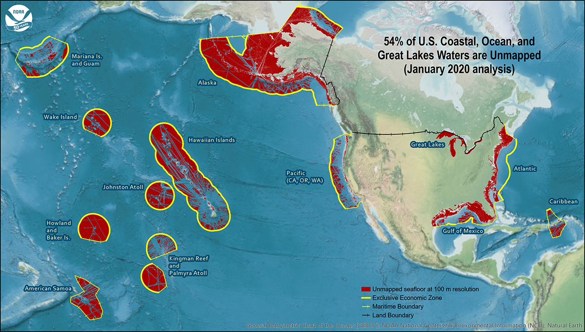
Yet, less than 0.05% of the deep ocean has been visited, photographed or sampled.
We are just learning the true potential and value of life in the deep ocean.

Being able to sample marine wildlife is critical to identify more potential targets to address threats such as the coronavirus in the future.
Not all will come from the ocean, but natural products will be a crucial part, given that COVID-19 jumped the species barrier to impact humans.
Indeed, the WHO has called the Climate Crisis a Health Crisis, and as the ocean warms, the risks to humans rise with more novel diseases and less biology with which to help combat them.

It is important that we are able to catalogue these environments before these ecosystems and their complex biology are lost forever.

Valuable medicines from the deep


Atlantic Ocean: Black smoker hydrothermal vent at a mid-ocean ridge.
Universal images group via Getty Images

Selective pressures - the unique conditions under which lifeforms evolve - are no more extreme than at the bottom of the deep ocean.
Life here has evolved to live at extraordinary pressures, temperatures, and chemical environments.
This means that deep sea creatures have evolved distinct genes, which encode proteins, which in turn catalyze unusual chemistry or possess other useful properties.
These unique marine genetic resources are the product of evolution over timescales and in conditions which humans cannot replicate.

Marine genetic resources are therefore irreplaceable products of nature that play a critical role in modern medicine and industrial processes today.
Take a look at any major disease and often the highest potential treatments have their origin in a marine natural product.
For example:
A treatment for advanced breast cancer developed by the Japanese Pharmaceutical company Eisai, was derived from the marine sponge natural product called eribulin.
The drug - called Halaven - has prolonged numerous lives, generated over $500 million in annual sales since 2015, and is now approved in over 65 countries.
Eribulin is found in the marine ‘breadcrumb sponge’ called halichondria, that is prevalent in the North Atlantic, Mediterranen and around New Zealand at a depth of 500m.
The first effective HIV treatment was azidothymidine (better known as AZT).
This is a variant of a chemical compound made from a marine sponge in the Caribbean called tectitethya crypta.
It generated $4 billion in sales alone and in combination with other anti-HIV drugs, since being approved by the FDA in 1987.
Infectious diseases are increasingly drug-resistant, and medical science is constantly battling to stay ahead.
Organisms that cause malaria and tuberculosis can be killed by marine-derived compounds such as cyclomarin.
Cyclomarin comes from an ocean bacteria called salinispora arenicola first identified around islands in the Bahamas in 1991.


Exhaust rises from a coal-fired power station on in Schophoven, Germany on January 21, 2019 .
Getty Images

In addition to medicine, the biology from the deep ocean is valuable for industrial purposes, especially cleaning up pollution and environmental remediation, which will be critical to restore our planet to a healthy ecosystem.
A recently discovered deep sea microbe in 2014 from 2km depth in the Indian Ocean, nesiotobacter exalbescens, efficiently degrades hydrocarbons (benzene and toluene which are common soil and water pollutants), and is therefore a potential tool for environmental cleanup, especially oil spills in the ocean.

A bacteria discovered in the deep sea can clean contaminated soil and water from the toxic mercury pollution caused by coal power plants.
The alcanivorax bacteria was discovered at 2km depth on the East Pacific Rise in the Pacific Ocean, close to where Seabed Mining is due to begin in the Clipperton Zone.
This bacteria converts mercury salt into a less harmful form of the metal, and along with the metal reducing bacteria living on and in metal polymetallic nodules, may enable the remediation of the millions of square kilometers of mercury-contaminated soil and water that surround coal-power stations across the USA and China that make agriculture grown there not fit for human consumption.

An enzyme which copies pieces of DNA, was discovered in a microbe living on a deep-sea hydrothermal vent off the coast of Italy.
It has been turned into a product by New England BioLabs and sold commercially.
The enzyme’s evolution under extremely hot and high-pressure conditions makes it more stable, and a more effective approach to copy DNA than its relatives in other species, rendering it a valuable tool for molecular biologists.

These are just a handful of medical and industrial examples of a world that humans have only just begun to explore and understand, as new technologies open new biological frontiers in the sustainable blue industrial revolution.

A habitat at risk


The Mafuta diamond mining vessel, operated by Debmarine Namibia, a joint venture between De Beers ...
© 2017 Bloomberg Finance LP

2020 was supposed to be the biggest year for the environment, with major UN negotiations to protect our oceans, biodiversity and the climate.

Some of these talks around the importance of life in the oceans (the Biodiversity Beyond National Jurisdiction Treaty or BBNJ), has now been postponed to later in the year.
The BBNJ treaty was supposed to create a framework to ensure such life in the deep ocean is protected and valued, rather than be put at risk by extractive industrial activities.

At the same time as countries are recognizing the value of deep ocean species, seabed mining companies are lobbying countries to allow them to mine the deep ocean seabed for mineral resources.

A Jamaica-based UN Agency called the International Seabed Authority was due to vote on a legal framework in July 2020 to authorize such commercial mining.
It was against particular countries voting at this agency that David Attenborough voiced his opinion.

Scientific outrage

The prospect of starting commercial scale Seabed Mining in 2020 has been to the outrage of leading ocean scientists, civil society and major environmental NGOs, who fear an unprecedented loss of biodiversity and weak regulatory oversight.
They are calling for a ban or at the very least, a ten year moratorium on any such commercial operation, until science has sufficiently advanced to understand deep ocean environments.

There are many environmental uncertainties with seabed mining, which would devastate deep ocean habitats and the valuable life that inhabits them.

Life around hydrothermal vents were only discovered 43 years ago in 1977, which completely overturned theories of how life evolved on Earth.
Yet, mining will be allowed around such communities in the Indian and Atlantic Oceans.
Following a trial of experimental Seabed Mining off the coast of Peru in 1989, a quarter of a century later, almost 80% of life had not returned, revealing the extent of permanent damage seabed mining would do to life in our oceans.
This includes loss of the valuable microbial colonies that are powerful for new medicines and sustainable industrial processes.

In addition, there is great uncertainty around the toxic cloudsof sediment around mining operations, called plumes, that will rise up around any deep ocean machinery as excess sediment is discarded away from the mined metals.
Seabed nodules grow 10mm every 10 million years in very delicate ocean environments.
Hence Seabed Mining companies’ plans to remove 4cm of seabed sediment implies destroying 40 million years of evolutionary history.
This is in addition to any noise and other permanent damage being done by dredging up the seabed as is planned for the Pacific Ocean.

Hence, it is critical that the world has time to study, identify and categorize the unique life on the deep ocean floor before they are lost forever.

Valuing ocean life over minerals and profits


Children release sea turtle hatchlings at sunset in Lhoknga beach of Aceh province on January 31, ...
AFP via Getty Images

Given that the consequences of COVID-19 are estimated to cost the global economy as much as $3 trillionin 2020 (over $8 billion a day, or over $5.5 million a minute), every moment counts in developing effective treatments.
There is no seabed mineral more valuable and unavailable on land that justifies such a planetary risk.

The current coronavirus crisis shows just how important it is to have a library of deep ocean natural resources, including deep ocean microbial communities.
It is critical to ensure we have a large enough repository of natural product targets to be prepared for the next health pandemic crisis.
This could save precious months to identify high potential compounds and develop effective vaccines, saving the global economy hundreds of billions of dollars.

Advances in deep ocean exploration, machine learning and biotechnology to better understand natural products, are all significantly accelerating our understanding of nature and potential medical and industrial applications.

The COVID-19 crisis has been a wake-up call for so many aspects of global governance.
The world will be irreversibly changed after this crisis.

The activities we permit to occur in our oceans are yet another area where the world needs to turn its attention to, but this time with much more consideration.

Louis Metzger, Ph.D. contributed to this article, particularly with his knowledge of infectious disease research and the role that micro-organisms will play in the transition to a sustainable economy.
Dr. Metzger was formerly a Group Leader and Project Team Leader in Novartis’ Infectious Diseases Unit, where his team sought new antimicrobial molecules for drug discovery, including from Natural Products.
He is now the Chief Science Officer of a BioTechnology startup.

Links :

Wednesday, March 18, 2020

NOAA announces new progress report on mapping U.S. ocean, coastal, and Great Lakes waters


Geographic distribution and extent of the unmapped areas within U.S. ocean, coastal, and Great Lakes waters.
Analysis conducted in January 2020. 

From NOAA

OAA released the first annual report on the progress made in mapping U.S. ocean, coastal, and Great Lakes waters.
The depth, shape, and composition of the seafloor are foundational data elements that we need to understand in order to explore, sustainably develop, conserve, and manage our coastal and offshore ocean resources.
The 2019 Presidential Memorandum on Ocean Mapping of the United States Exclusive Economic Zone and the Shoreline and Nearshore of Alaska and the global Seabed 2030 initiative make comprehensive ocean mapping a priority for the coming decade.
The Unmapped U.S. Waters report tracks progress toward these important goals.
 
“The progress made in mapping U.S. waters through 2019 represents the cumulative work of federal and state agencies, nongovernmental organizations, private contracting partners, and crowdsourced contributions,” said Rear Adm. Shep Smith, director of NOAA’s Office of Coast Survey. “Partnerships and advances in technology are key to making significant progress toward our common goal of completely mapping U.S. waters.”

Pulling from an analysis of publicly available bathymetry, the report presents the percentage of unmapped U.S. waters by region and shows our progress towards filling these basic bathymetry data gaps with each passing year.
At the end of 2019, the latest analysis yielded the following results:

Percent of U.S. waters that remain unmapped in 2019:
  • U.S. total – 54% of 3,592,000 square nautical miles (snm)
  • Atlantic and Gulf of Mexico – 43% of 472,200 snm
  • Great Lakes – 95% of 46,600 snm
  • Caribbean – 42% of 61,600 snm
  • Alaska – 72% of 1,080,200 snm
  • Pacific (California, Oregon, Washington) – 24% of 239,700 snm
  • Pacific Remote Islands and Hawaii – 50% of 1,691,700 snm
 Multibeam and lidar surveys are the two primary sources of bathymetry needed to fill these gaps.
In support of the integrated ocean and coastal mapping goal to “map once, use many times,” all of the data collected in this effort are publicly available to benefit numerous user communities.
For the latest status on these efforts and how you can contribute, visit :
http://iocm.noaa.gov/seabed-2030.html.

Unprecedented data confirms that Antarctica’s most dangerous glacier is melting from below

Researchers needed to drill through nearly 2,000 feet of ice to measure water temperatures where the Thwaites Glacier first connects with the ocean.
(Jeremy Harbeck/NASA/OIB)

From The Washington Post by Chris Mooney

Warm ocean water has been discovered underneath a massive glacier in West Antarctica, a troubling finding that could speed its melt in a region with the potential to eventually unleash more than 10 feet of sea-level rise.
The unprecedented research, part of a multimillion-dollar British and U.S. initiative to study the remote Thwaites Glacier, involved drilling through nearly 2,000 feet of ice to measure water temperatures in a narrow cavity where the glacier first connects with the ocean.
This is one of the most difficult-to-reach locations on Earth.
At a region known as the “grounding line,” where the ice transitions between resting on bedrock and floating on the ocean, scientists measured water temperatures of about 0 degrees Celsius (32 degrees Fahrenheit).
That is more than 2 degrees warmer than the freezing point in that location, said David Holland, a New York University glaciologist.
He performed the research with Keith Nicholls of the British Antarctic Survey.

“That is really, really bad,” said Holland.
“That’s not a sustainable situation for that glacier.”
Scientists already knew that Thwaites was losing massive amounts of ice — more than 600 billion tons over the past several decades, and most recently as much as 50 billion tons per year.
And it was widely believed that this was occurring because a layer of relatively warmer ocean water, which circles Antarctica below the colder surface layer, had moved closer to shore and begun to eat away at the glaciers themselves, affecting West Antarctica in particular.
But that had not been directly confirmed because Thwaites is gigantic (larger than the state of Pennsylvania) and exceedingly difficult to reach.
“The biggest thing to say at the moment is, indeed, there is very warm water there, and clearly, it could not have been there forever, or the glacier could not be there,” Holland said.

A joint U.S.-British research team has discovered warm ocean water beneath the Thwaites Glacier in remote West Antarctica.
(David Vaughan, British Antarctic Survey)

Thwaites is the most worrying glacier in Antarctica because of its size — it is unusually wide, presenting a 75-mile front of ice to the ocean, without any rocks or mountains to hem it in.
This means very large volumes of ice could break off and flow uninhibited through this region into the sea.

Even worse, Thwaites gets deeper and thicker from its oceanfront region back into its interior in the heart of West Antarctica.
This is known to be an unstable configuration for a glacier, because as the ocean continues to eat away at its base, the glacier becomes thicker, so more ice is exposed to the ocean.
In turn, that ice flows outward faster.
Scientists call this “marine ice sheet instability.”
Researchers believe that as recently as some 100,000 years ago, West Antarctica was not a sheet of ice at all — but rather, an open ocean that later converted to glacier.
The fear is that the melting now taking place could lead to a return to open ocean.
Granted, it would still take a very long time to melt all of that ice, but there’s a fear that it could begin in a substantial way in our lifetimes, worsening sea level rise.
Because Thwaites is so vast, the measurements were confined to a region known as its eastern ice shelf, where a floating part of the glacier is 600 meters (nearly 2,000 feet thick) and underlain by just 40 meters (about 130 feet) of water.
Scientists drilled through the ice using a technique known as hot-water drilling, and then extended an instrumented cable to take measurements in the ocean cavity.

Scientists used hot water drills to reach ocean water beneath the Thwaites Glacier.
(Courtesy of David Holland, NYU’s Courant Institute of Mathematical Sciences)

They also detected turbulent water in the area, suggesting that saltwater and freshwater are swirling together as the ice melts.
This process may draw the warm water in toward the glacier and speed the losses.

“The key here is that they drilled very close to the grounding line,” said Eric Rignot, a researcher with NASA and the University of California who also studies Thwaites closely and commented on the findings.
“We do not know much about ocean-ice interaction in that narrow part of the cavity, yet this is the crucial part for ice dynamics, glacier stability, fast retreat."
“Is the water moving around and releasing heat to the ice efficiently, is it stagnant instead?” Rignot continued.
“Our sense from remote sensing is that it is not stagnant but very actively melting ice.
So having temperature measurements in that narrow part is essential.”
Rignot said the water is probably even warmer in other regions of Thwaites, which could retreat even faster than the spot where the measurements were taken.

Nicholls of the British Antarctic Survey said in an email from Antarctica that the relatively warm water they discovered was actually “associated with low (for the area) melt rates because of the low currents.” Still, he too affirmed the water was more than warm enough to melt ice.
Climate change is believed to be shifting winds around Antarctica, which in turn are connected to a warming of the tropics and shifting patterns of atmospheric circulation.
The winds drive ocean currents, and the change has meant that the warm offshore layer, called circumpolar deep water, has been pushing in closer to shore, where it can melt ice.
Scientists say there is much more to learn about this process, but the most important fact is clear — warm water is causing Thwaites to melt and retreat.
“This is the first verification ever of warm water at a grounding zone on the Thwaites Glacier, arguably the most important one in West Antarctica,” said Holland.
“So the pieces fit.”

The ice front of Thwaites Glacier.

Tuesday, March 17, 2020

For the first time ever, travelers can join an expedition to the deepest spot in the oceans

Diving to Challenger Deep: Three travelers now have a rare opportunity to take part in an expedition to the deepest point in the oceans -- Challenger Deep. 
They'll ride in the 11.5 tonne DSV "Limiting Factor," which is the only certified vehicle in the world that can repeatedly dive to any depth in the world's oceans.
Reeve Jolliffe/EYOS Expeditions


From CNN by

Once upon a time, reaching the highest peak on Earth was considered a feat achievable only by a select few.
Fast forward to today.
Though it remains a costly endeavor -- and sometimes deadly -- it's logistically easy enough to arrange.
Over 4,000 adventurers have climbed to the top of Mount Everest, according to the British Mountaineering Council.
So what's an intrepid amateur explorer with a thirst for all things rare and superlative to do?
Travel in the opposite direction, of course, to Challenger Deep.

The mothership: The rare experience is being offeered by EYOS Expeditions.
The DSSV Pressure Drop serves as the expedition's purpose-built 'mothership' and primary operations platform.

Sitting at a depth of 10,928 meters (35,853 feet), it's widely believed to be the deepest point in the world's oceans.
In a world-first, travel company EYOS Expeditions has teamed with private undersea diving company Caladan Oceanic to offer general members of the public an opportunity to join an upcoming expedition and dive to the bottom of the Marianas Trench in the western Pacific Ocean.


Science landers: Prior to each dive, this lander is launched.
It sends back detailed reports on ocean conditions at depth, and acts as a communication and navigation aid.

How rare is this experience?
According to EYOS, only seven people on earth have visited Challenger Deep.
(Hollywood director James Cameron just happens to be one of them.)
Here's the catch: The company is only inviting three people to join the trip.
Staff tell CNN Travel it's being offered on a first-come, first-serve basis, and they aren't releasing any details on the cost.
But it's safe to assume it will be a minimum of $100,000, given dives to the Titanic were expected to cost travelers between $100,000-$200,000 per person.


Post-dive: Expedition leader Rob McCallum departs to recover Limiting Factor at the end of another successful dive during last year's Five Deeps Expedition.

Four hours on the sea floor 

The three travelers, called "Mission Specialists," will spend approximately eight days with the Ring of Fire Expedition, which is operated by EYOS and Caladan Oceanic.
Each submarine dive will take up to 14 hours.
The descent, which is over seven miles, takes over four hours.
The divers will spend up to four hours on the seafloor, where they will get to explore and potentially film their surroundings.


Total focus: A recovery in oceanic conditions requires both dexterity and concentration.
 Record-setting dive: DSV Limiting Factor is positioned for recovery after the completion of her world record dive to 10,924 meters in 2019.
"This is the most exclusive destination on Earth," says Rob McCallum, founding partner of EYOS Expeditions, in a statement.
"Currently, only three manned expeditions have ever been made to the bottom of Challenger Deep and more people have been to the moon than to the bottom of the ocean."
The Mission Specialists will board the hadal exploration vessel, DSSV Pressure Drop, in June 2020 -- EYOS says the exact date is to be confirmed -- in Agat, Guam.
It then takes a day at sea to reach the Marianas Trench.


DSSV Pressure Drop: The three lucky "Mission Specialists" will board the hadal exploration vessel, DSSV Pressure Drop, in June 2020 in Agat, Guam.
After a day at sea they'll reach the Marianas Trench.
 Long way down: The DSV Limiting Factor fills her ballast tanks and prepares to dive to full ocean depth.

The expedition will use Caladan Oceanic's submersible, Limiting Factor, which has been pressure tested in a chamber to 14,000 meters and has already dived five times to the bottom of the Mariana Trench.
EYOS says it's the only vehicle ever constructed that is capable of multiple dives to full ocean depth.
"The occupants of the submersible are completely protected by the 90mm thick titanium sphere and experience no pressure changes or physiological stresses at all," says the statement announcing the trip.


Team shot: The Five Deeps Expedition team made history in 2019 by completing a helical circumnavigation of the globe to dive at the deepest point in each ocean.
JamesBlake/EYOSExpeditions

Comfy seats, hi-def cameras
As a result, no formal pre-departure training is required, though Mission Specialists will receive a comprehensive shipboard and sub orientation as part of pre-dive preparations.
"The inside of the sub is quiet, peaceful and very relaxing. The sub has two comfortable seats, three view ports, and high-definition 'surround' cameras," says McCallum.
"Whilst onboard, Mission Specialists will be fully integrated members of the team and free to work alongside our sonar operator/ocean mappers, submersible technicians, film production team, expedition management and ship's officers to gain an insight into the complexities and challenges of hadal exploration," he says.


Pre-dive rehersals: Every new dive is 'rehearsed' at a full team meeting that draws in the collective expertise of the captain, sonar operator, scientist, sub team and expedition leader.
New discoveries: Chief Scientist Alan Jamieson examines samples recovered from many thousands of meters below the sea during the Five Deeps expedition.
Virtually every dive yields new discoveries, say EYOS team members. 

Don't worry.
Even intrepid explorers need some down-time, too. McCallum says when not diving, expedition members can relax by taking in a movie, going to the gym, reading, or heading up to the "Sky Bar" for a sundowner.
The dive is part of a much longer six-month Ring of Fire expedition EYOS and Caladan Oceanic are operating, a followup to the Five Deeps Expedition made last year, which visited cavernous chasms in the Pacific, Indian, Southern, Arctic and Atlantic oceans over a period of 10 months.
"Its collective mission is to verify and test the deepest points possible, collect and analyze scientific samples, and extend humankind's knowledge of the most extreme environment on Earth, says Ben Lyons, EYOS Expeditions' CEO.

Interested in joining?
Contact EYOS Expeditions for pricing and further info...

Links :

Monday, March 16, 2020

To see the sea: achieving total maritime situational awareness using VHR satellite imagery


Highly Automated Beach Litter Analysis Using Very High Resolution Satellite Imagery and Machine Learning
Traditionally it has been a human user who analyzes satellite imagery for changes, but this process is slow and time-consuming.
Whether detecting trash on beaches or monitoring forest health, there is huge potential for computers, through the use of machine learning, to do the job faster and better than humans.
Tama Group is using The eCognition software along with 30 cm Very High Resolution Satellite Imagery supplied by European Space Imaging to detect trash on beaches and generate a map that can be used by clean-up officials and organisers.

From GIM

The ocean is a precious resource that all Europeans make use of in one way or another.
Over 200 million of us live near the sea, and even people who dwell inland benefit from using it for transport, food or leisure.
The following article gives an overview of maritime projects that have benefited from the use of very high resolution (VHR) satellite imagery.

Protecting this natural resource is complex and multi-faceted; it must be kept healthy while sustainably supporting the different businesses and individuals who rely on it, and who often have conflicting needs.
Additionally, it is under threat from pollution, climate change, flooding, erosion, sea-level rise, extreme weather events, and overfishing.

There is a growing need for coverage and detection of large maritime areas, mainly in the exclusive economic zone (EEZ).
Since physically accessing such a large area is practically impossible, satellite-based sensors offer an efficient and cost-effective solution.

By combining these data sources with artificial intelligence and machine learning, further insights can be gained autonomously and in a timelier manner.

For example, radar data of a large ocean area can be obtained from a satellite and run through an AI program to automatically identify potential vessels.
This results in the identification of a specific geolocation of the vessel so that a Very High Resolution (VHR) optical satellite image can be obtained.
The VHR image then provides the level of detail needed to identify the object in the water.
This process is known as tipping and cueing.

Example of SAR imagery combined with VHR imagery.

This story will give a good impression of maritime projects that have benefited from the use of VHR satellite imagery.

Anti-drug Trafficking Operations in the Mediterranean

In May 2017, The Maritime Analysis and Operations Centre – Narcotics (MAOC(N)) believed that a known vessel had been involved in a transshipment of heroin.
The location of the transshipment was not known, but although the vessel was not reporting its position, it was believed that it was somewhere in the Suez Bay.

In support of live operational activity, a request for optical satellite imagery was directed to Copernicus Maritime Surveillance and the order was fulfilled by European Space Imagery.
The delivered products allowed operators to confirm that the vessel was no longer in the Suez bay and it was heading north.
This information was shared immediately with the Turkish authorities, who intercepted the vessel, arrested nine crew members and seized more than 1 ton of heroin.

Whales Held in Captivity in Russia

In February 2019 it was alleged that Russia had illegally captured eleven killer whales and were holding them in Srednyara Bay along with 87 belugas.
Four Russian companies that supply marine animals to aquariums had caught the whales during Summer 2018.
To verify the existence of the “whale jail” a series of satellite images at 30 cm were captured.

VHR image of whales held in captivity in Russia.

Very High Resolution imagery is being utilized internationally by both maritime surveillance agencies and animal rights groups to shed light on illicit fishing operations and aid in legal proceedings,” said European Space Imaging Managing Director, Adrian Zevenbergen.
“In these images captured by WorldView-3 in late February, a number of whales can be seen inside the pins, which may provide crucial evidence as international criminal investigations move forward.”

In addition to receiving extensive media coverage, a criminal investigation was launched.
In April 2019 the Russian Government in partnership with two American NGO’s announced that all 97 whales would be released back into the wild.
This was completed in November 2019.

Major Oil Spill in the Mediterranean

In October 2018 two cargo ships collided north of the island of Corsica causing upwards of 600 tons of fuel to be leaked into the Sea causing an oil slick 50 m long.
In accordance with emergency management, maritime regulation and environmental protection efforts, detailed maps and models were required immediately to begin the processes of cleaning up the accident.

Emergency orders were placed with European Space Imaging who then scheduled the WorldView-2 satellite to capture images at 50 cm resolution over the site of the accident.
These images were delivered to French and Italian maritime authorities within hours.
From the data, oil drift and fate predictions were able to be simulated and it was determined that the coastlines of Italy, Monaco and France were at risk of oil pollution in the days after the incident.
This allowed officials to preemptively respond in coastal areas and dispatch clean-up vessels ahead of the drifting oil.
The oil was, therefore, able to be controlled and cleaned faster and more comprehensively.

Corsica oil spill overview with close up of the ship and oil spill drift.

"Satellite remote sensing plays a very strategic role in maritime surveillance and supports the entire response process, from providing initial detection and assessment for situational awareness to directing clean-up efforts" said Dr.
Melanie Rankl.
"Very High Resolution satellite imagery is an additional asset to that of traditionally used radar-based oil spill detection technology.
Its ability to provide a detailed overview of the area plays a complimentary role in conducting on-going assessments and monitoring the extent of damage."

Highly Automated Beach Litter Detection

Each year ocean trash kills over one million birds and 100,000 mammals and turtles.
Satellite imagery is already an essential tool in locating objects and debris in large or remote areas however this study aimed to prove that Very High Resolution satellite imagery could be used in combination with artificial intelligence to streamline litter detection processes.
Partnering with Tama Group, European Space Imaging was able to supply 30 cm Very High Resolution WorldView-3 imagery for a proof-of-concept study straight from its archive.
A single pixel in a 30 cm satellite image will depict 30×30 cm of whatever was on the ground when the image was taken.
This means a beach towel is big enough to be seen clearly by the naked eye, but a child’s bucket and spade on the sand is probably not – except perhaps in a slight change of the pixel’s color when compared to its neighbors.
A change that is very difficult to interpret, and to spot.

eCognition overlaid VHR imagery to detect litter on Italian Beach.

“The trash we find on beaches is typically a diameter of 10cm and maybe a pixel size long,” Ralph said.
“And so we had to take a statistical approach – if there are litter candidates in pixels of that size, at a certain amount of trash it starts looking like a signal.
The first part of this exercise was figuring out if it is technically possible to detect this at all.”

Using eCognition, the satellite data was stacked with additional layers containing information gathered from experts on marine litter.
Once the programming of the parameters was complete, the process was designed to be 100% automated.
After the analysis of the first two WorldView-3 images the machine came up with 27 pixels marked as litter candidates, a result that is promising based on a visual inspection of the data.
The future hope of this discovery is the integration of the technology into regular monitoring services for government of tourism organizations.

Example of vessel detection and identification.

Conclusion

European Space Imaging has over 15 years’ experience working closely with a number of maritime authorities and private companies.
Whether it is delivering archive data or planning fresh acquisitions, the team is available to assist a wide range of maritime application projects to ensure total maritime awareness is achieved.

Sunday, March 15, 2020

420 and Ultim in the breeze

Tommaso Cilli and Bruno Mantero in their work, planning in the breeze, at full speed under spinnaker.

Watch this spectacular footage of the 130ft maxi trimaran Spindrift 2 as she sails from France on her fourth attempt to break the non-stop round the world record.
The pace the 11 crew have to better is an incredible average speed around the world of 22.8 knots!