Saturday, November 27, 2021

7 ROV findings from the Marianas Trench


Over the past decade, deepwater ROV expeditions have provided an unprecedented amount of insight into the Marianas Trench-- including the Challenger Deep, the deepest place on Earth.
These are seven of the most interesting discoveries made in the Marianas Trench.

Friday, November 26, 2021

These Maldives islanders once saw sharks as the threat. Now they fear the plastic

 
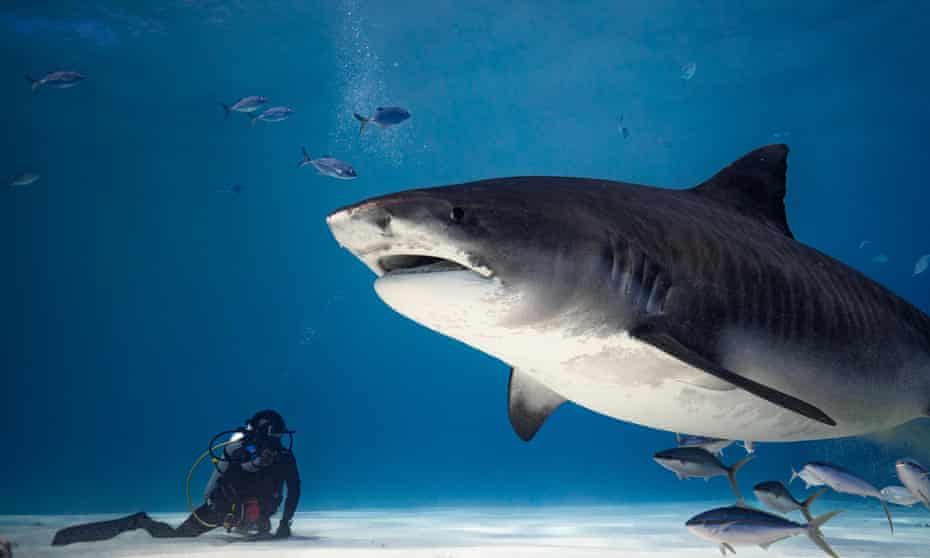
A tiger shark and scuba diver off Fuvahmulah in the Maldives. Scuba diving has boomed recently on the island as sharks came to be seen as an asset rather than a menace.
Photograph: Jono Allen
 
From The Guardian by Graeme Green
 
Diving with tiger sharks off Fuvahmulah brought a tourist boom that has led to a destructive tide of plastic waste.
But now locals are pushing back

“People used to think I was crazy,” says Lonu Ahmed. “Even my mum thought I was insane.
Fishermen used to beg me not to dive with sharks.”

Ahmed lives on the island of Fuvahmulah in the Maldives, an island surrounded by tiger sharks.
The islanders have traditionally been terrified of the creatures: fishermen would regularly kill them.
Ten years ago, however, believing the sharks were misunderstood, Ahmed jumped into the water, to the horror of onlookers. He says he saw something they didn’t.

“Everyday, fishermen in the market threw tuna scraps into the harbour,” he recalls. “I noticed the tiger sharks came to eat but never hunted the live fish, only the dead fish. I’ve never been afraid of sharks and knew the shark’s job was to clean the ocean. I wanted to be close to the sharks, to see them face to face.”
 
 
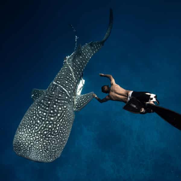
Lonu Ahmed, founder of the Fuvahmulah Marine Foundation, frees a whale shark that had become tightly entrapped by a length of plastic line.
Photograph: Jono Allen

Seeing Ahmed swim with the sharks, always returning unscathed, changed perceptions on the island.
“I told them not to worry, that sharks don’t attack humans,” he says.
“I love sharks. I feel relaxed and calm with sharks.
“Now fishermen know sharks aren’t dangerous. Today, a 12-year-old boy asked me if we can go freediving with the tiger sharks. The young generation especially love sharks. I tell the fishermen not to attack sharks because they keep the fish and tuna populations healthy,” Ahmed says.
“The fishermen are beginning to understand sharks aren’t dangerous.”

His initiative has led to a tourism boom on the island and, after previously doing laundry and housekeeping in resorts, he now takes tourists diving with sharks.
Scuba diving has transformed the economy, creating one of the biggest sources of income for local people.
In 2020, Unesco declared Fuvahmulah a biosphere reserve, though the island lacks an official conservation or protection organisation.

Diving has transformed the lives of the islanders, both commercially and in terms of their relationship to sharks. Until Ahmed took them out to dive with his company, Fuvamulah Tiger Shark Dive, many of them, such as Sand Saeed, were unable to swim.

“I’ve always had a huge fear,” Saeed says.
“But after Lonu took me to see the sharks face to face and see how they move and their behaviour,
 
 
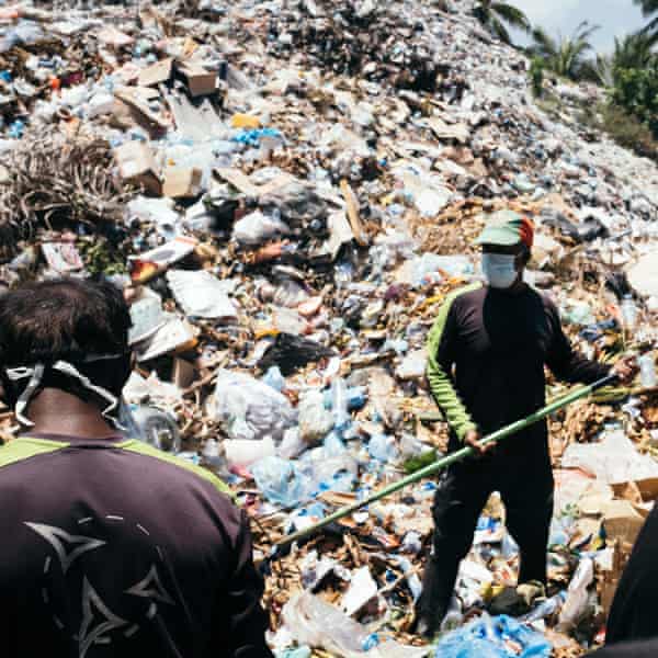
A mountain of rubbish, with vast amounts of plastic, has built up in Fuvahmulah with the tourist boom.
Photograph: Matt Porteous
 
“He’s had a good impact on the local community. People’s attitude towards sharks is changing.
This island used to fish sharks, but now most people value our sharks more alive than dead.
If Lonu hadn’t started diving here, many local people wouldn’t understand how beautiful the marine life and sharks here are.”

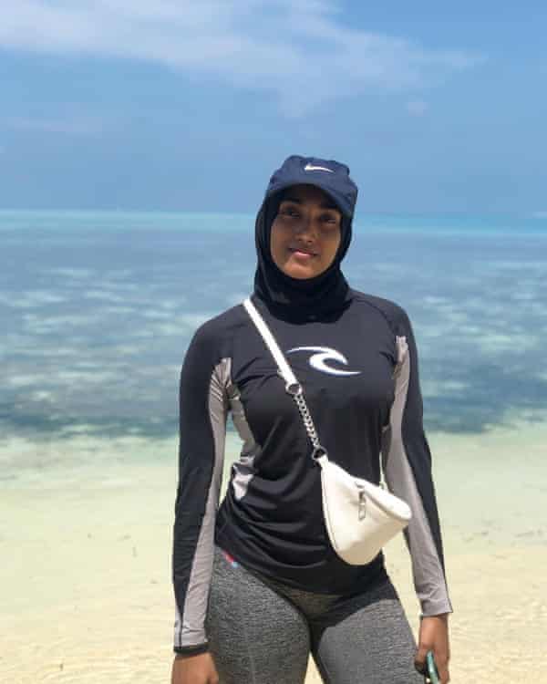
“When we were kids, sharks were something that infested the water,” says Hamna Hussain, a divemaster on Fuvahmulah. 
“My friends have real phobias but since diving with sharks, I’m never scared around them. It changed my life.
“If shark diving wasn’t discovered here, life now would be so different. I feel like this is a new era for this island. My goddaughter is two and every time she sees me she tells me she wants to see sharks. That’s a huge difference to when I was a kid.
“I’m the only local female divemaster here, and other locals, particularly men, see me and say: ‘If she can dive with sharks, so can I,’ which, although it’s kind of insulting, I see as a positive.”

But the new relationship with sharks has transformed the island in another, more lethal way.
As the island’s popularity grows, so does its inability to cope with the volume of plastic, brought in by tourists and locals.
 
 
‘If shark diving wasn’t discovered here, life now would be so different,’ says Hamna Hussain, a diving instructor on Fuvahmulah.
Photograph: Matt Porteous

The Maldives, isolated in the Indian Ocean, has one of the world’s highest population densities and little capacity to process plastic waste.
Plastic is now building up across beaches, streets, backroads, front yards and palm forests.
“This is the big issue in the Maldives,” says Ahmed.
“We have a big mountain of plastic on the island, and we don’t have recycling. Plastic bags, bottles, fishing lines … Everything is here and the mountain just keeps growing.”

Much of it is washing into the ocean, entangling marine life on the reef.
“I’ve seen many animals caught in plastic – manta rays, tiger sharks, silvertip sharks,” he says.
“The fish also eat the plastic and then local people eat this fish, so it’s very bad. The beach is [also] covered in plastic bottles and bags. People here just throw it on the ground.”

To mitigate the effects of the plastic waste, Ahmed and an underwater photographer, Jono Allen, with the support of the local council and mayor, set up a conservation organisation, Fuvahmulah Marine Foundation (FMF).
Its first goal is to work with the council to set up household waste separation scheme, sorting plastic, metals, paper, food and green waste so it can be processed on the island by hand. FMF is also trying to sort the current mountain of plastic on the island and reduce its size before it is transported to Malé, capital of the Maldives, for processing.
(There is now a recycling plant there set up by the environmental organisation Parley Maldives.)

There has been an island-wide introduction of reusable bags, water bottles, straws made from rice or paper, and cardboard food containers for locals and tourists.
Reducing the amount of imported plastic is seen as a key issue.
All the drinking water on the island comes in plastic bottles – more than 120,000 discarded plastic bottles every week.
So the foundation is encouraging tourists to bring their own reusable bottles and to stay at a hotel with a water filter, which reduces each tourist’s plastic footprint by an average of 21 bottles a week.
Reusable bags for shopping and containers for takeaway food would also help.

For Ahmed, protecting sharks and reducing plastic are part of the same battle.
“When I’m with the sharks, I feel like I’m in another world, like I’m in space or something.”
The plastic is a threat to that. 
“I want to see the importing of plastic stop, especially plastic bags and plastic bottles,” he says.
“I want to see a plastic-free future here in my lifetime.”

Links :

Thursday, November 25, 2021

New U-Boat Worx C-Researcher 3 aboard purpose-built feadship


Meet Shinkai, the world’s first superyacht designed around a submersible.
 

When the owner of the 54.9-meter explorer placed his order with Feadship, he already had a new U-Boat Worx C-Researcher 3 waiting to be accommodated.


With ocean exploration at the forefront of the owner’s mind, Shinkai – meaning ‘Deep Sea’ in Japanese – sets a new bar for bespoke, purpose-built, sub-orientated design.

 
Dutch submersible manufacturer U-Boat Worx is the largest private submarine supplier in the world. This C-Researcher 3 – winner of a Red Dot Product Design Award – can dive to depths of 480-meters to the heart of the Twilight Zone.
This largely undiscovered area is where around 90% of the world’s fish call home.

Drift along with deep sea cucumbers.
Feel enthralled at stunning bioluminescent light displays.
Capable of remaining submerged for up to 16 hours, the C-Researcher 3 provides a rare glimpse of squid, krill, jellies, and fish, all super-abundant in the mesopelagic zone.

As a long-time fan of U-Boat Worx, the owner knew exactly what he wanted; to be able to walk out of his master suite and step straight into his private three-seater sub.
To facilitate this, Shinkai’s aft deck sits flush with the submarine hatch for a neat and flawless finish. For further convenience, the C-Researcher 3 is the world’s first submersible fitted with an elevator to lower passengers into their seats.
 

A short recap of SHINKAI's transport and the first time on the open sea.
 
All U-Boat Worx subs have a single lifting point, which allows for safe and quick launch and recovery. Aboard Shinkai, this is further enhanced with a man-riding crane installed on the yacht’s aft deck.
With an almost 8-meter reach, the heavy-duty crane can deploy and retrieve the 6.9 - ton submarine with ease.

Simple, efficient and built to the owner’s specified short delivery time, the ruby red C-Researcher 3 with grey leather interior will transport the owner to a whole new world of underwater exploration.
And with man-riding certification on this U-Boat Worx sub, the owner can enjoy a front seat view from inside the sub’s air-conditioned, acrylic hull as its carefully lowered into open water.
 

The C-Researcher series offers scientists, researchers, documentary makers and explorers the most outstanding submersibles ever built.
Apart from the fact that these versatile submarines are ideally suited for research, their view, efficiency and speed make them also perfect for those who simply wish take in the views of the deep sea.
The eight different submarines in the C-Researcher series let private explorers and researchers pick the most suitable submersible for their mission objectives.
Available in various depth ratings up to 3,000 meters.
Please visit www.uboatworx.com for more information.
 
Complemented by Shinkai’s self-sufficiency, large nautical range and Ice-Class hull, the owner’s dreams of thrilling aquanaut adventures in the famous Northwest and Northeast Passages, as well as other far-flung destinations, are seamlessly brought to life in the U-Boat Worx C-Researcher 3.
 

Wednesday, November 24, 2021

Who controls the Arctic?


Russia is flexing its muscles as climate change opens up new possibilities in the north
 
THE ARCTIC CIRCLE stretches roughly 9,900 miles (16,000km) around the Earth.
It is the line north of which there is at least one day each year of total darkness and one of total light. Eight countries have territory within it: America (through Alaska), Canada, Denmark (by virtue of Greenland), Finland, Iceland, Norway, Russia and Sweden.
These eight make up the Arctic Council, a scientific-policy club, alongside 13 observer countries, including China, which calls itself a “near-Arctic state” and has plans for a “polar silk road” to make use of Arctic shipping routes and resource-extraction projects. Recently some of these states have jostled for control in the region.

Sergei Lavrov, Russia’s foreign minister, claimed last month that his country controls the Arctic.
“It has been absolutely clear for everyone for a long time that this is our territory,” he said.
Russian land makes up 53% of the Arctic coastline. Russia has also ramped up its military investment in the region: since 2007 at least 50 Soviet-era military outposts have reopened.
But the other Arctic states see things differently. In 2018 NATO sent an aircraft carrier into the Arctic Circle for the first time in 27 years.
Last year British and American warships entered the Barents Sea, north of Norway and close to Russia’s key naval bases, for the first time since the 1980s.
Next year Norway will carry out its biggest military exercise inside the Arctic Circle since the cold war. 


What explains this sabre-rattling, and who really controls the Arctic?

Most of the Arctic is ice or water.
Increasingly it is the latter: last year ice cover fell close to the lowest on record.
The minimum cover in 2020 was almost 1m square miles smaller than the average minimum between 1981 and 2010.
“Countries’ interest in this region came about because of climate change,” says Andreas Osthagen, of the Fridtjof Nansen Institute, near Oslo.
Melting ice has opened a shipping corridor from the Bering Strait, between Siberia and Alaska, to the Barents Sea.
The route remains frozen for up to nine months each year.
But in 2020 more than 1,000 cargo ships made the trip—25% more than the previous year.
Russia controls the route, which runs through its territorial waters, and charges a fee for passage.
But the opening up of the Northern Sea Route is a double-edged sword for Russia.
Ice was the bastion that protected its northern coast; its disappearance makes the country more vulnerable. Ahead of a summit in Brussels on June 14th, NATO said that melting ice “could lead to new geopolitical tensions.”

Arctic states are also competing to control the seabed: melting ice has made mineral deposits and oil- and gasfields more accessible.
To stake a claim beyond their territorial waters, which stretches 12 nautical miles from shore, countries must prove the seabed is an extension of their continental shelf—part of the same land mass as their territory.
The geology is subjective: Canada, Denmark and Russia all claim the Lomonosov Ridge, an underwater mountain range that runs beneath the North Pole.
Some countries have gone to extremes to prove their point. In 2007 a Russian submarine planted a titanium trikolor flag on the seabed beneath the pole. In 2013 Canada issued a passport to Father Christmas.
Such gestures might seem light-hearted, but alongside the increased military activity they constitute a real effort by governments to stake their claims.
For now, Russia has the uppermost hand. But as the ice shrinks, other countries’ interest in the Arctic will only grow.
 
Links :

Tuesday, November 23, 2021

Seabed features named after eminent American and Russian scientists

Agapova Seamount
 
Munk moment

From IHO
 
The work of two outstanding scientists has been recognized this year by the IHO-IOC GEBCO Sub-Committee of Undersea Feature Names (SCUFN) through the approval of the naming of two major undersea features.
  • the “Agapova Seamount” was proposed by the Geological Institute of the Russian Academy of Science (GINRAS);
  • the “Walter Munk Guyot” by the Scripps Institution of Oceanography at the University of California San Diego, USA.
“Their reputation transcends all borders and there is not a single oceanographer or geophysicist who ignores their work” Yves Guillam, IHO Assistant Director and Secretary of SCUFN

The name “Agapova Seamount” was given in memory of Galina Vladimirovna Agapova (1930-2018), marine geomorphologist and cartographer, who started working at the Russian Academy of Sciences in 1955.
She participated in many expeditions in the Black, Caspian, and Mediterranean Seas, as well as in the Pacific and Atlantic Oceans.
She contributed to the discovery of numerous seamounts, ridges and other features of the seafloor topography.
She was the author of more than 100 scientific papers and bathymetric, geological and tectonic maps, including the 5th edition of GEBCO, International Geological and Geophysical Atlases of the Indian, Atlantic and Pacific Oceans, the International Tectonic Map of the World etc.

 
Galina Vladimirovna Agapova participated in many expeditions and contributed to the discovery of numerous seamounts, ridges and other features of the seafloor.
In some places, the Agapova Seamount has inclines 30° steep.


G.V Agapova participated in the GEBCO Subcommittee on the nomenclature and terminology of the underwater relief forms (GEBCO-SCGN, now SCUFN) between1974 and 2007 and participated in the creation of the Guidelines on Standardization and the GEBCO Gazetteer.

The “Walter Munk Guyot” was named in memory of the legendary oceanographer/geophysicist whose body of work had profound implications for science and society as a whole.
Dr.
Munk’s contributions to science throughout the latter half of the 20th century and into the present century were measured not only in terms of the new knowledge his research yielded, but in the quality and diversity of the questions he considered.
His early research on waves for example, enabled him to work out a scheme to create reliable predictions, which was subsequently used during world War II to correctly predict that the waves troops would face taking the beach in Normandy would be high but manageable.
Research on the stability in water of bodies such as buoys is still used, for example in hydrodynamic analyses when evaluating the “Munk moment”.

More about Dr Munk here.

This guyot is located in the eastern Mid-Pacific Mountains.
Its deepest point is at 5200m and it is 3803m high.

 
The deepest point of the Walter Munk Guyot is at 5200m and it is 3803m high.


But what is a GUYOT ?
The official international definition says:
“A GUYOT is a SEAMOUNT with a comparatively smooth flat top”.
 
Examples of seamounts

Well… so what is a SEAMOUNT?
For the 12 Members of SCUFN (6 represent the IHO, and 6 the Intergovernmental Oceanographic Commission of UNESCO), who are responsible for developing and maintaining the Publication B-6, the standard and guidelines for Undersea Feature Naming: “A SEAMOUNT is a distinct generally equidimensional elevation greater than 1000m above the surrounding relief as measured from the deepest isobath that surrounds most of the feature.” 
 
Seafloor bathymetry (STRM) showing seamounts  in the GeoGarage platform

Recognized scientists in marine geosciences, hydrographers, oceanographers etc may have their name in the hall of fame of the GEBCO Gazetteer, however in accordance with a resolution of the United Nations Conference on the Standardization of Geographical Names, this can only be once they are deceased (as explained in B6).

The IHO-IOC GEBCO Gazetteer is the official international record of Undersea Feature Names across the globe.
It includes an interactive 3D map of the Earth to navigate and view undersea features, as well as Polar projections and 2D maps.
It records more than 4500 undersea features and allows visitors to search, view, and download information such as geographical location, feature type (seamount, ridge...) and dimensions, the person who discovered it, and the origin of the name.

Links :

Monday, November 22, 2021

Report: new data law cuts off access to Chinese AIS tracking

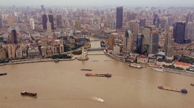
Inland traffic on Shanghai's Huangpu River (file image)

From Maritime Executive

Two new Chinese laws appear to be shutting down international access to ship AIS data picked up by shoreside stations in China, according to a new report.

According to Reuters, multiple Western users of AIS data have reported plummeting volumes of received signals - and it isn't because ships have turned off their AIS transcievers.
Instead, it appears that Chinese AIS data providers are responding to the restrictions in China's new Data Security Law (DSL) and Personal Information Protection Law (PIPL), which both took effect this fall.

These two laws restrict foreign access to any "important" data with bearing on Chinese national security or key infrastructure.
The fines for companies that fail to comply with the DSL are steep, up to $1.5 million, and PIPL's penalties are even larger.

The laws are new, and much will depend on how they are interpreted by China's regulators, but they appear to have created an immediate fall-off in the availability of Chinese terrestrial AIS receiver data for foreign users.
 
 MSA Maritime Safety Administration of the People's Republic of China AIS website :
 
One Chinese AIS data vendor confirmed to Reuters that it has stopped selling to foreign parties.

UK-based consultancy VesselsValue, which uses terrestrial AIS to track shipping patterns, told Reuters that it has seen a fall-off in AIS data availability of about 90 percent across all Chinese waters.
Two other sources said that the drop was smaller, about 45 percent, but still quite significant. 

Terrestrial AIS fills an important role in ship-tracking, according to Dana Goward, the former director of the U.S. Coast Guard's Maritime Domain Awareness Program.
 

Ships' AIS signals can be received by satellites, and this may fill in part of the gap left by China's new laws, but the loss of access to terrestrial AIS will mean a steep fall-off in tracking fidelity in Chinese littoral waters.
In China's busy harbors and waterways, hundreds of ships may be broadcasting in the same small area, and it can be hard for satellite receivers to pick those tightly-packed signals apart.

The change doesn't mean that ships have stopped broadcasting AIS, so it should have little impact on safety of navigation.
However, it will make it significantly harder for foreign observers to track ship movements in and around China - including movements potentially associated with illicit or clandestine activity.
"This is an unfortunate step backward for transparency in shipping," Goward said.