Saturday, January 14, 2023

British Isles & misc. (UKHO) layer update in the GeoGarage platform


with new world map (4000) including new ice extent
 
previous version of the Planisphere (in the GeoGarage platform 10 years ago)

 French voyages of discovery from the 15th through the 19th century

from Gallica BNF

This is a 1930 L. Bergelin pictorial map of the world celebrating French voyages of discovery from 1402 to 1840.
This map appeared at the end of the Années folles , a post-World War I period of rich social, artistic, and cultural innovation centered in Paris.
It coincided with a resurgence of French national pride, much of which was expressed in novel new forms of art that combined advances in printing, the rise of propaganda imagery, and egalitarian social values. 

 Links :

Friday, January 13, 2023

The extraordinary life of explorer Peter Freuchen

Peter Freuchen and his wife

From HistoryDefined y Miranda Leer

Easily one of the most interesting people that have walked the earth, the life of Peter Freuchen has gained so many public talks.
The life he lived suggests that of fulfillment and great exploits.

Peter Freuchen was an extraordinary explorer, writer, and anthropologist best known for his expeditions to Greenland and his work among the Inuit people.
He was born on February 2, 1886, in Denmark, and he would go on to lead a life full of adventure and accomplishment.

Away from his father’s blueprint


His father, Lorentz Freuchen, was a successful businessman who wanted a promising career and future for his son.
So he enrolled Peter at the University of Copenhagen to study medicine.

It wasn’t long until Peter realized his father’s idea of living a quiet and structured life was not for him.

As a kid, he had always been fascinated by sailing and traveling.
He would often bolt class to the sea to listen to stories of sailors who had made notable explorations.
So after a while in medical school, Peter Freuchen dropped out.

Carving his own path – the exciting career of Peter Freuchen

Freuchen began his career as an explorer in 1906 when he joined a Danish expedition to Greenland.
He and his companion Knud Rasmussen sailed as far north as they could from Denmark before abandoning their ship and going on foot for more than 600 kilometers.

They encountered and traded with the Inuit people while on their journey.
This trip sparked a lifelong fascination with the Arctic and its people.

Freuchen spent the next several decades exploring the region and studying the Inuit culture.
He learned to speak the Inuit language and lived among the native people for many years, learning their customs and ways of life.

In Cape York, Greenland, a trading post was established in 1910 by Peter Freuchen and Rasmussen, which they named Thule.

The Thule Expeditions, a series of seven expeditions, took place between 1912 and 1933, all departing from the Thule site.
In the period from 1910 to 1924, Freuchen traveled extensively in Greenland, visiting previously unexplored parts of the Arctic, and also gave lectures to tourists at Thule about Inuit culture.

One of Freuchen’s most famous expeditions took place in 1912 when he set out to cross Greenland from East to West.
The journey was difficult, and Freuchen and his team faced many challenges, including extreme cold, hunger, and treacherous ice conditions.

Yet, despite these obstacles, Freuchen persevered and completed the crossing, becoming the first person to do so on foot.

Beyond the expeditions – Freuchen’s literary works


In addition to his explorations, Freuchen also made significant contributions to the field of Anthropology.
He wrote several books about his experiences living among the Inuit, and his work helped to bring attention to the plight of indigenous people in the Arctic.

He was also a vocal advocate for their rights, working tirelessly to protect their way of life and ensure they were treated with respect and dignity.

His famous books include, among others:
  • “The Arctic Adventure of a Danish Explorer,” a book published in 1935, details Freuchen’s adventures in the Arctic and his encounters with the Inuit people.
  • “Peter Freuchen’s Book of the Seven Seas,” a book published in 1957, describes Freuchen’s travels to various locations worldwide, including the Arctic, Africa, and South America.
  • “The Vagrant Viking,” a book published in 1953, is a semi-autobiographical account of Freuchen’s life and experiences as an explorer and anthropologist.
  • “The Peter Freuchen Story,” a book published in 1956, is a collection of stories and essays about Freuchen’s life and adventures.

The Family life of a man busy exploring life


Freuchen had a complex and varied love life, with multiple marriages and relationships.

His first marriage was to a woman he met after he had started living amongst the Inuit people in Greenland.
Peter Freuchen wedded Mequpaluk, an Inuit woman, in 1911.

The couple had two kids: Mequsaq Avataq Igimaqssusuktoranguapaluk, a son, and Pipaluk Jette Tukuminguaq Kasaluk Palika Hager, a daughter.

Following Mequpaluk’s death from the Spanish Flu in 1921, Freuchen wedded Magdalene Vang Lauridsen in 1924.
Freuchen and Lauridsen’s marriage lasted 20 years before the pair split.

Freuchen married his third wife, Dagmar Cohn, a fashion illustrator and an immigrant from Denmark, in the United States in 1945.

Left with one leg – The famous feces chisel story

A terrible frostbite caused Freuchen to lose a leg in the 1920s.
He got stuck in the snow during a snowfall and had to use a chisel he made out of his frozen feces to free himself.

Even though the initial amputation only involved a few toes, Freuchen’s time as a daring explorer ended when another frostbite claimed the rest of the leg, then replaced with a wooden one.

Role in World war II and a significant player in the anti-Nazi scheme


Freuchen actively participated in the Danish resistance to the Nazis during World War II despite having a leg amputated.
He helped hide refugees on his island, but finally, the Germans found him and ordered his arrest and death sentence.
This forced him to escape to Sweden and then the US.

The last dance

A production company invited Freuchen to participate in a film project with other polar explorers at the North Pole in September 1957, when he was 71 years old.

Unfortunately, he suffered a heart attack and passed away while walking up the steps to the plane in Anchorage, Alaska.
His ashes were later scattered on the tundra near Thule, which held special significance for him.
 
 
Peter Freuchen with his wife Dagmar Cohn
 
The amazing life of Peter Freuchen

Despite the many hardships he faced, Freuchen remained an optimistic and determined individual.
He believed in the power of the human spirit and was always willing to take on new challenges and push himself to the limit.

This spirit of adventure and determination is what made Freuchen such an extraordinary figure, and it is what has inspired so many people throughout the world.

Peter Freuchen was an incredible explorer and anthropologist who dedicated his life to understanding and supporting the Inuit people of the Arctic.
His many expeditions and contributions to the field have made him a legend in the world of exploration, and his legacy will continue to inspire future generations of adventurers and anthropologists.
 
Links :

Thursday, January 12, 2023

NASA studies find previously unknown loss of Antarctic ice


The 200ft (60m) front of the Getz Ice Shelf in Antarctica is scored with cracks where icebergs are likely to break off, or calve, in this 2016 photo.
The first estimate of Antarctic calving has found that since 1997 ice shelves have lost as much ice from calving as from melting.
Credit: NASA/GSFC/OIB

From Meteorological Tech Int by Elizabeth Baker
 
New research from NASA on Antarctica – including the first map of iceberg calving – has found double the previous estimates of loss from ice shelves and details how the continent is changing.

The agency has stated that the greatest uncertainty in forecasting global sea level rise is how Antarctica’s ice loss will accelerate as the climate warms.
Two studies published August 10 and led by researchers at NASA’s Jet Propulsion Laboratory in Southern California reveal unexpected new data about how the Antarctic Ice Sheet has been losing mass in recent decades.

One study, published in the journal Nature, maps how iceberg calving – the breaking off ice from a glacier front – has changed the Antarctic coastline over the last 25 years.
The researchers found that the edge of the ice sheet has been shedding icebergs faster than the ice can be replaced.
This unexpected finding doubles previous estimates of ice loss from the Antarctic’s floating ice shelves since 1997, from six trillion to 12 trillion metric tons.
Ice loss from calving has weakened the ice shelves and enabled Antarctic glaciers to flow more rapidly to the ocean, accelerating the rate of global sea level rise.

The other study, published in Earth System Science Data, shows in unprecedented detail how the thinning of Antarctic ice as ocean water melts has spread from the continent’s outward edges into its interior, almost doubling in the western parts of the ice sheet over the past decade.
Combined, the complementary reports give the most complete view yet of how the frozen continent is changing.
 

Changes in elevation of the Antarctic ice sheet from 1985 to 2021 are shown.
Ice height diminishes (red) as the ice sheet melts by contact with ocean water; it rises (blue) where accumulation exceeds melting. Ice shelves are shown in gray.
The missions that supplied data are listed at bottom. Credit: NASA/JPL-Caltech
 
Chad Greene, JPL scientist and lead author of the calving study, said, “Antarctica is crumbling at its edges. And when ice shelves dwindle and weaken, the continent’s massive glaciers tend to speed up and increase the rate of global sea level rise.”

Most Antarctic glaciers flow to the ocean, where they end in floating ice shelves up to two miles (3km) thick and 500 miles (800km) across.
Ice shelves act like buttresses to glaciers, keeping the ice from simply sliding into the ocean.
When ice shelves are stable, they have a natural cycle of calving and replenishment that keeps their size fairly constant over the long term.

However, in recent decades, the warming ocean has been reportedly destabilizing Antarctica’s ice shelves by melting them from below, making them thinner and weaker.
Satellite altimeters measure the thinning process by recording the changing height of the ice, but NASA has pointed out that until this study, there hasn’t been a comprehensive assessment of how climate change might be affecting calving around the continent.
This is partly because satellite imagery has been challenging to interpret.

Greene continued, “For example, you can imagine looking at a satellite image and trying to figure out the difference between a white iceberg, white ice shelf, white sea ice, and even a white cloud.
That’s always been a difficult task.
But we now have enough data from multiple satellite sensors to see a clear picture of how Antarctica’s coastline has evolved in recent years.”

For the new study, Greene and his co-authors synthesized satellite imagery of the continent in visible, thermal infrared (heat), and radar wavelengths since 1997.
Combining these measurements with an understanding of ice flow gained from an ongoing NASA glacier-mapping project, they charted the edges of ice shelves around 30,000 linear miles (50,000km) of the Antarctic coastline.

Losses from calving have outpaced natural ice-shelf growth so greatly that the researchers think it’s unlikely Antarctica can grow back to its pre-2000 extent by the end of this century.
In fact, the findings suggest that greater losses can be expected: Antarctica’s largest ice shelves all appear to be headed for major calving events in the next 10 to 20 years.

In the complementary study, JPL scientists have combined almost three billion data points from seven spaceborne altimetry instruments to produce the longest continuous data set on the changing height of the ice sheet – an indicator of ice loss – from as early as 1985.
They used radar and laser measurements of ice elevation, accurate to within centimeters, to produce the highest-resolution monthly maps of change ever made of ice loss.

The unparalleled detail in the new record reveals how long-term trends and annual weather patterns affect the ice.
It even shows the rise and fall of the ice sheet as subglacial lakes regularly fill and empty miles below the surface.
JPL’s Johan Nilsson, the lead author of the study, said, “Subtle changes like these, in combination with an improved understanding of long-term trends from this data set, will help researchers understand the processes that influence ice loss, leading to improved future estimates of sea level rise.”

Synthesizing and analyzing the massive archives of measurements into a single, high-resolution data set took years of work and thousands of hours of computing time on NASA’s servers.
Nilsson said, “Condensing the data into something more widely useful may bring us closer to the big breakthroughs we need to better understand our planet and to help prepare us for the future impacts of climate change.”
 
Links :

Wednesday, January 11, 2023

Global Fishing Watch: Raising awareness of the impacts of overfishing


 From Earth.org by Pamela Ferrris-Olson
 
As 8% of humans depend on the world’s oceans to supply their food, detailed information is needed to adequately maintain a sustainable worldwide fishery.
Non-profits like Global Fishing Watch and The Outlaw Ocean Project are helping raise awareness of the impacts of overfishing and overcome the challenges of data collection from the vast marine realm to provide reliable information on how and where the world’s oceans and fish stocks are being used and misused.

The world’s oceans are a vast realm, on a scale that makes it far too time-consuming, too costly, and too dangerous for any single entity to manage.
The result is that the high seas are poorly understood and under-protected.
Detailed information about the scope and whereabouts of fishing is often lacking.
Even a determination of what entity has the jurisdiction for enforcement is difficult to determine.

The Work of The Outlaw Ocean Project and Global Fishing Watch

The Outlaw Ocean Project is a non-profit journalism organisation based in Washington D.C.
that produces the Outlaw Ocean podcast, a riveting, first-hand account of the problem.
The seven-part series relies on more than eight years of reporting covering all seven oceans and more than three dozen countries.
The Dark Fleet, the second episode, tells the story of a search for one of the most wanted illegal fishing vessels.
The pursuit lasting 110 days, across 10,000 nautical miles documented the vessel’s illegal activities catching Chilean sea bass in the waters off Antarctica.
Not only was fishing occurring in waters not open to commercial fishing, but it also involved gillnets, a banned type of fishing gear.
One net over 45 miles in length took over 100 hours to haul in.
The story, rather than being an unusual occurrence, is one that is simply rarely documented due in part to the lack of data on fishing fleets that sail the high seas.

Global Fishing Watch (GFW) has been working to make such occurrences transparent so stakeholders can assess the extent to which the world’s oceans are being used and misused.
GFW is an open-access satellite and machine learning technology that provides map visualisations and data and analysis tools to better visualise the threats that the world’s oceans face nowadays.
The data identifies hotspots of previously heretofore unseen fishing vessels, making it possible to determine where and how much fishing activity is actually occurring.


Tracking Illegal Fishing In North Korea Waters

Jaeyoon Park (GFW) with colleagues reported in a 2020 Science Advances article that illegal, unreported, and unregulated fishing is a major challenge to assess because “most fishing vessels do not broadcast their positions and are ‘dark’ in public monitoring systems.”

These challenges are epitomised in the waters of North Korea, South Korea, Japan, and Russia where stocks of Japanese flying squid (Todarodes pacificus) are heavily targeted.
A lack of information about the fishery “prevents accurate stock assessment in a fishery where reported catches have dropped by 80% and 82% in South Korean and Japanese waters, respectively, since 2003.” This is troubling because squids are of critical importance to South Korea.
Here, they are ranked top seafood by production value.
In Japan, squid is among the top five seafood consumed and in North Korea, it was the third-largest exported product before sanctions were imposed.

The research utilised four satellite technologies to assess fishing operations.
Each of the technologies has limitations but, when used in combination, they provide sufficient data to present an informative picture of the scope of fishing activity.
One of these technologies is the Automatic Identification System (AIS), originally developed to reduce vessel collisions.
AIS equipment provides a unique identification for each vessel as well as information about its position, course, and speed.
It is possible to turn off a vessel’s AIS.
This allows the ship to operate undetected but, of course, leaves the vessel and its crew at risk of collision.

Visible Infrared Imaging Radiometer Suite (VIIRS) is another satellite technology that exploits the bright lights used to attract the flying squid.
Vessels measuring between 55 and 60 metres are equipped with lights that can emit light equivalent to a football stadium.
VIIRS’s utility is reduced by cloud cover.
Used in combination with satellite technologies, they can help “identify potential hot spots of illegal, unregulated, or unreported fishing.”

“Global fisheries have long been dominated by a culture of confidentiality and concealment and achieving a comprehensive view of fishing activities at sea is an important step toward sustainable and cooperative fisheries management,” the paper reads.

Industrial Fishmeal Production In African Waters

The biggest culprit in declining fish stocks is overfishing.
Episode 5 of The Outlaw Ocean podcast focuses on the African West Coast nation of Gambia and its fishmeal factories.
The three fishmeal factories in Gambia process local fish like Bonga into high-protein powder or pellets.
The fishmeal is shipped abroad and used to feed animals like livestock and farmed-raised fish.
An astonishing fact mentioned in the podcast is that “more than a quarter of all the fish pulled from the sea ends up as fishmeal.”

In Gambia, Bonga used to be plentiful, so much so that it was widely available for free in local markets.
The sharp decline in Bonga, however, has left communities without their daily source of protein.

Farm-raised fish were once thought to be a solution to the world’s need for protein.
The thought was that by farming fish there would be an equivalent reduction in pressure to harvest fish from the sea.
However, there has been a growing realisation that farm-raised fish generate their own problems.
Among them is pollution, a consequence of concentrating large numbers of fish – up to 200,000 – in a single pen.

Arguably the most troubling problem in raising fish is that more food energy is used than is produced.
Ian Urbina, American investigative reporter and founder of The Outlaw Ocean Projectobserved that some fish farms take in more fish in the form of fishmeal than they actually produce.
In the case of tuna, for example, “you can have a single tuna that will eat 15 times its own weight in fishmeal before it’s to the size that it needs to be put on the market,” he explains.
“So even conscientious consumers who are trying to be ethical buyers are quite likely eating fish that are taking food off of the tables of Gambians or others in the developing world.”

The economic reality is that fish-based feed is expensive.

“40% of the cost of raising a farmed fish is the feed,” writes Mark Kurlansky in The Guardian.
“Farming companies would like to reduce that by turning their salmon into vegetarians, but this is not easy because salmon have short intestines designed for digesting meat but not well-suited for plants.”
Why Is the Work of NGOs So Important?

The work of organisations like Global Fishing Watch and The Outlaw Ocean Project contributes knowledge useful in understanding the kind and extent of illegal fishing and overfishing.
Their work is an important contribution toward making informed choices for local, national, and international management of fish stocks and fishing fleets.
However, countless problems remain, and they are inherent in the management of a global marine commons.
Questions such as how or whether to manage fisheries and who might be utilising a resource at the expense of others are far more challenging to overcome.
 
Links :

Tuesday, January 10, 2023

More than 100,000 tourists will head to Antarctica this summer. Should we worry about damage to the ice and its ecosystems?


From The Conversation by Elisabteh Lean / Anne Hardy / Can Seng Ooi / Carlyn Philpott / Hanne E.F.
Nielsen & Katie Marx


As the summer sun finally arrives for people in the Southern Hemisphere, more than 100,000 tourists will head for the ice.
Travelling on one of more than 50 cruise ships, they will brave the two-day trip across the notoriously rough Drake Passage below Patagonia, destined for the polar continent of Antarctica.

During the COVID summer of 2020-21, just 15 tourists on two yachts visited Antarctica.
But now, tourism is back – and bigger than ever.
This season’s visitor numbers are up more than 40% over the largest pre-pandemic year.

So are all those tourists going to damage what is often considered the last untouched wilderness on the planet? Yes and no.
The industry is well run.
Tourists often return with a new appreciation for wild places.
They spend a surprisingly short amount of time actually on the continent or its islands.

But as tourism grows, so will environmental impacts such as black carbon from cruise ship funnels.
Tourists can carry in microbes, seed and other invasive species on their boots and clothes – a problem that will only worsen as ice melt creates new patches of bare earth.
And cruise ships are hardly emissions misers.


As tourist numbers have grown, operators have moved to offer activities like kayaking.
Shutterstock

How did Antarctic tourism go mainstream?

In the 1950s, the first tourists hitched rides on Chilean and Argentinian naval vessels heading south to resupply research bases on the South Shetland Islands.
From the late 1960s, dedicated icebreaker expedition ships were venturing even further south.
In the early 1990s, as ex-Soviet icebreakers became available, the industry began to expand – about a dozen companies offered trips at that time.
By the turn of this century, the ice continent was receiving more than 10,000 annual visitors: Antarctic tourism had gone mainstream.

What does it look like today?

Most Antarctic tourists travel on small “expedition-style” vessels, usually heading for the relatively accessible Antarctic Peninsula.
Once there, they can take a zodiac boat ride for a closer look at wildlife and icebergs or shore excursions to visit penguin or seal colonies.
Visitors can kayak, paddle-board and take the polar plunge – a necessarily brief dip into subzero waters.

For most tourists, accommodation, food and other services are provided aboard ship.
Over a third of all visitors never stand on the continent.

Those who do set foot on Antarctica normally make brief visits, rather than taking overnight stays.

For more intrepid tourists, a few operators offer overland journeys into the continent’s interior, making use of temporary seasonal camp sites.
There are no permanent hotels, and Antarctic Treaty nations recently adopted a resolutionagainst permanent tourist facilities.

As tourists come in increasing numbers, some operators have moved to offer ever more adventurous options such as mountaineering, heli-skiing, underwater trips in submersibles and scuba diving.


Summer is the only time tourists can safely visit Antarctica.
Shuttersock

Is Antarctic tourism sustainable?


As Antarctic tourism booms, some advocacy organisations have warned the impact may be unsustainable.
For instance, the Antarctic and Southern Ocean Coalition argues cruise tourism could put increased pressure on an environment already under significant strain from climate change.

In areas visited most by tourists, the snow has a higher concentration of black carbon from ship exhaust, which soaks up more heat and leads to snow melt.
Ship traffic also risks carrying hitchhiking invasive species into the Southern Ocean’s vulnerable marine ecosystems.

That’s to say nothing of greenhouse gas emissions.
Because of the continent’s remoteness, tourists visiting Antarctica have a higher per capita carbon footprint than other cruise-ship travellers.

Of course, these impacts aren’t limited to tourism.
Scientific expeditions come with similar environmental costs – and while there are far fewer of them, scientists and support personnel spend far more time on the continent.

Antarctic tourism isn’t going away – so we have to plan for the future

Are sustainable cruises an oxymoron? 
 
Many believe so.

Through its sheer size, the cruise industry has created mass tourism in new places and overtourism in others, generating unacceptable levels of crowding, disrupting the lives of residents, repurposing local cultures for “exotic” performances, damaging the environment and adding to emissions from fossil fuels.

In Antarctica, crowding, environmental impact and emissions are the most pressing issues.
While 100,000 tourists a year is tiny by global tourism standards – Paris had almost 20 million in 2019 – visits are concentrated in highly sensitive ecological areas for only a few months per year.
There are no residents to disturb (other than local wildlife), but by the same token, there’s no host community to protest if visitor numbers get too high.

Even so, strong protections are in place.
In accordance with the Antarctic Treaty System – the set of international agreements signed by countries with an Antarctic presence or an interest – tourism operators based in those nations have to apply for permits and follow stringent environmental regulations.

To avoid introducing new species, tourists have to follow rules such as disinfecting their boots and vacuuming their pockets before setting foot on the ice, and keeping a set distance from wildlife.

Almost all Antarctic cruise owners belong to the International Association of Antarctica Tour Operators, the peak body that manages Antarctic tourism.

For the first time this year, operators have to report their overall fuel consumption as part of IAATO’s efforts to make the industry more climate-friendly.
Some operators are now using hybrid vessels that can run partly on electric propulsion for short periods, reducing carbon dioxide emissions. 
 

Cruise ships make mass tourism possible - but they come with environmental costs. 
Shutterstock
Returning from the ice: the ambassador effect


Famed travel writer Pico Iyer recently wrote of his experience in the deep south of the world.
The visit, he said, “awakens you to the environmental concerns of the world … you go home with important questions for your conscience as well as radiant memories”.

Iyer isn’t alone.
This response is widespread, known in the industry as Antarctic ambassadorship.
As you’d expect, this is strongly promoted by tourism operators as a positive.

Is it real? That’s contentious.
Studies on links between polar travel and pro-environmental behaviour have yielded mixed results.
We are working with two operators to examine the Antarctic tourist experience and consider what factors might feed into a long-lasting ambassador effect.

If you’re one of the tourists going to Antarctica this summer, enjoy the experience – but go with care.
Be aware that no trip south comes without environmental cost and use this knowledge to make clear-eyed decisions about your activities both in Antarctica and once you’re safely back home.
 
Links :

Monday, January 9, 2023

The strange story of Sealand, the smallest country in the world


From History Defined by Carl Seaver

Sealand is a tiny country located in the North Sea, about 12 miles off the coast of England.
It is considered the smallest country in the world, which once had a population of 50 people.

Sealand was created in 1967 by Paddy Roy Bates, who declared it an independent nation after he and his family occupied a disused Navy fort near the HM Fort Roughs.

The story of Sealand is fascinating, and it has been home to some exciting events over the years.Sealand
What is it, And Where is it Located?

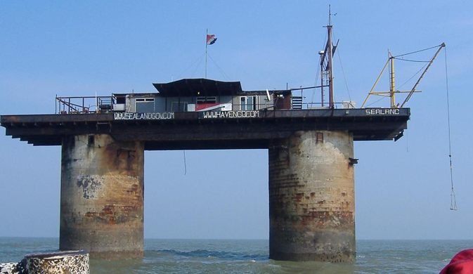
Sealand is a strange place.
It’s the smallest country in the world and on a platform in the North Sea that was once used as a military fort.

In 1967, Paddy Roy Bates, a retired British army major, declared himself ruler of the country, and his family has been running it ever since

Sealand has had its share of controversy over the years, and it remains an oddity to this day.

It started as an idea that became a gift to his wife Joan for her birthday.
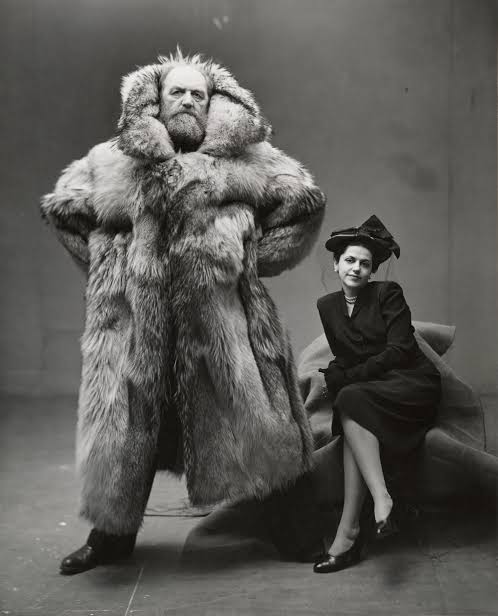
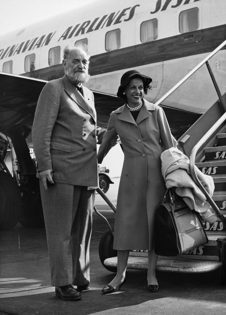
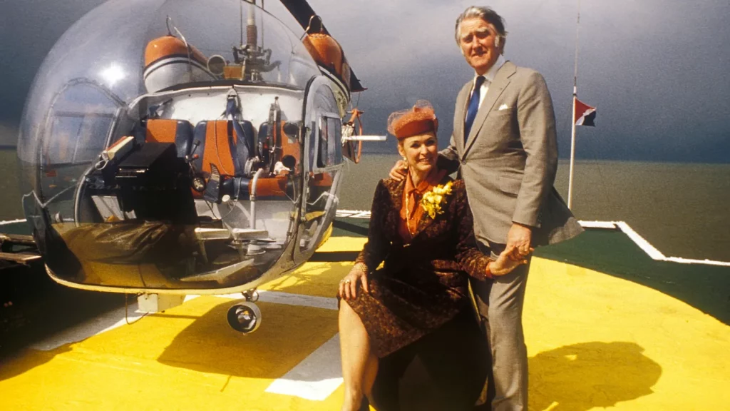
 
 
Roy and Joan Bates. 
Credit: Martyn Goddard/Alamy

On Christmas Eve in 1966, Bates took a boat and drove it to the platform.
Then, using a grappling hook, rope, and his wit, he climbed to the top of the platforms and claimed them, conquering them for his wife as a gift.

The gift itself was odd and was nothing fancy to look at; in the past, it had a much different purpose.
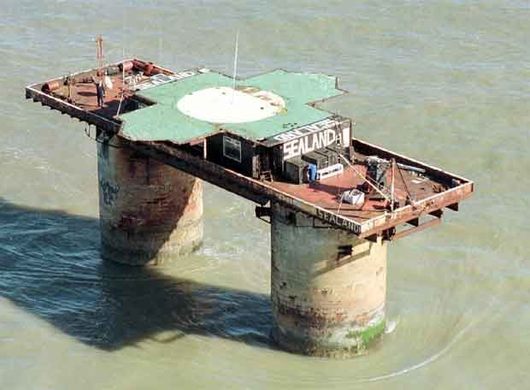
In the early 1940s, around WWII, the His Majesty’s Ford (HMF) Roughs Tower was an outpost and one of five to defend the Thames.

It was about the size of two tennis courts set on top of two hollow concrete towers approximately 60 feet above the ocean.

In its heyday, the platform was manned was over a hundred British military men armed to the teeth with anti-aircraft guns.
These guns stood between the Nazi bombers and London during the Blitz.

The fort was abandoned in the late 1950s, well after the German’s defeat, and by the time Roy came to claim it, the UK had long since forgotten it.
However, that didn’t stop British Authorities from ordering him to abandon it.

Despite their warnings, Roy Bates was a hardened man who had served since he was 15, first in the Spanish Civil War and then in North Africa, the Middle East, and Italy during WWII.

So, Roy Bates wasn’t scared of bureaucrats trying to tell him what to do.
Instead, he ignored their warnings and continued what he was doing, and Sealand’s reputation grew as a result.

The Sovereignty of a Micro-nation

The story starts with Roy Bates establishing a pirate radio station on the platform in 1965.
At the time, it was illegal, but Bates saw an opportunity.

He first started his radio station at an old WWII fort called Knock John, another one of the forts used to repel the German assault, now decommissioned.

In all honesty, Bates started this pirate radio station because, like many others, he did not enjoy the BBC’s monopoly on the airwaves.

At the time, the British Broadcasting Corporation (BBC) was the only legal radio station, and they had complete control of what people could and couldn’t listen to because of a Royal Charter.

Bates started his pirate radio station because he saw this as an opportunity to give people the music they wanted to hear, not just what the Post Office or the government wanted them to hear.

However, the British authorities made it impossible for Bates and other pirate radio stations to broadcast, so the retired navy officer gave it up.
At the time, leaders may have thought that Bates would give up Fort Roughs, but he doubled down.

It’s said that after a night with friends and comments from his wife, Bates named the fort the “Principality of Sealand” on September 2, 1967.
It was his wife’s birthday, and not long after, his family moved with him to the smallest country in the world.

The establishment of this unrecognized sovereignty in British waters, just seven miles off the coast of Suffolk, quickly caught the attention of the UK government.

The British authorities were unhappy with this turn of events, describing Sealand as “an illegal occupation of a structure not recognized as an island under international law.”

On the other hand, Bates was adamant that Sealand was its own country and that he was its rightful leader.
Authorities saw this as a version of Cuba and were determined to stop it.

So in 1968, the military sent helicopters to destroy the remaining outposts to keep any more principalities from popping up.
Again, Roy and his family saw a potential threat to their livelihood. 
 
Sealand

Then, when UK officials were working on a buoy near the principality, Michael, Roy’s son, fired a .22 pistol at them.

In response, the British government brought charges against Michael for discharging and illegal possession, but the court didn’t rule as expected.
Since the actions happened outside British jurisdiction, they were unpunishable by the law.

Sealand believed this to be recognition of their country, so they declared independence.

German Usurpers

In 1978, a West German businessman named Alexander Gottfried Achenbach declared himself the “Prime Minister” of Sealand and staged a coup.

Bates had left Sealand to deal with a family emergency, and during his absence, Achenbach and some German and Dutch mercenaries took over the platform.

They held Prince Michael hostage and locked him away for four days.
Bates quickly assembled a team to retake the platform without incident.

Many of Achenbach’s group fled during the operation, but Bates decided to hold Achenbach hostage.
When a UK ambassador negotiated with Bates, he finally released Achenbach.

UK Expanse


In the 1980s, the British government expanded its territorial waters to remove any legitimacy to Sealand’s claims.
Nevertheless, Bates continued to assert that Sealand was an independent country.

His response was to issue Sealand’s currency, passports, and stamps.
The country even had a flag and a motto E Mare, Libertas, which means “From the sea, freedom.”

Despite Some Issues, Sealand is Still Out There Today

Unfortunately, in the 1990s, Sealand had to rescind its passports after people used some for criminal activity.

In 2006 a destructive fire broke out on the platform and destroyed the main power generator, prompting a brief sale period of the platform in 2007.
However, the citizens devised a solution and fixed the issues.

Sealand is still out there today, and Michael Bates and his family remain involved in Sealand’s well-being and operate it as an independent country.
They’ve even established full-time security on the platform.

The principality even has its website and sells souvenirs, like coins, patches, and T-shirts, to help with costs.
Incredibly, such a small structure in the middle of the sea has maintained its sovereignty for over 50 years.

Sealand has had a mercenary invasion and constant threats from the UK government, but they stood firm.

Though any other country does not officially recognize it, Sealand is the smallest country in the world and has an exciting history.

What started as a World War II fort became a family project and an independent nation.
Despite its rocky past, Sealand continues and is recognized, even if it’s unofficially, as the smallest country worldwide.
 
Links :

Sunday, January 8, 2023

Tarmo icebreaker arriving Helsinki (1907)

This icebreaker was launched on 9 September 1907 and given the name Tarmo, meaning "vigor" and "spirit" in the Finnish language.
The ship was delivered on 17 December 1907 and on 30 December she left Newcastle under the command of Captain Leonard MelĂ¡n and headed down the River Tyne to Hanko, Finland, where she arrived on 3 January 1908.
Flawlessly served for 64 years until her retirement in 1970, being now a museum ship. 
Opening shots from Peter von Bagh's 2008 documentary "Helsinki, ikuisesti" ("Helsinki Forever") show a crowd admiring (and soon being chased by) the icebreaker Tarmo in Helsinki, Finland.
Apparently filmed in the 1920s.