Saturday, September 9, 2023

Earthquakes of the 20th Century

 8.8 — Ecuador — 31 January 1906
8.4 — Kamchatka, Russia — 3 February 1923
8.4 — Sanriku, Japan — 2 March 1933
8.6 — Unimak Island, Aleutian Islands — 1 April 1946
9.0 — Kamchatka, Russia — 4 November 1952
8.6 — Andreanof Islands, Aleutian Islands — 9 March 1957
9.5 — Valdivia, Chile — 22 May 1960
9.2 — Prince William Sound, Alaska — 28 March 1964
8.7 — Rat Islands, Aleutian Islands — 4 February 1965
 
From NOAA

This animation shows every recorded earthquake in sequence as they occurred from January 1, 1901, through December 31, 2000, at a rate of 1 year per second.
The earthquake hypocenters first appear as flashes then remain as colored circles before shrinking with time so as not to obscure subsequent earthquakes.
The size of the circle represents the earthquake magnitude while the color represents its depth within the earth.
At the end of the animation it will first show all quakes in this 100-year period.
Next, it will show only those earthquakes greater than magnitude 6.5, the smallest earthquake size known to make a tsunami.
It will then show only those earthquakes with magnitudes of 8.0 or larger, the "great" earthquakes most likely to pose a tsunami threat when they occur under the ocean or near a coastline and when they are shallow within the earth (less than 100 km or 60 mi.
deep).
The animation concludes by showing the plate boundary faults responsible for the majority of all of these earthquakes.

This other animated map makes use of USGS data to map earthquake events with a magnitude of 6.0 and greater from 1900 to November 2019.
The depths of the earthquakes have been exaggerated so we can actually see the relative depths of these events.
This map also highlights several key earthquakes in the last 120 years, including the 1906 San Francisco (M7.9) earthquake, the Great Chilean Earthquake (M9.5) of 1960, and the more recent event that rocked Haiti (M7.1) in 2010.
source ESRI

The era of modern earthquake seismology—the scientific study of earthquakes—began in the 20th Century with the invention of the seismometer and its deployment in instrument networks to record and measure earthquakes as they occur.
Therefore, when the animation begins only the largest earthquakes appear as they were the only ones that could be detected at great distances with the few available instruments available at the time.
But as time progresses, more and more seismometers were deployed and smaller and smaller earthquakes could be recorded.
For example, note how in the 1930’s many small earthquakes suddenly seem to appear in California, but this illusion results from the installation of more and more instruments in that region.
Likewise, there appears to be a jump in the number of earthquakes globally in the 1970's when seismology took another leap forward with advances in telecommunications and signal processing with digital computers, a trend that continues today.

20th Century seismology revealed the global geographic distribution of earthquakes and helped to solidify the Theory of Plate Tectonics.
Notice how earthquake epicenters do not occur randomly in space but form patterns over the earth’s surface, revealing the boundaries between tectonic plates as shown toward the end of this animation.
This time period also includes some remarkable events, including those that generated devastating tsunamis:

These earthquakes represent some of the largest ever recorded.
Note how they all occur at a particular type of plate boundary, subduction zones where tectonic plates collide, so these are the regions where we expect future devastating tsunamis to be generated.


Friday, September 8, 2023

The snow crab vanishes


More than ten billion snow crabs disappeared from the Bering Sea between the years 2018 and 2022, devastating a commercial fishing industry worth $200 million.
Now, fishermen and researchers are teaming up in Kodiak, Alaska to figure out what happened, and they think warmer ocean water could be to blame.
 
From Wired by Julia O'Malley   

Over the past few years, billions of snow crabs have unexpectedly disappeared from the Bering Sea.
What happens to the Indigenous people who depend on them for survival?


My small turboprop plane whirred low through thick clouds.
Below me, St. Paul Island cut a golden, angular shape in the shadow-dark Bering Sea.
I saw a lone island village—a grid of houses, a small harbor, and a road that followed a black ribbon of coast.

Saint Paul island in the GeoGarage platform (NOAA nautical raster chart)

Some 330 people, most of them Indigenous, live in the village of St. Paul, about 800 miles west of Anchorage, where the local economy depends almost entirely on the commercial snow crab business.
Over the past few years, 10 billion snow crabs have unexpectedly vanished from the Bering Sea.
I was traveling there to find out what the villagers might do next.

The arc of St. Paul’s recent story has become a familiar one—so familiar, in fact, that I couldn’t blame you if you missed it.
Alaska news is full of climate elegies now—every one linked to wrenching changes caused by burning fossil fuels.
I grew up in Alaska, as my parents did before me, and I’ve been writing about the state’s culture for more than 20 years.
Some Alaskans’ connections go far deeper than mine.
Alaska Native people have inhabited this place for more than 10,000 years.

As I’ve reported in Indigenous communities, people remind me that my sense of history is short and that the natural world moves in cycles.
People in Alaska have always had to adapt.

Even so, in the past few years I’ve seen disruptions to economies and food systems, as well as fires, floods, landslides, storms, coastal erosion, and changes to river ice—all escalating at a pace that’s hard to process.
Increasingly, my stories veer from science and economics into the fundamental ability of Alaskans to keep living in rural places.

You can’t separate how people understand themselves in Alaska from the landscape and animals.
The idea of abandoning long-occupied places echoes deep into identity and history.
I’m convinced the questions Alaskans are grappling with—whether to stay in a place and what to hold onto if they can’t—will eventually face everyone.

I’ve given thought to solastalgia—the longing and grief experienced by people whose feeling of home is disrupted by negative changes in the environment.
But the concept doesn’t quite capture what it feels like to live here now.

A few years ago, I was a public radio editor on a story out of the small Southeast Alaska town of Haines about a storm that came through carrying a record amount of rain.
The morning started routinely—a reporter on the ground calling around, surveying the damage.
But then, a hillside rumbled down, taking out a house and killing the people inside.
I still think of it—people going through regular routines in a place that feels like home, but that, at any time, might come cratering down.
There’s a prickly anxiety humming beneath Alaska life now, like a wildfire that travels for miles in the loamy surface of soft ground before erupting without notice into flames.

But in St. Paul, there was no wildfire—only fat raindrops on my windshield as I loaded into a truck at the airport.
In my notebook, tucked into my backpack, I’d written a single question: “What does this place preserve?”

THE SANDY ROAD from the airport in late March led across wide, empty grassland, bleached sepia by the winter season.
Town appeared beyond a rise, framed by towers of rusty crab pots.
It stretched across a saddle of land, with rows of brightly painted houses—magentas, yellows, teals—stacked on either hillside.
The grocery store, school, and clinic sat in between them, with a 100-year-old Russian Orthodox church named for Saints Peter and Paul, patrons of the day in June 1786 when Russian explorer Gavril Pribylov landed on the island.
A darkened processing plant, the largest in the world for snow crabs, rose above the quiet harbor.

You’re probably familiar with sweet, briny snow crab—Chionoecetes opilio—which is commonly found on the menus of chain restaurants like Red Lobster.
A plate of crimson legs with drawn butter there will cost you $32.99.
In a regular year, a good portion of the snow crab America eats comes from the plant, owned by the multibillion-dollar company Trident Seafoods.

Not that long ago, at the peak of crab season in late winter, temporary workers at the plant would double the population of the town, butchering, cooking, freezing, and boxing 100,000 pounds of snow crab per day, along with processing halibut from a small fleet of local fishers.
Boats full of crab rode into the harbor at all hours, sometimes motoring through swells so perilous they’ve become the subject of a popular collection of YouTube videos.
People filled the town’s lone tavern in the evenings, and the plant cafeteria, the only restaurant in town, opened to locals.
In a normal year, taxes on crab and local investments in crab fishing could bring St. Paul more than $2 million.

Then came the massive, unexpected drop in the crab population—a crash scientists linked to record-warm ocean temperatures and less ice formation, both associated with climate change.
In 2021, federal authorities severely limited the allowable catch.
In 2022, they closed the fishery for the first time in 50 years.
Industry losses in the Bering Sea crab fishery climbed into the hundreds of millions of dollars.
St. Paul lost almost 60 percent of its tax revenue overnight.
Leaders declared a “cultural, social, and economic emergency.” Town officials had reserves to keep the community’s most basic functions running, but they had to start an online fundraiser to pay for emergency medical services.

Through the windshield of the truck I was riding in, I could see the only cemetery on the hillside, with weathered rows of Orthodox crosses.
Van Halen played on the only radio station.
I kept thinking about the meaning of a cultural emergency.

Some of Alaska’s Indigenous villages have been occupied for thousands of years, but modern rural life can be hard to sustain because of the high costs of groceries and fuel shipped from outside, limited housing, and scarce jobs.
St. Paul’s population was already shrinking ahead of the crab crash.
Young people departed for educational and job opportunities.
Older people left to be closer to medical care.
St. George, its sister island, lost its school years ago and now has about 40 residents.

If you layer climate-related disruptions—such as changing weather patterns, rising sea levels, and shrinking populations of fish and game—on top of economic troubles, it just increases the pressure to migrate.

When people leave, precious intangibles vanish as well: a language spoken for 10,000 years, the taste for seal oil, the method for weaving yellow grass into a tiny basket, words to hymns sung in Unangam Tunuu, and maybe most importantly, the collective memory of all that had happened before.
St.
Paul played a pivotal role in Alaska’s history.
It’s also the site of several dark chapters in America’s treatment of Indigenous populations.
But as people and their memories disappear, what remains?

There is so much to remember.

THE PRIBILOFS CONSIST of five volcano-made islands—but people now live mainly on St.
Paul.
The island is rolling, treeless, with black sand beaches and towering basaltic cliffs that drop into a crashing sea.
In the summer it grows verdant with mosses, ferns, grasses, dense shrubs, and delicate wildflowers.
Millions of migratory seabirds arrive every year, making it a tourist attraction for birders that’s been called the “Galapagos of the North.”

Driving the road west along the coast, you might glimpse a few members of the island’s half-century-old domestic reindeer herd.
The road gains elevation until you reach a trailhead.
From there you can walk the soft fox path for miles along the top of the cliffs, seabirds gliding above you—many species of gulls, puffins, common murres with their white bellies and obsidian wings.
In spring, before the island greens up, you can find the old ropes people use to climb down to harvest murre eggs.
Foxes trail you.
Sometimes you can hear them barking over the sound of the surf.

Two-thirds of the world’s population of northern fur seals—hundreds of thousands of animals—return to beaches in the Pribilofs every summer to breed.
Valued for their dense, soft fur, they were once hunted to near extinction.

Alaska’s history since contact is a thousand stories of outsiders overwriting Indigenous culture and taking things—land, trees, oil, animals, minerals—of which there is a limited supply.
St. Paul is perhaps among the oldest examples.
The Unangax̂—sometimes called Aleuts—had lived on a chain of Aleutian Islands to the south for thousands of years and were among the first Indigenous people to see outsiders—Russian explorers who arrived in the mid-1700s.
Within 50 years, the population was nearly wiped out.
People of Unangax̂ descent are now scattered across Alaska and the world.
Just 1,700 live in the Aleutian region.

St. Paul is home to one of the largest Unangax̂ communities left.
Many residents are related to Indigenous people kidnapped from the Aleutian Islands and forced by Russians to hunt seals as part of a lucrative 19th-century fur trade.
St. Paul’s robust fur operation, subsidized by slave labor, became a strong incentive for the United States’ purchase of the Alaska territory from Russia in 1867.

On the plane ride in, I read the 2022 book that detailed the history of piracy in the early seal trade on the island, Roar of the Sea: Treachery, Obsession, and Alaska’s Most Valuable Wildlife by Deb Vanasse.
One of the facts that stayed with me: Profits from Indigenous sealing allowed the US to recoup the $7.2 million it paid for Alaska by 1905.
Another: After the purchase, the US government controlled islanders well into the mid-20th century as part of an operation many describe as indentured servitude.

The government was obligated to provide for housing, sanitation, food, and heat on the island, but none were adequate.
Considered “wards of the state,” the Unangax̂ were compensated for their labors in meager rations of canned food.
Once a week, Indigenous islanders were allowed to hunt or fish for subsistence.
Houses were inspected for cleanliness and to check for home brew.
Travel on and off the island was strictly controlled.
Mail was censored.

Between 1870 and 1946, Alaska Native people on the islands earned an estimated $2.1 million, while the government and private companies raked in $46 million in profits.
Some inequitable practices continued well into the 1960s, when politicians, activists, and the Tundra Times, an Alaska Native newspaper, brought the story of the government’s treatment of Indigenous islanders to a wider world.

During World War II, the Japanese bombed Dutch Harbor and the US military gathered St.
Paul residents with little notice and transported them 1,200 miles to a detention camp at a decrepit cannery in Southeast Alaska at Funter Bay.
Soldiers ransacked their homes on St.
Paul and slaughtered the reindeer herd so there would be nothing for the Japanese if they occupied the island.
The government said the relocation and detention were for protection, but they brought the Unangax̂ back to the island during the seal season to hunt.
A number of villagers died in cramped and filthy conditions with little food.
But Unangax̂ also became acquainted with Tlingits from the Southeast region, who had been organizing politically for years through the Alaska Native Brotherhood/Sisterhood organization.

After the war, the Unangax̂ people returned to the island and began to organize and agitate for better conditions.
In one famous suit, known as “the corned beef case,” Indigenous residents working in the seal industry filed a complaint with the government in 1951.
According to the complaint, their compensation, paid in the form of rations, included corned beef, while white workers on the island received fresh meat.
After decades of hurdles, the case was settled in favor of the Alaska Native community for more than $8 million.

“The government was obligated to provide ‘comfort,’ but ‘wretchedness’ and ‘anguish’ are the words that more accurately describe the condition of the Pribilof Aleuts,” read the settlement, awarded by the Indian Claims Commission in 1979.
The commission was established by Congress in the 1940s to weigh unresolved tribal claims.

Prosperity and independence finally came to St. Paul after commercial sealing was halted in 1984.
The government brought in fishermen to teach locals how to fish commercially for halibut and funded the construction of a harbor for crab processing.
By the early ’90s, crab catches were enormous, reaching between 200 and 300 million pounds per year.
(By comparison, the allowable catch in 2021, the first year of marked crab decline, was 5.5 million pounds, though fishermen couldn’t catch even that.) The island’s population reached a peak of more than 700 people in the early 1990s but has been on a slow decline ever since.

I’D COME TO the island in part to talk to Aquilina Lestenkof, a historian deeply involved in language preservation.
I found her on a rainy afternoon in the bright blue wood-walled civic center, which is a warren of classrooms and offices, crowded with books, artifacts, and historic photographs.
She greeted me with a word that starts at the back of the throat and rhymes with “song.”
“Aang,” she said.

Lestenkof moved from St. George, where she was born, to St. Paul when she was four.
Her father, who was also born in St. George, became the village priest.
She had long salt-and-pepper hair and a tattoo that stretched across both her cheeks made of curved lines and dots.
Each dot represents an island where a generation of her family lived, beginning with Attu in the Aleutians, then traveling to the Russian Commander Islands—also a site of a slave sealing operation—as well as Atka, Unalaska, St. George, and St. Paul.
“I’m the fifth generation having my story travel through those six islands,” she said.

Lestenkof is a grandmother, related to a good many people in the village and married to the city manager.
For the past 10 years she’s been working on revitalizing Unangam Tunuu, the Indigenous language.
Only one elder in the village speaks fluently now.
He’s among the fewer than 100 fluent speakers left on the planet, though many people in the village understand and speak some words.

Back in the 1920s, teachers in the government school put hot sauce on her father’s tongue for speaking Unangam Tunuu, she told me.
He didn’t require his children to learn it.
There’s a way that language shapes how you understand the land and community around you, she said, and she wanted to preserve the parts of that she could.
“[My father] said, ‘If you thought in our language, if you thought from our perspective, you’d know what I’m talking about,’” she said.
“I felt cheated.”

She showed me a wall covered with rectangles of paper that tracked grammar in Unangam Tunuu.
Lestenkof said she needed to hunt down a fluent speaker to check the grammar.
Say you wanted to say “drinking coffee,” she explained.
You might learn that you don’t need to add the word for “drinking.” Instead, you might be able to change the noun to a verb just by adding an ending to it.

Her program had been supported by money from a local nonprofit invested in crabbing and, more recently, by grants, but she was recently informed that she may lose funding.
Her students come from the village school, which is shrinking along with the population.
I asked her what would happen if the crabs fail to come back.
People could survive, she said, but the village would look very different.
“Sometimes I’ve pondered, is it even right to have 500 people on this island?” she said.

If people moved off, I asked her, who would keep track of its history?
“Oh, so we don’t repeat it?” she asked, laughing.
“We repeat history.
We repeat stupid history, too.”

Until recently, during the crab season, the Bering Sea fleet had some 70 boats, most of them ported out of Washington state, with crews that came from all over the US.
Few villagers work in the industry, in part because the job only lasts for a short season.
Instead, they fish commercially for halibut, have positions in the local government or the tribe, or work in tourism.
Processing is hard, physical labor—a schedule might be seven days a week, 12 hours a day, with an average pay of $17 an hour.
As with lots of processors in Alaska, nonresident workers on temporary visas from the Philippines, Mexico, and Eastern Europe fill many of the jobs.

The crab plant echoes the dynamics of commercial sealing, she said.
Its workers leave their homeland, working hard labor for low pay.
It was one more industry depleting Alaska’s resources and sending them across the globe.
Maybe the system didn’t serve Alaskans in a lasting way.
Do people eating crab know how far it travels to the plate?
“We have the seas feeding people in freakin’ Iowa,” she said.
“They shouldn’t be eating it.
Get your own food.”

OCEAN TEMPERATURES ARE increasing all over the world, but sea surface temperature change is most dramatic in the high latitudes of the Northern Hemisphere.
As the North Pacific experiences sustained increases in temperature, it also warms up the Bering Sea to the north, through marine heat waves.
During the past decade, these heat waves have grown more frequent and longer-lasting than at any time since record-keeping began more than 100 years ago.
Scientists expect this trend to continue.

A marine heat wave in the Bering Sea between 2016 and 2019 brought record warmth, preventing ice formation for several winters and affecting numerous cold-water species, including Pacific cod and pollock, seals, seabirds, and several types of crab.

Crab fishermens' pots sit idle outside of the community of St. Paul since the crab crash and subsequent closure.
(Photo by Nathaniel Wilder)
 
Snow crab stocks always vary, but in 2018 a survey indicated that the snow crab population had exploded—it showed a 60 percent boost in market-sized male crab.
(Only males of a certain size are harvested.) The next year showed abundance had fallen by 50 percent.
The survey skipped a year due to the pandemic.
Then, in 2021, the survey showed that the male snow crab population had dropped by more than 90 percent from its high point in 2018.
All major Bering Sea crab stocks, including red king crab and bairdi crab, were way down too.
The most recent survey showed a decline in snow crabs from 11.7 billion in 2018 to 1.9 billion in 2022.

Scientists think a large pulse of young snow crabs came just before years of abnormally warm water temperatures, which led to less sea ice formation.
One hypothesis is that these warmer temperatures drew sea animals from warmer climates north, displacing cold water animals, including commercial species like crab, pollock, and cod.

Another has to do with food availability.
Crabs depend on cold water—water that’s 2 degrees Celsius (35.6 degrees Fahrenheit), to be exact—that comes from storms and ice melt, forming cold pools on the bottom of the ocean.
Scientists theorize that cold water slows crabs’ metabolisms, reducing their need for food.
But with the warmer water on the bottom, they needed more food than was available.
It’s possible they starved or cannibalized each other, leading to the crash now underway.
Either way, warmer temperatures were key.
And there’s every indication temperatures will continue to increase with global warming.
“If we’ve lost the ice, we’ve lost the 2-degree water,” Michael Litzow, shellfish assessment program manager with the National Oceanic and Atmospheric Administration, told me.
“Cold water, it’s their niche—they’re an Arctic animal.”

The snow crab may rebound in a few years, so long as there aren’t any periods of warm water.
But if warming trends continue, as scientists predict, the marine heat waves will return, pressuring the crab population again.

BONES LITTER THE wild part of St. Paul Island like Ezekiel’s Valley in the Old Testament—reindeer ribs, seal teeth, fox femurs, whale vertebrae, and air-light bird skulls hide in the grass and along the rocky beaches, evidence of the bounty of wildlife and 200 years of killing seals.

When I went to visit Phil Zavadil, the city manager and Aqualina’s husband, in his office, I found a couple of sea lion shoulder bones on a coffee table.
Called “yes/no” bones, they have a fin along the top and a heavy ball at one end.
In St. Paul, they function like a magic eight ball.
If you drop one and it falls with the fin pointing right, the answer to your question is yes.
If it falls pointing left, the answer is no.
One large one said “City of St. Paul Big-Decision Maker.” The other one was labeled “budget bone.”

The long-term health of the town, Zavadil told me, wasn’t in a totally dire position yet when it came to the sudden loss of the crab.
It had invested during the heyday of crabbing and with a somewhat reduced budget could likely sustain itself for a decade.
“That’s if something drastic doesn’t happen.
If we don’t have to make drastic cuts,” he said.
“Hopefully the crab will come back at some level.”

The easiest economic solution for the collapse of the crab fishery would be to convert the plant to process other fish, Zavadil said.
There were some regulatory hurdles, but they weren’t insurmountable.
City leaders were also exploring mariculture—raising seaweed, sea cucumbers, and sea urchins.
That would require finding a market and testing mariculture methods in St. Paul’s waters.
The fastest timeline for that was maybe three years, he said.
Or they could promote tourism.
The island has about 300 tourists a year, most of them hardcore birders.
“But you think about just doubling that,” he said.

The trick was to stabilize the economy before too many working-age adults moved away.
There were already more jobs than people to fill them.
Older people were passing away, younger families were moving out.

“I had someone come up to me the other day and say, ‘The village is dying,’” he said, but he didn’t see it that way.
There were still people working and lots of solutions to try.
“There is cause for alarm if we do nothing,” he said.
“We’re trying to work on things and take action the best we can.”

AQUILINA LESTENKOF’S NEPHEW, Aaron Lestenkof, is an island sentinel with the tribal government, a job that entails monitoring wildlife and overseeing the removal of an endless stream of trash that washes up ashore.
He drove me along a bumpy road down the coast to see the beaches that would soon be noisy and crowded with seals.

We parked, and I followed him to a wide field of nubby vegetation stinking of seal scat.
A handful of seal heads popped up over the rocks.
They eyed us, then shimmied into the surf.

In the old days, Alaska Native seal workers used to walk out onto the crowded beaches, club the animals in the head, and then stab them in the heart.
They took the pelts and harvested some meat for food, but some went to waste.
Aquilina Lestenkof told me taking animals like that ran counter to how Unangax̂ related to the natural world before the Russians came.
“You have a prayer or ceremony attached to taking the life of an animal—you connect to it by putting the head back in the water,” she said.

Slaughtering seals for pelts made people numb, she told me.
The numbness passed from one generation to the next.
The era of crabbing had been in some ways a reparation for all the years of exploitation, she said.
Climate change brought new, more complex problems.

I asked Aaron Lestenkof if his elders ever talked about the time in the detention camp where they were sent during World War II.
He told me his grandfather, Aquilina’s father, sometimes recalled a painful experience of having to drown rats in a bucket there.
The act of killing animals that way was compulsory—the camp had become overrun with rats—but it felt like an ominous affront to the natural order, a trespass he’d pay for later.
Every human action in nature has consequences, he often said.
Later, when he lost his son, he remembered drowning the rats.

“Over at the harbor, he was playing and the waves were sweeping over the dock there.
He got swept out and he was never found,” Aaron Lestenkof said.
“That’s, like, the only story I remember him telling.”

We picked our way down a rocky beach littered with trash—faded coral buoys, disembodied plastic fishing gloves and boots, an old ship’s dishwasher lolling open.
He said the animals around the island were changing in small ways.
There were fewer birds now.
A handful of seals were now living on the island year-round, instead of migrating south.
Their population was also declining.

People still fish, hunt marine mammals, collect eggs, and pick berries.
Aaron Lestenkof hunts red-legged kittiwakes and king eiders, though he doesn’t have a taste for the bird meat.
He finds elders who do like them, but that’s gotten harder.
He wasn’t looking forward to the lean years of waiting for the crabs to return.
Proceeds from the community’s investment in crabbing boats had paid the heating bills of older people; the boats also supplied the elderly with crab and halibut for their freezers.
They supported education programs and environmental cleanup efforts.
But now, he said, having the crab gone would “affect our income and the community.”

Aaron Lestenkof was optimistic that they might cultivate other industries and grow tourism.
He hoped so, because he never wanted to leave the island.
His daughter was away at boarding school because there was no in-person high school any more.
He hoped, when she grew up, that she’d want to return and make her life in town.

On Sunday morning, the 148-year-old church bell at Saints Peter and Paul Russian Orthodox Church tolled through the fog.
A handful of older women and men filtered in and stood on separate sides of the church among gilded portraits of the saints.
The church has been part of village life since the beginning of Russian occupation, one of the few places, people said, where Unangam Tunuu was welcome.

A priest sometimes travels to the island, but that day George Pletnikoff Jr, a local, acted as subdeacon, singing the 90-minute service in English, Church Slavonic, and Unangam Tunuu.
George helps with Aquilina Lestenkof’s language class.
He is newly married with a 6-month-old baby.

After the service, he told me that maybe people weren’t supposed to live on the island.
Maybe they needed to leave that piece of history behind.
“This is a traumatized place,” he said.

It was only a matter of time until the fishing economy didn’t serve the village anymore and the cost of living would make it hard for people to stay, he said.
He thought he’d move his family south to the Aleutians, where his ancestors came from.
“Nikolski, Unalaska,” he told me.
“The motherland.”

The next day, just before I headed to the airport, I stopped back at Aquilina Lestenkof’s classroom.
A handful of middle school students arrived, wearing oversize sweatshirts and high-top Nikes.
She invited me into a circle where students introduced themselves in Unangam Tunuu, using hand gestures that helped them remember the words.

After a while, I followed the class to a work table.
Lestenkof guided them, pulling a needle through a papery dried seal esophagus to sew a waterproof pouch.
The idea was that they’d practice words and skills that generations before them had carried from island to island, hearing and feeling them until they became so automatic they could teach them to their own children.

Thursday, September 7, 2023

The mystery of the world’s loneliest penguins


From Wired by Victoria Turk 

A small group of king penguins have appeared on Martillo Island in Argentina.

How they got there, and whether they will stay, is unknown.
Some years ago, researchers in Ushuaia, the southernmost city of Argentina, observed some unexpected winter visitors.
 
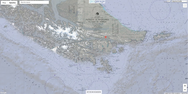
Beagle Canal with the GeoGarage platform (NGA nautical raster chart)
 
 
Martillo Island, a speck of land in the Beagle Channel, regularly attracts tourist boats owing to its photogenic colonies of magellanic and gentoo penguins.
Visit today, however, and you may just be lucky enough to spot an outsider: a king penguin, staring out across the channel from the island’s pebble beach, head and shoulders taller than the gentoos and about twice the size of the magellanics.

A handful of king penguins have been caught by camera traps on the islands, often hanging out in the gentoo nesting grounds.
King penguins can be found elsewhere in Patagonia, but hadn’t been spotted on this island before.
How they got there, where they came from, or even how many there are, is a mystery.
“We don’t know anything about king penguins at Martillo Island,” says Sami Dodino, a penguinologist at Argentinian scientific institute CADIC.

Ushuaia, right at the southern tip of Argentina, is known fondly as “The End of the World.” Travel around 1,000 km south and the next place you reach is Antarctica (although not before passing through another settlement on the Chilean side of the Beagle Channel, Puerto Williams—“Beyond the End of the World”).
Martillo Island has been home to magellanic penguins, small birds which are unusual in that they dig burrows to nest in, since the 1970s, and welcomed gentoos, a larger species which collects rocks to build nests on the ground, in the 1990s.
King penguins look more like the kind you probably first picture when you imagine a penguin.
The second-largest species after the emperor penguin, they have distinctive orange “cheeks” and yellow-orange plumage at the top of their chest.
The adults are elegant in stature, the chicks endearingly awkward in their rotund brown fuzziness.

Whether these few king penguins arrived at Martillo Island by accident or design is unknown.
“Probably it’s an accident,” says CADIC researcher Andrea Raya Rey.
“They were wandering around the ocean looking for food.”
When it is time to moult, king penguins head ashore—usually back to their original colony—before returning to the ocean.
But in this case, they may have looked around, seen the other species of penguins on Martillo Island, and landed there to change their feathers instead.
“King penguins are really long-distance foragers, so they expand their range,” Raya Rey says.

The researchers know from genetic testing that the gentoo colony on Martillo Island originated from individuals that came from the Falkland Islands; there are now around 30 pairs.
The same could be true of the king penguin visitors.
Alternatively, they may have come from Inútil Bay, a few hundred kilometers north in Chile; Staten Island over to the east; or the island of South Georgia, which has a large king penguin colony, out in the Atlantic.

When the king penguins were first observed at Martillo Island, the researchers believe they may have been juveniles, as they didn’t appear to try to breed.
But in the past few years, one pair has managed to lay an egg.
Last year, for the first time, they successfully hatched a chick.

Sadly the excitement didn’t last long, as the chick died a few weeks later.
“We believe maybe that was because we had a hot summer for Ushuaia,” Dodino says.
Raya Rey adds that the chick would have probably died come winter in any case, as the parents were likely inexperienced and at a disadvantage owing to their small group.
Usually, king penguin chicks gather together in winter for warmth while their parents hunt for food; this doesn’t work with just one chick.
“They are trying to start a new colony, but it's very difficult for just a few individuals,” she says.

It’s hard to know what will happen next with the Martillo Island king penguins

The researchers don’t want to do anything that may disturb the few king penguins that are there, so they are limited to studying footage from camera traps.
But this is not detailed enough to reveal how old the penguins are, what sex they are, or even how many there are, as it is not possible to tell if the same penguins keep coming back or if they are different individuals.
“We have a lot of questions without answers,” Dodino says.

In the meantime, more work is being done with the gentoo and magellanic populations.
Raya Rey and Dodino conduct surveys to count the number of penguins in the colony; collect blood and feather samples, which give information on the penguins’ diets; and put GPS transponders on some penguins to see where they fish.
One paper coauthored by Raya Rey found that the gentoo and magellanic penguins on Martillo Island forage in different zones, with gentoo preferring to catch fish in open water and magellanic traveling across a greater area and going after sprat, lobster, and krill close to the seafloor.
This, she says, could be a sign that the penguin species, which are both quite adaptable in their behavior, are segregating the area so as to avoid competition.

But studying any of the penguins at Martillo Island in the past year has been challenging.
The researchers have not been able to visit due to the pandemic, save for one trip to replace the batteries and memory cards in their camera traps.
“I think this year we are going to lose the season, in terms of research,” Dodino says—although, she adds, the penguins may be happier that way.

Studying penguins, at Martillo Island and elsewhere, can tell us about more than just these particular seabirds.
“Penguins in general are sentinels of the marine environment,” Raya Rey says.
“By studying the penguins, I could understand the marine environment for the better conservation not only of the species, but of the habitat.”
Seeing how penguins adapt their behavior could highlight some of the consequences of the climate crisis and other environmental challenges.
“By studying the penguins, you could have an early alert of what is happening in the ocean.”
 

Wednesday, September 6, 2023

China’s new national map has set off a wave of protests. Why?

 
A new China map shows the South China Sea with nine-dash line claims under Chinese territory and a new line next to Taiwan are seen on the map, at a bookstore in Beijing, Friday, Sept.
1, 2023.China has upset many in the Asia-Pacific region with the release of a new official map that lays claim to most of the South China Sea, as well as contested parts of India and Russia, and official objections continue to mount.
(AP Photo/Andy Wong)


From WashingtonTimes by AP
 
China has upset many countries in the Asia-Pacific region with its release of a new official map that lays claim to most of the South China Sea, as well as to contested parts of India and Russia, and official objections continue to mount.
What is the map, and why is it upsetting people so much?

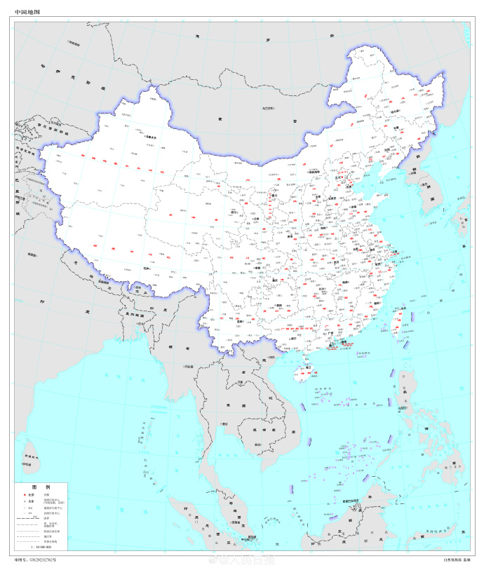
China‘s Ministry of Natural Resources released the new “standard” national map on Monday, part of what it has called an ongoing effort to eliminate “problem maps.” In it, China clearly shows its so-called nine-dash line, demarcating what it considers its maritime border, claiming almost the entirety of the South China Sea.
The current, and other recent iterations of the annual map, include a 10th dash to the east of Taiwan.
     China's new map showing parts of several countries, such as India and Russia, as its own 
The map shows new territorial borders, but the land grab has sparked protest from India, Malaysia and others
 
 Outlay of the multiple nations claimed by China’s 2023 edition of Standard Map.
 
In the far northeastern corner of China on the border with Russia, it shows Bolshoy Ussuriysky Island, an island at the confluence of the Amur and Ussuri rivers, as Chinese territory, even though the countries signed an agreement nearly 20 years ago to split the island.

Along the southern border with India, it shows Arunachal Pradesh and the Doklam Plateau, over which China and India have long feuded, clearly within Chinese borders, along with Aksai Chin in the western section that China controls but India still claims.

China‘s longstanding claims in the South China Sea have brought it into tense standoffs with Indonesia, Vietnam, Malaysia, Brunei and the Philippines, all of which have competing claims.
Chinaand India fought a war over their border in 1962, and the disputed boundary has led to a three-year standoff between tens of thousands of Indian and Chinese soldiers in the Ladakh area.
A clash three years ago in the region killed 20 Indian soldiers and four Chinese.

After the release of the map, India fired back first, saying China‘s claims have no basis.
Indian External Affairs Ministry spokesperson Arindam Bagchi said “such steps by the Chinese side only complicate the resolution of the boundary question.” It lodged a formal complaint on Tuesday through diplomatic channels.

Malaysia then rejected China’s “unilateral claims” and added that the map is “not binding” to the country.
Vietnam, Taiwan, Indonesia and the Philippines have since followed suit.

Vietnam said the claims violate its sovereignty over the Paracel and Spratly islands and jurisdiction over its waters and should be considered void because they violate the United Nations Convention on the Law of the Sea.
Illustrating how provocative the nine-dash line is considered by Hanoi, Vietnam in July banned the popular “Barbie” movie because it includes a view of a map showing the disputed Chinese claims.

The self-governed island of Taiwan, which China claims as its own, also rejects the nine-dash line and Beijing’s South China Sea claims.

1671 Dutch map of China by Arnoldus Montanus (in Latin)
 
The territorial claims at times lead to direct confrontation.
A little more than a week ago, Philippine boats breached a Chinese coast guard blockade in a disputed area of the South China Sea to deliver supplies to Filipino forces guarding a contested shoal.

In its response to the map, the Philippine Department of Foreign Affairs cited a 2016 ruling by an arbitration tribunal in The Hague under the U.N.
Convention on the Law of the Sea that largely invalidated China’s claim to virtually the entire South China Sea and upheld the Philippines’ control over resources in a 200-nautical mile exclusive economic zone.

Russia, for which Chinese support in its war against Ukraine has been critical, has not yet responded.

Chinese Foreign Ministry spokesperson Wang Wenbin sidestepped questions Thursday about specifics of the nine-dash line and why China has been using a 10th dash in recent years, telling reporters only that “China‘s stance on the South China Sea is consistent and clear.”

He also didn’t directly address the protests over the map, saying that the update was “routine practice every year” with the aim of providing standard maps and to “educate the public to use maps in accordance with rules.”
“We hope that the relevant sides can see it in an objective and rational way,” he said.

World map according to Ming dynasty in 1602

The national map is an annual production that could be released any time, and China knows well that its claims are contentious, even though they are not new.

It seems significant, then, that Beijing chose to release the map on the heels of a late August meeting of the BRICS nations - Brazil, Russia, India, China and South Africa — and just before China is to participate in top-level meetings of the Association of Southeast Asian Nations and the Group of 20 rich and developing nations.

At the BRICS meetings, the China-Russia relationship was broadly seen as strengthened as the group voted in favor of a proposal pushed by Beijing and Moscow to invite Iran and Saudi Arabia, along with four other countries, to join.
On the sidelines, Indian Prime Minister Narendra Modi and Chinese President Xi Jinping even talked about their disputed border, agreeing to intensify efforts to de-escalate tensions.

Most of the governments with which China has disputes in the South China Sea are ASEAN members, and India is hosting the G20 talks.

In releasing the map now, Beijing is widely seen as signaling it has no intention of backing down on any of its claims and is making sure that its positions are fresh in the minds of other countries in the region.

Links :

Tuesday, September 5, 2023

AIS data : the danger in the hands of novices


From Navigate Response by Dustin Eno


In the hands of people without an adequate understanding of our industry AIS data causes problems

Automated Identification System (AIS) data is a valuable tool for tracking ships and maritime activities.
It is used by various parties, including journalists, researchers, and the public, to monitor vessel movements and gather information about shipping trends.
However, despite the fantastic user interfaces created by platforms like MarineTraffic, AIS data is too often misinterpreted, leading to incorrect conclusions and false narratives.

In the hands of people without an adequate understanding of our industry AIS data causes problems which fall roughly into three categories:

Errors in AIS data that are obvious with context, but that are nevertheless not questioned and are instead taken as fact.

In 2019, as oil was washing up on Brazilian beaches, investigators were trying to identify the source of the spill.
The Brazilian Laboratory of Satellite Image Analysis and Processing looked at satellite imagery to track the oil at sea and then used AIS data to identify which vessels had been in the area.

One ship was identified and an “expert” presented the vessel’s name to a senate committee and the public as the culprit.
There was just one problem, the vessel was 12,000km away in India at the time.
An error in the AIS data showed her in the Atlantic for about 24 hours around the time the spill was believed to have happen.
Obviously, it would be impossible for a large tanker to relocate from India to Brazil and back in the span of a couple days.
Some involved indicated that the “unusual” movement of the vessel was part of the reason she was suspected.
Unusual? Try impossible! But the data was not doubted as it should have been.

We were able help our client to clear their name, but it took weeks to get all the allegations removed.
With a little critical analysis of the data, the vessel never should have been under suspicion in the first place.

Switching AIS to low power mode is misinterpreted as going “dark” for nefarious purposes.

As a safety precaution, the power setting on the AIS units on tankers is routinely reduced from 12.5W to 1W while the vessel is berthed or engaged in cargo operations.
If an AIS receiver is nearby this will have no impact and the data will still be received without interruption, but if the receiver is further away it may no longer be able to pick up the weaker signal and this could be mistaken for the tanker turning off its AIS – perhaps to hide while doing something wrong…

We see this issue arise during ship to ship (STS) transfer operations which generally happen in more remote areas farther from receivers.
It is true that some operators do turn off their AIS to hide STS operations (for example if in breach of sanctions).
Unfortunately, some observers also assume this is what has happened in completely innocent cases when in fact the AIS has just been switched to low power mode as per standard operating procedures.

We’ve dealt with numerous enquiries from well-intentioned journalists along the lines of:“your client’s vessel arrived at _______ turned off her AIS and, when she turned it back on, had a larger draft suggesting she’d loaded cargo in an STS operation.
Why was the AIS turned off?
What is she hiding?”

Convincing a journalist, or worse an activist, that in fact the AIS was on the whole time is difficult, especially if they believe they’ve caught the vessel / company in the act of doing something dodgy.
 
 
Attacking Open Source Intelligence: The Fake AIS data epidemic explained
Everyone (and their mother) has discovered AIS signals. 
When there is a major confrontation at sea, or a ship gets stuck in the Suez Canal, it's a race to the data used to track ships.
But like any form of Open Source Intelligence (OSINT) the signals you get may be misleading.
They may even be fake.
In fact tat is happening more and more frequently.
Here's how. Article on Yantar spy ship http://www.hisutton.com/Yantar.html
 
The AIS track on a map is visually easy to interpret, but only tells one part of the story and without context can be badly misleading.

One AIS platform famously caught the Ever Given “drawing” male genitals in the southern Suez anchorage before going on to blook the canal some hours later.
Of course, the pattern was purely coincidental and was visible only on this platform due to the exact moments that they captured the data.
On all other platforms the track of the vessel looked purely random.

A vessel drifting in the Baltic Sea last year was absurdly accused by some on Twitter of being involved in damaging to the Nord Stream pipeline simply because she was floating in the rough proximity of the damage at roughly the same time while awaiting orders.

In another story, tanker 1 called in Russia and then a couple weeks later met tanker 2 which had come from Iraq via Turkey; after meeting tanker 2 proceeded to Greece.
A journalist with a major outlet reported that an STS operation moved Russian oil from tanker 1 to tanker 2 so that it could be imported into Greece.
In reality, tanker 2 needed an unscheduled drydock and so transferred the remainder of its Iraqi cargo to tanker 1 and arrived in Greece empty ready for drydocking.

All understandable conclusions if one approaches the data with suspicion and doesn’t check the fuller context, but all wrong.
And obviously wrong with a little investigation.

What’s the conclusion?

It is easy to be angry with the social media users and journalists who make accusations based only on an incomplete understanding of AIS data.
Being angry is justified, but not useful.

Instead, these misunderstandings and assumptions, most of which stem from a distrust of our industry, are a reminder that as an industry we must continue to do more to explain our operations.

Explain AIS data.
And build trust with our ultimate stakeholders – the general public.

Links :
 

Monday, September 4, 2023

Globalstar enlists Elon Musk’s SpaceX to launch satellites for Apple's iPhone SOS feature

Globalstar, a Covington-based communications company, has been selected to serve as the satellite operator for Apple’s new emergency SOS service
 
From NOLA 

Globalstar has enlisted Elon Musk’s SpaceX to launch a host of satellites it will use to provide a communications network for an emergency Apple iPhone feature, the Covington satellite technology firm said Thursday in a federal filing.
 
 As part of a deal signed Monday, Globalstar will have to pay SpaceX a total of $64 million for “launch-related payments on a periodic basis” from now until the satellites are sent into space in 2025, according to its Securities and Exchange Commission filing. SpaceX is the spacecraft manufacturer founded by Musk, who is CEO of Tesla and owns X, the social media platform formerly known as Twitter.

The satellites will support the emergency SOS services Globalstar is providing to Apple’s iPhones.
The feature allows iPhone 14 users to tap into satellite networks to send messages or calls if they are far away from cell towers.

Globalstar bought those satellites in February 2022 from Canadian company Macdonald, Dettwiler and Associates Corp. for $327 million.
Apple loaned Globalstar $252 million to help finance that purchase.

This isn’t the first time Musk’s launch company has helped Globalstar.
Last year, SpaceX helped Globalstar launch a satellite from the Kennedy Space Center in Cape Canaveral, Florida.

Globalstar made waves earlier this week when it announced it would hire Paul Jacobs, a Silicon Valley darling and former Qualcomm executive, as its CEO.
 
Links :


Keeping tabs on China’s murky maritime manoeuvres

Chinese fishing fleet (August 16th)

From The Economist

America and its allies are using whizzy new tools to track China’s military activity and illegal fishing

In january 2021 a fleet of Chinese fishing vessels approached the coast of Oman, apparently searching for squid.
According to the ships’ automatic identification transponders, they stayed just outside Oman’s Exclusive Economic Zone (eez), which grants it control of fishing rights up to 200 nautical miles (370km) from its shores.
But radio signals from the ships, detected by commercial satellites, told a different story.
They indicated that the ships were operating within Oman’s eez in a suspected illegal raid on the Gulf state’s valuable squid stocks.

That was an early demonstration of a new tool being used by America and its allies to help expose illegal or aggressive Chinese activity at sea.
They are contracting private companies to provide governments across the Indo-Pacific region with near-real-time data, gathered from space, to help them monitor coastal waters and to use their limited naval and coast-guard resources more effectively.

The data are being provided as part of the Indo-Pacific Maritime Domain Awareness initiative, or ipmda, which was launched in May 2022 at the second leader’s summit of the “Quad”—a bloc comprising America, Australia, India and Japan.
It is now one of the clearer examples of how that grouping is trying to add substance to its rhetoric about defending a “free and open” Indo-Pacific against Chinese military and economic coercion.

But it also highlights the sensitivities involved in a region where many countries fret about China’s military activity and illegal fishing, but are wary of challenging it directly or being drawn into its escalating confrontation with America.
The Chinese government has already indicated that it sees the ipmda as part of an American-led effort to “build small cliques and stoke bloc confrontation” against China.

When the Quad’s leaders met again in May 2023, they said that the ipmda was already providing data to governments in South-East Asia and the Pacific, and would expand to the Indian Ocean in the coming months.
They avoided mentioning China, emphasising instead the data’s utility in combating illegal, unreported or unregulated fishing, and in responding to humanitarian crises.

At a security conference the next month, however, American and allied military commanders emphasised the strategic significance of the programme whereby information is shared through data “fusion centres” in India, Singapore, Vanuatu and the Solomon Islands (see map).
These have existed for some years but have not shared data fast enough or in sufficient detail.
Individual governments have also been wary of sharing classified information.


“The architecture’s there,” Admiral John Aquilino, commander of America’s Indo-Pacific Command, told a panel session at the conference in June.
“The sensing needs to be increased and then the sharing needs to be done” in the Indian Ocean region, he said, suggesting that a maritime security centre in Oman could be included.

On the same panel, India’s deputy national security adviser, Vikram Misri, said the fusion centre just outside Delhi had already exchanged data with more than 22 countries and hosted liaison officers from nearly a dozen.
France’s chief of navy staff, Admiral Pierre Vandier, called for efforts to combine military and civilian tools, and suggested incorporating another data centre in Madagascar to help cover the southern Indian Ocean.

Chinese experts, meanwhile, say the ipmda is designed to discredit China’s maritime activities, especially those of its vast fishing fleet, which has been accused of illegal operations around Africa, South America and the Pacific islands.
The Quad’s programme will soon expand to target Chinese coast guard and navy ships, predicts Hu Bo of Peking University.

Western defence experts, too, have highlighted the IPMDA’s military applications.
It “develops organisational infrastructure and surveillance practices that the Quad and its partners could repurpose for military operations, including monitoring a Chinese move against Taiwan,” the Centre for Strategic and Budgetary Assessments, a Washington-based think-tank, said in July.
It suggested augmenting the programme with aerial drones.

Quad officials are reluctant to say exactly which countries see the data.
But America’s vice-president, Kamala Harris, revealed that the Philippines was among them when she visited there in November.
That country has been revitalising its alliance with America in recent years, largely in response to China’s efforts to enforce its maritime claims in the South China Sea, which are disputed by the Philippines and four other South-East Asian countries.

One of the challenges for those countries is that Chinese coast-guard and fishing vessels help to enforce maritime claims but often deactivate the Automatic Identification System (ais) transponders that broadcast their identity and location.
At other times, Chinese ships transmit “spoofed” data, manipulated to be inaccurate.
Chinese survey vessels have also operated across the Indo-Pacific without transmitting AIS data in recent years.

Even Chinese cargo ships have become harder to track using conventional methods since 2021, when many stopped transmitting ais data following passage of a new law that China said was necessary to thwart foreign intelligence-gathering.
However, new means of ocean surveillance are emerging thanks to private satellite operators offering services including high-resolution photography, radio-frequency monitoring and synthetic-aperture radar (which generates images by bouncing microwaves off the Earth’s surface).
Artificial intelligence also enables much faster analysis of such data and imagery.

The view from on high

Among ipmda’s contractors is HawkEye 360, a Virginia-based company founded in 2015.
It operates a constellation of 21 low-Earth orbit satellites monitoring the radio-frequency signals from navigation, security and communication equipment that ships use even if ais transponders are deactivated.
That can then be cross-referenced with satellite images and other information to identify and locate ships.

HawkEye 360 says it used its data to help identify Chinese vessels suspected of illegal fishing off Ecuador in 2020, as well as the squid-fishing fleet near Oman in 2021.
It has also tracked Chinese coast-guard vessels in disputed parts of the South China Sea.
Its satellites can now cover about 10m sq km in one pass and another cluster can return to the same area within about 60 minutes, says John Serafini, the firm’s chief executive.
Getting data to clients can take between a few minutes and an hour, he adds.

The company declined to specify the value of its ipmda contract but said that it provides the data directly to the American government, which then distributes it to the programme’s participants.
In addition, the Australian government contracted HawkEye 360 in July to provide its data to the Pacific Islands Forum Fisheries Agency, which helps its 17 member countries to manage their tuna stocks.

That agency is based in the Solomon Islands, which caused alarm among American and allied officials in 2022 when it signed a security agreement with China that they fear could lead to a Chinese military base there.
China and the Solomons deny any such plans but America and its main regional ally, Australia, have since expanded their diplomatic contacts with the Pacific islands and offered to boost financial and military assistance.

The hope now among Western officials is that by focusing such efforts on illegal fishing and other areas of real concern to Indo-Pacific nations, they will win broader support for American and allied efforts to counter China.
Whether that will alter Chinese behaviour is another question: fishing and territorial claims are both touchy issues for its leadership.
But shining a light on murky maritime manoeuvres seems like a good place to start.


Links :