An Island Off An Island from Guido Pezz For the past 20 years, Jenene and John have carried a simple life together in Bruny; an island off the island of Tasmania, at the bottom end of Australia. This film is an intimate portrait about life away from the distractions of the outside world.
Bruny island with the GeoGarage platform (AHS nautical raster chart)
The 2023 Egypt mission of the European Institute for Underwater Archaeology (IEASM), directed by Franck Goddio, in the sunken city of Thonis-Heracleion revealed new ancient treasures and secrets from the great temple of Amun Gereb and its surroundings.
The ancient city of Heracleion was situated northeast of Alexandria at the mouth of the Nile River. During its peak, Heracleion was a bustling maritime city that played an important role in shaping Egyptian history and the broader cultural history of the ancient Mediterranean.
Its strategic location on the mouth of the Nile made it an international melting pot that helped spread the exchange of goods, ideas, and cultures.
Merchants and travelers from Greece, Phoenicia, and beyond docked their ships at this thriving metropolis and contributed to cultural exchange.
Foreign influences also helped to impact the art, architecture, and religious practices in Egypt.
During the second century BC, the nearby city of Alexandria began to gradually take precedence over Heracleion as Egypt’s principal port. This contributed to its decline.
This diminishing importance of Heracleion was exacerbated when a major natural disaster significantly damaged the city.
Researchers have tossed around the possibility that a tsunami, earthquake, or a combination of both, could have been responsible.
Around 101 BC, the very ground on which Heracleion rested experienced what is known as soil liquefaction.
A phenomenon that turned the once-sturdy clay terrain into a watery swamp, swallowing the grand temples and accelerating the city’s demise.
However, despite its decline, the city wasn’t entirely deserted until it was completely consumed by the Mediterranean Sea sometime during the eighth century AD.
Heracleion disappeared beneath the Mediterranean around 1,200 years ago
CREDIT: Photo: Franck Goddio/Hilti Foundation, graphic: Yann Bernard
Discovery and Rediscovery
Ancient accounts of Heracleion date back to the writings of ancient historians such as Herodotus and Strabo, who marveled at its beauty and rich culture.
Originally it was believed that Heracleion and the city of Thonis were one and the same.
But it was discovered later that “Thonis” was the Greek name for Heracleion.
This revealed that the Greeks were trading with the Egyptians earlier than previously thought.
For centuries, the ancient city of Heracleion remained lost, a figment in the realm of myth and folklore. That is until 2001 when French archaeologist, Franck Goddio and his team, used historical texts, nuclear magnetic resonance magnetometers, bathymetry, and sonar to locate and map the submerged ruins.
Goddio and his team began mapping the area around the port of Alexandria in 1992. Four years later they broadened their search into the Aboukir Bay.
That’s when their mapping equipment picked up strange anomalies on the ocean floor.
Upon closer inspection, it was revealed that the ancient city was covered with sediment deposited by the Nile River.
This was because the city was built on the Nile delta where the river emptied into the sea.
This helped researchers understand why the city was lost for so long. It was buried beneath the ocean floor.
Underwater Archaeological Expeditions
After the city was rediscovered in the early 21st century, archaeologists attempted to survey and map the city.
But its depth has made that objective very difficult.
Some areas of Heracleion lie over 30 meters beneath the Mediterranean Sea.
To help in their search, archaeologists use advanced diving equipment, remotely operated vehicles (ROVs), and sonar technology to navigate and excavate the submerged site.
These expeditions have revealed a wealth of remarkably preserved artifacts, statues, and intricate temple complexes.
The artifacts provide a glimpse into the daily life of ancient Egypt and its role in the ancient world, and the legacy it left behind.
Remarkable Artifacts and Findings
The underwater excavations at Heracleion have yielded a treasure trove of artifacts that will keep researchers busy for years.
By studying them, researchers can build a better understanding of what life was like in the 8th century BC.
The presence of Greek inscriptions and the evidence of trade connections have revealed that ancient Egypt was a more international influence than was previously known.
Some of the more notable discoveries found at the site include:
Statue of Hapi: One of the most exciting discoveries that have been made is the colossal statue of a pharaoh believed to be a representation of Hapi, the god of the annual flooding of the Nile.The sheer size and detail of this statue underscores how important the Nile was in the lives of ancient Egyptians.
Intricate Temple Structures: The remnants of the Temple of Amun-Gereb, showcase the religious significance of Heracleion.
These temples played a central role in ancient Egyptian spirituality and were centers of worship and rituals.
Everyday Objects: Artifacts like pottery, jewelry, and glassware provide insights into the daily life of the city’s inhabitants.
Heracleion’s Influence on Modern Culture
The rediscovery of Heracleion has not only enriched the world’s historical understanding but has also ignited curiosity and creativity in contemporary culture.
It has inspired various forms of artistic media including documentaries, books, and exhibits where people can learn more about this fascinating city.
Conclusion
The sunken city of Heracleion offers a fascinating window into the past.
This ancient city has unveiled remarkable insights into the ancient Egyptian civilization, its cultural richness, and its prominence as a vital trading and religious center.
The ongoing explorations of Heracleion continue to reveal secrets from its past and shed light on the life of ancient Egypt.
Documentaries: Documentaries like “Heracleion: Sunken City of Egypt” and
“Lost Worlds: The Sunken City of Heracleion” have delved into the
city’s history and the underwater archaeological expeditions that led to
its discovery.
Books: Works like “Heracleion: The City of Herakles” and “Egypt’s Lost City: The Watery Grave of Heracleion” explore the city’s history, significance, and the profound impact of its rediscovery.
Exhibitions:
Museums and cultural institutions have showcased artifacts and findings
from the underwater site. Exhibitions such as “Heracleion: The Legend
Revealed” provide a deeper appreciation of its significance in ancient
Egypt.
Tracking recent environmental changes, with 12 essays prepared by an international team of 82 researchers from 13 different countries and an independent peer review organized by the Arctic Monitoring and Assessment Programme of the Arctic Council 00:00 - Intro 00:05 - Extreme weather 00:18 - Arctic animation 00:42 - Greenland Ice Sheet 00:47 - Tundra greening 01:05 - Wildfire in Canada 01:16 - Arctic communities and Indigenous peoples 01:44 - Western Alaska salmon 02:21 - Finland peatlands restoration
Please go online to view Arctic Report Card infographics on key findings, air temperature, sea surface temperature, sea ice, snow cover, tundra vegetation, Finland's peatland restoration and overall Arctic warming.
Guy
Omnik observing the sea ice near Point Hope, Alaska, in January 2020 as
part of the Alaska Arctic Observatory and Knowledge Hub. (Image
credit: Caroline Nashookpuk)
NOAA’s 2023 Arctic Report Card documents new records showing that human-caused warming of the air, ocean and land is affecting people, ecosystems and communities across the Arctic region, which is heating up faster than any other part of the world.
Summer surface air temperatures during 2023 were the warmest ever observed in the Arctic, while the highest point on Greenland’s ice sheet experienced melting for only the fifth time in the 34-year record. Overall, it was the Arctic’s sixth-warmest year on record. Sea ice extent continued to decline, with the last 17 Septembers now registering as the lowest on record. These records followed two years when unprecedented high abundance of sockeye salmon in western Alaska’s Bristol Bay contrasted with record-low Chinook and chum salmon that led to fishery closures on the Yukon River and other Bering Sea tributaries.
“The overriding message from this year’s report card is that the time for action is now,” said Rick Spinrad, Ph.D., NOAA administrator. “NOAA and our federal partners have ramped up our support and collaboration with state, tribal and local communities to help build climate resilience. At the same time, we as a nation and global community must dramatically reduce greenhouse gas emissions that are driving these changes.”
The annual Arctic Report Card, now in its 18th year, is the work of 82 authors from 13 countries. It includes a section titled Vital Signs, that updates eight measures of physical and biological changes, four chapters on emerging issues and a special report on the 2023 summer of extreme wildfires.
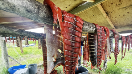
Salmon dries on a rack in Quinhagak, Alaska in July 2023. (Image credit: Alice Bailey)
Divergent climate impacts on salmon fisheries
One new chapter in the report focuses on salmon species that are vital to the health, cultures and food security of many Indigenous communities as well as to commercial fishing economies. During 2021 and 2022, sockeye salmon, a staple of commercial fishing, reached record-high abundance in Bristol Bay, Alaska, while Chinook and chum salmon, fished by Indigenous communities in the Yukon and Kuskokwim rivers, fell to record-low abundance. Declining fisheries have continued into 2023 with fishing closures.
Chinook and chum salmon numbers have declined following recent heatwaves and ecosystem changes in the rivers where they spawn and the ocean waters where they grow to maturity. Warming river waters have been linked to heat stress in Chinook salmon, and warmer ocean waters may be contributing to both species maturing as smaller adults.
Contrastingly, sockeye have been extremely successful under recent warm conditions, which allow them to grow faster in lakes as juveniles and may boost their survival when they migrate to the ocean. The diverging impacts are affecting Indigenous communities that depend on the salmon for food, and challenging fishery managers as the different species respond in unique ways to the warming climate.
Indigenous knowledge strengthens science and resilience
The 2023 report card features two chapters on the importance of implementing Indigenous knowledge for the future resilience of the Arctic. One chapter describes the work of the Alaska Arctic Observatory and Knowledge Huboffsite link, a collaboration between University of Alaska scientists and a network of Iñupiaq observers who are documenting long-term environmental change and social and cultural impacts on their northern Alaska communities.
The value of Indigenous and local knowledge to help tackle environmental challenges is also central to a chapter on the restoration of peatlands and boreal forests in Finland, where Indigenous Sámi people and Finnish villages are working with scientists to restore these wetland ecosystems and forests.
Over the last two decades, the Finnish nonprofit Snowchange Cooperativeoffsite link has restored dozens of sites, positively influencing 128,000 acres (52,000 hectares) of peatlands and forest damaged by decades of industrial harvesting and forest management. The restoration demonstrates a globally relevant climate solution that increases carbon storage, preventing greenhouse gas emissions from entering the atmosphere. The restored peatlands are also restoring water quality and bringing back fish and birds, a vital food source and draw for ecotourism.
Another new chapter delves into the little-known topic of subsea permafrost, a potential source of greenhouse gas emissions. For thousands of years as the world emerged from the last ice age, rising ocean waters in the Arctic continued to cover more and more permafrost, transforming it into subsea permafrost. The Arctic has an estimated 965,000 square miles of subsea permafrost, a fifth of the amount of permafrost found on land. International research collaboration is needed to address questions about the extent and current state of subsea permafrost and to estimate the potential release of greenhouse gases as it thaws.
Major annual updates of Vital Signs for 2023
Summer (July-September) 2023 was the Arctic's hottest on record. Map: Some areas, including northern Alaska and Canada, were 7.2 degrees Fahrenheit or more (darkest red) above the 1991-2020 average. Graph: Summer temperature compared to average each year from 1940-2023. Warming has accelerated in recent decades, reaching a new record in 2023. NOAA Climate.gov images, adapted from the 2023 Arctic Report Card. (Image credit: NOAA)
The average surface air temperature in the Arctic this past year was the sixth warmest since 1900 at 20 degrees Fahrenheit (-7 Celsius). The summer Arctic average temperature was the warmest on record at 43 degrees Fahrenheit (6.4 Celsius). Data shows that since 1940, annual average temperatures have risen .45 of a degree Fahrenheit (.25 of a degree Celsius) per decade and average summer temperatures have risen .31 of a degree Fahrenheit (.17 of a degree Celsius) per decade.
Sea ice extent continues to decline, with the 17 lowest Arctic sea ice extents on record occurring during the last 17 years. This year’s sea ice extent was the sixth lowest in the satellite record, which began in 1979, with older, thicker multi-year ice far less than in the 1980s.
Mean sea surface temperatures in August 2023 were 9 to 13 degrees Fahrenheit (5-7 degrees Celsius) warmer than the 1991-2020 August mean values in the Barents, Kara, Laptev and Beaufort seas. Unusually cool August temperatures were observed in Baffin Bay, Greenland Sea and parts of the Chukchi Sea. August mean sea surface temperatures show warming trends for the period from 1982 to 2023 in areas of the Arctic Ocean that are ice free in August, with mean sea surface temperature increases of nearly a degree Fahrenheit (.5 of a degree Celsius) per decade.
Arctic Ocean regions, except for the Canadian Archipelago, Chukchi and Beaufort seas, continue to show increased ocean phytoplankton blooms, or primary productivity, with the largest percent increases in Eurasian Arctic and Barents Sea.
North American snow cover set a record low in May 2023, while snow accumulation during the 2022-2023 winter was above average across both North America and Eurasia.
Heavy precipitation events broke existing records at various locations across the Arctic, with some variation such as a dry summer in northern Canada, contributing to record wildfires. Pan-Arctic precipitation was the sixth highest on record, continuing the trend toward a wetter Arctic.
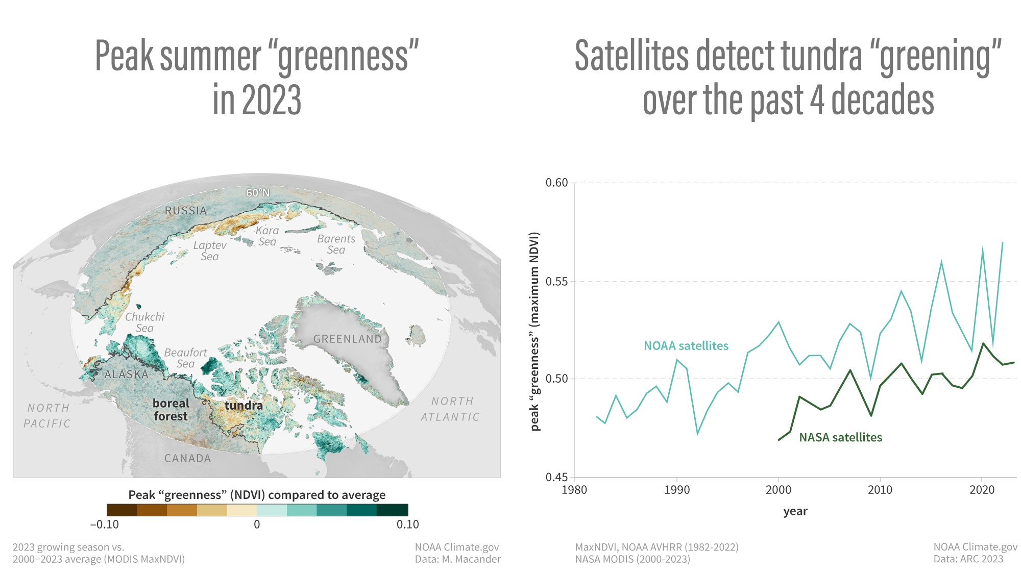
Map: Peak summer "greenness" — a satellite measure of the amount and health of vegetation — was higher than average across the tundra in summer 2023, with especially high values (darkest green) in the North American Arctic. Graph: The peak "greenness" reached each summer in the tundra has increased over time. The greening of the Arctic is strongly influenced by rising air temperatures. The result is leafier vegetation: an increase in grasses, grass-like sedges, and shrubs in areas once dominated by lichens, mosses, and smaller herbs. NOAA Climate.gov images, adapted from the 2023 Arctic Report Card.(Image credit: NOAA)
Tundra greenness across the Arctic was the third highest in the 24-year satellite record, a slight increase over 2022. The Arctic continues a trend of increased shrubs, willows and alders where once there was tundra.
The Greenland Ice Sheet continued to lose mass despite above-average winter snow accumulation. Summit Station, the highest point on the ice sheet, reached a temperature of 32.7 degrees Fahrenheit on June 26, 2023, experiencing melting for only the fifth time in the 34-year record.
Here’s a little story for you to round out the month, starting with a perhaps unexpected mini-biography and ending in a volcanically-themed clash.
So, I’m half-Maltese. Genetically speaking, that doesn’t mean much, considering that the tiny island nation – which makes incredible, cheese-filled pastitsies, has glorious coves and cacophonous, Sun-painted streets – has been invaded and occupied by pretty much every nearby major power dating back around 7,200 years.
From the Phoenicians and the Romans to the Arabs and the Sicilians, from the French and the Spanish to the British and now hordes of tourists and everyone in-between, this little, staunchly Catholic part of the world, this micro-land sticking up from a colossal underwater ridge, has been visited and enjoyed by all.
As such, its genetics and language have been borrowed from all over the region – so Maltese people are eccentric mishmashes of humans, with a rich history and no time for blasphemy.
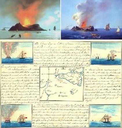
Map with the location of Graham (Ferdinandea) Island, emerged from the sea in 1831, Sicily, Italy.
The point here is that, apart from its other natural resources, it happens to occupy a little part of the Mediterranean that’s a strategic godsend.
Poking its head above the waves between Sicily and North Africa, it’s been subjected to countless sieges and military campaigns.
Rather famously, during that most recent of global military conflicts, it held its nerve – despite the fact that, in 1942, it became the most bombed place on Earth.
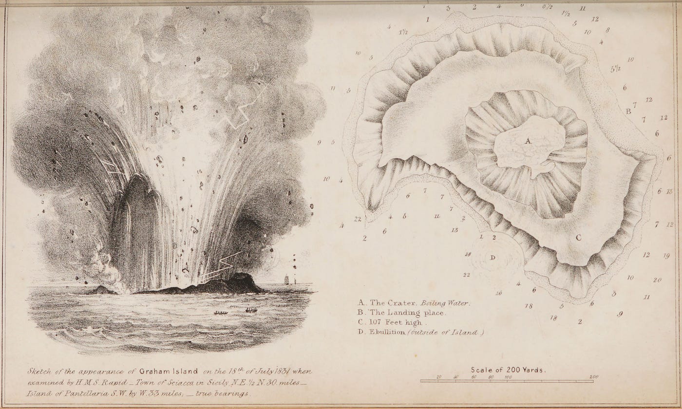
A page out of the field journal of French geologist Constant Prévost.
Illustrations by a French artist.
As such, from my personal experience, the residents of said island are ferociously proud of their miniature paradoxical paradise, and any territory they happen to have.
That’s why, back in 1831, the emergence of a volcano off its coast caused a fair bit of fuss when it became the subject of a territorial dispute.
Back then, Malta was a relatively new addition of the British Empire.
In the summer of that year, according to The Independent, an earthquake along the southern Sicilian coast, followed by fire and brimstone emerging from the waves, shocked all who observed it.
It transpired that an underwater eruption had taken place, and it was powerful enough for some of the debris to make it to the surface.
By signing up, you accept and agree to our Terms of Service (including the class action waiver and arbitration provisions), and you acknowledge our Privacy Statement.
The British Navy guarded the island as it erupted forth.
Wikimedia Commons : public domain
Sticking up above the waves, this was initially occupied by the British, who did what they do best and stuck a flag in it.
They named it Graham Island after Sir James Robert George Graham, the First Lord of the Admiralty.
The Kingdom of the Two Sicilies – an Italian state that merged the kingdoms of Sicily and Naples – was fairly unhappy with such flagrant flag-planting, and quickly switched it for one of their own.
They even named it Ferdinandea, after its monarch, King Ferdinand II.
Then, just as the French dispatched a geologist to the island, and just before the Spanish were about to make a move, the volcano – whose activity had ceased – was quickly eroded and consumed by the sea, as plenty of volcanic islands tend to do after they’ve finished erupting.
It can be found today just outside Italian territorial waters, just beneath the surface of the Mediterranean’s azure waves.
A descendent of King Ferdinand II managed to get a rather ostentatious marble plaque attached to it, but it was promptly smashed up by a still-unidentified vandal.
This back-and-forth has continued for some time and, in 1987, even America got involved, because of course it did. Back then, US warplanes spotted it and – according to the Geological Society of London – thought it was a Libyan submarine and tried to destroy it using explosive depth charges.
London’s Natural History Museum (NHM) explains how Isola Ferdinandea – as the Italian government refers to it – is actually part of a far larger underwater volcano named Empedocles, whose heart is found 30 kilometers (19 miles) from Sicily.
Although signs of volcanic activity suggested it could once again give the little island enough of a magmatic boost to trigger another ascension above the waves back in 2000 and 2002, this never came to pass.
That didn’t stop the The Telegraph from somehow getting stuck in the middle of it all.
In 2002, one of its reporters flew then boated out to the right spot above the sunken isle and notified the Foreign Office that he was about to claim it for Britain, much to the understandable frustration of his Italian crew mates.
3-D perspective view (vertical exaggeration 4×) of the study area, where the main volcanic, fluid flow and tectonic features are indicated.
The location of the disputed, sunken isle with the GeoGarage platform (Imray nautical chart)
zoom with IIM raster map
Empedocles, itself discovered in 2006, was named after the eponymous Greek philosopher, who once posited that everything is made of four elements: Water, Air, Earth, and Fire.
The emergence of Graham Island – or whatever you wish to call it – from the Mediterranean certainly lived up to the legacy of this philosopher, and its far more massive volcanic progenitor.
Although it’s unlikely that tiny Graham will ever again seek the sky, it’ll long be the site of a somewhat mischievous argument between several nations.
The latest move was made by a PhD student in France, who recently announced a proposal to resume French occupation of the submerged volcanic mound.
That brings us back to Malta – what role does this proud nation of eclectic men and women play in this rather ridiculous tale?
They must've entered the fray at some point or the other, I thought.
Surely the long-occupied nation fancied stealing this tiny volcano away for itself at some point in history.
Well, as far as I can tell, it’s just too far away for the island nation to make any serious (or ludicrous) claim, and I’ve yet to find evidence of one being made in the media.
I ended up asking my grandfather about it, and he’d actually not heard of it until that very moment.
“So, do you fancy having a volcanic island to yourself?”
I asked him this week.
He frowned. “Nah,” he said. Thinking of the frigid nature of the water, he added: “Too cold there, eh?” Volcanoes aren’t for everyone, I suppose.
The Astro Sculptor oil tanker was already showing its age in February 2020 when inspectors reported problems with corroded decks and propulsion machinery on the then 17-year-old Greek-run ship.
But nearly four years later the vessel is still ploughing the oceans — part of the “shadow fleet” of secretively run tankers assembled by the Kremlin and its partners to move Russian oil after its full-scale invasion of Ukraine in February 2022.
This armada of ageing tankers has helped Russia absorb the shock of the extensive western sanctions imposed on it one year ago when the EU banned imports of Russian crude into the bloc and, with the G7 group of industrialised nations, imposed restrictions on those wanting to ship it to other parts of the world.
Under the rules — conceived in June 2022 and enforced in December last year — countries outside the G7, such as India and China, could continue to buy Russian crude but would have to pay less than $60 a barrel if they wanted to use G7-registered ships, trading or insurance services to move the oil. G7 members are the US, Japan, Germany, France, Italy, the UK and Canada. The measures were designed to keep Russian oil on the international market while undermining the Kremlin’s ability to finance its war in Ukraine. Together they have redrawn the global energy map.
Flows of Russian oil into Europe, previously its biggest export market, have shrunk to a trickle. Instead, millions of barrels are shipped every day from Russia’s western ports on the Baltic Sea and Black sea, on a circuitous journey to new buyers, mainly in India, China and Turkey.
But while the EU embargo has been effective in choking off most supplies into the bloc, western officials have acknowledged that 12 months later almost none of the Russian crude flowing to new buyers is selling at under $60 a barrel.
“In the first quarter the cap worked well, in Q2 Russia started to find ways around it, in Q3 the cap was almost over and now in Q4 the cap is definitely done,” said Maximilian Hess, founder of political risk group Enmetena Advisory.
The near universal violation of the price cap has been made possible by weaknesses in enforcement but also by Russia’s success in building a network of vessels, such as the Astro Sculptor, to move its oil, outside the reach of the G7.
“The global crude oil market, which had become highly efficient and globally consistent, is now being bifurcated into essentially two stovepipes, one of which is the shadow fleet and the other of which is the good guys,” Geoffrey Pyatt, US assistant secretary of state for energy resources, told the Financial Times in an interview last week.
Kyiv School of Economics, which has been studying evasion of the price cap, estimated that in October, 99 per cent of seaborne exports of Russian crude were sold at prices above $60 a barrel. Of those shipments, 71 per cent involved vessels and service providers outside of G7 countries, up from only 20 per cent in April 2022.
Kpler, a data and analytics company, divided the vessels moving Russian oil into three main groups: Russian-owned vessels; so-called “dark fleet” vessels previously involved in moving sanctioned crude from Venezuela or Iran; and the “grey fleet” assembled since the invasion. In November, the grey fleet accounted for more than half of oil exports from western Russia for the first time, Kpler’s data shows.
Grey and dark fleet vessels, sometimes collectively called the shadow fleet, use opaque ownership structures, routed through offshore jurisdictions with strong corporate secrecy, to complicate sanctions enforcement on the beneficial owners.
The Astro Sculptor, which was sold in 2022 and renamed the Amber 6, is a typical example of a “grey” fleet vessel. No longer Greek, the tanker is managed by a Chinese company based in the city of Dalian, flies a Liberian flag and no longer holds insurance from a western provider.
Greece-registered vessels remained the second-largest conveyors of Russian crude in November, but their 16mn barrels were dwarfed by the 28mn barrels moved by tankers registered by the UAE and 23mn by China- and Hong Kong-run ships, based on an FT analysis of the listed correspondence addresses of vessels.
“For the first half of this year, the price cap wasn’t under much pressure because prices were low enough, but since the summer, Russia’s grey fleet has allowed it to enjoy the benefits of rising global prices,” said Matthew Wright, an analyst at Kpler. “What the US does to hit back against these vessels is now the big unknown.”
Pyatt said the US government was watching the shadow fleet “intently”, looking for ways to make it “less effective and less operational”.
Washington imposed targeted sanctions in October on two companies, one registered in Turkey and the other in the UAE, its first enforcement action linked to the rules. The companies each owned a vessel that had used US-based service providers while shipping Russian oil bought at prices above the cap, it said.
The challenge for the US and other western governments is that much of Russia’s new crude system has no need for western service providers.
“Russia’s been quite successful at building up its own fleet, finding alternative insurance, building an ecosystem of people who can help move crude and products” said Ben Cahill, a senior fellow at US-based Center for Strategic and International Studies, who has studied the west’s energy sanctions on Moscow. “It’s hard to put the genie back in the bottle.”
A "shadow fleet" of aging tankers is keeping Russian oil flowing.
Bloomberg set out to uncover the network of intermediaries working to sell the Kremlin's oil while getting rich in the process.
The images emerged from a joint project by French and British researchers.
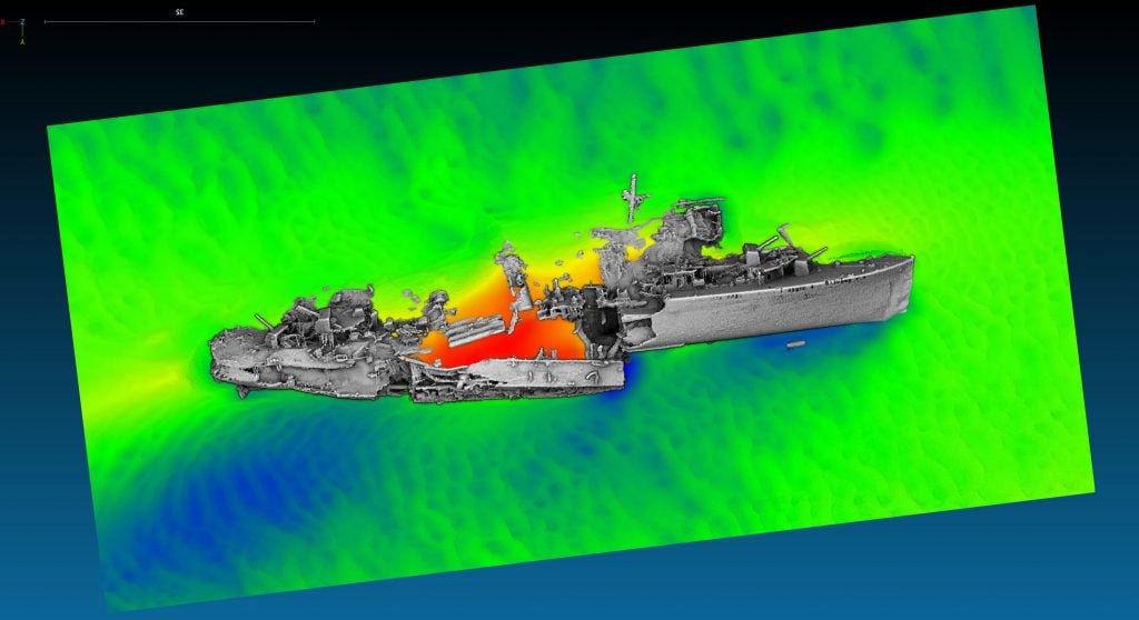
More than 80 years on from the desperate scramble of Allied troops across the Channel from Dunkirk, English and French researchers have surveyed 30 wrecks that were sunk during Operation Dynamo.
In a first collaboration between Drassm, France’s department for underwater archaeology, and Historic England, the team fixed a sonar scanner to the hull of a research vessel and trawled the waters off Dunkirk to survey the position, characteristic, and condition of each wreck.
“It’s very moving to see new details emerge from 30 shipwrecks linked to Operation Dynamo,” said Duncan Wilson, chief executive at Historic England. “The results give us a striking insight into our shared heritage that still lies beneath the waters off Dunkirk.”
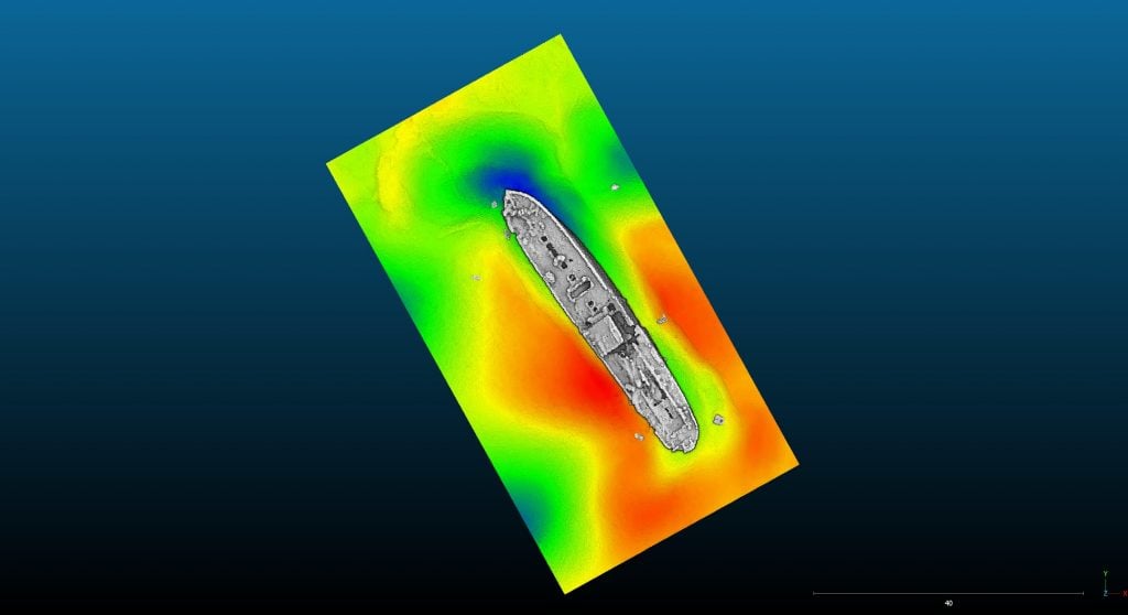
New multibeam survey of the wreck of the destroyer HMS Keith.
Image: courtesy A. Rochat (Drassm) and M. James (MSDS Marine/Historic England).
Sonar scanning works by sending out a fan of sound that is captured as it bounces off the seabed, thereby creating a three-dimensional image of what lies below.
To confirm the identity of the wrecks, the team worked off photographs and war records that recorded how and where vessels were sunk. Among the 30 wrecks, the location of 12 were previously unknown, and three were previously undiscovered.
For instance, on one wreck, the davits from which lifeboats were hanged could be seen and, together with the ship’s other details and dimensions, allowed researchers to conclude that it was the Normannia, a passenger vessel that was requisitioned to carry troops.
It was sunk by a Luftwaffe attack on May 30, 1940.
Though the majority of the wrecks remain in reasonably good condition, a further four wrecks could not be found, with researchers believing they have either been destroyed or covered over with sand.
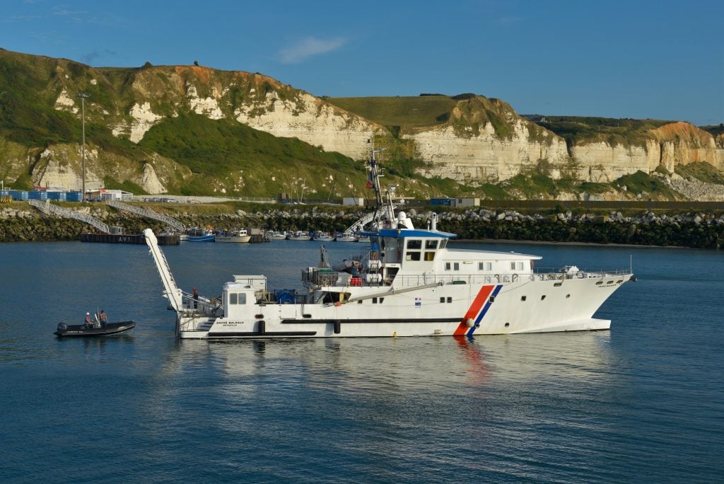
Drassm’s archaeological research vessel, Andre Malraux,
carried out the survey off Dunkirk to find lost ships during Operation Dynamo in 1940.
Image: courtesy CUD/Ville de Dunkerque.
It’s the first stage in a multi-year project, with Drassm planning to conduct a series of dives to further explore the wrecks in 2024.
Between 2015 and 2019, Drassm conducted a similar survey in Normandy to document D-Day landing beaches. An estimated 1,000 ships participated in the 1940 rescue of 338,000 Allied troops including 700 civilian vessels.
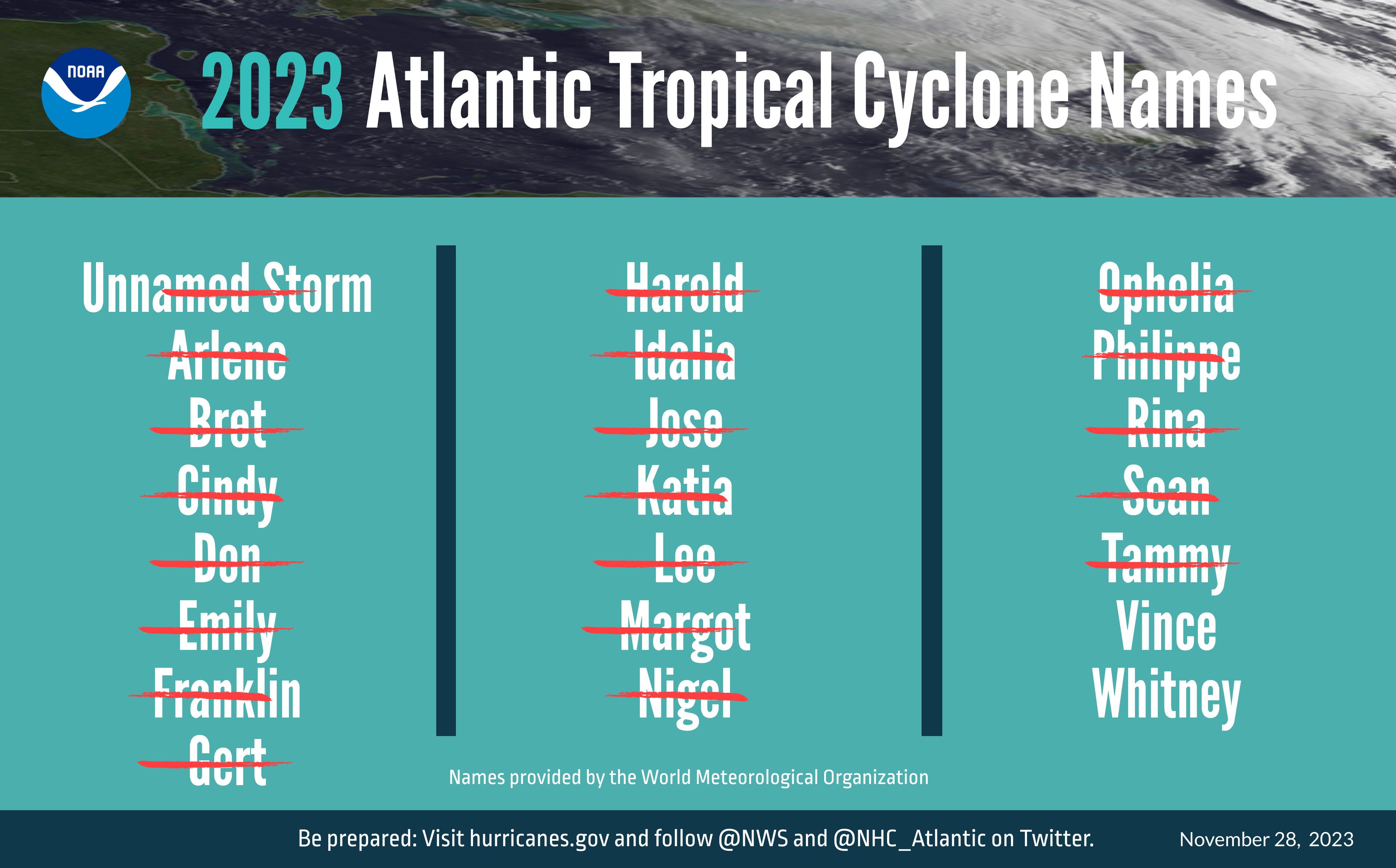
This season was very active in terms of the number of named storms, particularly those that formed earlier in the season.
The Atlantic basin saw 20 named storms in 2023, which ranks fourth for the most named storms in a season since 1950. Seven of these were hurricanes and three intensified to major hurricanes (Category 3 or higher on the Saffir-Simpson Hurricane Wind Scale).
An average season has 14 named storms, seven hurricanes and three major hurricanes.
Although the season runs from June 1 to Nov. 30, tropical and subtropical cyclone formation can occur at any time.
NOAA advances modeling and observation capabilities during the season
The above-normal 2023 Atlantic hurricane season, which officially ends on Nov. 30, was characterized by record-warm Atlantic sea surface temperatures and a strong El Nino.
The Atlantic basin saw 20 named storms in 2023, which ranks fourth for the most-named storms in a year since 1950.
Seven storms were hurricanes and three intensified to major hurricanes.
An average season has 14 named storms, seven hurricanes and three major hurricanes
The Atlantic basin saw 20 named storms in 2023, ranking 4th for most-named storms in a year. Tropical cyclone names are selected by the World Meteorological Organization.
(Image credit: NOAA)
Hurricane Idalia was the only U.S. landfalling hurricane in 2023.
It made landfall as a category-3 hurricane on Aug. 30 near Keaton Beach, Florida, causing storm surge inundation of 7 to 12 feet and widespread rainfall flooding in Florida and throughout the southeast.
Tropical Storm Ophelia made landfall as a strong tropical storm with 70 mph winds on Emerald Isle, North Carolina, on Sept. 23 causing widespread heavy rainfall, gusty winds and significant river and storm surge flooding in portions of eastern North Carolina.
Hurricane Lee made landfall as a post-tropical cyclone in Nova Scotia, Canada, on Sept. 16.
Swells generated by Lee caused dangerous surf and rip currents along the entire U.S. Atlantic coast.
Strong winds with hurricane‑force gusts from Lee caused extensive power outages in Maine and in parts of Canada.
“The Atlantic basin produced the most named storms of any El Nino influenced year in the modern record,” said Matthew Rosencrans, lead hurricane forecaster at NOAA’s Climate Prediction Center — a division of NOAA’s National Weather Service. “The record-warm ocean temperatures in the Atlantic provided a strong counterbalance to the traditional El Nino impacts.”
The eastern Pacific basin hurricane season was also above normal with 17 named storms, of which 10 were hurricanes and eight of those major hurricanes.
From Aug. 16 to 21, Tropical Storm Hilary brought widespread heavy rainfall and flooding to Southern California, with some areas receiving up to 600% of their normal August rainfall.
Hilary resulted in the first ever issuance of Tropical Storm Watches and Warnings for the Southern California coastline by NOAA’s National Hurricane Center. In addition, the Center distributed key hazard focused messages for Hilary in Spanish through the agency’s new language translation project.
Hurricane Otis made landfall near Acapulco, Mexico, on Oct. 25 as a category-5 hurricane with sustained winds of 165 mph.
Otis holds the record as the strongest landfalling hurricane in the eastern Pacific after undergoing rapid intensification in which wind speeds increased by 115 mph in 24 hours.
The central Pacific basin had a near-normal season with four tropical systems traversing the basin. Hurricane Dora, a category-4 storm, passed south of Hawaii in early August, marking the first major hurricane in the central Pacific basin since 2020.
The strong gradient between a high pressure system to the north and Dora to the south was a contributing factor to the wind-driven, fast-moving wildfires in Hawaii.
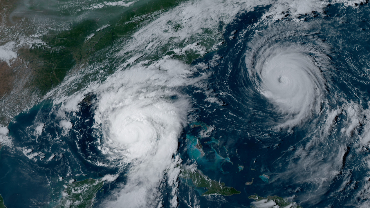
NOAA's
GOES-16 satellite captured Hurricane Idalia approaching the western
coast of Florida while Hurricane Franklin churned in the Atlantic Ocean
at 5:01 p.m. EDT on August 29, 2023.
“Another active hurricane season comes to a close where hazards from the storms extended well inland from the landfall location,” said NOAA National Hurricane Center Director Michael Brennan, Ph.D. “This underscores the importance of having a plan to stay safe whether you're at the coast or inland.”
NOAA’s new Hurricane Analysis and Forecast System helped National Hurricane Center forecasters improve intensity predictions this season. NOAA’s intensity forecasts showed Hurricane Idalia as a major hurricane impacting the coast of Florida as early as Aug. 28.
This lead time gave those in threatened areas more time to prepare and respond, and there were no storm surge fatalities from Idalia despite storm surge inundation of as much as 12 feet above ground level in some areas.
Further, extending the National Hurricane Center’s tropical weather outlook product from five to seven days, this season provided emergency managers more time to prepare and stage resources before a storm.
NOAA’s hurricane research and response
This season, NOAA Hurricane Hunter aircraft flew 468 mission hours to collect atmospheric data that is critical to hurricane forecasting and research, passing through the eye of a hurricane 120 times and deploying over 1,400 scientific instruments.
Since 2020 through this 2023 season, NOAA’s two Lockheed WP-3D Orion have flown 40% more hurricane mission flights than the preceding four years (2016-2019).
NOAA celebrated the first operational launch of a Black Swift drone from a NOAA WP-3D Orion to gather atmospheric data in and around Hurricane Tammy.
Further, the first successful coordination of a low-flying drone (Anduril’s Altius 600), atmospheric profilers (dropsondes), and ocean profilers (bathythermographs) also launched from a NOAA WP-3D Orion. Observations and information from these deployments are being evaluated to determine the feasibility of using the data to help with hurricane forecasting in the future.
NOAA’s Beechcraft King Air flew 28 mission hours to collect aerial imagery used for emergency response after Hurricanes Idalia and Lee.
Following Hurricane Idalia, NOAA's National Ocean Service provided support to enable safe maritime navigation, gathering survey data for 36.8 linear nautical miles and identifying 29 potential obstructions along Florida’s coastal waterways.
NOAA also worked to identify hazards caused by capsized vessels, damaged docks and piers, parts of homes and other types of marine debris, and shared findings with Florida's debris task force following Hurricane Idalia.
NOAA’s geostationary and polar-orbiting weather satellites provided vital information for monitoring and forecasting the hurricanes and tropical weather that threatened our lives and property this season. Forecasters used one-minute geostationary satellite imagery to assess structure changes during the rapid intensity of storms such as Idalia, Lee and Otis.
NOAA’s polar-orbiting satellites orbit the Earth from pole to pole 14 times a day, providing full global coverage twice daily.
Throughout the hurricane season, these satellites made sophisticated and precise observations of the atmosphere, ocean and land, which were critical to developing daily and 3-5 day forecasts.
The National Hurricane Center and Central Pacific Hurricane Center Tropical Cyclone Reports for 2023, including synoptic history, meteorological statistics, casualties and damages, and the post-analysis best track, will be published on the 2023 Tropical Cyclone Report site in March 2024.
NOAA’s Climate Prediction Center, a division of the National Weather Service, will issue its 2024 hurricane seasonal outlook in May 2024. The hurricane season officially begins on June 1.


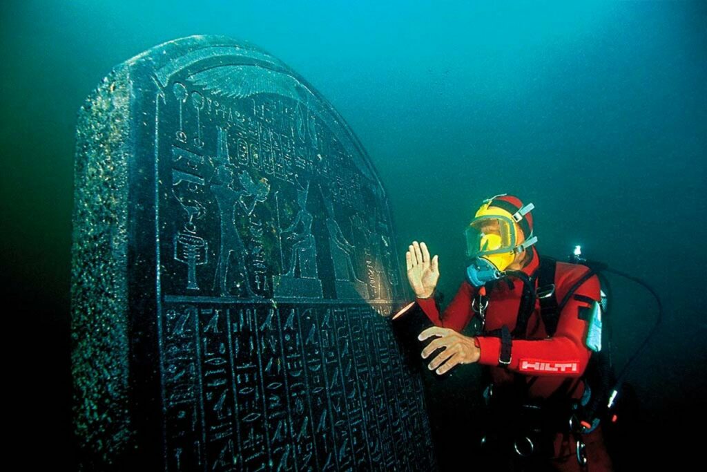 Franck Goddio examines the stele of Thonis-Heracleion erected on site under water in the city of Thonis-Heracleion, Abukir Bay. ©Franck Goddio/Hilti Foundation, photo: Christoph Gerigk
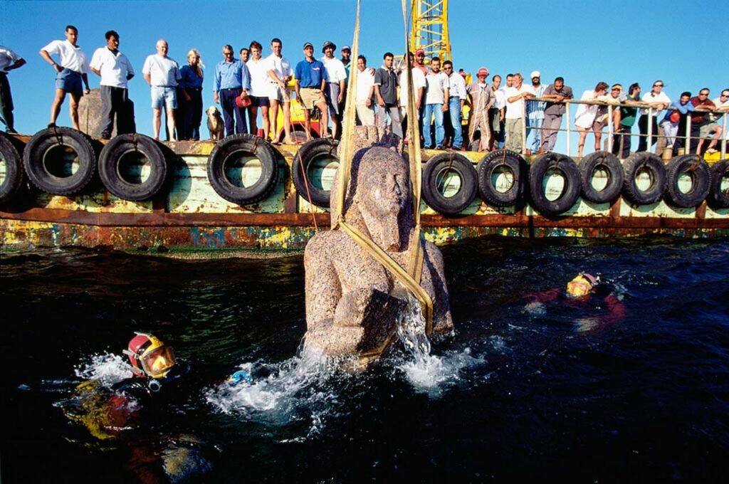 Franck Goddio and his team watch as a colossal statue representing the god Hapy, is pulled to the surface. ©Franck Goddio/Hilti Foundation, photo: Christoph Gerigk


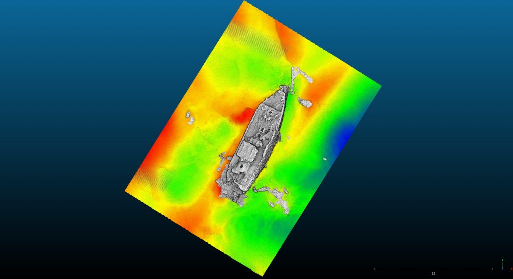
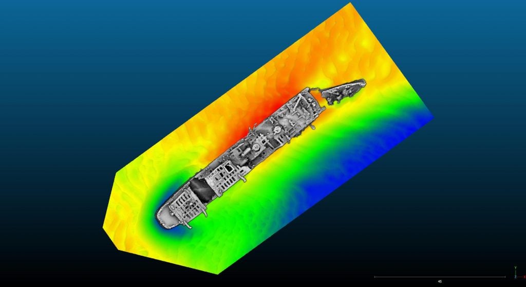 Multibeam survey of the wreck of the Normannia.