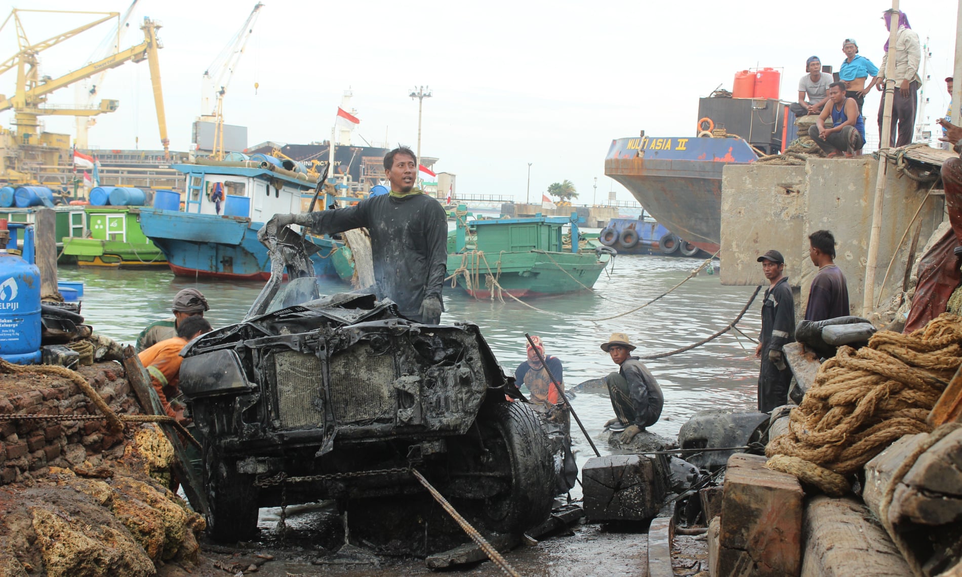
Saturday, June 3, 2023

Visualizing the human impact on the ocean economy

From VisualCapitalist by Iman Gosh   

When you think of economic output, it’s likely the ocean isn’t the first entity that comes to mind.
But from facilitating international trade to regulating the climate, the “blue economy” contributes significant value in both tangible and intangible ways.

The sustainable use of the ocean and its resources for economic development and livelihoods have such far-reaching effects, that its protection is a significant goal of the United Nations, as well as for many other countries and organizations throughout the world.

However, these vital ocean assets are in danger of sinking quickly.
We look at the total value of assets that come from our ocean, and how various human activities are affecting these resources.
 
Global Ocean Asset Value

Economic value from all the oceans is measured both by their direct output, as well as any indirect impacts they produce.

According to the World Wildlife Fund, these combined assets are valued at over $24 trillion.
Here’s how they break down:
  • Direct Output: Marine fisheries, coral reefs, seagrass, and mangroves
    • Total value: $6.9T
    • Examples of direct output: Fishing, agriculture
  • Trade and Transport: Shipping lanes
    • Total value: $5.2T
  • Adjacent Assets: Productive coastline, carbon absorption
    • Total value: $7.8T, and $4.3T respectively
    • Examples of services enabled: Tourism, education/conservation (such as jobs created)
In fact, the annual gross marine product of the oceans is comparable to the Gross Domestic Product (GDP) of countries, coming in at $2.5 trillion per year—making it the world’s eighth largest economy in country terms.

Unfortunately, experts warn that various human activities are endangering these ocean assets and their reliant ecosystems.
 
The Cumulative Human Impact on Oceans

An 11-year long scientific study tracked the global effect of multiple human activities across diverse marine environments.
The researchers identified four main categories of stressors between 2003-2013.
  • Climate change: Sea surface temperature, ocean acidification, and sea level rise
  • Ocean: Shipping
  • Land-based: Nutrient pollution, organic chemical pollution, direct human pollution, light pollution
  • Fishing: Commercial and artisanal fishing, including trawling methods
Across the board, climate stressors were the most dominant drivers of change in a majority of marine environments.
Similarly, pollution levels have also increased for many ecosystems.

Plastic pollution is especially damaging, as it continues to grow at u
nprecedented rates, with a significant amount ending up in the oceans.
The World Economic Forum estimates that by 2050, there could be more plastic in the ocean than fish by weight.

Among the various marine environments, coral reefs, seagrasses, and mangroves proved to be most at-risk, experiencing the fastest increase in cumulative human impact.
However, these are also the same ecosystems that we rely on for their direct economic output.

Overall, climate-induced declines in ocean health could cost the global economy $428 billion annually by 2050.
 
The Ocean Economy is in Hot Water

It can be difficult to truly understand the scale at which we rely on the ocean for climate regulation.
The ocean is a major “carbon sink”, absorbing nearly 30% of the carbon emitted by human activity.
But acidity levels and rising sea surface temperatures are changing its chemistry, and reducing its ability to dissolve CO₂.

According to the UN, ocean acidification has grown by 26% since pre-industrial times.
At our current rates, it could rise to 100-150% by the end of the century.
Overfishing is another urgent threat that shows no signs of slowing down, with sustainable fish stocks declining from 90% to 66.9% in just over 40 years.

To try and counteract these issues, this year’s virtual World Oceans Day is focused on “Innovation for a Sustainable Oceans” to discuss various solutions, including how the private sector can work with communities to maintain the blue economy.
In addition, there’s a petition in place to urge world leaders to help protect 30% of the natural world by 2030.

Will our human activities continue to stress the ocean economy, or will we be able to positively reverse these trends in the years to come?

Friday, June 2, 2023

Why don't hurricanes form at the equator?

An digitally enhanced satellite view of hurricane Dorian from 2019.
But why don't Dorian and other hurricanes form at the equator?
(Image credit: Roberto Machado Noa via Getty Images)

From LiveSciences by Charles Q. Choi

Here's why hurricanes, also known as tropical cyclones and typhoons, don't form at the equator and why it would be rare for them to cross it.(opens in new tab)


The fierce winds of a hurricane are known as tropical cyclones in some parts of the world, so you might expect them to sweep across the entire tropics.
But there's one area of the tropics where hurricanes almost never form: the equator.

Historical maps of the locations of tropical cyclones (also known as typhoons and hurricanes, depending on the location) would reveal that "it is extremely rare for them to form within a few degrees of the equator," Gary Barnes(opens in new tab), a meteorologist who's now retired from the University of Hawaii, told Live Science.
(One degree of latitude covers about 69 miles, or 111 kilometers.)

But why aren't there hurricanes at the equator?


This graphic shows the Coriolis effect, or how Earth's rotation influences the winds' direction north and south of the equator.
(Image credit: Shutterstock)
 
The reason is linked to why tropical cyclones rotate, which is due to Earth's spin.
At the equator, even when the air is calm, the planet and the atmosphere above it are actually moving at over 1,000 mph (1,600 km/h), Barnes said.
This movement follows Earth's direction of spin from west to east.

Earth's circumference is largest at the equator.
This means anything standing on the equator is moving faster eastward than anything lying away from the equator — anything on the equator is traveling a greater distance than anything north or south on Earth's surface in the same amount of time.

If air moves north from the equator, it will also still flow quickly eastward compared with its new surroundings.
This means air traveling north from the equator will appear to veer right.
In contrast, air flowing south from the equator will appear to stray left.

This phenomenon, known as the Coriolis effect, helps control the direction in which tropical cyclones spin.
In the Northern Hemisphere, rightward-turning air will create a counterclockwise spinning motion, and the opposite will occur in the Southern Hemisphere.

"Hurricanes collect rotation from the environment around them," Paul Roundy(opens in new tab), an atmospheric scientist at the University of Albany in New York, told Live Science.

This apparent turning of the wind "is very weak near the equator but becomes much stronger as latitude increases," Barnes said.
This is why tropical cyclones only rarely form near the equator — higher latitudes have faster-spinning winds to help drive tropical cyclone growth.

In December 2021, Tropical Cyclone Vamei occurred just 93 miles (150 kilometers) north of the equator, making it the closest hurricane to the equator since record keeping began.
(Image credit: Image courtesy NASA/JPL QuikSCAT science team)


Still, "there are odd exceptions," Barnes noted.
For instance, in 2001 the South China Sea, Tropical Cyclone Vamei "intensified within 2 degrees of the equator, but the nascent circulation actually formed earlier, farther away from the equator," he said.
Scientists think winds interacting with island terrain in the Indonesian archipelago may have generated the rotation that gave rise to Vamei, he said.

If a tropical cyclone were to cross the equator, "it would begin ingesting air rotating in the opposite direction," Roundy said.
Barnes noted that this would likely drive the storm to weaken and collapse.

However, "it's conceivable that a storm could cross the equator some small distance, since the opposing rotation remains fairly small close to the equator," Roundy said.
"It is probably not possible for a tropical cyclone to cross several degrees of latitude into the opposite hemisphere."

Climate change "does not significantly affect the rotation of the Earth, so it won't directly impact the chances of a hurricane crossing the equator," Roundy noted.
"However, if rare storms at low latitude were able to achieve higher intensities, if they happened to move toward the equatorial region, they might better maintain there.
Climate change might increase the strength of the strongest storms."

Links :

Thursday, June 1, 2023

Imray nautical raster charts layers update in the GeoGraage platform


Lost bones, a mass grave and war wrecks plundered off Indonesia


From The Guardian by Kate Lamb

Indonesian scrap metal workers tell of finding and discarding body parts after second world war ships were wrenched from sea bed

They knew about the bones: the arm and leg bones, the occasional skull, a few teeth still jutting out.

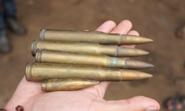
As the welders cut through the mangled steel of the old ships that had been brought their way, they came across the human remains mixed in with sea-rusted bullets, the odd pistol, rifles, helmets and jumbo-sized boots.

Muhammad Usman was one of those working at the welders’ yard in Brondong port in East Java when he says he smelled something.

He killed the flame of his torch to take a closer look and there, obscured by a piece of twisted metal, and lacquered in mud, was a charred human leg bone.

“I could smell something different, very unusual,” recalls Usman, his eyes widening, “I picked it up and wow, I could see that it was definitely a bone, so I gave it to the boss.”

The world’s biggest grave robbery

The source of the bones is not much of a mystery to the welders of Brondong.

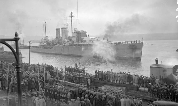
For more than six decades the wrecks of Allied warships, sunk in a crushing 1942 battle against the Japanese, lay undisturbed on the seabed not too many miles from Usman’s work place.

Dutch, British, Australian and American warships all went down in a naval campaign that led to the Japanese takeover of the then Dutch East Indies.

But in recent years, in what has been called the world’s biggest grave robbery, dozens of warships sunk in the waters of south-east Asia have been plundered en masse.

Data and analysis collected by naval historians and wreck divers who surveyed the sites found that at least 40 second world war-era vessels have completely or partially vanished – along with them the remains of up to 4,500 people.

In part the audacious theft was identified by a 2016 Dutch-funded expedition to mark the 75th anniversary of the Battle of the Java Sea.

Divers sent down to attach commemorative plaques found instead that two Dutch warships – HNLMS De Ruyter and HNLMS Java – had completely disappeared, while large parts of a third ship, HNLMS Kortenaer, were missing.

Among other discoveries, the expedition team found that three British warships, including two E-class destroyers, HMS Electra and HMS Encounter, and heavy cruiser HMS Exeter, had also been fully or partially removed.

 
Many of the old warships were at least 100 metres long, and some down as deep as 70 metres.

For years salvors had dived down to loot old wrecks, taking the most valuable bits and pieces, but in the past three years a more systematic and technologically sophisticated ransacking has been under way.

Operating mechanically and entirely from the surface are cargo barges equipped with cranes sporting giant metal claws that can plunge 200 metres deep, chomping up an old ship and pulling up several hundreds tonnes in one go.

As well as brass, copper, and bronze, one reason the salvaging has gone wholesale is the ships are a source of “low background steel” – produced before the first atomic bomb was detonated in 1945.
 
 
Virtually radiation-free, low-background steel is used in sensitive medical and scientific instruments. These old sunken warships are among the few remaining sources.

‘I only cut up the boats’


Depending from which side you view it, the discovery of the missing warships inspires either a deep sense of indignation, political awkwardness, or post-colonial indifference.

It is the latter that characterises the predominant feeling in Brondong, where the desecration of what are considered war graves barely raises an eyebrow.
“I only cut up the boats. That was my focus, on the work, not about whether there was a problem with the bones,” says Souudin, 47, when met by the Guardian at a small kiosk his wife runs at the port.

Souudin, who like many Indonesians uses one name, was a welder and subcontractor here from 2014 to 2016.

Each day, he says, about 50 workers would cut the steel from the old ships into blocks of up to a metre and a half, before it was sold at Rp200,000 [£10.50] per tonne and loaded on to the back of a truck.

“We often found the bones,” continues Souudin, as he takes a sip of grainy local coffee and a drag of his cigarette. 
“We worked here all the time, so we didn’t pay attention to them, whether there was bones or no bones, it made no difference to us.”


Of about half a dozen welders, all but one said they sometimes or often found bones in the old ships.

The welders get animated only when they mention how large the bones were – much bigger, they say, than Indonesian bones. 
 
Mostly they talk about them in a matter of fact way, noting the instructions were to give the bones to the boss, after which most don’t know what happened.

Port security guard Munahat, however, says he has a lead.
“The Chinese guy told Agus to do it,” recalls Munahat, referring to the company boss, and a welder named Agus. 
“We asked, ‘What’s that, Gus?’ They were bones, he said, and they were going to bury them … I heard he got about Rp100,000 (£5.25) to do that.”

The burial site is now a matter of public investigation. A team from the Indonesian foreign ministry and the Dutch embassy visited Brondong this week to exhume a site. The foreign ministry has declined to comment on this, or on speculation that some bones have been taken for forensic testing.

The mass grave
 

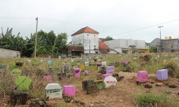
Suko cemetery, a few minutes’ drive from Brondong port, is a ramshackle plot in the middle of the village, overgrown with grass and densely dotted with small colourful headstones.

It is here that 70-year-old gravedigger Illyas believes some of the bones might be.

“There were plenty of human skeletons inside that ship. They gathered them, put them in a sack, and buried them here. I think there were four sacks,” he says, “Like the ones used to carry rice.”

Illyas has been working as the local gravedigger for about 55 years, but he admits that if there is a shallow mass grave here, he has only an approximate idea of where it might be.
“It’s west of the lamppost, in between the lamppost and that gate,” he says, gesturing to a space of about 10 by 10 metres.

It was at least two years ago when he heard that Agus, who has since left town, had buried the bones in the graveyard and also dumped some in a nearby rubbish heap.
 
Out of sight, out of mind

If the local mood around the bones is one of pragmatic nonchalance, further afield the disappearance of the vessels has caused outrage.
For the past year an irate Dutch government has been lobbying Indonesia in a series of joint meetings to try and determine how its celebrated war graves disappeared, while Britain has decried a breach of international law.

Responding to reports by Indonesian news website Tirto.id that some of the human remains from the ships had been dumped in a shallow mass grave, the British MP Luke Pollard called for urgent action to “ensure our fallen soldiers are buried with dignity and respect”.

The British foreign office confirmed that its concerns over the remains, which could include British soldiers and sailors, have been relayed in writing to the Indonesian government.
“We have asked the Indonesian authorities to investigate these claims and we stand ready to provide assistance if it is required,” a spokesperson told the Guardian.

But the public response so far has been somewhat anaemic, perhaps because the Battle of the Java Sea was one of Britain’s smaller, less widely known naval engagements.


The losses for the Dutch were also far greater. 
As well as ultimately its sprawling colony, the 1942 battle cost them 900 sailors, while the British suffered fewer than 200 fatalities.

Or says British naval historian Phil Weir, it could be that the desecration of a war grave far away and for decades hidden underwater elicits a muted reaction.
“You can imagine the massive outrage if someone drove a bulldozer through the big first world war Commonwealth war grave at Saint Symphorien,” he says, referring to a military cemetery in Belgium. “But taking apart a shipwreck doesn’t seem to have the same effect. It is kind of out of sight, out of mind, I fear.”

Haunted spoons

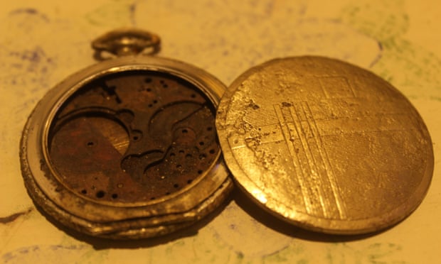
Back in Brondong there are many stories about the artefacts from the deep.

One local diver tells of how he blew off the top of his little finger when he brought home an old bullet and it exploded.
The finger on his right hand is now slightly shorter than the left.
Others say they are too scared to pillage after one diver developed an inexplicable limp after salvaging some “haunted” spoons.

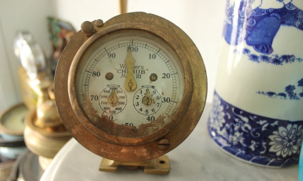
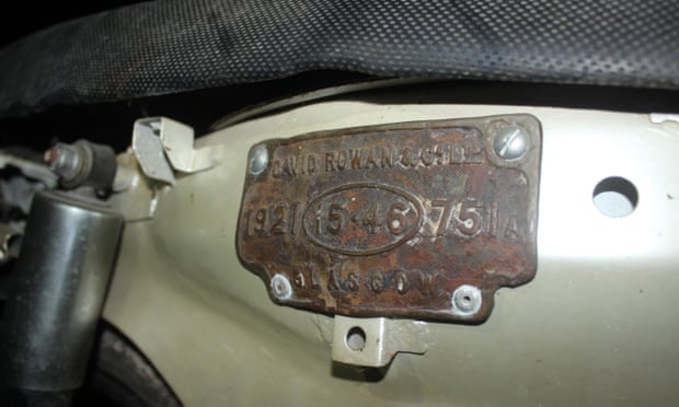
At least one of the welders with an eye for antiquities has pocketed a few of his finds.
His small collection includes a broken silver pocket watch, a bullet, a small terracotta-coloured bottle and several metal plaques, two of which were prised from an old engine and are now bolted to the sides of his Honda motorbike to give it a “vintage” edge.

Each piece is promising evidence, but none can be definitively tied to any of the warships. 
And with so much destroyed in retrieval, the chances of finding a piece that constitues a smoking gun are low.

Yet the welders are certain it was old warships they were cutting.
Besides the prevalence of weaponry, they also remarked on the old joinery techniques, fitted together through connecting parts, while the hull would sometimes be comprised of several layers of steel as though it was made “war-ready”.

The historian Phil Weir said the description could match the armoured plates on the bigger cruisers such as HMS Exeter that tended to “slotted together in a tongue and groove set-up” for reinforcement in battle.

Muslihan, another former subcontractor, estimated a salvage company that ran the operation could have “retrieved hundreds of ships so far” including cargo, trade and war vessels.

Government documents seen by the Guardian show a vessel was granted salvage permits in the Java Sea during the period the warships disappeared.
The company has not responded to questions from the Guardian.

Until a thorough investigation, the missing wrecks will remain a messy mystery, and one that gravedigger Illyas is keen to clear up.
The crudely buried, unsettled remains deserve a proper send-off, he says.

“I would like to retrieve them, make them coffins, and bury them somewhere proper,” says Illyas, surveying the crowded, sun-drenched cemetery. 
“Somewhere that people won’t bother them anymore. But I haven’t heard any feedback, so I’ve kept quiet on that.”

Links :

Wednesday, May 31, 2023

A boat went dark. Finding it could help save the world’s fish


From WP by Harry Stevens

On an early January afternoon, a South Korean fishing boat, the Oyang 77, departed from Montevideo, Uruguay, for the plentiful waters off the coast of Argentina.
A month later, it would be apprehended by the coast guard for illegal fishing.

As it intruded into Argentina’s territorial waters, the boat left a telltale digital signature, one that could be used to catch outlaw fishermen across the planet.

The Oyang 77 headed out to sea before turning southwest to track the Argentinian coast.
On Jan. 10, 2019, it turned off its location transponder and disappeared.
Over the next 17 days, the vessel disabled its transponder eight more times.
Its precise whereabouts during the gaps in its location data are unknown.
Finally, on Feb. 7, the Oyang 77 reappeared and made a beeline for Comodoro Rivadavia, Argentina.
It was escorted by the coast guard, under arrest for illegally fishing in Argentinian waters.
Commercial fishermen regularly disable their location transponders, sometimes for innocent reasons, but often to hide illegal activity.
Researchers and government officials say the gaps in transponder data can be used to track illegal fishing — and to fight back.


Today’s high seas are a bit like the Old West: a wilderness too vast to police, offering riches to those with a tolerance for danger and, sometimes, a dubious commitment to the law.

What’s at stake

It’s bad.
In part due to illegal fishing, more than one third of the world’s fishery stocks have fallen
 below biologically sustainable levels, threatening the more than 3 billion people who depend on seafood for animal protein and further imperiling maritime ecosystems already stressed by elevated levels of carbon dioxide.

It’s rampant.

Seafood is one of the last animal proteins that people hunt in large quantities.
Although farmed seafood has grown to more than half of global consumption, more than one hundred million tons are caught in the wild every year.
By one estimate, illegal and unreported fishing accounts for one-fifth of that total.

It’s on your store shelves.
As much as 11 percent of U.S. seafood imports came from illegal, unreported and unregulated fishing.

A stark reality confronts anyone who seeks to rein in bad behavior on the ocean: it is very, very big. 
To pinpoint where in the haystack to search for needles, a team of data scientists and machine learning engineers called Global Fishing Watch collects data from fishing boats’ Automatic Identification System (AIS) transponders, whose signals are picked up by satellites and land-based receivers.

Recently, the team at Global Fishing Watch had a novel idea: instead of looking for where fishing boats broadcast their positions, what if they looked for where they hid them? 
“The AIS data tells us a lot, but the absence of it does as well,” Tyler Clavelle, a data scientist at Global Fishing Watch, told me.

Together with scientists from the University of California at Santa Cruz and NOAA Fisheries, Global Fishing Watch analyzed more than 28 billion AIS signals from 2017 to 2019.
The researchers identified more than 55,000 gaps in the data and discovered that disabled transponders hide about 6 percent of the globe’s commercial fishing activity.

Fishing boats often hide their signals on the edge of Exclusive Economic Zone (EEZ) boundaries, where countries have the right to exploit the resources within 200 nautical miles off their shoreline.
That’s just what the Oyang 77 did in early 2019 when it vanished and reappeared near the boundary of Argentina’s EEZ.

The South Korean-flagged trawler belonged to the fleet operated by the Sajo Oyang corporation, notorious for its record of high seas transgressions, as documented by The Guardian. In recent years, the Oyang 77 had gotten in trouble in New Zealand for illegally dumping dead fish overboard, underreporting catch and failing to pay workers, according to a report from Oceana, a nonprofit focused on ocean conservancy.

In February 2019, the Argentine Coast Guard discovered the trawlerwith its nets extended inside the EEZ.
Leaving nothing to chance, they deployed a helicopter and an airplane to assist the Coast Guard in escorting the Oyang 77 to shore, releasing it after confiscating its fishing equipment and extracting a fine of 25 million Argentine pesos, or about $550,000.

Sajo Oyang did not respond to multiple requests to comment.

Global Fishing Watch’s data did not help catch the Oyang 77, but patrol boats from the U.S. Coast Guard and Canada’s Department of Fisheries and Oceans already make use of it to decide which boats to pursue.
Countries inspecting fishing boats in port can use Global Fishing Watch’s analytical tools to narrow their search.
“You can look up a vessel and see a history of its activity and quickly filter out vessels that appear to be operating above board, or identify vessels that have big gaps in their data or are operating in ways that are suspicious,” Clavelle said.

Using ships’ AIS data to enforce illegal fishing laws is not as easy as it sounds.
AIS is not universally mandated aboard commercial fishing boats.
Many fleets, including U.S. fishing boats, are tracked with a separate technology called the Vessel Monitoring System, which is visible to authorities but hidden from other vessels.

AIS was created in the 1990s as a way to keep oil tankers from crashing. In the 2000s, private companies began launching satellites that could capture AIS signals from space, and a new industry emerged to supply government agencies with ships’ location data. Yet even law-abiding fisherman sometimes wish to hide their location, either to conceal good fishing spots from competitors or to avoid capture in waters where pirates lurk.

“We thought we might have a pure illegal fishing story,” said Heather Welch, a NOAA affiliate and marine biologist at UC Santa Cruz, who led the research with Global Fishing Watch. 
“And it became very clear that that’s not fair to the fishermen, that that’s not the story we’re seeing here.”

The researchers used a method of machine learning to separate the innocent AIS disabling from the nefarious.
For instance, behavior that could have looked like statistical noise appeared to the researchers’ computer program as “loitering,” when boats with disabled transponders were motionless long enough to offload their catch to giant floating refrigerators called reefers.

This is not always illegal, but it can be a way for boats with illegal catch to get rid of the evidence.
“It’s a way to launder illegally caught seafood into the supply chain,” Welch told me. 
That makes it harder to know whether the fish at the grocery store was caught legally or not.
The analysis could help coast guards pinpoint where and when illegal transshipment is likely to take place.

Some in the fishing industry say that the rise of farmed seafood will reduce the opportunities for illegal fishing.
The share of seafood from aquaculture grew from 6 percent in 1960 to 58 percent today, according to figures from the U.N. Food and Agriculture Organization.

That share is likely to keep rising, said Gavin Gibbons, vice president of communications at the National Fisheries Institute, an industry lobby. 
“There’s only going to be more farmed going forward. Period. End of story,” Gibbons told me. “Farming will have to increase in order to feed a growing planet.”

Yet aquaculture has only kept pace with the growth in seafood consumption and has not replaced wild caught seafood.
Since the 1990s, wild seafood catch has stayed steady at about 100 million tons per year.


In short, fish farming has not lowered the pressure on wild marine life.
Even if aquaculture continues to grow, there will always be demand for wild caught fish, which many people prefer to the farmed variety.

If aquaculture is not the solution to overfishing on the high seas, perhaps technology is.
Global Fishing Watch and allies like Oceana, which co-founded the project in 2015, have pushed to require AIS on more commercial fishing boats.
Global Fishing Watch’s next goal is to learn to detect fishing boats directly from satellite imagery, which would reveal far more activity than AIS signals alone.
“What gets monitored gets managed,” Clavelle told me. 
“So if you can’t see what’s happening on the ocean, how do you expect to manage it properly?”

Links :


Tuesday, May 30, 2023

Deep sea reefs are spectacular and barely-explored – they must be conserved

Nekton, Author provided


From The Conversation by Paris Stefanoudis 

Sunlit coral reefs are perhaps the most famous marine habitat and many people will have snorkelled over or dived down to one at some point.
Home to a quarter of all known ocean life, these “rainforests of the ocean” have been at the forefront of marine research for decades and been featured in documentaries like Blue Planet and animations such as Finding Nemo.

However, reefs and corals do not stop where the sunlight becomes scarce.
Largely hidden from the masses lie great expanses of deep reefs, which collectively have a larger geographic footprint than their shallower counterparts.

Sandwiched between shallow reefs and the deep-sea, reefs between 30 and 300 metres to this day receive relatively little scientific attention, considered too deep for shallow-water reef biologists and too shallow for deep-sea researchers.
Combined with the costs and challenging logistics of studying them, and due to the widespread impression that they face few threats by simply being deep, despite evidence to the contrary, deep reefs remain notably underexplored. 
 

Reef zones in Bermuda with representative seafloor organisms.
As you go deeper, species change from light-dependent hard corals to sponges and ‘octocorals’ (wire corals, sea fans, whip corals).

Luckily, recent advances have allowed us to learn more about these unique ecosystems.
Specialised scuba equipment, known as technical diving, can get you down to 150 metres, and remotely-operated or autonomous vehicles, or even small manned submersibles, can go even deeper.
As we go deeper and less light penetrates the water, hard corals and other light-dependent organisms that dominate the shallows become less abundant.
They’re replaced by other photosynthetic groups such as fleshy algae, until they too get replaced by sponges, soft corals and sea fans.

I have had the privilege of being inside a submersible a dozen times now, in which an acrylic hull gives you an almost 360 degree view of underwater life.
The feeling is unique as you get to visit the depths of our ocean and observe its creatures – stuff you typically only see in documentaries – firsthand.
Massive sea fans are a particularly amazing sight, often more than 2 metres across:
 

The author goes sea fan spotting in the Maldives.
Nekton, Author provided


I have had several encounters with reef sharks, floating tube-like pyrosomes and bioluminescent comb-jellies, but the interactions I most enjoy are with the ever-curious potato groupers that will follow and hang around the submersible and even pose for photographs:
 

‘Fish whisperer’ Robert Carmichael of Global Sub Dive charms a grouper in the Seychelles. 
Nekton, Author provided

Fish are more mobile than corals or sponges and so the fish species at at the topmost deep reefs are still mostly-familiar.
However as you go deeper the fish gradually become more and more unique and adapted to the low-light, low-food conditions of deep reefs.

Notably, it is only a few years since scientists first described and categorised a new reef zone – the rariphotic or rare-light zone between around 150 metres and 300 metres in depth.
The unique collection of seabed organisms and fish helped define this depth range as an entirely new reef ecosystem.
Since we are only beginning to scratch the surface of deep reefs, many more exciting discoveries will follow in the coming years.
Deep reefs need targeted conservation

Deep reefs provide a plethora of essential services for people and the planet.
They help protect coasts from waves and storms, they provide breeding grounds and protection for fish, and refuge for some organisms residing in much-imperilled shallow reefs.
Natural medicinal products have also been discovered in deep reef species, including anti-tumor and anti-fungal compounds found in sponges collected from 125 metres deep in the Pacific island nation Palau.
 
Why deep reefs are worth saving.Nekton, Author provided


The logistical and financial challenges of studying deep reefs means there is less data available than for shallow reefs, and deep reefs are rarely used to inform management and conservation activities.
Though their unique biological communities warrant targeted conservation efforts, most deep and offshore reef habitats are still unprotected.
The few that are protected are often included incidentally due to geopolitical boundaries and rarely explicitly included in management plans and designation targets.

How we can save deep reefs

I’m part of a team of 18 scientists from different organisations around the world who have recently developed a framework for conserving deep reefs in the Western Indian Ocean, home to some of the world’s least known deep reefs.
Our framework includes practical recommendations, which we hope will enhance deep-reef stewardship throughout the region and could eventually be adopted globally.

Below are the our top five recommendations:
  • Protect: Highly protect 30% of ecosystems by 2030 (“30 by 30”), and include deep reefs in this target.
  • Conserve: Conserve deep reef ecosystems and their resources by specifically including them in fishery regulations, marine protected areas and marine spatial planning.
  • Manage: Extend current management efforts on shallow reefs to include deep reefs as these ecosystems are often connected.
  • Invest: Invest in foundational, fundamental and applied research on deep reef biodiversity, ecosystem functioning and provided services.
  • Collaborate: Develop national and international collaborations to survey and conserve deep reefs in national and international (High Seas) waters.
Links :

Sunday, May 28, 2023

Te Rehutai - Sailing at 50 Knots


With the blink of an eye, two months sailing Te Rehutai in Auckland has gone in a flash.
It may not seem like much- but the testing and development benefits has far exceeded the expectations for EmiratesTeamNZ.
But now, it is time for the great migration of Te Rehutai for a long northern summer ahead getting used to the unique characteristics of the waters to Barcelona.