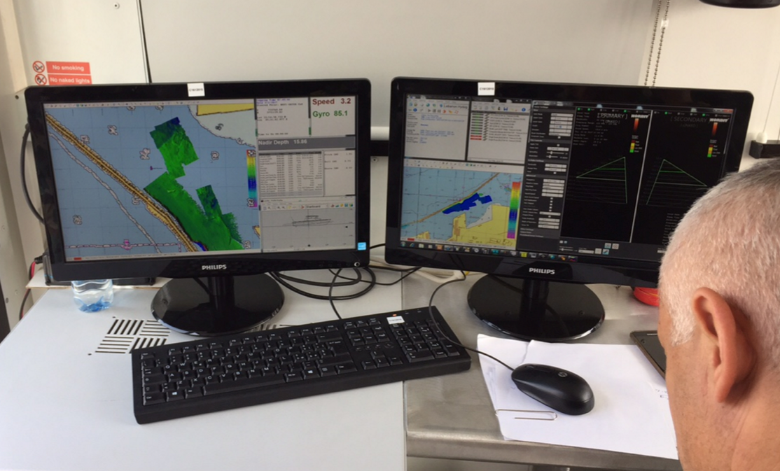
We are pleased to present this amazing video realised with Fledermaus, the interactive 4D geo-spatial processing and analysis software designed QPS.
The video, characterised by a stunning quality, portrays three wrecks and part of the Beirut harbour structure, until today unknown and now mapped for the first time.
In March 2017, Lighthouse together with QPS, organised a training for the Lebanese Navy in cooperation with the Italian Navy as part of the ISG (International Support Group Lebanon) program.
Beirut harbor with 4 identified wrecks with the GeoGarage platform (SHOM chart)
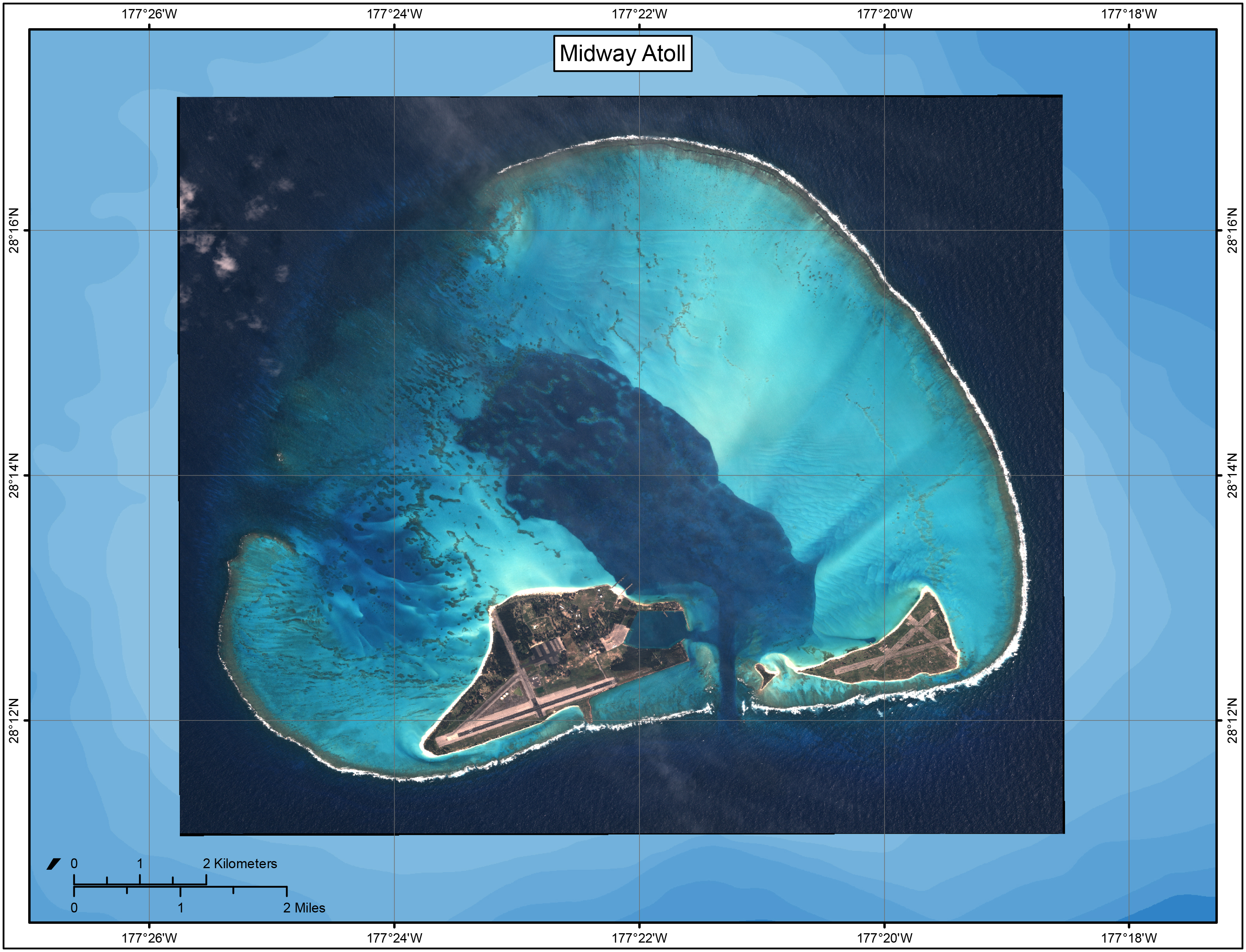
The Battle of Midway was fought from June 3–7, 1942, at and around the island of Midway in the central Pacific Ocean.
Today, it is considered to be the decisive battle of the war in the Pacific.
Over the next few days, we will mark the 75th anniversary of the battle.
The battle resulted in the loss of four Japanese aircraft carriers and their accompanying aircraft and crew, accounting for two-thirds of Japan’s fleet carrier force.
Despite sinking the American aircraft carrier USS Yorktown during the battle, the Japanese Navy’s severe losses would never be fully replaced, forcing them to fight a strategic defense for the rest of the war.
While the primary carrier fleet engagement occurred to the north of Midway Atoll, much of the secondary action originated from the atoll itself.
Midway is a tiny, remote atoll which was, 75 years ago, one of the most strategically important few square miles of land in the world.
On September 2, 1945, the Japanese officially surrendered to end WWII.
An aerial view of Midway Atoll.
Image courtesy of Papahānaumokuākea Marine National Monument/NOAA.
Today, the U.S. Fish and Wildlife Service administers Midway Atoll as a National Wildlife Refuge. The refuge lies within Papahānaumokuākea Marine National Monument, a marine protected area encompassing all of the Northwestern Hawaiian Islands.
In 2000, the Secretary of the Interior designated Midway Atoll National Wildlife Refuge as the Battle of Midway National Memorial.
This was the first national memorial designated on a National Wildlife Refuge, reminding us of the heroic courage and sacrifice of those who fought against overwhelming odds to win an incredible victory.
Midway atoll with the GeoGarage platform (NOAA raster chart)
Within Papahānaumokuākea Marine National Monument, Midway Atoll is known as Pihemanu, which is a Hawaiian word for loud din of birds, and Kuaihelani, which is a Hawaiian word meaning back bone of heaven.
The Monument’s intrinsic cultural and natural heritage value assured its place as a World Heritage Site.
2016 marked the 10th anniversary of the establishment of the monument, the 5th anniversary of its World Heritage inscription, and on August 26, 2016, President Barack Obama expanded the monument to become one of the world’s largest marine conservation areas.
Whether navigating an oil tanker, cruise ship, fishing vessel, sailboat, or any craft, the mariner requires a suite of navigation charts that are consistent and easy to use.
The public feedback we received to the National Charting Plan regarding the “sunset of paper” charts (p. 26) highlights two navigation products in particular, NOAA paper nautical charts and raster navigational chart (RNC).
We recognize the continued popularity and dependence of many of our users on our paper and raster charts, and NOAA will continue to update these charts with all critical information.
Despite some reports to the contrary, the draft plan does not offer a timeline for ending the production of NOAA paper charts or RNCs.
We expect this process may take decades to complete, as user communities continue to adopt electronic navigation and our production system and products continue to improve.
However, we do want to start the conversation and solicit feedback to focus our improvement on electronic navigational charts (ENC).
In response to a surge of interest in the past few weeks, although the official comment period ends June 1, 2017, as stated in the Federal Register Notice, we will continue to accept comments on the National Charting Plan through July 1, 2017.
Merrimack river with RNC charts with the GeoGarage platform (zoom)
(Google Maps JS API)
Merrimack river with ENC charts with the GeoGarage platform (zoom on existing coverage)
(ESRI ArcGIS JS API)
The ENC vector chart is still relatively new and needs some improvement.
We recognize that in many cases, the ENC is not as easy to use as its paper equivalent, even though it satisfies all requirements for safe navigation.
The long-term goal at NOAA is for ENCs and charts derived from them to surpass paper charts in all categories and for all mariners to prefer them to paper.
Merrimack river with RNC charts with the GeoGarage platform
(Google Maps JS API)
Merrimack river with ENC charts with the GeoGarage platform (existing coverage)
(ESRI ArcGIS JS API)
The Merrimack River (US5MA1AM) provides an example of how a new NOAA ENC® fulfilled a local request for larger scale data.
Historically, charts did not depict the river from Newburyport to Haverhill, MA, at an appropriate scale for recreational boaters to navigate safely.
NOAA created a robust 1:12,000 scale ENC (without corresponding large-scale paper and RNC charts) to allow recreational boaters to navigate safely on the river.
Full ENC of the Merrimack River at 1:12,000 scale
NOAA intends to increase its large-scale coverage in recreational areas but does not believe that it is always practical to offer corresponding traditional paper chart coverage.
Large-scale data across large areas is better suited for use in electronic navigation systems for both regulated and recreational mariners.
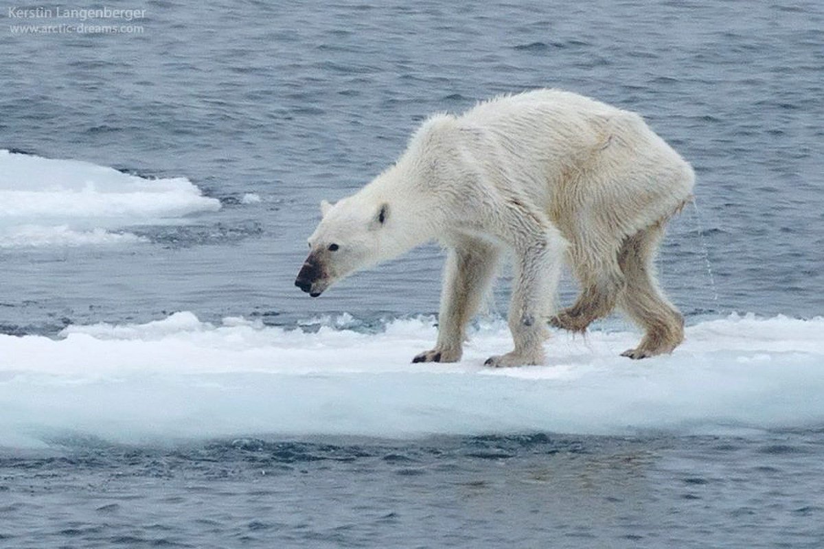
While President Donald Trump is keeping everyone in suspense, a White House official said Wednesday morning that Trump will formally withdraw the United States from the Paris climate change agreement.
Exiting the deal would make the United States one of the few countries on Earth to altogether dismiss the threat of climate change, and risks complicating already fraught relationships with European allies and rising powers like China and India.
Politico walks through some of the questions and answers that led to Trump’s decision.
What is the Paris climate deal?
In 2015, representatives of 195 nations met in Paris and agreed to take steps designed to keep global temperature increases below 3.6 degrees Fahrenheit to avoid potentially devastating consequences related to sea level rise or extreme weather.
Each government submitted its own voluntary pledge outlining steps to reduce its carbon footprint.
Then-President Barack Obama said the U.S.
would reduce its emissions by 2025 to about 27 percent below the level in 2005, identifying his domestic policies such as the Clean Power Plan and stricter automobile fuel-efficiency requirements as key contributors to that pledge.
Countries with less mature economies, such as China and India, pledged that their emissions would eventually level off after rising for several more years — an arrangement Trump and other critics of the agreement said made it a “bad deal” for the U.S.
But supporters of the Paris agreement point out that it is not legally binding and that the Trump administration cannot be forced to continue implementing Obama’s policies.
Trump has repeatedly dismissed human-caused climate change as a “bulls---” “hoax” invented by the Chinese to undercut U.S. manufacturing, and those who urged him to exit virtually all believe that scientists’ warnings of more extreme weather and rising seas are overblown.
Trump also has said that U.S.coal, oil and manufacturing companies are disadvantaged by efforts to reduce carbon emissions.
While the question of what to do about Paris deeply divided the Trump administration, the president appears to have sided with nationalists who portrayed the agreement as antithetical to his “America First” agenda.
“It was an America second, third, or fourth kind of approach.
China and India had no obligations under the agreement until 2030.
We front-loaded all of our costs,” Environmental Protection Agency Administrator Scott Pruitt has said of the deal.
Trump’s exit from the climate accord puts the United States alongside Syria, which is embroiled in a civil war, as the only nation on Earth that does not view climate change as a policy problem.
(Nicaragua, the only other country not on board with the Paris deal, is staying out because it does not believe the deal does enough to address climate change.)
What happens now?
It's unclear.
Trump has several options he can use to withdraw the U.S.
from the deal, and the White House has not yet detailed his plans ahead of a formal announcement the president says is still several days away.
Trump may decide to treat the Paris deal as a treaty and submit it for a Senate ratification vote, which would surely fail, or he could go through a formal withdrawal process envisioned in the agreement itself, though that would take several years.
Trump also could exit the previously ratified 1992 treaty that established the underlying climate negotiations that produced the treaty, but even Republican senators who said Trump should pull out of Paris did not say he should exit the broader United Nations Framework Convention on Climate Change.
AP photo
Does this mean EPA will no longer regulate greenhouse gas emissions?
Not exactly.
The Trump administration is already in the process of rescinding or revising Obama’s climate change rules such as the Clean Power Plan, but that has nothing to do with whether the U.S.
remains a part of the Paris accord.
The bigger question for Pruitt is whether he is able to undermine EPA’s scientific conclusion that heat-trapping gasses like carbon dioxide are a danger to the public and must be regulated by the Clean Air Act.
So far, Pruitt has been reluctant to reverse that so-called endangerment finding, which has been upheld by the Supreme Court since EPA published it in 2009.
Legal experts say that means Pruitt will eventually have to write new rules limiting carbon emissions from power plants and other major sources, although Pruitt has not yet announced his next steps.
Will this save the coal industry?
Doubtful.
The biggest problem coal faced is electric utilities switching power plants to run on cheap natural gas unleashed by the U.S. fracking revolution.
In the past decade, coal has fallen from more than 50 percent of the U.S. electricity market in 2000 to around 30 percent today, and market analysts say that share is likely to keep falling.
In fact, the largest U.S. coal companies urged Trump to stick with the Paris deal, in an effort to secure more backing for technologies like carbon capture and sequestration that they believe are vital to the industry’s long-term future.
Still, leaders of some smaller mining firms, such as Murray Energy CEO Bob Murray, urged Trump to pull out of Paris, saying it was an “illegal” waste of taxpayer money.
Who supports this decision?
Pruitt was perhaps the most vocal member of Trump’s administration in favor of withdrawing from the agreement, arguing behind the scenes that sticking with the deal would complicate his efforts to unwind Obama’s climate change regulations at EPA.
A group of Republican senators, including Majority Leader Mitch McConnell of Kentucky and Senate Environment and Public Works Chairman John Barrasso of Wyoming, echoed that argument last week in an influential letter to Trump, saying that the accord could provide ammunition for environmentalists to use in lawsuits challenging Trump’s energy agenda.
Other supporters of leaving the deal included White House chief strategist Steve Bannon, a handful of smaller energy companies, and conservative groups such as the Competitive Enterprise Institute and American Energy Alliance.
And 56 percent of Republicans wanted Trump to exit the deal, according to a poll last month from Politici and the Harvard T.H. Chan School of Public Health.
Official trailer for An Inconvenient Sequel (Al Gore 2017)
Truth to Power, the sequel to An Inconvenient Truth.
Who opposed it?
Trump’s daughter Ivanka and son-in-law Jared Kushner have been among those urging him to stick with the deal, along with Secretary of State Rex Tillerson and several Republican members of Congress, including Senate Energy Chairman Lisa Murkowski of Alaska.
They said staying with the nonbinding deal would not inhibit Trump’s broader energy goals but allow the U.S. to maintain influence in international climate change negotiations and related diplomatic efforts.
Major U.S. and global energy companies, including ExxonMobil, the top three U.S. coal producers and major tech companies like Apple and Google also sought to persuade Trump to remain in the Paris deal.
About 62 percent of Americans overall supported staying in the accord, including more than six in 10 independents and 87 percent of Democrats, according to the Politico-Harvard poll.
What does this mean for the planet?
It’s not good, but prospects weren’t exactly rosy before Trump made up his mind.
The emissions-reduction policies Obama put in place were insufficient to hit his U.S.
target in the Paris deal even if they had been fully implemented — and Trump has already put virtually all of them on the chopping block, making any reductions more difficult to achieve.
And many scientists say the climate accord’s goals are too modest to limit global temperature increases to 3.6 degrees, and that to do so, global carbon emissions will have to reach net zero by the end of the century, a herculean task.
Any major new emissions-cutting policies will come from states like California and New York or foreign leaders in Europe and China, and activists will keep pressure on oil and coal companies to reduce their carbon footprint.
Just a few hours after news of Trump’s decision broke this morning, Exxon shareholders voted in favor of a resolution asking the company to report annually on how it is dealing with climate change.
Lockheed Martin successfully launches Vector Hawk, a small, unmanned aerial vehicle (UAV), on command from the Marlin MK2 autonomous underwater vehicle (AUV) during a cross-domain command and control event hosted by the U.S. Navy.
This effort marks a milestone in showing that an unmanned aircraft, surface vessel and undersea vehicle can communicate and complete a mission cooperatively and completely autonomously.
The question of how to launch drones over the ocean has been a lingering technical problem as the U.S. military has scaled up its interest in unmanned system.
But Lockheed Martin just launched a small aerial drone out over the ocean through another drone, showing the possibilities of cross-domain drone launches.
The Marlin MK2 autonomous underwater vehicle, shown here at an event sponsored by the U.S. Navy, was able to launch a Vector Hawk, a small aerial drone, from the surface of the Narragansett Bay in Rhode Island.
"This signifies the versatility of Lockheed Martin's unmanned systems to communicate seamlessly across domains to conduct a diverse set of missions in all environments. The capability is quickly reconfigured in the field," says Kevin Schlosser, chief architect of unmanned systems at Lockheed, in a press release.
"In a short time, we enabled these systems to work together by rapidly changing sensor packages."
In addition to Marlin and Vector Hawk, the Submaran, an unmanned
surface vehicle (USV) developed by Ocean Aero, provided surface
reconnaissance and surveillance.
A Vector Hawk can fly for more than 70 minutes, Lockheed says, and operators only need a few minutes to recover and re-launch one, including time taken to change batteries.
The government has been trying out multiple approaches to its problem of launching drones from the middle of the ocean, including a robotic arm that would catch them.
The floor of the Gulf of Mexico is one of the most geologically interesting stretches of the Earth’s surface.
The gulf’s peculiar history gave rise to a landscape riddled with domes, pockmarks, canyons, faults, and channels — all revealed in more detail than ever before by a new 1.4 billion-pixel map.
projection : Mercator / datum : WGS84 blue : 0-25m / green : 30-100m / yellow : 120-150m / orange : 150-200m / red : 200-260m
This striking view of the ocean floor off the coasts of Louisiana and Texas was created by a government agency you’ve likely never heard of called the Bureau of Ocean Energy Management (BOEM).
The bureau’s job is to manage exploration and development of the country’s offshore mineral and energy resources.
Consequently it has access to all the survey data that private companies collect.
The exploration companies use 3-D seismic imaging to map areas of the Gulf they are interested in.
This involves towing high-powered underwater air guns behind a ship.
When the guns fire, they create sound waves that travel down and are reflected back up by the sea floor.
Lines of underwater microphones pulled along the surface behind the ship record how long it takes the reflected waves to reach them, data that can then be translated into topography.
As you can clearly see in the image below, this data is much higher resolution than the best available map, which was made in the 1990s.
The feature known as Horseshoe Basin in the western Gulf of Mexico shows up far more clearly on the new high-resolution map (right).
Horseshoe Basin view with the GeoGarage platform (NOAA chart)
The strange geology of the floor of the Gulf is mostly caused by thick underlying layers of salt.
Scientists think the salt probably accumulated around the time when Africa was just starting to separate from the Americas around 200 million years ago.
At that point, the Gulf was probably a separate basin that was filled with seawater that later evaporated, leaving a blanket of salt behind.
Later, as the basin became a gulf, the salt was covered with sediment deposited by rivers.
Because salt doesn’t compact under the weight of overlying layers like sediment does, it ends up being less dense than the sediment above it.
Because salt also flows easily, it can deform and get squeezed, which results in blobs of salt pushing up into the layers above, making domes and ridges and faults.
These strange, complex configurations are part of the geology that created the conditions that allowed vast oil deposits to collect.
Only a vague outline of this bizarre landscape was visible on the old map, which had a resolution of 27,000 square feet per pixel, actually quite good for the seafloor.
But it wasn’t good enough for biologists who needed a more detailed picture of the area around the 2010 Deepwater Horizon oil spill so they could assess the ecological damage.
In response to their call for help, the BOEM devised a way to make a high-resolution map by combining the data from several 3-D seismic surveys that exploration companies had done in the area.
With that success, they realized they could map the whole Gulf of Mexico the same way.
The Joshua Channel (labeled channel-levee) in the eastern Gulf of Mexico stands out clearly on the new high-resolution map of the sea floor.
Joshua Channel view with the GeoGarage platform (NOAA chart)
They took all the best survey data from more than 200 individual maps made by exploration companies of parts of the Gulf and combined them into a map of the whole region with resolution of around 1,600 square feet per pixel — about the size of the average American family home.
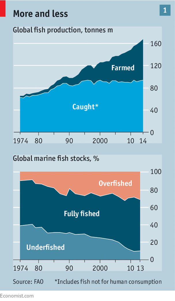
Across the world fish stocks are in decline. 90% of all commercial stocks are now overexploited or fully exploited and the pressure from the fishing industry is increasing.
West Africa is facing a crisis, fish stocks are in free fall.
The livelihood of generations to come will depend on the fish of these oceans.
The oceans face dire threats. Better regulated fisheries would help
EVEN the names at Sutton Harbour give it away.
While the pleasure boats, including Windfall and Felicity, gleam in the sunshine, the light warms rust on the decks of craft such as Pisces.
The fishing industry is struggling to stay afloat in Plymouth, a port in Devon.
Locals grumble about regulation, fuel costs and the dearth of crew.
Revenues are stagnant and the facilities ageing.
But if times are tough for the fishers, they may be tougher for the fish.
The world currently consumes more fish per person than ever before—about 20 kilos a year.
But almost all the recent gains in production have been down to farmed fish.
Aquaculture has grown remarkably in the past decades, especially in China; in 2014 it accounted for half of all the fish people ate.
But that does not mean that the pressure on the open seas has eased.
In 2013, the most recent year for which full data are available, 32% of the world’s fish stocks were being exploited beyond their sustainable limit, up from 10% in the 1970s, according to the UN’s Food and Agriculture Organisation.
The amount of fish caught at sea has been pretty much flat for the past three decades, but the share of the world’s fish stocks that are being plundered unsustainably has continued to increase (see chart 1).
Overfishing is not the only problem.
Pollution, notably fertiliser run-off, damages a lot of marine ecosystems.
There are estimated to be 5trn bits of plastic in the ocean, with over 8m tonnes of the stuff added every year.
By the middle of the century the sea could contain more plastic than fish by weight, according to research done for the Ellen MacArthur Foundation.
Not all the harm comes directly from the land; some comes via the sky.
Carbon dioxide accumulating in the atmosphere has so far raised the world’s average sea-surface temperature by about 0.7ºC.
This has effects at depth; when seas warm up they become more stratified, making it harder for nutrients in the waters below to rise to where they are most needed by fish and plankton.
Given this, it might seem fortunate that the ocean absorbs a fair bit of that carbon dioxide, thus reducing the warming.
But doing so changes the ocean’s chemistry, making it more acidic.
This is a particular problem for creatures with calcium-carbonate shells—which includes not just crabs and oysters but quite a lot of larvae, too.
Acidification makes carbonates more likely to dissolve.
It is hard to grasp the scale of such planetary changes, and impossible to say how much damage they will do.
That is the way of things with the ocean; it is vast and human horizons are close.
That something so immense could be put at risk just by people leading their daily lives seems inconceivable.
But as with the atmosphere and the surface of the continents—where humans now move more sediments than the natural processes of erosion—the fact that something is vast does not mean humans cannot have profound impacts on it.
For the sake of the hundreds of millions of people who depend on the ocean for livelihoods or sustenance, as well as for the sake of the ocean itself, these human impacts need to be reined in.
There are signs that, where fishing is concerned, this may be coming about, not least because monitoring what goes on over the horizon is becoming ever easier.
But there is a great deal left to do.
April 2017.
Greenpeace and Guinean Fishery authorities CNCP conduct surveillance and inspect illegal fishing activities.
Losing Nemo
Overfishing is bad for fish; it is also, in the long run, bad for those seeking to catch them.
The goal of sound management is to have a stock that is harvested at the same rate that it replenishes itself—which might typically be a stock about half the size of what would be there if there were no fishing at all.
If fishers take more than this “maximum sustainable yield”—as they do in many fisheries today—then in the long run they will get less out of the resource than they could, quite possibly imperilling its future.
If stocks were allowed to rise back up far enough for the world’s fisheries to reach their maximum sustainable yield, the industry would increase production by 16.5m tonnes—about a fifth of the current total—and bring in an extra $32bn a year.
Good management could in principle get the stocks back up through the use of quotas, property rights and other constraints on untrammelled exploitation.
Quotas and similar controls have worked well in some cases.
In American waters 16% of stocks were overfished in 2015, down from 25% in 2000.
But they have drawbacks.
Because they want to land the largest fish they can find, fishers throw back undersized specimens, which often die as a result.
And because fish mix, species caught by accident are thrown back if a fisher has no quota for them.
Quotas are also often badly set.
Regulators and politicians pander too much to powerful fishing interests, according to Rainer Froese of the Helmholtz Centre for Ocean Research in Kiel, Germany.
Lobbies, which often benefit from the importance of fishing to specific places, push for short-term profit over long-term sustainability.
“They harvest the apples by cutting the tree branches,” says Mr Froese.
The problem is exacerbated by a lack of evidence, which makes overly permissive quota-setting easier.
More investment in research and monitoring could help.
But in developing countries, where the need is often dire, there are frequently no resources to meet that need, and in many rich countries fishing is not a big enough industry to make such research a national priority.
“We are not good value for the taxpayer, but how can you have an island nation without a fishing fleet?” asks Pete Bromley, a former fisherman who is now master of Sutton Harbour.
Aquaculture boosters might answer that fleets are simply no longer needed.
But farmed fish, particularly salmon and their ilk, are fed on smaller fish that themselves are caught at sea.
Insects or algae might provide alternative fodder, but the companies involved are slow to embrace such novelties, according to Ari Jadwin of AquaSelect, which provides advice to Chinese fish farms.
One issue, he says, is that Chinese consumers are not moved by sustainability arguments.
But he thinks that concerns over food safety will lead to better practices in the long run.
Those struggling to make money from early mornings in stormy seas worry more about business in the next year than in the next fifty.
“Climate change isn’t happening next month.
At the moment we’ve got to hang on to what we’ve got,” says Mr Bromley.
But worrying trends are already visible.
As equatorial seas warm up, many plankton species are extending their range towards the poles by hundreds of kilometres a decade; where they lead, fish will follow.
Moving somewhere cooler might seem a simple thing; but temperature is not all that matters to fish, and so there can be trade-offs involved.
The flounders off the coast of Britain like water that is both relatively shallow and fairly cool, says Martin Genner from the University of Bristol.
With water temperatures around the south of the country 1.5ºC higher than they used to be, the flounders have headed north—but there the waters are deeper, which suits them less well.
Fish may also need particular types of food at particular times in their life cycles, such as when their larvae hatch.
If predators and prey respond to warming by heading to different places, or by speeding up or slowing down their breeding at different paces, such needs will go unmet.
But how much, and where, food webs will be thus disrupted is hard to say.
Few of the models seeking to predict how climate change will affect fish consider ecological interactions between species.
Greenpeace and fishing authorities of Sierra Leone doing joint surveillance and inspect illegal fishing activities.
Fixed assets
Not everything in the sea can move to waters new with the flick of a fin.
Coral reefs, for example, are rather stuck.
Although they cover less than a thousandth of the world’s sea floors, they support a quarter of known marine species—and through them millions of people who rely on fishing and tourism for their livelihoods.
As oceans warm, corals risk “bleaching”—losing their colourful algal symbionts—because the algae involved can only survive in a slim range of temperatures.
Without their algae, which photosynthesise, the corals lose their source of energy.
There have been three global bleaching episodes since 1998, worsened by El Niño events that heat up the tropical Pacific.
The one that started in 2014, and is still going on, has been the longest and most damaging; more than 70% of the world’s coral reefs have been harmed by it.
Australia’s Great Barrier Reef, worth $4.6bn each year to nearby Queensland alone, has been particularly badly affected.
“Five or ten years ago, most of the discussion about coral reefs was over how they would look by the end of century,” says Rusty Brainard, a coral expert at America’s National Oceanic and Atmospheric Administration.
“Now the talk is of whether coral reefs will survive as we know them to 2050 or even 2030.”
Acidification makes the picture worse.
Though it is hard to distinguish the effects of chemistry from the other problems that beset reefs, it seems a fair bet that an environment where calcium carbonate is more likely to dissolve will not be good for them.
A study published last year by researchers at the Carnegie Institution for Science made the point clearly by running de-acidified water over a reef; the corals perked up nicely.
Doing the same for all the world’s reefs, though, is hardly an option.
Faced with chronic problems and hard-to-quantify future crises, the sea’s resources need to be looked after better by all those—countries, consumers, companies and fishers—with a stake in their survival.
Much of that needs to be done in national jurisdictions.
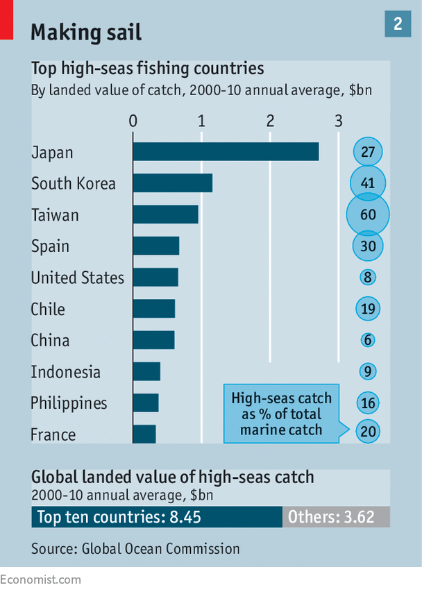
Though overfishing means that many fleets now head farther from home than before, about 90% of the catch is from the “exclusive economic zones” (EEZs) that countries are entitled to claim out to as far as 200 nautical miles (370km) from their shores.
What counts as a shore, and a claim, though, can be disputed: China’s assertion of fishing rights in the South China Sea, which contains a tenth of the global fish catch, sets its neighbours on edge (though it is hardly the only thing that does).
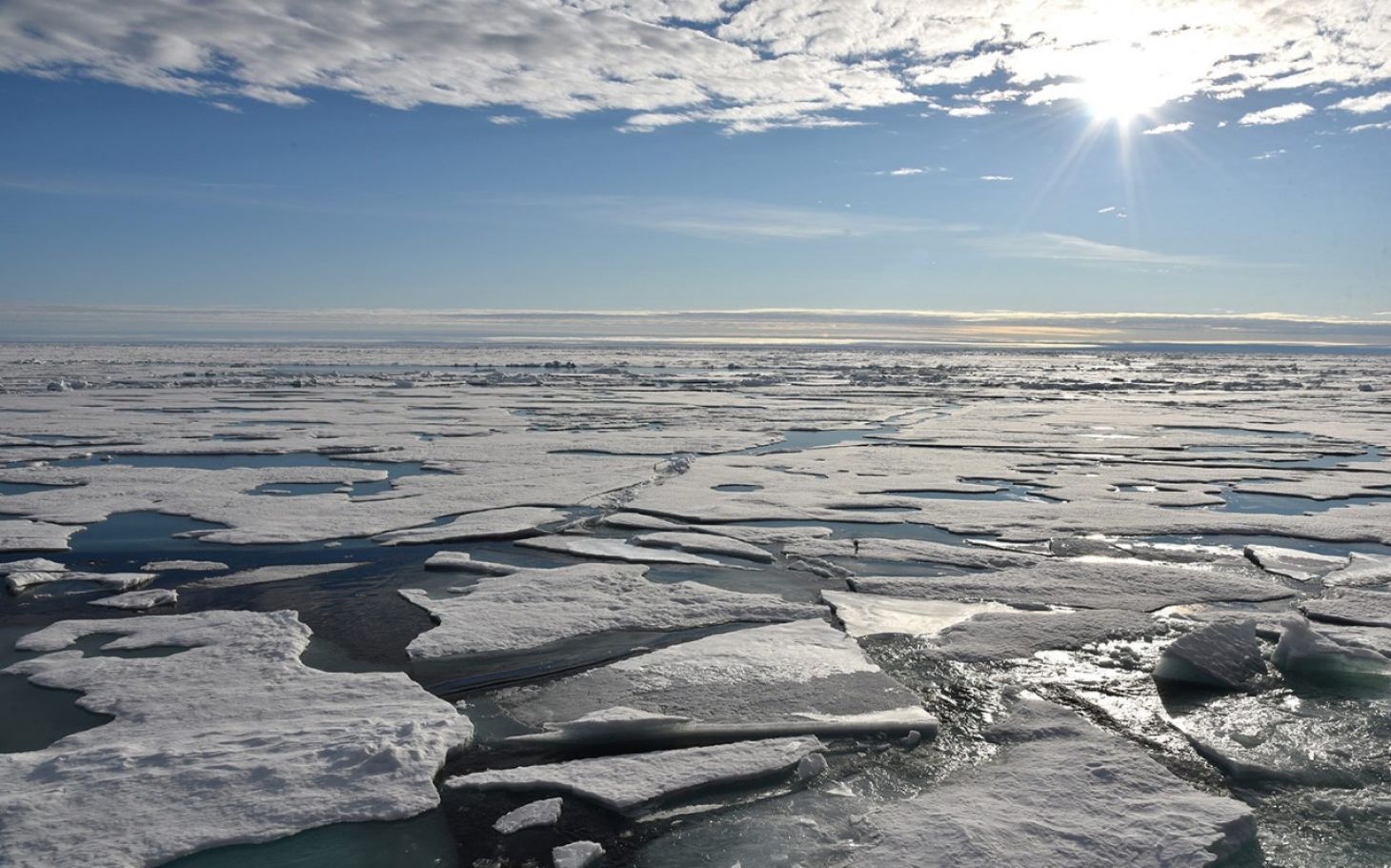
Russia, America and other Arctic states argue over new access to fish stocks in the melting north.
Though what goes on in EEZs is largely a sovereign matter, there are some levers available to outsiders.
The World Trade Organisation (WTO) hopes to introduce new rules on fishing subsidies at its next ministerial jamboree in December.
These come to $30bn a year, with seven in every ten dollars handed out by comfortably-off countries.
The WTO first started discussions on fishing subsidies back in 2001; Pascal Lamy, formerly its director-general, says a great deal of effort has gone into working out which subsidies are contributing to harmful fishing practices.
The reckoning now is about 60% of them do so.
China, which gets far more fish from its EEZ than any other country does from theirs (as well as fishing, by agreement, the EEZs of other countries), seems open to action on subsidies if some unrelated anti-dumping measures are loosened.
But how to bring poor countries on board remains a thorny issue.
Although coastal African states want change, many inland ones fret over the higher cost of fish.
“The whole point is to make fish more expensive,” explains Mr Lamy, “so as to internalise the cost of environmental depletion.” Sensible stewardship, but not necessarily an easy sell in countries where fish from elsewhere are a cheap source of protein for the poor.
Establishing more protected areas both within EEZs and on the high seas beyond would be another way to help, particularly if they were to contain “no-take” zones where fishing is completely barred.
Such zones provide breathing spaces, or breeding spaces, in which stocks can recover.
Crow White from California Polytechnic State University and Christopher Costello from the University of California, Santa Barbara have calculated that if such an approach was taken to its extreme and the high seas were closed to fishing, then yields elsewhere could rise by 30%, with fisheries’ profits doubling because fish closer to shore become cheaper to catch.
The countries that dominate fishing in international waters (see chart 2) would never stomach such a ban; they prefer the often inadequate regulation offered by regional fisheries-management organisations.
But even in these regimes, temporary and rolling closures have been tested.
In the Antarctic permanent ones have proved successful.
Spotting boats that misbehave on the high seas (or indeed in EEZs) is getting easier.
The International Maritime Organisation (IMO) requires ships over 300 tonnes to have an Automatic Identification System (AIS), a radio transmitter which tells anyone in the vicinity the boat’s position, speed and identity so as to avoid collisions.
“In the vicinity”, though, now includes “up above”; various satellites can use AIS transmissions to track ships.
Spire, an American startup, is building up a constellation of tiny spacecraft with which it hopes to log 10m AIS transmissions every day by the end of this year.
Global Fishing Watch, an online platform created by Google, Oceana, a marine charity, and Sky Truth, which uses satellite data to further environmental causes, is a keen user of AIS transmissions.
They do not just let it locate fishing vessels; they let it take a good guess as to what they are doing (boats long-lining for tuna, for example, zigzag distinctively).
The platform currently follows 60,000 vessels responsible for 50-60% of the world’s catch, according to Brian Sullivan from Google.
Indonesia is planning to use the platform to make public data that it gathers through “vessel monitoring systems”—information which can reveal more about what is actually happening on-board than AIS location data do, and as a result is often jealously guarded.
The more other countries follow suit, the better the picture will be.
The Port State Measures Agreement, which came into force in 2016, means that if such monitoring leads a country to suspect that a foreign vessel is doing something dodgy, it does not have to go out and inspect it in order to take action.
The agreement’s clever construction means that poor countries without much by way of navy or coastguard can deny a suspicious foreign vessel entry to their ports and pass its details on to other countries that might have the wherewithal to check it out.
Over $2 billion losses in West Africa from illegal fishing by international countries which is hurting the economies of these small countries in West Africa, Mauritania, Senegal, Cape Verde, Guinea, Guinea-Bissau, and Sierra Leone
Companies can act, as well as countries.
Food suppliers and retailers such as Costco, Sodexo and Walmart are trying to combat poor fishing practices through a body called the Seafood Task Force.
The idea is to ensure that supply chains are what they purport to be and that labour conditions in the industry are up to snuff with an eye to fixing problems before they become scandals.
And insurers are interested in the sort of monitoring Global Fishing Watch does: ships that turn their AIS off increase the risk of collisions; they may attract bigger premiums or have their policies revoked.
Investors currently have little information on how their choice of investment affects marine life.
Fish Tracker, a not-for-profit firm, aims to put that right.
It is looking at the risks posed by unsustainable fishing in the same way that climate activists have studied the risks of fossil-fuel investments in order to warn off investors.
Mark Campanale, the initiative’s founder, says that at the most basic level investors need to understand that if one boat catches one fish, ten boats will not catch ten.
To that end the outfit is analysing information covering 300 fishing companies with a market capitalisation of $530bn to calculate the unacknowledged downsides imposed by environmental limits.
None of this can drive change effectively, though, without the support of fishers.
Including them in the design of regulatory regimes can bolster scientific analysis and reduce political tensions; by bringing them into the process it also deepens their understanding of sustainable practice.
“It would be unacceptable for farmers to go through an educational system without understanding crop yields and the need to manage the land for future generations,” says Jim Masters of Fishing into the Future, a charity.
“But there are no equivalent opportunities for fishermen.”
For the sake of the fish, there should be.
Those that were there will recall that it was quite grey when the Gipsy Moth did finally berth at the then HQ of the Royal Western Yacht Club over at West Hoe, had it not been for the glare of the media lights it would have been difficult to pick up on what was happening.