“This is a story about conquering and overcoming your personal fears — in this case, the water,” director Alan Barillaro said in an exclusive interview with USA Today last week. “This is a tale of how to grow up in a world that seems so large and intimidating with the courage to get past those fears.”
The little sandpiper learns how to forage for food in the short clip and (we’re told by editors who have seen the film) Piper even makes a friend who shows her the ways of the ocean.
“There’s also the parent aspect, personal to me,” Barillaro told USA Today of the film. “Letting your kids grow up, make mistakes and not hovering over them. The mother piper is the parent I wish I was — being there for your kids, but giving them space to grow.”
We are now starting a long #livedive down to Endeavour, Canada's first Marine Protected Area.
It will take 2-3 hours to reach the hydrothermal vents on the ocean floor, depth 2200m.
The main purpose is to lay a cable from Mothra to RC-South (in yellow on map above).
This will bring online the RC South Junction Box, a BPR and 2 moorings.
Following a post-lay inspection, we will then install instrumentation at Mothra: a hydrophone, seismometer, BPR and BARS.
see LIVE : www.oceannetworks.ca//expeditions/2016/research-vessel This is the main camera from the Jason ROV (Remotely Operated Vehicle) The R/V Sikuliaq is a 80 metre ice-capable oceanographic research vessel, equipped with the Woods Hole Oceanographic’s robotic vehicle Jason that can dive to 6500 metres. It hosts a team of 24 scientists and a ships crew of 22.
Endeavour and Neptune observatory on the GeoGarage platform (CHS chart)
The Endeavour area of the Juan de Fuca Ridge is a seismically active area of seafloor formation and hydrothermal venting.
The Endeavour Hydrothermal Vent area is located 250 km offshore from Vancouver Island, 2250 meters below the ocean’s surface. The map shows the locations of the five main hydrothermal vent fields and smaller sites of flow.
In the darkness of special places like the Endeavour Hydrothermal Vents, ocean research is bringing to light deep secrets about life on earth and potentially elsewhere in our universe.
“Black Smokers” and hydrothermal vents Create an ecologically-rich oasis in the deep
It’s not often scientists suggest they’ve found an entirely new group
of animals, something so different that they can’t be considered as
belonging to one of the main groups, such as shellfish, insects, worms,
jellyfish, sponges, animals with backbones (like us) and so on.
So there was a fair bit of excitement when researchers in reported, in 2014, on strange mushroom-shaped organisms living on the deep seafloor, a kilometre under the water surface, off south-eastern Australia.
These animals, called Dendrogramma, were certainly peculiar.
There was a gelatinous stalk and cap shaped like a mushroom, an opening
down the bottom of the stalk that looked like a mouth, and a canal that
ran from there up into the cap, radiating into numerous branches.
There
were no appendages or special cells that would give away its
relationship to other animals.
If that wasn’t intriguing enough, the creatures bore some resemblance to 560 million-year-old fossils that have been found in Newfoundland, Russia and Namibia, as well as in the Flinders Ranges in South Australia.
This is from a time when the first multi-celled organisms were
forming, back before animals and plants took on the shapes and functions
that we see today.
How amazing if these strange simple creatures had
survived off Australia for hundreds of millions of years!
Dendrogramma-like fossils from 560 million years ago.
But a crucial bit of evidence was missing from this story; there was no DNA data.
Just like in police investigations and medicine, DNA has proved
indispensable to the modern biologist.
It can reveal relationships
between organisms or plants that would not be guessed from their
appearance.
Organs such as eyes have evolved multiple times and do not necessarily indicate a shared ancestry.
But the Dendrogramma specimens had been collected in 1986 and preserved in DNA-busting formalin.
More examples had to be found first.
Alien-like mushroom-shaped creatures have been discovered in the depths of the ocean off the Australian coast.
Scientists said two species of the unusual life form were found that could not be placed in any existing group of organisms.
The animals, named Dendrogramma, consist mainly of an outer skin and inner stomach, separated by a dense layer of jelly-like material.
A discovery in the deep
And so the matter rested until November last year when the sharp eyes
of Hugh MacIntosh of Museum Victoria spotted the familiar mushroom
shapes at the bottom of a seafloor sample hauled it up from 2,800 metres
in the Great Australian Bight.
Hugh was on Australia’s new research vessel RV Investigator, participating in a CSIRO-led scientific program to study the marine environment off South Australia.
Hugh emailed us urgently from the ship: “Guess what I have found.”
Australia’s new research vessel, the RV Investigator.Tim O'Hara/Museum, Victoria
Science is often a waiting game.
So we had to wait for the RV
Investigator to finish her voyage, wait for the specimens to arrive,
wait until the DNA extraction and sequencing proceeded through various
laboratories, and then wait for publication.
Not that we were idle during that time.
Our evolution guru, Andrew
Hugall, downloaded genomes from dozens of animals, setting up a system
that could pigeonhole DNA-sequences originating from a single-celled
protozoan to a whale.
And still we waited; the Christmas break didn’t help.
We even set up a betting sweep, each of us guessing where Dendrogramma would be placed in the tree of life (I didn’t win).
Finally, at 4:30pm, one Tuesday afternoon in January, the DNA results
came in.
Andrew’s computer whirled and four hours later we had an
answer. Dendrogramma was a type of siphonophore.
The what’s-it-called?
A siphono-what?
Well, that was almost our reaction, because even to a
bunch of marine biologists, siphonophores are uncommon and strange
creatures.
They are cnidarians related to jellyfish, corals and anemones.
They
have polyps like corals, but have long stinging tentacles like jellyfish
and can move around.
Some polyps function as propulsion units, some are specialised to
feed, and yet others are gonads. They also can have flattened defensive
appendages called bracts.
These can also be mushroom-shaped!
The evidence shows that the Dendrogramma specimens are not entire animals, but just siphonophore bracts, pieces detached from a larger creature.
A benthic siphonophore attached by tentacles
to a ledge on the sides of a deep-sea canyon in the Gulf of Mexico.
Okeanos Explorer/NOAA
One mystery leads to another
Some commentators have criticised the original authors for publishing without DNA data.
I don’t fully agree with this view.
You need people to raise ideas
and hypotheses that can be tested against subsequent data.
We wouldn’t
have even looked for Dendrogramma if we had not been alerted.
DNA evidence indicates that the Dendrogramma mushrooms are not entire animals, just pieces of a siphonophore.What the whole animal looks like remains a mystery.David Paul and Rebecca McCauley/Museum Victoria
Okay, we were disappointed that Dendrogramma was not a
completely new type of animal.
But the hunt is important. Hundreds of
millions of years of independent evolution could have resulted in the
development of all sorts of biochemical novelties, from antibiotics to
cancer drugs.
So we have solved one part of the mystery but others remain.
We know what Dendrogramma bracts look like but not the whole animal.
Siphonophores come in a variety of shapes and sizes.
The deep sea is a big place.
It took decades for us to get video footage of the giant squid; it may take decades again for us to see footage of Dendrogramma in all its living glory.
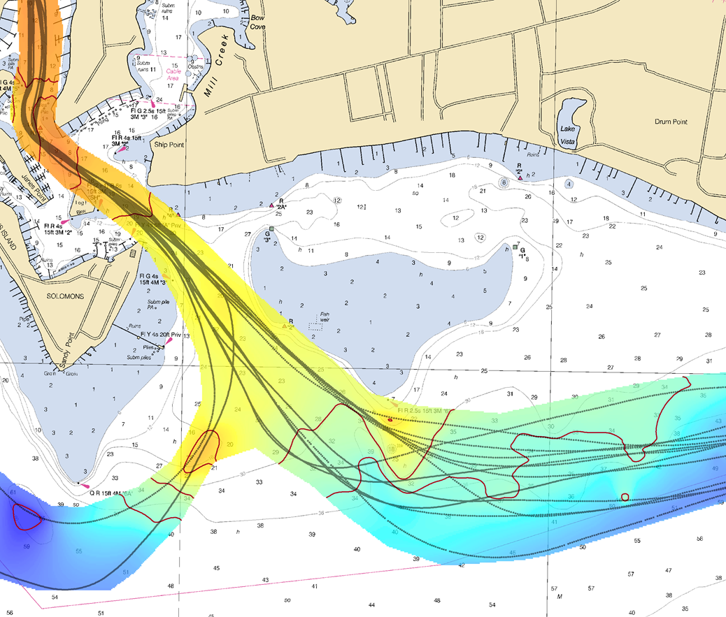
Coast Survey Research Vessel Bay Hydro II collected about
123,000 soundings, over 12 days, to pre-test the efficacy of Rose Point
beta test for bathymetric crowdsourcing.
From NOAA by Lt. Adam Reed, Integrated Oceans and Coastal Mapping (IOCM) Assistant Coordinator We are on the verge of acquiring a significant new source of data to improve NOAA nautical charts, thanks to an enthusiastic industry and mariners equipped with new technology.
The United States has about 3,400,000 square nautical miles of water within our coastal and Great Lakes jurisdiction.
Coast Survey, who is responsible for charting that vast area, averages about 3,000 square nautical miles of hydrographic surveying each year.
The data collected by those surveys update over a thousand NOAA charts.
However, hydrographic surveys are expensive and laborious, and so Coast Survey directs them toward the highest priority sites, which leaves many coastal areas without updates for many years.
Coast Survey may soon get new sources of information, provided voluntarily by mariners, which will alert cartographers to areas where shoaling and other changes to the seafloor have made the chart inaccurate.
Rose Point Navigation System beta tests new crowdsourcing database
Technology has reached the point where any boater can buy an echo sounder kit, add a GPS system, record depth measurements, and make their own geospatial observations in a common reference frame.
The question then for hydrographic offices (who are concerned with improving nautical charts for safe navigation) becomes “how do we take advantage of that?”
Rose Point Navigation Systems is working with system developers at NOAA’s National Centers for Environmental Information (NCEI) and with hydrographic experts at Coast Survey and others who are collaborating on an international effort to maintain crowdsourced bathymetry.
In a beta test released on May 13, 2016, Rose Point has added a new feature to Coastal Explorer that gives users an option to send anonymous GPS position and soundings data to a new international database managed by NCEI.
After getting permission from users, Rose Point systems will generate data log files of positions, depths, and time, and automatically transmit the files to the data center, where Coast Survey can pull the data to compare it to nautical charts.
Crowdsourced bathymetry is an international project
Using data from private sources is not new for Coast Survey.
Private interactive cruising guides and other internet-based enterprises have set up services that allow commercial mariners and recreational boaters to share information about navigation hazards they see (or experience) while on the water.
The United States Power Squadrons and the U.S. Coast Guard Auxiliary have a decades-long tradition of sharing updates through our cooperative charting programs.
But the lack of appropriate software and integration between sources has hampered efforts to use the information to its full potential.
Evaluation and Use of Crowd Source Bathymetry in SHOM’s Digital Bathymetric Models
Hydrographic offices around the world are re-thinking crowdsourced bathymetry.
In October 2014, Coast Survey led the U.S. delegation to the Fifth Extraordinary International Hydrographic Conference, with Rear Admiral Gerd Glang at the helm.
At this meeting, the U.S.and France jointly proposed an initiative (see Proposal No.4) that introduced crowdsourced bathymetry as a recognized source of data for nautical charts.
One of the results of that initiative was the formation of the IHO Crowdsourced Bathymetry Working Group (IHO CSBWG) that set out to develop crowdsourcing principles and guidelines, and then offer a platform for sharing best practices around the world.
Working hand-in-hand with NCEI, the working group has developed a database that can receive volunteered bathymetric data.
Data can come from anyone in the world, and everyone can access it.
Coast Survey will use crowdsourced bathymetry to assess chart accuracy
Crowdsourced reports serve an important role in focusing attention on trouble areas.
The data helps cartographers determine whether a charted area needs to be re-surveyed, or if they can make changes based on the information at hand.
Even with very sparse data, cartographers can make improvements to nautical charts.
Agreeing in principle to use crowdsourced data is much different than applying the system to the vigor of data transmission from moving vessels, however, so Coast Survey experts contributed hydrographic expertise and system testing.
Using Rose Point’s Coastal Explorer, Coast Survey Research Vessel Bay Hydro II transmitted “crowdsourced” data using log files that were automatically produced by the electronic charting system software.
(Bay Hydro II is Coast Survey’s primary platform to test and evaluate new hydrographic survey technologies.)
“When you aggregate crowdsourced data, we can expect to see trends
develop where the seafloor has likely changed from charted data,”
explains Lt. Anthony Klemm.
“Using Bay Hydro II data
transmissions, we saw such trends indicating shoaling near the Patuxent
river entrance. Similarly, in the approach to Solomons harbor, trends
displayed depths deeper than charted.”
It is important to emphasize that Coast Survey does not necessarily
make changes to any significant charted feature based on crowdsourced
data alone.
That data, however, is about to become a major factor in
making charts better.
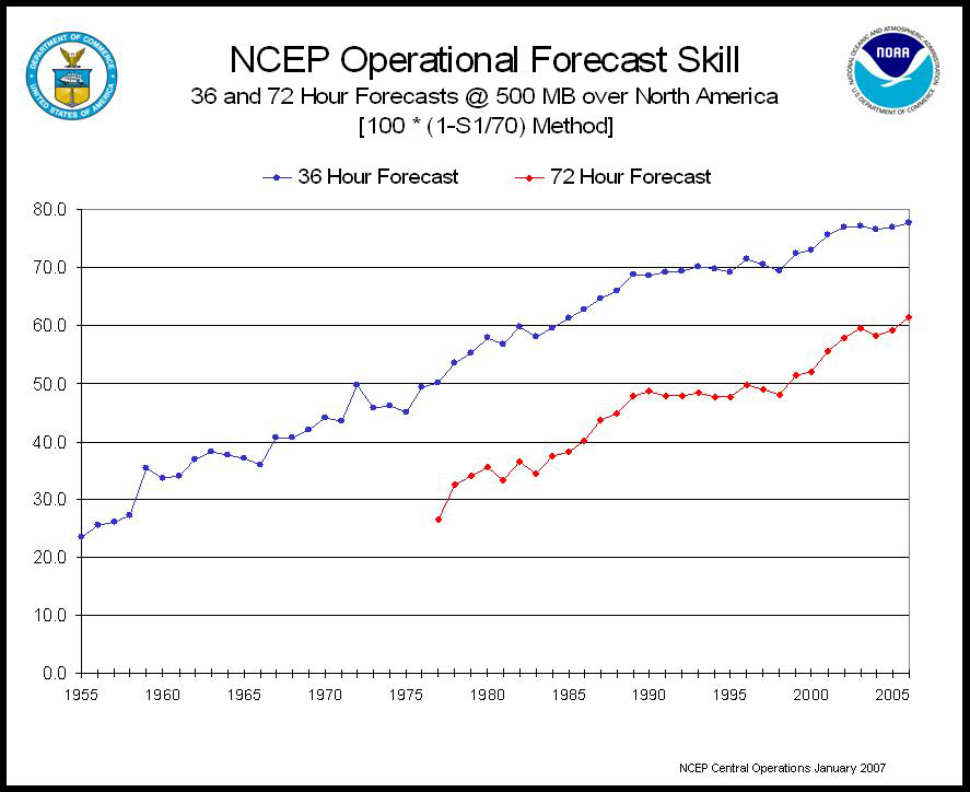
This graph shows computer power and time versus model accuracy as
defined by the S1 score (a measure of the skill of the forecast) of 36-
and 72-hour NCEP 500-millibar forecasts.
As automation continues to claim jobs in new fields, meteorology may be next.
As the 10pm newscast drew near one night last month, the chief meteorologist of Birmingham's ABC-affiliate began to get worked up.
Balding and characteristically attired in suspenders, James Spann is one of the most recognizable and respected local TV meteorologists in the country.
But he had a familiar problem.
The day had been pleasant in Alabama, and more of the same temperate spring weather lay ahead—so what the heck was he going to talk about?
“I’ve got 2 minutes and 30 seconds to fill,” Spann explained.
“Everyone in my audience is going to know what the weather is going to do.
Except maybe my mom.
She’s 85 years old.
But most everybody has looked on their phone or some other device already.
So what am I going to do? Am I just going to rehash everything they already know?”
Operations floor of the Storm Prediction Center (SPC NWS NOAA)
photo by Greg Carbin
Many forecasters have been asking themselves this question lately.
Two technologies have converged to rapidly displace the primary function of meteorologists.
First are computers that are generally better forecasters than humans.
For most types of weather, numerical weather prediction has superseded human forecast methods.
And secondly, thanks to the Internet and increasingly ubiquitous weather apps on mobile devices, people have continuous, immediate access to 5-day, 7-day or 10-day forecasts.
As technology drives automation and machines take job after job once performed by humans, are meteorologists next in line?
The early days
Meteorology, as a science, only became possible about a century ago after a succession of physicists worked out the basics of thermodynamics in the 1700s and 1800s.
American meteorologist Cleveland Abbe is credited with making the observation around 1890 that “meteorology is essentially the application of hydrodynamics and thermodynamics to the atmosphere.”
Early in the 20th century, Norwegian physicist Vilhelm Bjerknes devised a two-step process for forecasting.
First he would make observations of existing weather conditions, and then he used the laws of motion to calculate how those conditions might change over time.
According to Peter Lynch, who wrote about this early history for the Journal of Computational Physics, Bjerknes considered seven basic variables when understanding weather: pressure, temperature, density, humidity, and three components of atmospheric motion.
He then identified seven independent equations, including the three hydrodynamic equations of motion, to solve for future conditions.
Bjerknes's brilliant ideas form the cornerstone of modern meteorology.
Unfortunately, they're completely impractical.
In his day there were few surface-level observations, fewer observations above the surface, and almost no information about the atmosphere over the oceans or unpopulated areas.
Moreover, there existed no efficient means of collecting or sharing what few observations did exist.
Even if Bjerknes had some data, there were no calculators or computers to help solve the complicated equations he found to govern atmospheric motion.
Glen Beck (background) and Betty Snyder (foreground) program the ENIAC
computer.
It was used for weather forecasting in the early 1950s.
All that began to change in the 1940s and 1950s when computer scientists like John von Neumann and meteorologists like Jule Charney worked together to apply computer science to forecasting.
They ran simplified calculations on the first electronic, general-purpose computer, the ENIAC machine in Maryland.
Eventually, they succeeded in making 24-hour forecasts that showed some accuracy.
Alas, it also took about 24 hours to churn through those calculations, so computer models at the time were only able to keep pace with the weather.
As computer processing power has increased in the decades since, so too has the ability of physicists and meteorologists to accurately model the atmosphere.
Primitive equations have given way to the ability to solve the full set of equations Bjerknes proposed, all around the world, at all levels of the atmosphere.
There has been a similar revolution in data gathering for initial conditions.
Whereas Bjerknes could only rely on local observations, today twice-daily balloon soundings, sensors attached to aircraft, and satellites all feed near real-time data about the entire atmosphere into the global models.
Numerical weather prediction improved dramatically, especially since the 1970s.
An analysis in Nature, published in 2015, found that forecast skill in the 3- to 10- day range has increased by about one day per decade.
That is, a 6-day forecast today is as accurate as a 5-day forecast a decade ago.
And this improvement shows no sign of slowing down.
MetEye is a fantastic tool for getting your local weather, giving the latest weather and forecasts out to 7 days ahead, for any location. It is a graphical forecasting viewer which gives seven day forecasts, satellite and radar imagery and almost real time information on temperature, rainfall, cloud cover, humidity and wind speed.
IBM bets on digital
In October 2015, IBM announced that as part of a $2 billion deal it would acquire most of The Weather Company.
IBM planned to pair its artificial intelligence business, Watson, with the vast weather data repository of The Weather Company.
The deal excluded The Weather Channel television network.
For now, IBM is betting on an almost purely digital future for forecasting—not good news for someone like James Spann.
Mary Glackin, a former senior official at the US Commerce department who joined IBM in 2015 as a senior vice president, described the acquisition of The Weather Company as a “bellwether” in the field of meteorology.
The deal, she said in an interview with Ars, reflects the increased skill in computer model forecasting.
It also speaks to how applicable weather and climate forecasts are to corporate interests.
IBM intends to build its business around enhancing decision making, serving as a bridge between the forecast and the decision maker.
“Everybody is walking around with a forecast in their pocket, on their cell phone,” Glackin said.
“The Weather Company will continue to distinguish itself by having the best forecast, but really our push is ensuring effective decision making, and we’re going to get there through data analytics.”
Traditionally forecasts have been made by a meteorologist who collects the output from one or more forecast models and then distills that information into a forecast for grid points across a certain area.
The traditional example would account for temperature, winds, and chance of precipitation at each of the airports in a major metro area.
This process was limited by how often a forecaster could update the grids, but this job of making 5- and 7-day forecasts is now going away.
Storm for iOS
The automation of this process has been driven both by increased computing power and mobile devices.
Better computer hardware has allowed forecast models to run at higher resolutions, which means that the model has more grid point outputs.
So instead of a handful of points in a large city, a model may have dozens of grid points across a metro area.
Weather apps have taken advantage of these higher resolution models to offer more localized forecasts for “your backyard.” Increasingly, then, a human forecaster might have some top-level input into such forecasts today, perhaps weighing the European model more heavily than the US Global Forecasting system.
But this new role largely removes the human element from the forecast loop.
IBM envisions even this limited role going away.
Peter Neilley, a former US government scientist who now operates The Weather Company’s global forecasting operations, told Ars this “marginal revolution” toward machines would continue in meteorology.
“The computers fundamentally are the best forecasters we have, and as a result meteorologists are becoming more interpreters of the information, helping people make more effective decisions at the consumer level, such as go to the basement now or go buy a snow shovel now,” Neilley said.
From IBM’s perspective, humans will continue to be pushed out at both the consumer and business level.
Computers will learn to interpret information, too, and provide guidance on activities.
The role of humans will evolve into ever more complex decisions that require multiple sources or types of information, such as when it is prudent to order the evacuation of New Orleans in the face of a Gulf of Mexico hurricane.
Complex decisions will incorporate both weather forecasts (made by the National Hurricane Center, but based almost entirely on computer model guidance) and human factors, such as how many buses are available and how long historical evacuations have taken.
“There’s no doubt that the trend in the big picture is less of a pedigree on solely meteorology, and more of a pedigree on meteorology plus analytics or data sciences or other related areas,” Neilley said.
“That trend is pretty steep.” That trend is also reflected in The Weather Company’s employment.
In the part of the business that makes forecasts and produces them for customers, the employment ratio is about 4-to-1 non-meteorologists to meteorologists.
The company prizes data analytics over forecasting skill.
In the near future, Neilley said, the company will focus less on producing the standard 5- or 7-day forecast accessible on an iPhone and more on helping consumers make decisions such as whether they should, for example, cancel the family picnic this weekend or park the car in the garage tonight.
The company is moving toward allowing customers to interact directly with the data, such as signing up for an alert when the winds are going to exceed 15mph.
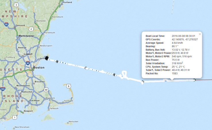
About 200 miles due east of Boston, a robotic boat is putting along
at a walking pace on what could be an historic journey across the entire
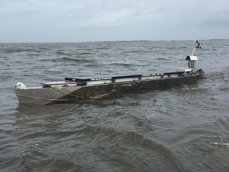
Atlantic. “Solar Voyager,”
built by two friends in their spare time, would be the first autonomous
vessel to cross that ocean — and the first one to cross any ocean using
solar power alone.
Isaac Penny and Christopher Sam Soon have been tinkering away on the
project for four years now and, while the craft, which they launched on
June 1, still has a long way to go, it’s safe to say it’s already a
success in many ways.
“We’re sort of saying, look what you can do with a small group of
people who are passionate about what they do,” Penny told me on the
phone.
“It’s not like Christopher and I are super-geniuses or something.
We’re not even marine people.
I grew up in Kansas!”
Nevertheless, the two built Solar Voyager from scratch, with only the
solar panels and some standard motor parts taken off the shelf.
The
18-foot boat is slowly making its way between GPS waypoints and, if all
goes well, it should arrive in Portugal this fall.
The craft isn’t the first autonomous boat to cross an ocean — Liquid Robotics and its Wave Gliders were the first to do that back in 2012.
But those harvested wave energy to move, not solar, and, as Penny
pointed out, the project was funded and staffed by a major, experienced
company and the resulting technology was patented.
“Only Liquid Robotics can build a Wave Glider, but anyone can do what we did.
We don’t even have a garage!” laughed Penny.
Over the last four years, the boat evolved from a jury-rigged plastic
kayak to a full-on custom aluminum hull with home-made, home-tested
propulsion and electronics.
It has a 280-watt solar array, a specially
made fouling-resistant propeller, a barnacle-resistant coating and a
whole lot of small design tweaks to keep the thing running for the four
months it should take to get where it’s going.
“Durability is the obvious problem, but there isn’t an obvious
solution,” Penny said.
“Designing something that runs for a day is one
thing — designing something that will run for months in such harsh
conditions with no one there to fix it is different.”
They have to get it right the first time, because it’s their only
chance.
Unlike Liquid Robotics, they can’t build a fleet or set up a
waypoint halfway to Lisbon where the craft can be serviced.
If the motor
breaks down or the batteries fry, that’s four years and somewhere north
of 10 grand down the drain.
And that’s if a shark doesn’t attack it or
an oceanliner doesn’t smack into it — the boat is radar-visible and
painted to be highly visible, and it avoids shipping lanes, Penny noted.
Once it arrives in Portugal, Solar Voyager will circle its final waypoint until Penny and Sam Soon can go collect it.
“We’re actually looking for people in Lisbon who own a boat.
That’s
probably not something people want to read about in tech news,” he
added.
But it’s a charming reminder that this is the work of a couple of
guys in their spare time, not a sponsor-studded XPRIZE entry or
Navy-backed prototype.
So, Portuguese TechCrunch readers out there, get
in contact with the Solar Voyager guys if you want to help them out.
More than anything, the project is aimed at promoting the suitability of solar power for this sort of endeavor.
“We always think about solar as this alternative energy thing, but
you just couldn’t do this with fossil fuels — you couldn’t build
something that will run forever,” Penny said.
“Whether it’s long
endurance drones, or data gathering for maritime security, or monitoring
wildlife preserves — solar isn’t just an alternative form of energy,
it’s the best solution.
It brings something to the table that nothing
else has.”
You can track the progress of Solar Voyager at the project’s website;
it updates its location and vital statistics every 15 minutes.
Check
back in October when, hopefully, Penny and Sam Soon will be celebrating
the craft’s successful transit — and a little bit of history being made.