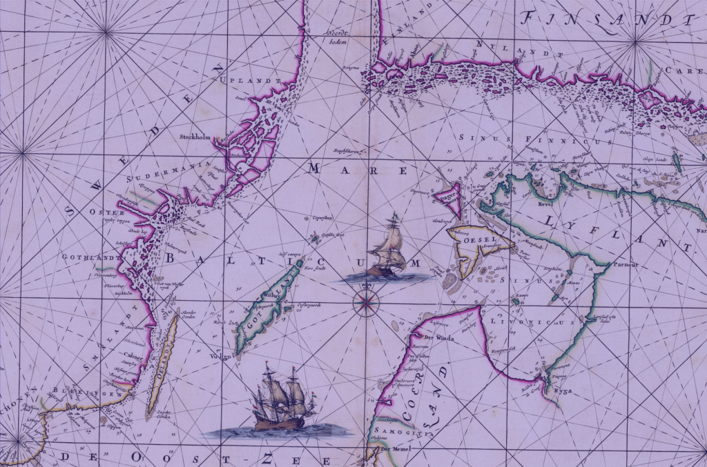
Saturday, June 1, 2024

The many milestones of Alvin


Get to know Alvin, the deepest-diving human-occupied research submersible in the United States! Commissioned by the US Navy and operated by WHOI since 1964, this iconic sub has enabled countless discoveries and insights into our ocean planet. 
 
visit WHOI websites : History of Alvin / Alvin turns 60

Friday, May 31, 2024

Save our seabed – the bottom of the ocean needs to become a top priority, and the UN agrees

Seagrass meadows are a hugely important store of blue carbon - and so is the rest of the ocean sea floor. 
 Philip Schubert/Shutterstock
 
From The Conversation by William Austin

“The science we need for the ocean we want” – this is the tagline for the UN Ocean Decade (2021-2030), which has just held its first conference in Barcelona, Spain.
Marine scientists from around the world, including me, gathered alongside global leaders to chart the progress of this ten-year mission to improve ocean health and marine biodiversity.
That includes finding ways to better protect the seabed which we still know relatively little about.

Some areas of sediment on the sea floor hold large stores of carbon.
Without greater protection, disturbance from bottom-trawling fishing practices for example, could release some of that stored carbon back into the atmosphere.

I joined discussions in Barcelona that have led to the launch of a new sustainable ocean planning initiative, to be coordinated by Julian Barbière, global coordinator of the Ocean Decade.
This aims to encourage commitment to sustainable management of 100% of sea area under a nation’s jurisdiction.

With this in place, there’s scope to reimagine the role of the ocean in our wider climate system and recognise that all marine natural systems sequester and store carbon in their soils and sediments.

I’m here on behalf of the global ocean decade programme for blue carbon – that’s any carbon that is stored in the ocean.
This project is one of the UN’s 50 programmes aimed at delivering transformative ocean science solutions for sustainable development, connecting people and our ocean.
That’s a big ask.

My work focuses on the extraordinary ability of coastal ecosystems – such as mangroves, salt marshes and seagrass – to sequester or store organic carbon in unusually high densities.
Our blue carbon team of international research scientists from more than 20 countries is beginning to define emerging blue carbon ecosystems such as kelp forest and sub-tidal sediments as solutions to manage the climate and biodiversity crises.

The 360 million sq kilometres of ocean and sea floor, from coastal seagrass meadows to the sediment that slowly accumulates within the deepest trenches, are massively overlooked as a precious carbon store.
Oceans hold vast stores of carbon – the top metre of the ocean holds an estimated 2.3 trillion metric tonnes.

The seafloor is not a resource to be relentlessly exploited, but a vulnerable repository of global biodiversity and carbon that needs protecting.
These highly productive, yet vulnerable, ecosystems have been greatly affected by habitat loss and destructive practices such as deforestation of mangroves for shrimp aquaculture in the relentless development of the world’s coastal zones.

Blue carbon has huge potential to provide ocean-based solutions to help mitigate climate change, and thankfully, at the global scale at least, these losses have slowed in recent years.

The potential for blue carbon to reduce greenhouse gas emissions is relatively modest, but healthy, restored ecosystems have the potential to store an extra 2.96 million tonnes of carbon annually.
Certain countries, such as Indonesia, offer huge potential as blue carbon hotspots where the protection and restoration of nature are an opportunity, for both the environment and local communities.

Carbon credits, the means by which additional carbon can become a source of investment income in that community, are gaining much interest.
Off the coast of Kenya, the community-based Miko Pamojo project enhances direct benefits to local people from mangrove restoration. 
 

Collecting a sediment core to assess carbon sequestration rates in the sediment of a tidal seagrass bed.

Blue carbon ecosystems can help countries meet their climate obligations and have been attracting considerable interest.
However, if nations want these ecosystems to continue to provide a whole range of services our governments must protect them and, where possible, restore lost habitats.

Most governments have been stubbornly slow to prioritise ocean-based solutions high up on the agenda of global climate negotiations.
At this conference, I’ve heard more people, including Unesco’s director general Audrey Azoulay, driving home the need to protect and effectively manage our ocean resources.

Members from the traditional owners of the Great Barrier Reef spoke of “country” from a perspective of a long and sustained human relationship with nature and are intimately connected to the ocean.
There is a growing recognition and respect for this indigenous knowledge and our need to integrate that into a sustainable ocean future. 

Reimagining the ocean’s role 

It makes sense to start by protecting these natural systems that already hold vulnerable stores of carbon – this is sensible risk management.

As nations continue to exploit the marine environment for fishing, fossil fuels and even precious metals which are now being mined from the sea floor in certain places, it is time to rethink the value of these vast natural stores of ocean carbon.

Space science gets way more funding than our oceans, yet vast areas of the global deep ocean remain largely unmapped.
Life below water” is by far the least funded of the UN’s 17 Sustainable Development Goals.
That needs to change through a sustained and increased investment in ocean science and greater recognition for the value of our blue economy – defined by the UN as the sustainable use of the ocean’s resources for economic growth, improved livelihoods and jobs.

Stepping back to pause and preserve what already exists in the ocean can help the planet, and us, build resilience and create a healthier and more sustainable marine environment.
The seabed forms the foundation for an interconnected ocean ecosystem and acts as an important long-term global sink for carbon that involves the whole ocean and its exchanges with the atmosphere and wider Earth system.

While plans are finally moving in the right direction, there are huge challenges ahead.
To paraphrase Cynthia Barzuna, director of ocean action 2030 at the World Resources Institute, “there is no wealthy ocean without a healthy ocean”.
The biggest takeaway from the Barcelona conference is that a sustainable ocean future depends on a shared vision that works for all of us and marine life too.
 
Links :

Thursday, May 30, 2024

Mapping the approaches to Mawson Antarctic base

Composite image depicting Nuyina‘s multibeam echo sounder producing a 3D map of the seafloor topography.
Image courtesy AAD.
 
 From Spatial Source by jnally 

Seafloor features and potential shipping hazards on the approach to Mawson research station, have been precisely mapped for the first time using bathymetric instruments aboard RSV Nuyina, Australia’s Antarctic research vessel.

Mapping and Spatial Data Manager, Ursula Harris, from the Australian Antarctic Division (AAD), said the Nuyina’s advanced capabilities will enable updates to be made to the bathymetric maps of the approaches to all of Australia’s Antarctic and sub-Antarctic stations.
“Nuyina allows us to do modern seafloor surveys that meet new data and safety standards required by the Australian Hydrographic Office,” Ms Harris said.
“We’ll be able to use these data to produce new electronic and hard copy charts that will improve navigational safety and support our stations’ resupply operations each season.”
 
Localization of the Mawson Station with the GeoGarage platform (AHS ENC charts)

During a recent voyage, 719 square kilometres of seafloor was mapped off Mawson research station with depths ranging between 20 and greater than 550 metres.
The area had been previously mapped by the icebreaker Aurora Australis using a single beam echo sounder.
In contrast, Nuyina’s multibeam echo sounder mapped the seafloor on the approaches to Mawson with swaths up to 1.8 km wide in one pass, and at far greater resolution.

The deeper the seafloor, the wider the swath, with Nuyina capable of mapping up to 20 kilometre-wide swaths at water depths of around 5,000 metres.
 
Echo sounder data of the approach to Mawson station captured on board RSV Nuyina. Background hydrographic data reproduced with permission from the Australian Hydrographic Office 
© Commonwealth of Australia.

“There are a lot of islands, exposed rocks, seamounts, knolls and other hazards around Mawson, so we were really pleased to be able to update our data after more than 20 years,” Ms Harris said.

Nuyina’s Master, Gerry O’Doherty, said the mapping has significantly improved the accuracy of the position of geographical features, and their identity, and included shipping hazards.

One such hazard was the informally named ‘Notta Rock,’ an exposed outcrop that was shown as being below the waterline on charts, affecting the ability to navigate and maintain ship safety.
“At the same time we discovered Notta Rock, we also found that another feature known as Ryrie Rock, was about 2.8 nautical miles south-south-west of its charted position,” Mr O’Doherty said.
“When you consider that many of the soundings and observations in this area were done long before satellite navigation, it’s no wonder inaccuracies exist.”

As well as mapping the Mawson station approach, technicians and bridge officers on board Nuyina operated the echo sounders throughout the ship’s seven week voyage, mapping the seafloor between Hobart, Casey, Davis and Mawson, and covering more than 85,971 square kilometres.

Over the lifetime of Nuyina, as it travels similar and different routes between Australia and Antarctica, the multibeam echo sounders will build a comprehensive picture of the seafloor.

The mapping data will feed in to AusSeabed and from there into the Seabed 2030 initiative to map the world’s ocean floors by 2030.
The data will also be included in the International Bathymetric Chart of the Southern Ocean (IBCSO).
 
Links :

Wednesday, May 29, 2024

Antarctic ice shelf spawns iceberg A-83

May 20, 2024
May 22, 2024

From NASA


A large wedge of ice broke from Antarctica’s Brunt Ice Shelf in late May 2024, the most recent in a series of notable icebergs spawned by the shelf in the past few years.

Soon after the break, the TIRS-2 (Thermal Infrared Sensor-2) on Landsat 9 captured this pair of false-color images.
They are part of a special expanded data collection programcalled LEAP (Landsat Extended Acquisitions of the Poles), which since 2022 has been building year-round image records of glaciers, ice shelves, and sea ice around Antarctica, Greenland, and the Arctic Ocean.

Thermal images like these can help scientists keep watch over Earth’s polar areas, even when the Sun is below the horizon and visible images are unavailable.
In these images, acquired on May 20 (left) and May 22 (right), yellows and oranges indicate areas where temperatures are warmer, like open water or thin sea ice, while blues denote areas of colder temperatures, like the thicker ice of the iceberg and ice shelf.
Notice that the iceberg is already on the move, evident in the widening gap between the iceberg and ice shelf.
 
 
Christopher Shuman, a University of Maryland, Baltimore County, glaciologist based at NASA’s Goddard Space Flight Center, estimated that the iceberg spans about 375 square kilometers (145 square miles), which is about the same size as Portland, Oregon.
The U.S.
National Ice Center confirmed the name Iceberg A-83, which aligns with the longstanding naming convention that relates to where around the continent an iceberg is first observed.


Iceberg A-83 was first spotted off the Brunt Ice Shelf in the eastern Weddell Sea.
It broke from a rift known as the “Halloween Crack” that appeared in October 2016 and grew eastward from the McDonald Ice Rumples.
The rumples are the result of ice that flows over an underwater obstruction, where the bedrock rises high enough to reach into the underside of the floating ice shelf.
This rocky formation impedes the flow of ice and causes pressure waves, crevasses, and rifts to form at the shelf’s surface.


Icebergs, even large ones like those recently released from the Brunt, are part of a natural, cyclical process of growth and decay at the limits of Earth’s ice sheets.
As glacial ice flows from the inland ice sheet and spreads out over the sea, shelf areas farthest from shore grow thinner.
Susceptible to melting from above or below, they are more prone to forming rifts and eventually breaking away.

Although iceberg calving is normal, the Brunt Ice Shelf is feeling the same pressures as elsewhere around Antarctica, including low sea ice conditions.
When less sea ice is present, ice shelves are more exposed to destabilizing wind and wave action.
 
Iceberg A-83 was first spotted off the Brunt Ice Shelf in the eastern Weddell Sea.
(The European Space Agency)
 

The remainder of the Brunt is still holding on to the McDonald Ice Rumples.
But the new Iceberg A-83, along with icebergs A-74 and A-81 that broke off in recent years, have greatly diminished the ice shelf’s area since early 2021.
“As ice shelves get smaller and smaller, they become more vulnerable to extreme events that can, as in the case of the Glenzer/Conger Ice Shelf, lead to destabilization and total loss of the floating glacial ice area,” Shuman said.

The Brunt continues to display fractures on its surface, such as Chasm 2 (west of these images), that are expected to play a continued role in the evolution of this shelf.
Data from Landsat collected year-round, along with insights from other sensors, will help scientists make sense of that future.

Links :

Tuesday, May 28, 2024

The true story of “Adrift” and Tami Oldham Ashcraft’s survival at sea


Tami Oldham Ashcraft and Richard Sharp, just before setting out on their fateful trip.

From AllThatInteresting by Katie Serena

On a 4,000-mile sailing trip from Tahiti to San Diego, Tami Oldham Ashcraft and her fiancé got caught in a category-four hurricane.YouTubeTami Oldham Ashcraft and Richard Sharp, just before setting out on their fateful trip.

The last thing Tami Oldham Ashcraft remembered before being knocked unconscious was hearing her fiancé scream.

When she awoke 27 hours later, she was in the cabin of their 44-foot yacht, laying in several feet of water, surrounded by debris.
Her fiancé was gone and her boat was badly damaged, the result of an unexpected category-four hurricane.

For the next 41 days, Tami Oldham Ashcraft would be alone, adrift in the middle of the Pacific Ocean, fighting to survive.

Three weeks before the deadly storm, Ashcraft and her fiancé Richard Sharp set out on what should have been a routine trip.
Combined, the two had years of sailing experience and spent much of their time cruising around the South Pacific Islands on Sharp’s 36-foot sailboat.
The ocean was as much their home as the land was, and at times, it felt even more so.

In October of 1983, a friend approached the couple and asked if they would deliver a 44-foot yacht, Hazana, from Tahiti to San Diego.
Though the trip was over 4,000 miles, and longer than they had ever gone at one time, the couple felt confident in their ability to do it.

At another time, perhaps they could have.

Three weeks into their journey, disaster struck.
Hurricane Raymond, a category-four hurricane, surprised the couple by changing course sooner than they expected.
As they were already in the path of the storm, the couple attempted to weather it, donning raincoats and boarding up the yacht.
When they did, 40-foot waves and 140-mile-per-hour winds descended on the tiny vessel.

Sharp insisted that Ashcraft board herself up below deck, while he secured himself in the safety harness.
As she closed the door, she heard Sharp shout “oh my god!” before the boat capsized.
The force threw Ashcraft against the wall, knocking her unconscious. 


YouTubeTami Oldham Ashcraft after her trip.

When she awoke, she was surrounded by destruction.
The main cabin was filling with water, the masts were broken clean off, and the sails were dragging in the water.
Despite that, the ship was miraculously still afloat.

Sharp, however, was gone.
The safety harness was dangling in the water, but Ashcraft’s fiancé was nowhere to be found.
Ashcraft believes that the force of the wind was just too strong and that he must have been thrown into the sea and pulled beneath the massive swells.

But Tami Oldham Ashcraft didn’t have time to grieve over her presumed-dead fiancé.
The yacht was sinking, the sails were shot, and she had a gash on her forehead that was increasingly painful.
Upon further investigation, Ashcraft realized that the engine, the navigation system, and the emergency positioning devices were also in disrepair.

Using a broken pole and a storm jib, Ashcraft fashioned a makeshift sail and managed to pump the water out of the cabin.
A search of the drier cabin revealed a sextant and a watch, the only tools that had survived, and the ones she would use to navigate to the closest landmass — the 1,500-mile-away island of Hilo, Hawaii.

Though all the odds were against her, Tami Oldham Ashcraft managed to do it.

Relying on her sextant, canned fruit salad and sardines, and the hope that she’d picked currents that would drift her toward Hawaii, Ashcraft spent 41 days pushing herself to survive.
Eventually, a Japanese research ship noticed Hazana floating just outside the harbor and pulled her into Hilo. 


YouTube‘Hazana’ after it was towed into the harbor at Hilo.

Though her experience was harrowing, and without a doubt a traumatic one, Tami Oldham Ashcraft eventually found solace by writing her story down.

Though she couldn’t even read for six years afterward due to her head injury, she managed to put her entire story down on paper for her book Red Sky in Mourning: A True Story of Love, Loss, and Survival at Sea.
It was later translated into eight languages, published in fifteen countries and has now been made into a movie, appropriately titled Adrift.

“Definitely the hardest part was dealing with Richard being gone,” Ashcraft told the Chicago Tribune in her first interview about her experience after her book was published.
“There were times I didn’t even want to live anymore because I didn’t know how I was going to go on.
I was never going to fall in love again.”

“Actually, while I was in the survival mode, the grief was fairly low,” she continued.
“It wasn’t as intense as when I got to shore and the survival was over, and I could see people together and everything kept reminding me of him.
I just really had a hard time.
But that survival instinct [while at sea] just kicked in.
It helped me to focus, to keep myself on track.”

Today, Ashcraft lives on San Juan Island off the coast of Washington, where she still sails regularly.
Though she still carries the memory of her experience and her fiancé with her every day, she’s gotten married, has two children, and is the picture of happiness.
The only sign of her trauma is a tiny sextant pendant, encrusted with a diamond, which she wears every day.

“It reminds me of how I got home,” she said.
“It saved my life.”

Links :

Monday, May 27, 2024

Charting the challenges in the Baltic Sea

Rumsey collection

From WarOnTheRocks by Julian Pawlak
 
With Finland and Sweden joining NATO, there has been renewed focus on the strategic situation in the Baltic Sea.
By joining the alliance, the two Scandinavian countries almost complete its encirclement of the Baltic and help consolidate allied defense efforts in the region.
Yet the Russian Federation persists in the Baltic, and its influence remains threatening.
Thus many of the optimistic assessments about NATO’s newfound dominance in the region do not reflect the reality, as the alliance has yet to figure out how best to defend against and deter Russia in this particular part of Europe.

For NATO, the defense of the entire Baltic region remains interconnected with the sea lines of communication to, from, and within the Baltic Sea.
Due to the peripheral location of Estonia, Latvia, and Lithuania, reinforcements coming in via the sea remain crucial for bolstering their defense.
Russia, in turn, depends on the same sea lines for significant parts of its trade, transport, and to supply its Baltic enclave, Kaliningrad.
While significant elements of local Russian forces were moved for its war in Ukraine, grey-zone aggression continues.

Looking ahead in the Baltic Sea, NATO and the United States face the challenge of preparing for both defensive and offensive aspects of naval warfare.
To deter, defend, and win any engagement, NATO’s littoral allies should focus on cultivating expertise related to the distinctive features of the Baltic Sea, even while U.S. seapower remains the ultimate backbone of NATO in the region.
The alliance’s Baltic defense concept should reflect the fact that the Baltic Sea is not an uncontested rear area for the three Baltic states’ defense.
It should also build a distribution of forces and firepower that capitalize on the sea’s shallow waters.
Finally, it is crucial to consider how Russia will adapt its allegedly weaker naval posture moving forward.
EEZ map Baltic Sea with the GeoGarage platform

Maritime Essentials

The semi-enclosed Baltic Sea is both a shallow and narrow basin connecting Europe’s northeast.
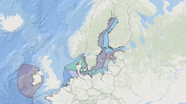
It is composed of the littoral states’ territorial waters as well as their exclusive economic zones — which, under the U.N. Convention on the Law of the Sea, allow foreign vessels innocent passage during peace time.
De jure, there’s no high sea in the Baltic.

Crucially, the Baltic Sea is only accessible via three choke points, which pass through individual countries’ littoral jurisdiction.
The principal entrance routes are from the North Sea via the depths of Kattegat and Skagerrak.
These are bounded by the Danish, Norwegian, and Swedish shores at a maximum distance of 100 nautical miles.
These routes proceed into the Danish straits with its Øresund, the Great Belt, and the Little Belt, all tight waterways with narrow widths and depths limiting navigation.
In addition to this route, there is Germany’s Kiel Canal (used by almost 27,000 vessels in 2023) and Russia’s White Sea-Baltic Canal.
While Russia’s canal carries far less traffic, it is one of several strategically relevant Russian inland waterways built under Tsarist and Soviet rule to connect the Unified Deep Water System of Eurasian Russia.
Finally, between the German and Danish coasts, the Kadet Trench represents an additional, natural but significantly shallow waterway.
Due to critical water depths, it is the sole shipping corridor for larger vessels heading in or out the Baltic via the Kiel Canal, making it one of Europe’s most trafficked sea lines.
All incoming east- and northbound vessels pass Denmark’s Bornholm, one of several larger islands in the Baltic.

Since the beginning of the Hanseatic League in the 13th century, the Baltic has been a crucial corridor for trade and transport.
Today it holds tremendous economic value for littoral states.
Around 15 percent of global container shipping crosses the Baltic — roughly 2,500 vessels daily.
Alongside military and law enforcement vessels, the maritime traffic consists of container, tanker, and commercial vessels, as well as fishing boats and ferry services.

On top of that, a major increase in dark shipping has caused distress in the Baltic and beyond.
Dark ships are vessels without an active Automatic Identification System, which usually transmits the ship’s position together with necessary information for its identification.
Western sanctions against the Russian Federation and its economy have led to an increase of vessels like oil tankers smuggling sanctioned goods, creating new risks for maritime safety and security from the Baltic to South East Asia.

This connectivity is also represented on the seabed, which hosts a network of telecommunication cables, energy transmission routes, and pipelines.
Increasingly, it is also home to a growing number of offshore energy installations.
Finally, adding to the complexity, there are sea mines as well as conventional and chemical weapons lying on the seafloor.
In German territorial waters alone there is estimated to be 1.5 million tons of ammunition stemming from both world wars.

Allied Capabilities and Challenges

The unique requirements of naval strategy in the Baltic emerge from its shallow waters, numerous choke points, islands, and challenging coastal areas, alongside its diverse mix of shipping vessels.
These demand a different approach from blue-water operations on the open oceans.
Crucially, all of the Baltic Sea’s natural and artificial approaches can be monitored and controlled.
They are easy to close or disrupt, be it on purpose or by accident.
Because coasts are never far away, seagoing vessels are always within a short distance of land-based aircraft, coastal defense, and missile systems.
As such, the Baltic exemplifies the multidimensional character of a narrow or littoral sea, where “no single combat arm or service can reach its full potential unless it is employed in combination with other combat arms, branches, and services.”
Any effective strategy for the Baltic should take into account the need for a joint and combined approach to planning, operations, and strategy, including the use of islands and choke points to deny an enemy access.

Yet these constraints do not eliminate the need for other fundamentals of naval warfare, including mine warfare, anti-surface, anti-air, and anti-submarine warfare, as well as amphibious operations.
The fragmented coastlines and thousands of islands create both opportunities to maneuver as well as challenges for the defenders, and short distances favor the use of aircraft with anti-ship missiles against opponent vessels.
Alongside Denmark’s Bornholm, Sweden’s Gotland, Estonia’s Hiiumaa and Saaremaa, and Finland’s Åland islands are crucial.
This geography makes denying an enemy naval force access to a particular area possible through a concerted effort bringing together a combination of services.

That said, despite NATO members’ control of a majority of the coastline, the idea of complete sea control in the Baltic is an illusion.
First, in peacetime, international law grants innocent passage and ensures adversarial vessels freedom of navigation.
During conflict, complete control cannot become reality so long as Russia remains an active presence around the Baltic’s shores.
As stated by the U.S.
tri-service Maritime Strategy, sea control is “[t]he condition in which one has freedom of action to use the sea for one’s own purposes in specified areas and for specified periods of time and, where necessary, to deny or limit its use to the enemy.” This also includes the space below and above the water’s surface as well.
It would not be possible to achieve such level of control and navigate safely in the Baltic without the “neutralization of Russian capabilities.”

Allied naval capabilities largely rely on what are called small navies.
So-called medium navies, such as the Royal Danish Navy and the German Navy, offer a broader set of capacities and capabilities.
They are designed to operate globally on a frequent basis.
For smaller naval forces, their power and influence should be understood with reference to their strategic ends.
In this case, they will have to face the demands of high-intensity naval warfare vis-à-vis the still existing European missile gap.
Yet, Baltic Sea navies are adjusting to regional requirements, with upcoming procurements of new submarines, from the German-Norwegian 212 CD to the Swedish A26 (there are also continuous reports about the Polish Orka program).
Furthermore, allied forces have focused on asymmetric approaches — including increasing investments in coastal defenseand denial capabilities — to generate effects from the sea’s coastlines.
Still, for the time being, the support of Baltic external naval powers like the Royal Navy and U.S.
services
remains central.

There has already been considerable discussion about how the admission of Finland and Sweden will affect NATO’s Baltic strategy.
Both possess significant military capabilities in relation to regional conditions.
Finland’s air force, which will soon include 64 F-35As, has the potential to strike and block maritime targets within the whole Gulf of Finland.
The Swedish submarine-backed naval force is specialized for shallow Baltic conditions and can operate within the sea’s opaque archipelagos.
Finnish and Swedish bases, ports, and infrastructure will now be even more accessible and available to allies.

The Need for Cooperation

In the Baltic maritime area of operations, NATO faces a situation in which it should be able to execute defensive and offensive aspects of naval warfare.
On the one hand, the defense of strategically relevant islands, choke points, and sea lines of communication in general remains crucial.
The maritime realm cannot be treated as a continuation of allied territory or purely as a form of strategic depth.
In case of conflict, movement would be frequently challenged and definitely not guaranteed.
Therefore, NATO forces should not only prepare for far-reaching mine-cleaning operations, but also be able to fulfill offensive operations even in the Baltic area.
Finally, allied navies should remember that challenge in the Baltic is not limited to the possibility of high-intensity conflict.
Already today, violations of allied air spaces and maritime territories, harassment of naval and civilian vessels, sabotage, and espionage are taking place.

NATO states are now forced to increase their capacities and capabilities in the region in all domains.
They realize this calls for coordination and integration among different countries and branches, but they are still moving slowly.
The admission of Sweden and Finland into NATO and the readjustment of European threat perceptions are certainly positive, but internal obstacles, such as fragmented procurement and caveats in sharing intelligence, surveillance, and reconnaissance data, still offer plenty of grounds for improvement.

Thankfully, cooperation is increasing.
The German-led European Sky Shield Initiative aims at merging allied air defense efforts.
Besides being labelled a “procurement initiative,” the battle-proven IRIS-T air defense system is now part of broader European acquisitions.
The goal of creating a joint Nordic air defense, consisting of Swedish, Norwegian, Finnish, and Danish air forces, shows the forward-thinking approach of the Nordic countries.
Finally the British-led Joint Expeditionary Force is increasing its footprint in the Nordic-Baltic region, another important step.

Future Dynamics

Current assessments of Russian military capabilities in the broader Baltic Sea region are mixed.
Moscow’s position in the Kaliningrad Oblast and the western Russian border regions appears comparatively weak.
This is because materiel and personnel have been ordered to Ukraine and the original strength has not been restored.
Yet this mainly applies to land forces, like the Baltic Fleet’s 11th Army Corps, and capabilities like air defense systems.
And it may not prove true forever.
Analysts expect a certain regrowth of the Russian military to take place in the upcoming years.
Besides its fatal losses in the Black Sea, the Russian navy continues to commission new vessels at a pace observers have grudgingly called “impressive.” Kaliningradoffers Russia opportunities to influence the southeastern part of the Baltic Sea region, even as it also serves as a truly vulnerable Russian outpost.
In short, for the Baltic littoral, the Russian threat remains.

Ukrainian innovation and adaptiveness in the Black Sea offers NATO some options in terms of how to respond.
Denial capabilities, paired with increasing intelligence, surveillance, and reconnaissance capabilities, would allow NATO allies ought to better contain Russian naval force in the Baltic.
However, the West should prepare for Russia not only to reconstitute but also adapt its forces based on lessons from the Black Sea.
This could reinforce a dynamic of mutual area of denial — even creating a limited and temporary “maritime no man’s land” for crewed vessels in areas like the southern Baltic.
Due to the Baltic’s narrow character, this is possible even with limited means.

Looking forward, NATO allies should consider the sea’s challenges while orchestrating a capable allied force to defend against and deter potential aggressions.
This includes taking advantage of islands, archipelagos, and coastal areas.
It also means challenging the misleading idea that these islands are “unsinkable aircraft carriers.” Ukraine’s tactics have shown the need for a diversified set of bases and airstrips to cope with Russian strikes.
The problem with islands, however, is that you cannot move them.
So, while many of them are valuable for sea control, they are not invulnerable.
With this in mind, the smaller and more numerous islands along Baltic coasts and archipelagos should be included in planning.
Regional forces could adopt an approach of distributed lethality, while larger NATO assets like U.S.
guided-missile destroyers could support, deter, and fight along the broader northern flank from the North Atlantic up to the Arctic.
Nevertheless, during a kinetic conflict, a NATO including Sweden and Finland should be able to achieve a certain level of control in particular parts of the Baltic, like the Gulf of Bothnia and the Danish straits.

Such high-intensity preparations, however, should be accompanied by serious political preparations.
This means that NATO’s leadership has to prepare for the potential of nuclear blackmail and escalation.
In the event of a kinetic conflict, would leaders in Europe and the United States be willing, for example, to strike the Kaliningrad Oblast to fully diminish large parts of the conventional threat in the Baltic Sea region? Regardless of the answers to these questions, NATO and the United States remain central to defense and deterrence in the Baltic Sea region.
What happens in the Baltic will have major implications for regional defense and deterrence efforts.
As such, it should be of interest to alliance members well beyond the sea’s littoral.

 Links :