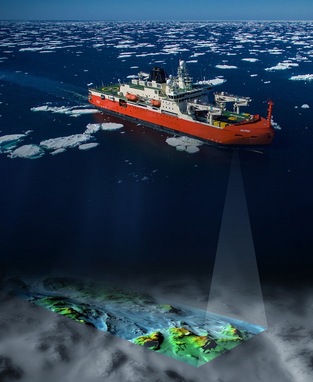
Composite image depicting Nuyina‘s multibeam echo sounder producing a 3D map of the seafloor topography.
Image courtesy AAD.
From Spatial Source by jnally
Seafloor features and potential shipping hazards on the approach to Mawson research station, have been precisely mapped for the first time using bathymetric instruments aboard RSV Nuyina, Australia’s Antarctic research vessel.
Mapping and Spatial Data Manager, Ursula Harris, from the Australian Antarctic Division (AAD), said the Nuyina’s advanced capabilities will enable updates to be made to the bathymetric maps of the approaches to all of Australia’s Antarctic and sub-Antarctic stations.
“Nuyina allows us to do modern seafloor surveys that meet new data and safety standards required by the Australian Hydrographic Office,” Ms Harris said.
“We’ll be able to use these data to produce new electronic and hard copy charts that will improve navigational safety and support our stations’ resupply operations each season.”


Localization of the Mawson Station with the GeoGarage platform (AHS ENC charts)
During a recent voyage, 719 square kilometres of seafloor was mapped off Mawson research station with depths ranging between 20 and greater than 550 metres.
The area had been previously mapped by the icebreaker Aurora Australis using a single beam echo sounder.
In contrast, Nuyina’s multibeam echo sounder mapped the seafloor on the approaches to Mawson with swaths up to 1.8 km wide in one pass, and at far greater resolution.
The deeper the seafloor, the wider the swath, with Nuyina capable of mapping up to 20 kilometre-wide swaths at water depths of around 5,000 metres.
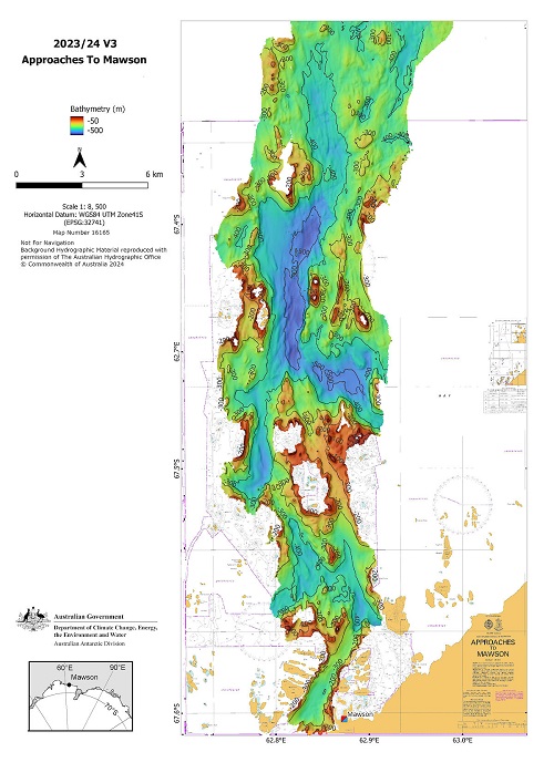
Echo sounder data of the approach to Mawson station captured on board RSV Nuyina. Background hydrographic data reproduced with permission from the Australian Hydrographic Office
© Commonwealth of Australia.
“There are a lot of islands, exposed rocks, seamounts, knolls and other hazards around Mawson, so we were really pleased to be able to update our data after more than 20 years,” Ms Harris said.
Nuyina’s Master, Gerry O’Doherty, said the mapping has significantly improved the accuracy of the position of geographical features, and their identity, and included shipping hazards.
One such hazard was the informally named ‘Notta Rock,’ an exposed outcrop that was shown as being below the waterline on charts, affecting the ability to navigate and maintain ship safety.
“At the same time we discovered Notta Rock, we also found that another feature known as Ryrie Rock, was about 2.8 nautical miles south-south-west of its charted position,” Mr O’Doherty said.
“When you consider that many of the soundings and observations in this area were done long before satellite navigation, it’s no wonder inaccuracies exist.”
As well as mapping the Mawson station approach, technicians and bridge officers on board Nuyina operated the echo sounders throughout the ship’s seven week voyage, mapping the seafloor between Hobart, Casey, Davis and Mawson, and covering more than 85,971 square kilometres.
Over the lifetime of Nuyina, as it travels similar and different routes between Australia and Antarctica, the multibeam echo sounders will build a comprehensive picture of the seafloor.
The mapping data will feed in to AusSeabed and from there into the Seabed 2030 initiative to map the world’s ocean floors by 2030.
The data will also be included in the International Bathymetric Chart of the Southern Ocean (IBCSO).
Links :
- Australian Antarctic Division : Modern mapping at Mawson
- GeoGarage blog : RSV Nuyina discovers deep glacial canyon
No comments:
Post a Comment