Saturday, March 25, 2023

Ocean observation: shaping an ocean of possibilities

The racing yacht "Malizia Seaexplorer" flying over the Pacific Ocean.
By the way, it collects data for scientific analysis during her participation in the Ocean Race.

From Geomar

With the help of the "Ocean Pack", the racing yacht "Malizia Seaexplorer" collects data on the carbon dioxide concentration in the ocean during The Ocean Race 2022-2023.
Photo: Jimmy Horel

Ocean observation: Shaping an Ocean of Possibilities
 
Project under GEOMAR leadership receives funding as Helmholtz Innovation Platform

Researchers of the Helmholtz Association are working on solutions for current challenges in important areas of society, from energy to mobility and health to climate.
In order to transfer research results into practice, Helmholtz is now funding three new innovation platforms with a total of 40 million euros.
One of these platforms that aim to create concrete innovations quickly and flexibly together with external partners, is coordinated at GEOMAR Helmholtz Centre for Ocean Research Kiel under the leadership of Dr.
Toste Tanhua: Shaping an Ocean Of Possibilities for science-industry collaboration (SOOP) builds sustainable structures for ocean observation.

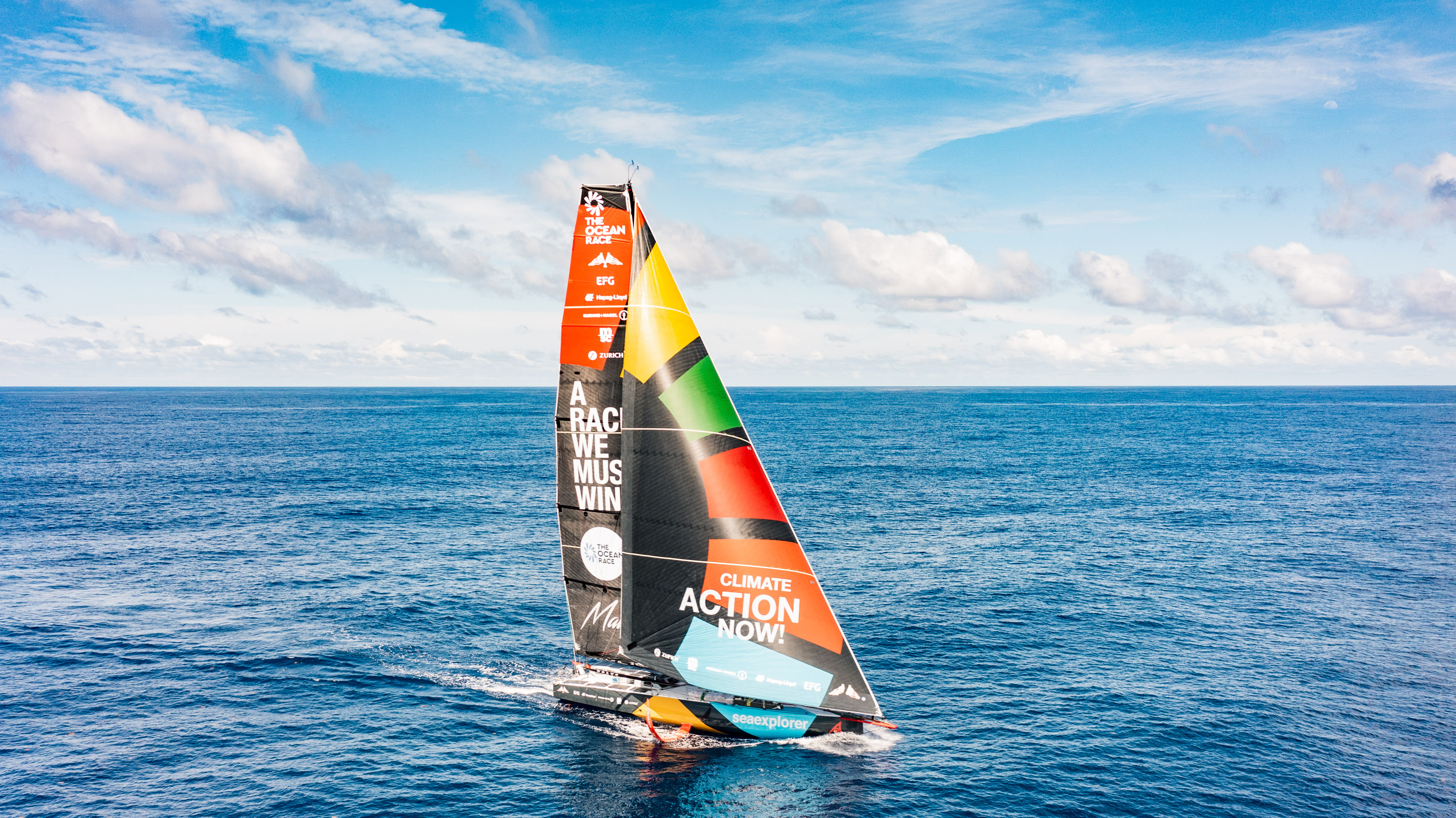
Photo : Antoine Auriol

Scientists at Helmholtz centres are working on often unique, high-performance research infrastructures in relevant fields of application.
Knowledge generated there forms the basis for innovations and new technological developments in industry.
On the other hand, it helps us to understand and shape our environment.
Creating direct access to this knowledge in new, faster cooperation models is an important task of the Helmholtz Association.
As a tool for this, innovation platforms have been set up to create access to ideas and attractive infrastructures.
This facilitates the exchange between the research centres as well as external interested parties.
Helmholtz is now funding three new innovation platforms, including the project “Shaping an Ocean Of Possibilities” (SOOP) coordinated at GEOMAR Helmholtz Centre for Ocean Research Kiel.

The ocean influences us in many ways, regardless of where we live.
It determines the global climate and provides people with food, materials, energy, transport and recreational opportunities.
“Despite its huge importance, we still know very little about large parts of the ocean and changes taking place there,” says Dr.
Toste Tanhua, chemical oceanographer at GEOMAR and coordinator of the SOOP.
“On the one hand, we still lack easy to use and inexpensive instruments to collect sufficient information across regions. On the other hand, we need joint standards for data and analyses. Both are important to support sustainable use and protection of the ocean.”

The SOOP innovation platform develops sustainable structures and technologies for ocean observation to collect important data, improve access to ocean data and thus expand the overall knowledge about the ocean.
To this end, GEOMAR, the Alfred Wegener Institute, Helmholtz Centre for Polar and Marine Research (AWI) and the Helmholtz Centre Hereon bring together stakeholders from industry, civil society and science.
As partners, they will develop devices such as sensors or probes that can also be installed on ships that are not used for scientific purposes, from cruise liners and sailing yachts to global container fleets.
Existing examples for such applications are measurements taken during the global regatta “The Ocean Race” and the expeditions of the German explorer Arved Fuchs, as well as the “Odyssey” project, which contributes to the Global Ocean Observing System (GOOS) as part of the United Nations Decade of Ocean Research for Sustainable Development.

Data collected with these sensors is for example integrated into new models of the ocean and improves early warning systems and statements about ocean health or the distribution of microplastics.
A main focus is on transfer: SOOP aims to open up a larger and more reliable market for ocean sensor technology – with scalable and compatible instruments, easy to use and with known characteristics.
SOOP also has the potential to support stakeholders from low-income countries and indigenous communities, partly through the development of open-source hardware and software.
In this way, the platform can contribute to empowering the Global South in terms of climate change mitigation and adaptation.

“The funding for SOOP highlights the importance of detailed and up-to-date knowledge about the state of the ocean for societal action and policy-making.
Only based on detailed observational data, can we make sustainable decisions for the protection and use of the ocean,” explains GEOMAR Director Professor Dr. Katja Matthes.
“As GEOMAR, we are very proud to lead a network of institutions within and outside the Helmholtz Association and to be able to make our contribution to improved ocean observation.
The activities also contribute to the development of the Global Ocean Observing System in the framework of the Ocean Decade.”

Helmholtz is supporting the three platforms with 40 million euros from the Pact for Research and Innovation.
In close cooperation with strong partners from industry and society, the platforms will strengthen transfer and innovation in the Helmholtz Association and initiate long-term applied solutions.
Funding for HI-ACTS and Solar TAP began on 1 January 2023, while funding for SOOP will start in the second quarter of 2023.

Friday, March 24, 2023

The maritime sector enhances its performances with Galileo


In 2016, Galileo was recognized by the International Maritime Organization as a component of the World Wide Radionavigation Systems (WWRNS).
Since then, Galileo has brought increased performances to maritime users.

On top of Galileo open service, two differentiators stand as flagships of the system for the near future: the high accuracy service (HAS) and the authenticated signal (OSNMA). 
The HAS service was declared operational on January 24.
The OSNMA service is planned to be declared operational by end of 2023.

Galileo SAR as a consolidated service

Galileo SAR (Search And Rescue) service is part of Galileo services launched December 2016.
On January 21, 2020, the unique SAR Galileo with its RLS (Return Link Service) was declared operational, being completely integrated into the Cospas-Sarsat system.
Maritime users benefit from Cospas-Sarsat, which helps them quickly being located in distress situations.
(See Figure 1) SAR beacons for maritime users using Galileo are already in the market.
Visit www.useGalileo.eu to have a database of the available Galileo-capable beacons in the market.


Figure 1: Galileo SAR


The importance of Galileo for the maritime sector

Officially recognized by the International Maritime Organization as part of its Worldwide Radio Navigation System, the importance of Galileo for the maritime sector is increasing over the years.

The use of Galileo could help improving technological innovation and help optimizing routes, contributing to the reduction of emissions due to maritime shipping [2] and therefore contribute to programs like the Zero-Emission Shipping Mission [1] (led by Denmark, Norway and US).

Furthermore, the benefits brought by Galileo have already been proven, being driven mainly through a substantial increase in accuracy, bigger coverage at high latitudes and better resiliency [2] [3] [4].
In practice, this is translated into a reduction of environmental impact, a better prediction of vessels, a decrease of risk collisions and more-efficient maneuverings, among others.

“The maritime community will continue benefitting from Galileo, in addition to the support that Galileo provides to search and rescue operations (Galileo SAR), the maritime community can now benefit from the new High Accuracy Service (HAS) - and soon from the Authentication Service (OSNMA)”, said Rodrigo da Costa, Executive Director of EUSPA, the European Union Agency implementing the EU Space Programme.

Maritime users benefiting from Galileo High Accuracy Service


Since 24 January, the Galileo High Accuracy Service (HAS) is providing free-of-charge high accuracy Precise Point Positioning (PPP) corrections through the Galileo E6-B signal and through internet (upon registration via the GNSS Service Center [5]).
The achieved typical accuracy performance, as depicted in the HAS Service Definition Document [5], is expected to be less than 25cm in the horizontal plane and 30cm in the vertical plane in nominal conditions based on Galileo signals.

For maritime users, a wide range of applications can greatly benefit from this service.
Merchant navigation and pilotage operations in ports, pilotage operations in inland waterways, port bathymetry, riverbed hydrographic survey, coastal seabed hydrographic survey, offshore supply vessels with dynamic positioning, autonomous surface vessels, in port terminal cranes and straddle carriers are some of them.

Thanks to the increased level of accuracy provided by HAS, the efficiency of operations can be improved, benefiting transportation and engineering operations.

Beyond the HAS initial service just declared, EUSPA managing the evolution of the Galileo service is already working on the subsequent evolution towards the HAS Full Service to be developed in the coming years.

For more information about HAS, refer to the High Accuracy Service Info Note Document, the Service Definition Document, the Signal in Space ICD and the Internet Data Distribution ICD, all of them available at :
 https://www.gsc-europa.eu/electronic-library/programme-reference-documents#ACCURACY.

Galileo Authentication as an enabler of safety at the sea

In January 2021, the IMO issued a Resolution for maritime cyber-risk management.
The resolution recognizes “the urgent need to raise awareness on cyber risk threats and vulnerabilities.” During the COVID-19 pandemic, it was reported an increased number of cyberattacks.
It exposed the vulnerabilities of the maritime sector [6].

Galileo Open Service Navigation Message Authentication (OSNMA) provides a means to authenticate navigation data used in the positioning solution, ensuring that the information comes from Galileo Satellites, which significantly increases the security of the solution, contributing to the detection of potential spoofing attacks.

OSNMA is planned to deliver its service by the end of 2023.
It can be used by all types of receivers, as long as they decode the E1B signal component and have their firmware updated to process the new data.
The maritime domain can hugely benefit from this service, given that some key applications demand a new security layer, e.g. position reporting and fleet management.

The use of authentication in position reporting is applicable to any kind of vessels (merchant, fishing and leisure).
Its use is being promoted by IMO and IALA (e.g. Guidelines G1117, G1158).
Therefore, it is likely that for this type of application, authentication will be required in the future.

OSNMA is already transmitted (test phase) so that to allow manufacturers to test their solutions and be ready to introduce the new products in the market once the service is operational.

For more information about OSNMA, refer to the Galileo Open Service Navigation Message Authentication Info Note document, the OSNMA SiS ICD and the Receiver Guidelines, all of them available at :
https://www.gsc-europa.eu/electronic-library/programme-reference-documents#OSNMA.

For more information and support… ask the GNSS Service Centre

The GNSS Service Centre (GSC) (www.gsc-europa.eu) is part of Galileo infrastructure and acts as the interface between the users and Galileo Open (and OSNMA), and High Accuracy services.
GSC is managed by EUSPA, the EU Agency for the Space Programme.

The GSC is actively implied in promoting the use of Galileo among all different domains, maritime included, providing expert support.
Indeed, one of the main services offered is a helpdesk service where users can raise their questions about Galileo services.
Other information such as the status of the constellation, and the updated documentation related to the services offered are also available on the website (https://www.gsc-europa.eu/).
HAS and OSNMA Interface Control Documents and information about the testing campaigns can be found there.
Furthermore, the GSC is responsible for providing OSNMA public keys and certificates accessible to user communities using the service.

Links :

[1] http://mission-innovation.net/missions/shipping/
[2] https://prepare-ships.eu/
[3] https://www.gsc-europa.eu/news/h2h-leveraging-egnss-for-safer-maritime-navigation
[4] https://www.kongsberg.com/es/maritime/about-us/news-and-media/news-archive/2018/kongsberg-coordinates-eu-funded-project-to-enable-autonomous-navigation-in-close/
[5] https://www.gsc-europa.eu/electronic-library/programme-reference-documents#ACCURACY
[6] https://www.dnv.com/cybersecurity/cyber-insights/covid-19-has-increased-chances-of-maritime-cyber-assaults.html
[7]https://www.gsc-europa.eu/electronic-library/programme-reference-documents#OSNMA

Thursday, March 23, 2023

Scientists deliver ‘final warning’ on climate crisis: act now or it’s too late


From The Guardian by Fiona Harvey

IPCC report says only swift and drastic action can avert irrevocable damage to world 

Scientists have delivered a “final warning” on the climate crisis, as rising greenhouse gas emissions push the world to the brink of irrevocable damage that only swift and drastic action can avert.

The Intergovernmental Panel on Climate Change (IPCC), made up of the world’s leading climate scientists, set out the final part of its mammoth sixth assessment report on Monday.

The comprehensive review of human knowledge of the climate crisis took hundreds of scientists eight years to compile and runs to thousands of pages, but boiled down to one message: act now, or it will be too late.

The UN secretary general, António Guterres, said: “This report is a clarion call to massively fast-track climate efforts by every country and every sector and on every timeframe. Our world needs climate action on all fronts: everything, everywhere, all at once.”

In sober language, the IPCC set out the devastation that has already been inflicted on swathes of the world.
Extreme weather caused by climate breakdown has led to increased deaths from intensifying heatwaves in all regions, millions of lives and homes destroyed in droughts and floods, millions of people facing hunger, and “increasingly irreversible losses” in vital ecosystems.

Monday’s final instalment, called the synthesis report, is almost certain to be the last such assessment while the world still has a chance of limiting global temperature rises to 1.5C above pre-industrial levels, the threshold beyond which our damage to the climate will rapidly become irreversible.
Kaisa Kosonen, a climate expert at Greenpeace International, said: “This report is definitely a final warning on 1.5C. If governments just stay on their current policies, the remaining carbon budget will be used up before the next IPCC report [due in 2030].”

More than 3bn people already live in areas that are “highly vulnerable” to climate breakdown, the IPCC found, and half of the global population now experiences severe water scarcity for at least part of the year.
In many areas, the report warned, we are already reaching the limit to which we can adaptto such severe changes, and weather extremes are “increasingly driving displacement” of people in Africa, Asia, North, Central and South America, and the south Pacific.

All of those impacts are set to increase rapidly, as we have failed to reverse the 200-year trend of rising greenhouse gas emissions, despite more than 30 years of warnings from the IPCC, which published its first report in 1990.

The world heats up in response to the accumulation of carbon dioxide and other greenhouse gases in the atmosphere, so every year in which emissions continue to rise eats up the available “carbon budget” and means much more drastic cuts will be needed in future years.

Yet there is still hope of staying within 1.5C, according to the report.
Hoesung Lee, the chair of the IPCC, said: “This synthesis report underscores the urgency of taking more ambitious action and shows that, if we act now, we can still secure a livable sustainable future for all.”

Temperatures are now about 1.1C above pre-industrial levels, the IPCC found.
If greenhouse gas emissions can be made to peak as soon as possible, and are reduced rapidly in the following years, it may still be possible to avoid the worst ravages that would follow a 1.5C rise.

Richard Allan, a professor of climate science at the University of Reading, said: “Every bit of warming avoided due to the collective actions pulled from our growing, increasingly effective toolkit of options is less worse news for societies and the ecosystems on which we all depend.”

Guterres called on governments to take drastic action to reduce emissions by investing in renewable energy and low-carbon technology.
He said rich countries must try to reach net zero greenhouse gas emissions “as close as possible to 2040”, rather than waiting for the 2050 deadline most have signed up to.

He said: “The climate timebomb is ticking. But today’s report is a how-to guide to defuse the climate timebomb. It is a survival guide for humanity. As it shows, the 1.5C limit is achievable.”

John Kerry, the US special presidential envoy for climate, said: “Today’s message from the IPCC is abundantly clear: we are making progress, but not enough. We have the tools to stave off and reduce the risks of the worst impacts of the climate crisis, but we must take advantage of this moment to act now.”


Monday’s “synthesis report” is the final part of the sixth assessment report (AR6) by the IPCC, which was set up in 1988 to investigate the climate and provide scientific underpinning to international policy on the crisis.
The first three sections of AR6, published between August 2021 and April 2022, covered the physical science behind the climate crisis, and warned irreversible changes were now almost inevitable; section two covered the impacts, such as the loss of agriculture, rising sea levels, and the devastation of the natural world; and the third covered the means by which we can cut greenhouse gases, including renewable energy, restoring nature and technologies that capture and store carbon dioxide.

The “synthesis report” contains no new science, but draws together key messages from all of the preceding work to form a guide for governments.
The next IPCC report is not due to be published before 2030, making this report effectively the scientific gold standard for advice to governments in this crucial decade.

The final section of AR6 was the “summary for policymakers”, written by IPCC scientists but scrutinised by representatives of governments around the world, who can – and did – push for changes.
The Guardian was told that in the final hours of deliberations at the Swiss resort of Interlaken over the weekend, the large Saudi Arabian delegation, of at least 10 representatives, pushed at several points for the weakening of messages on fossil fuels, and the insertion of references to carbon capture and storage, touted by some as a remedy for fossil fuel use but not yet proven to work at scale.

In response to the report, Peter Thorne, the director of the Icarus climate research centre at Maynooth University in Ireland, said next year global temperatures could breach the 1.5C limit, though this did not mean the limit had been breached for the long term.
“We will, almost regardless of the emissions scenario given, reach 1.5C in the first half of the next decade,” he said.
“The real question is whether our collective choices mean we stabilise around 1.5C or crash through 1.5C, reach 2C and keep going.”
 
Links :

Wednesday, March 22, 2023

Closing ocean exploration gaps in remote waters

The Saildrone Surveyor, the world’s largest uncrewed ocean mapping vehicle, has mapped more than 45,000 square kilometers (17,375 square miles) of previously unexplored ocean floor during a months-long survey around Alaska’s Aleutian Islands and off the coast of California.
Saildrone Surveyor SD 1200 sails out of Dutch Harbor on Amaknak Island in Unalaska, AK.
 
From Saildrone

The Saildrone Surveyor, the world’s largest uncrewed ocean mapping vehicle, has completed a months-long survey around Alaska’s Aleutian Islands and off the coast of California as part of a multi-agency public-private partnership funded by the National Oceanic and Atmospheric Administration (NOAA) and the Bureau of Ocean Energy Management (BOEM) to address ocean exploration gaps in remote areas with uncrewed surface vehicles (USVs).

The United States Exclusive Economic Zone (EEZ), stretching from the coast to 200 nautical miles from shore, is one of the largest in the world, but it is largely still unmapped, unobserved, and unexplored.
Alaska’s coastline is approximately one-third of the entire US coastline, far longer than that of any other US state or territory.
And yet, Alaska is by far the least mapped region of the US EEZ.

In 2022, the White House released the Strategic Priorities Report for Ocean Exploration and Characterization report, which specifically calls out the Aleutian chain as one of the highest priority regions in the US EEZ for collecting additional data and information in multidisciplinary interests across the Federal space.
Exploration and seafloor mapping of this region has the potential to unlock new opportunities for conservation, climate science, and the Blue Economy.

“Every American, in one way or another, depends on the ocean—from protein from fish to feed animals or humans, to deep-sea cables that make the internet possible.
The only way the US can maximize our ocean resources is to understand what’s there.
This mission is the first step to mapping the seafloor of key regions in Aleutian waters in high resolution.
The beauty of the Surveyor is getting that initial exploration step done faster, cheaper, and without as much staff,” said Dr. Aurora Elmore, Cooperative Institute Manager at NOAA Ocean Exploration.

Saildrone Surveyor SD 1200 sails in rough, windy conditions across the North Pacific on its way back to California in October 2023, as captured by the vehicle’s onboard cameras.

To the unknown and back


Saildrone Surveyor SD 1200 departed Saildrone HQ in Alameda, CA, to sail across the North Pacific to the survey area around the Aleutian Islands in July 2022.

For 52 days between August and October, the Surveyor mapped 16,254 square kilometers (6,276 square mile) of unknown seafloor around the Aleutian Islands.
Mission collaborators were able to follow the data collection in real time.
Preliminary data revealed unprecedented detail of the Aleutian arc seafloor, including previously unknown structures, some of which indicate potential hydrothermal vents.

Amukta Canyon in the Bering Sea, as mapped by the Saildrone Surveyor during the Aleutians Uncrewed Ocean Exploration expedition.
 
Amukta Canyon with the GeoGarage platform (NOAA raster map)

Severe weather is the norm in the Aleutian region, with violent storms and persistent fog.
During the mission, the Surveyor was diverted south to a secondary priority area to avoid the remnants of Typhoon Merbok that pounded Alaska with gale-force winds.
“Part of the premise of the mission was to test the Surveyor to its limits,” said Rachel Medley, chief of the Expeditions and Exploration Division at NOAA Ocean Exploration and NOAA co-chair for the Interagency Working Group on Ocean Exploration and Characterization (IWG-OEC).

Despite 35-knot winds and wave swells over 5 meters (16 feet)—conditions that would have proved too challenging for most crewed survey vessels—the Surveyor continued to collect high-quality data without risk to human life and with a reduced carbon footprint.

In addition to high-resolution mapping sonars, the Surveyor carried technology from the Monterey Bay Aquarium Research Institute (MBARI) to sample environmental DNA (eDNA).
Outfitted with the Environmental Sample Processor (ESP)—a groundbreaking “lab in a can”—the Surveyor was able to collect important clues about marine biodiversity and ocean health from the genetic “fingerprints” left behind by marine life that can inform our knowledge about marine biodiversity and ocean health.

 
Top and side views of the 1,000 m seamount mapped by Surveyor SD 1200 using its Kongberg 304 echo sounder during the second part of the Aleutians Uncrewed Ocean Exploration expedition.

New discoveries—right off the coast of California

After transiting 2,000 nautical miles back to San Francisco and a brief pit stop at Saildrone HQ, the Surveyor was tasked to map additional priority areas a few hundred miles off the coast of California.

The Surveyor mapped an additional 29,720 square kilometers (8,665 square nautical miles) of the US EEZ and discovered a previously unknown seamount standing approximately 1,000 meters (3,200 feet) high from the seabed.
Discoveries like this improve our understanding of the physical processes of the ocean and help scientists identify unique habitats that need further exploration.

The future of ocean mapping

Accurate and up-to-date topography of the ocean floor is essential for understanding how ocean currents move heat and carbon around the planet, sustainably managing resources, tsunami and storm surge forecasting, safety of navigation, telecommunications, developing and maintaining coastal infrastructure, and establishing new offshore energy sites.
Oceans cover more than 70% of Earth’s surface, but as of June 2022, less than 24% of the global ocean has been mapped using modern technology, leaving most of the planet unmapped and unexplored.

This is because the traditional method of exploring and mapping the ocean with large survey ships is difficult, time-consuming, and expensive.
The global Seabed 2030 initiative and the National Strategy for Mapping, Exploration, and Characterization (NOMEC) of the US EEZ have set ambitious seafloor mapping goals, which cannot be achieved with the current global survey fleet alone.


Rigorous sea trials showed that the data quality the Surveyor collects rivals that of the most advanced ocean survey ships in use today—meeting or exceeding International Hydrographic Organization standards.

The Saildrone Surveyor represents a paradigm shift in how we explore our oceans, carrying the same cutting-edge sonar equipment as survey ships to deliver high-resolution data to the global community—at a fraction of the cost and carbon footprint.

“Surveyor brings a new and exciting capability for ocean exploration and mapping.
Mapping in the Aleutians is not trivial, and the conditions there can be austere any time of year.
The Surveyor weathered the storms, collected high-resolution bathymetry, and put no humans at risk.
This mission proves that long-endurance USVs provide a viable option to achieve the goals of NOMEC.
This is the future of ocean mapping,” said Brian Connon, Saildrone VP of Ocean Mapping.

The Aleutians Uncrewed Ocean Exploration expedition served as an excellent example of how public-private partnerships and uncrewed surface vessels (USVs) like the Surveyor can increase the pace and efficiency of seafloor mapping and help us reach national and international goals.
Whether used on their own or paired with traditional ship-based operations, USVs can act as force multipliers, expanding capabilities in a way that is cheaper, more environmentally friendly, and safer.
 
The total area mapped by Saildrone off around the Aleutian Islands and off the coast of California.
 
What happens to the data?

NOAA Ocean Exploration is already using some of the preliminary data collected by the Surveyor to inform its exploration of Alaskan waters with NOAA Ship Okeanos Explorer during its 2023 field season.

These expeditions, the first for the ship in the region, will fill gaps in the understanding of Alaskan deep waters through mapping and remotely operated vehicle operations.
The ROV operations will establish baselines to help sustainably manage and protect Alaska’s deep waters and the resources they provide and contribute to safer navigation and community access, hazard mitigation, and a deeper comprehension of and appreciation for the region’s marine environment.

“NOAA Ocean Exploration is excited to see the results of this remarkable multi-partner expedition come to fruition,” said Jeremy Weirich, director of NOAA Ocean Exploration.
“By joining forces with other federal agencies, academia, and industry, we were able to leverage a variety of expertise and multiple technologies to investigate areas off of Alaska and California that were otherwise unexplored.
In order to map and characterize vast and remote expanses of the ocean, we need new technologies like the Saildrone Surveyor to augment ship-based exploration.”

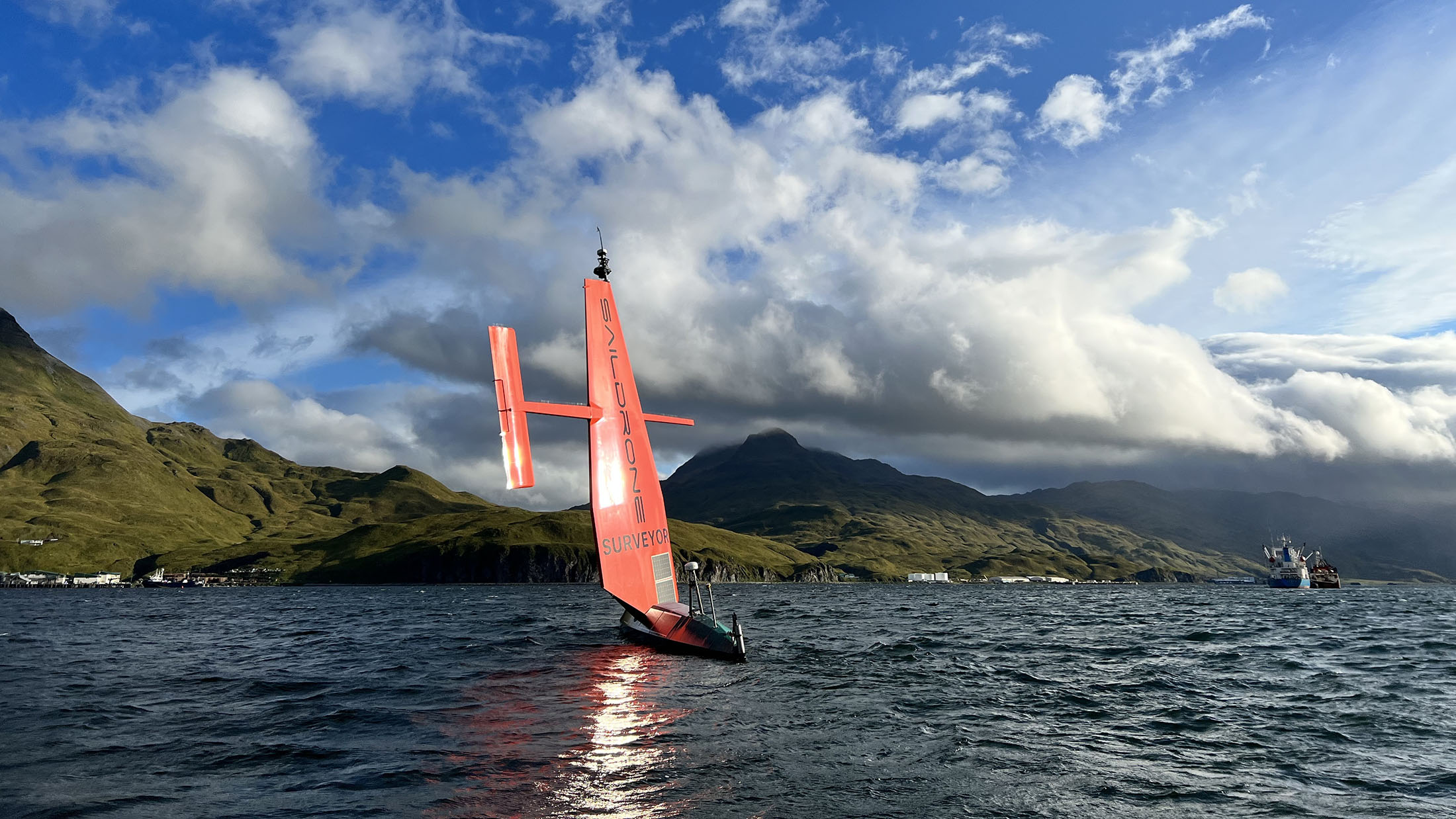
Saildrone Surveyor SD 1200 is escorted out of Dutch Harbor in August 2022.

Once post-processing has been completed by the Center for Coastal and Ocean Mapping at the University of New Hampshire, the high-resolution data collected during the Aleutians Uncrewed Ocean Exploration expedition will be made publicly available through NOAA’s National Centers for Environmental Information to further exploration and characterization efforts and in support of US and international mapping initiatives, including the Seascape Alaska regional mapping campaign.


“This mission is an exciting partnership opportunity with industry, academia, and government to accelerate and advance new US-based technologies that will not only benefit the scientific community but also have the potential to answer some of our largest global challenges by providing a better understanding of ocean dynamics and climate science,” said Medley.

Scaling up the fleet

SD 1200 is the first of Saildrone’s Surveyor class vehicles.
An additional four Surveyor-class ocean mapping vehicles will be built by Austal USA in Mobile, AL, this year to meet increasing global demand for uncrewed survey vehicles.

Links :

Tuesday, March 21, 2023

Feast your eyes on the 2023 submarine cable map


 What has dashing good looks and depicts 529 cable systems and 1,444 landings that are currently active or under construction?
The 2023 Submarine Cable Map!
 
From Telegeography by Kristin Lee

Sponsored by Telecom Egypt, this edition is chock-full of information on new builds, hubs, bandwidth, content providers, and more.

Here's a sneak peek of what's in store for you.

New Builds


Europe, Africa, and the Middle East

These regions are all experiencing a surge in new submarine cables.
Projects such as Equiano and 2Africa are providing a much-needed capacity boost to many countries in Africa and the Middle East.
While Marseille, remains a dominant cable landing site in the Mediterranean Sea, new landings in Barcelona, Genoa, and Crete are improving resiliency.

Asia & Pacific

The geography of these regions necessitates heavy use of submarine cables for international connectivity.
Over $6 billion of new cables are planned to enter service from 2022-2024 that connect to Asia and Oceania.
Several of these new cables are taking unique routes.
For example, Echo and Bifrost will be the first cables to directly connect Singapore to the United States.
The Apricot cable will be the first cable to link Japan and Singapore with a path that goes east of the Philippines.

Americas

North America is seeing increasing diversity in submarine cable landing locations.
New cables are coming into places like Virginia Beach and Myrtle Beach on the U.S.
East Coast.
On the West Coast, the first trans-Pacific cable landings are planned for Canada and Mexico.
Even in south Florida, which has long been a prime location for cables to Latin America, several new cables are planned in a new location in Naples on the west coast of Florida.

Outside of the recently-activated EllaLink cable, South America's submarine cable connectivity remains heavily-focused on the United States.
This trend will continue with the planned activation of cables such as Firmina, Carnival Submarine Network-1, and AMX-3/Tikal.

Bandwidth

International Bandwidth Growth: Globally, the international bandwidth used by network operators has nearly doubled from 2020 to 2022, and has now reached 3.9 Pbps.

Inter-Regional Connectivity: Nearly 82% of the world's inter-regional bandwidth connects to the U.S.
and Canada.
While the United States' centrality may surprise you, it has actually declined substantially over the years, primarily due to an influx of new submarine cables linking Europe to Africa, the Middle East, and Asia.
These cables have shifted more inter-regional capacity towards Europe.


Monday, March 20, 2023

First images of giant iceberg from Brunt Ice Shelf

This is the first footage of the massive A81 iceberg that calved from the Brunt Ice Shelf in late January 2023.
The iceberg is the size of Greater London!
As the summer team left the nearby British Antarctic Survey Halley Research Station they witnessed the start of the iceberg’s journey into the Weddell Sea.
A81 broke free when a large crack in the ice, called Chasm-1, extended across the entire ice shelf.
The iceberg is on the move and is now 150km away from where it broke off.
The Brunt Ice Shelf is one of the most closely monitored ice shelves on the planet and is home to Halley Research Station.
In fact, Halley used to be located on what is now the A81 iceberg, before a major operation was launched in 2016 to relocate the station 23km inland.
The calving has been long expected by scientists, who say this is a natural process in the lifecycle of a glacier.
This is the second major iceberg to come from the region in two years.
Monitoring by British Antarctic Survey glaciologists shows that the research station area currently remains largely unaffected by the calving event.
 
From BAS

British Antarctic Survey (BAS) has released the first aerial pictures of the massive A81 iceberg that calved from the Brunt Ice Shelf in late January.
The iceberg is the size of Greater London.


As the summer team departed the nearby BAS Halley Research Station they witnessed from the air the start of the iceberg’s journey into the Weddell Sea.
The images show the dynamic nature of the iceberg surrounded by smaller icebergs which also broke away.

A81 broke free when a large crack in the ice, called Chasm-1, extended across the entire ice shelf.
It is now floating approximately 150km away from its origin.
The Brunt Ice Shelf is one of the most closely monitored ice shelves on the planet and is home to the BAS Halley Research Station.
Monitoring by BAS glaciologists shows that the research station area currently remains largely unaffected by the calving event.
This calving is a natural process along the Antarctic coastline with A81 the second major iceberg from the region in two years.

Glaciologist Dr Oliver Marsh studies the Brunt Ice Shelf and has just returned from Halley Research Station.
He says:
“This was a calving we knew was coming.
BAS has been monitoring the Brunt Ice Shelf and the chasms formed across it for over a decade.
Since glaciologists first observed Chasm-1 widening in 2012, BAS science and operations teams have been anticipating the calving event.
High precision GPS instruments as well as satellite data have been used to monitor widening of the chasm and in 2016 BAS took the precaution of moving the Halley Research Station inland to protect it.”

After breaking from the ice shelf, the iceberg has spun around and is heading south.
A81 is expected to follow in the footsteps of previous icebergs swept by the strong Antarctic Coastal Current westwards.
BAS scientists and the wider community will continue to track and monitor A81 as it continues to drift through the Weddell Sea and further north towards the South Atlantic basin.

Icebergs on the move

Another massive iceberg on the run is A76A.
This enormous chunk of ice is part of the A76 iceberg that began life after calving from the Filchner-Ronne Ice Shelf in mid-May 2021.
As it travelled north, A76 broke into three pieces, the largest of which is called A76A.
At 135km long and 25km wide, it is the largest floating iceberg on the planet – twice the size of Greater London – and is heading toward South Georgia.
 
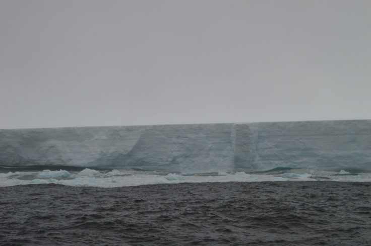
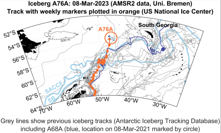
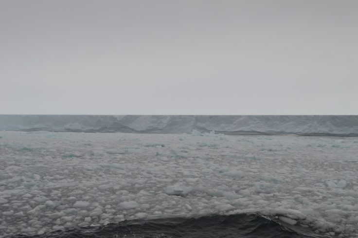
Iceberg A76a was captured by a team on the RRS Discovery.
Photo credit Chris Auckland (BAS)

As the iceberg reaches shallower waters, there is potential for disruption to the local wildlife around South Georgia and the nearby Shag Rocks.
If the iceberg grounds on the shallow seabed in the region it could destroy fauna across the seafloor and disrupt the ocean currents and foraging routes of the local wildlife.
In January, a team of BAS scientists onboard the RRS Discovery, operated by National Oceanography Centre, completed a circumnavigation of A76A sampling the waters around the iceberg to better understand its potential impacts on the environment.
 
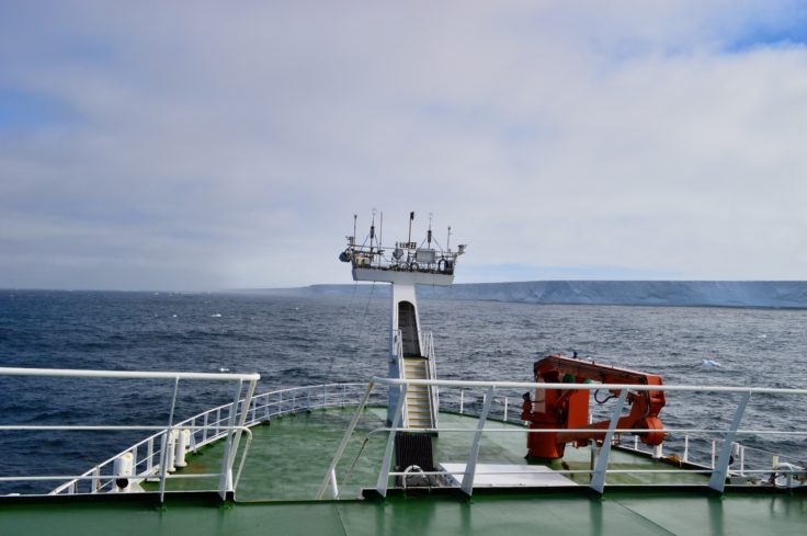
Scientists from BAS were doing research in the region and managed to circumnavigate the iceberg in just under 24 hours to collect measurements on how the freshwater from the iceberg is affecting the ocean.
Photo credit: Chris Auckland (BAS)


Professor Geraint Tarling, head of the Ecosystems team at BAS, was on board.
He says:
“An iceberg of this size will have a big impact on the ocean ecosystems which support the rich diversity of marine wildlife found in this Antarctic region.
These impacts may be both positive and negative.
On the positive side, as the iceberg melts, it will release a lot of nutrients that could benefit the growth of microscopic plants such as phytoplankton at the base of the oceanic food webs.
The negative side is that this same melting, at such a large scale, dumps lots of freshwater into the ocean which decreases salinity levels and makes the waters unsuitable for many phytoplankton and the zooplankton that feed on them.
These effects could then cascade up the food web to fish, birds, seals, and whales.

“In addition, if A76A continues along a trajectory towards Shag Rocks, gouging of the shallow seabed found there may be catastrophic for biodiverse seabed communities, including nursery areas for valuable fish stocks.”

Icebergs around South Georgia are not an uncommon sight.
The giant iceberg A68A reached the southern shelf of the island in 2021 causing concern that it could become grounded in the region.
As the iceberg approached South Georgia, it began to rapidly melt and broke into smaller fragments which were swept away from the island.
Nevertheless, wildlife around South Georgia will still have felt its impact with 152 billion tonnes, 20 times the volume of Loch Ness, of freshwater released by melting.

As well as the ecological impact, icebergs in the South Georgia region can present a great risk to local vessels.

Dr Mark Belchier, from the Government of South Georgia and the South Sandwich Islands, says:
“Our major concern at the moment is the possible risk for vessels operating in the region as the iceberg begins to break up and calve smaller chunks of ice.
It looks as though A76A may end up heading west of South Georgia, not east where A68 broke up, but there is still so much uncertainty around this.
We will be watching its movement closely.”
 
 
The team was able to get to within 500 metres of the giant A76a which is twice the size of Greater London and the largest floating iceberg on Earth.
Photo credit: Chris Auckland (BAS).


A81 iceberg
  • Measures in at 1550 km2 approximately the size of Greater London
  • Calved from the Brunt Ice Shelf on the 22nd of January 2023 and has travelled approximately 150km south following the coastline
  • Formed from the Chasm-1 crack which lay dormant until 2012 and has been closely studied by BAS
  • Expected to follow the Antarctic Coastal Current around the Weddell Sea as with previous icebergs
A76 iceberg
  • Measuring in at approximately 3200 km2 and is shaped like a giant ironing board
  • Calved from the Filchner-Ronne Ice shelf in mid-May 2021 and was first spotted by BAS oceanographer Keith Makinson
  • Broke into three chunks with the largest heading towards Shag Rocks and the island of South Georgia
  • Potential for large disruption to local wildlife as it releases massive volumes of freshwater and nutrients as well as disrupting ocean currents and blocking wildlife foraging routes