Saturday, December 29, 2018

IMO : shaping maritime safety and security

Over the years, the International Maritime Organization has shaped the way international shipping operates.
From codes, conventions and guidelines touching upon safety of life at sea, life-saving appliance, safety of ships in polar waters, guidelines on fatigue, maritime autonomous surface ships and more, IMO has been enhancing the safety of international shipping for decades and is ready to tackle the challenges of the future.

Friday, December 28, 2018

US explorer Colin O'Brady completes first unaided solo trek of Antarctica

Colin O’Brady with black tape on his nose and cheeks, used for insulation when frostnip sets in. Photograph: Colin O’Brady/AP

From The Guardian by Emma Graham-Harrison

Endurance athlete took 54 days to walk 932 miles across frozen continent, dragging a 170kg sled

An American explorer has made the first solo unsupported trek across Antarctica, an epic feat of endurance that took nearly two months and ended with an extraordinary sprint.


Colin O’Brady covered the final 77.54 miles over 32 hours without sleep, a trek he described as an Antarctic ultramarathon, then called his family to tell them tearfully, “I did it!”.

“Something overcame me,” O’Brady said in a telephone interview with the New York Times.
“I didn’t listen to any music – just locked in, like I’m going until I’m done.
It was profound, it was beautiful and it was an amazing way to finish.”

He had spent 54 days in conditions that pushed his body to its limit, battling hunger, cold and solitude, often trekking almost blind through driving snow, struggling over treacherous terrain and pulling weeks’ worth of supplies on a sled.
The total journey was 932 miles.

O’Brady, 33, had called his trek “the impossible first”.
In 2016, Briton Henry Worsley died after calling off the same trek only 30 miles from the end.
Another explorer gave up the quest at the south pole last year.


Adding to the pressure, O’Brady was racing Briton Louis Rudd – a friend of Worsley – across Antarctica, in a competition with echoes of the famous contest to reach the south pole more than a century ago.
The two men set off together, with Rudd taking an early lead, but by Christmas Day he was more than 80 miles behind his American rival.


O’Brady decided to make a final push for the finish line on Christmas Day.
He finally stopped near midnight – but took only 90 minutes to boil water and eat a double ration of dinner.
He told Jenna Besaw, his wife and expedition manager, that he wanted to keep moving.
She and other close relatives questioned O’Brady to check that exhaustion and hunger were not affecting his mind.
“We had an open and honest and smart conversation with him,” Besaw told the New York Times.
“And he totally delivered.” He set off again into the light of an Antarctic midsummer, and reached the edge of the landmass – buried beneath ice but clearly marked – on Boxing Day.

Colin O’Brady drags his belongings across the snow. Personally tailored nutrition bars made up about 50% of his diet.
Photograph: Colin O’Brady/AP

One of the biggest problems for the two men was dragging enough food to keep themselves warm, and moving.
They expected to get through about 10,000 calories a day, and the length of the trip meant it was hard for them to drag enough food at the start.

O’Brady took 280 personally tailored “Colin bars”, drawn up after tests by a nutrition company looking for the smallest allergies, that supplied more than 1,100 calories each, Outside magazine reported.
They made up half his daily diet, but even so, O’Brady began wasting away, he reported on Instagram.
“I’ve lost a ton of weight,” he wrote, six weeks in.
“So much so that I am afraid to take a close look at my body.
My calves feel more like the size of my arms at this point.
My watch is starting to slide around on my wrist and I’ve had to tighten the strap.”

The cold also bit more as he got weaker; later photos show O’Brady with black tape on his nose and cheeks, used for insulation when frostnip – a warning of more dangerous frostbite – set in.

Both men also had to resist temptation when they reached the south pole, where there is a small scientific station.
If they had gone inside, or accepted even a cup of tea from the team working there, their trip would no longer have been considered unsupported.

Other explorers have made the journey across Antarctica alone, but using food supplies dropped along the route for them to collect, or with giant kites that helped them harness the power of the polar winds to cross the continent.

O’Brady lugged his supplies on a sled as he skied in bone-chilling temperatures.
Photograph: Colin O’Brady/AP

O’Brady was the first to make the journey using only the power of his muscles; Rudd, if he completes the trip, will be the second.

For all the intense hardships, O’Brady also celebrated moments of joy and beauty, including sightings of a circular rainbow “glistening overhead”, he wrote.
“It was stunning. I’ve only ever seen this phenomenon in Antarctica and I’m curious why it happens.”

  Colin O’Brady speaks on the phone in Antarctica.
He covered the final 77.54 miles of his trek over 32 hours without sleep.
Photograph: Colin O’Brady/AP

He also got a call from the American musician Paul Simon, who had heard that his album Graceland was helping O’Brady make it through the long days and shared his number with the explorer’s support team.

The two men talked about creativity and commitment.
“Though his expression is music and mine endurance sport, we both could relate so much on the mindset required to attempt to perform at that level,” O’Brady wrote.

With his trip finished, he was looking forward to sleeping.
He plans to wait until Rudd catches up with him so the two men can fly out together.
“I’m delirious writing this as I haven’t slept yet,” O’Brady wrote in a final post.
Quoting Nelson Mandela, he said: “It always seems impossible until it’s done.”

Links :

Thursday, December 27, 2018

These amazing maps greet aliens, aid spies, reveal seafloors

The new book All Over the Map gathers together maps of all types, including this one of plants and animals found in the Pacific region.
It was created by Miguel Covarrubias as part of his Pageant of the Pacific atlas—six enormous, themed maps that he painted as murals for the 1939 San Francisco World’s Fair.
Courtesy of Rumsey and Covarrubias
 
From National Geographic by Simon Worrall

Maps offer much more than directions.
They tell of incredible scientific achievement, bravery, and superhuman precision.

In the age of Google and Waze, maps may seem redundant.
But Betsy Mason, co-author with Greg Miller of All Over the Map, published by National Geographic Books, explains that maps can do much more than help us avoid a traffic jam or find the next Starbucks.
They can map poverty, bring to life the beauty of the Grand Canyon, or record war damage.


London’s Waterloo and Elephant and Castle neighborhoods suffered a lot of damage from German bombs during World War II, as shown on this map that was hand colored to indicate the severity of the destruction as damage reports came in.
Courtesy of London Metropolitan archives

When National Geographic caught up with her in California, Mason explained how a woman named Marie Tharp was one of the first people to chart the ocean floor; how 3-D models created by a top-secret military unit helped plan D-Day; and why extraterrestrials could one day use information carried by the Voyager spacecraft to find us.

The first maps date to ancient Babylon.
Give us a brief history and explain the many different uses maps have been put to.


The lava that flowed from 28 eruptions of Mount Vesuvius between 1631 and 1831 is recorded on this map, with the flows from each eruption marked in a different color.
The oldest eruption recorded on the map (colored pink) was also the largest.
Courtesy of Houghton Library, Harvard University

Our book is not a history of cartography, and it’s not an academic work on cartography.
We like to think of it as a book of stories that happen to be about maps.
When we were choosing maps for this book, our goal was that they should be visually appealing because it’s a large-format coffee table-style book.
But we also wanted to make sure that every map we put in there had an interesting story, either about the map, the making of the map, the map maker, how the map influenced history, or how it elucidates things that you wouldn’t be able to see any other way.
The oldest map is from the third century; it’s a tile of a map of Rome.
We have maps that are still being worked on and maps that were finished just barely in time for our deadline in March.


Profiles of famous landmarks like the Hagia Sophia are recognizable on this groundbreaking 16th-century map of Istanbul by Matrakçı Nasuh.
The painting was a two-page illustration in a written history of the Ottoman Empire.
Courtesy of Istanbul University Library of rare books

One of the most famous maps in the United States is Bradford Washburn’s map of the Grand Canyon.
Tell us about how it was made, and the man behind it.

This is one of my favorite maps ever!
Bradford Washburn was an amazing man.
He was a National Geographic explorer for decades.
He was the first to reach the top of more than a dozen peaks in Alaska and led tens of expeditions, a lot of them in Alaska, starting when he was just 24 years old.

He was also the director of the Boston Museum of Science and wanted to put rock from the bottom of the Grand Canyon in its rock garden.
So he and his wife, Barbara, went to the Grand Canyon.
When they got there they looked for good maps of the area and found that there were none.
His response to this was, “I guess I’m going to have to make a better map myself.”


This 1947 Japanese military map shows the area around Pyongyang, the current capital of North Korea.
Courtesy of Standford University Libraries

He spent eight years making his beautiful map, which involved almost 150 days of field work, and over 700 helicopter landings getting them to various hard-to-reach places in the canyon.
After they finished the fieldwork, he was focused on portraying the canyon in a spectacularly beautiful way.
So he used National Geographic’s own Swiss-trained cartographer to do the relief painting with an airbrush.
What you get is this beautiful, colored map of the Grand Canyon with all the different reds and browns and the green area on the outside showing some of the vegetation that grows near the top of the canyon.
It’s extremely accurate and incredibly beautiful.

The first time I saw it was at an exhibit at the Harvard Map Library and it stopped me in my tracks! As I was researching it, the National Geographic librarian, Michael Fry, contacted me and said, “Hey, we have a bunch of boxes in the archives that are full of materials related to the making of this map.” That’s how I learned how the map was made.
It was this trove of correspondence from Washburn and everybody else who was involved: internal Geographic memos, receipts, and itemized lists of everything that was used.
So it was fun going through it and piecing together the story.
Sorry, I could talk all day about this one! [laughs]


The landscape of Colorado’s Breckenridge Ski Resort has been subtly altered on this map by artist Jim Niehues to let skiers see all the slopes in one easily understandable view.
Courtesy of James Niehaus

By the mid 20th century most of the earth had been mapped, but the ocean floor was still a blank slate.
A redoubtable woman named Marie Tharp changed that, didn’t she?

She was amazing but sadly she was not recognized for her work until much later, though fortunately before she died.
She was one of the few female geologists trained in the early 20th century.
One of the reasons she was even able to go to graduate school was because of the Second World War.
There weren’t as many male candidates to fill geology departments, so a few of them opened their doors to women.
She got a job as an assistant, doing drafting work.
At one point she was paired with another geologist named Bruce Heezen, who was specializing in gathering data on the depths of the sea floor by using sonar on ships.
He was getting these profiles of the Atlantic Ocean floor and, eventually, the rest of the ocean.
She took those profiles, studied them, and started to visualize what was there in the ocean.

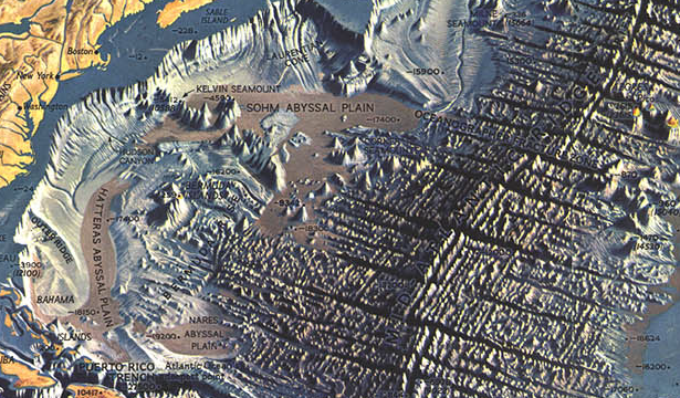
 Atlantic Ocean Floor by Heinrich Berann

She used this technique called physiographic diagrams, where she was drawing, almost in 3D, structures on the ocean floor.
This had never been done before.
Most of the public thought of the ocean floor as this flat, featureless plane, so it was the first time that people had a chance to visualize what it really looked like.
National Geographic paired her and Bruce Heezen with an incredible landscape panoramist from Austria named Heinrich Berann.
He used her physiographic maps to make absolutely stunning portrayals of the ocean floor, as people had never seen it before.

During the Blitz in World War II, the Luftwaffe dropped millions of bombs on London.
A team of cartographers and surveyors kept a real-time record of the destruction.
Tell us about these amazing maps and the circumstances they were made in.

These were truly incredible.
There was a team of architects and surveyors in London who, as the bombs were falling—pretty much as soon as they had landed—would rush out to survey the damage.
They would first take part in trying to rescue as many people as they could.
They would be the ones deciding whether the building was about to collapse and the rescuers had to get out or not, then they would decide whether the building was damaged beyond repair, completely destroyed, or if it was repairable or the damage was just light.
For each of those categories, they put on a map of the city the corresponding color on every single building that suffered any damage.

What you get is this amazing set of 110 maps that cover what is now known as Inner London.
They’re really beautiful, which is a little bit disconcerting because of the destruction and misery that they’re actually portraying.
The surveying team itself lost 54 people in the bombings.
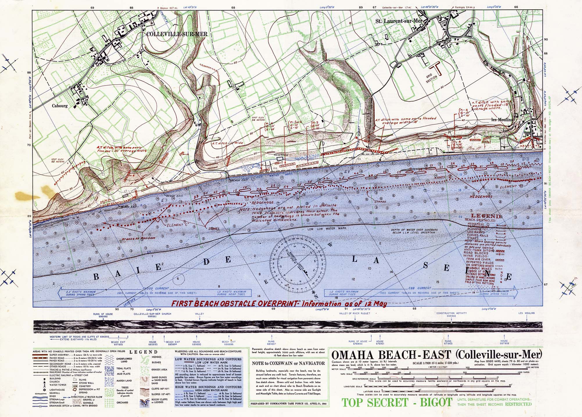
 Omaha beach - East

Maps were also crucial for D-Day.
Describe the incredibly detailed scale models of the Normandy beaches made by the British and Americans, and the effect they had.

This was another amazing, and largely unknown, mapping effort.
There was this small, secret group of American and British military personnel that was tasked with making three-dimensional terrain models of every important battlefield in the war.
These turned out to be extremely useful for planning the attack and for briefing troops who were about to head into the field, because many of them didn’t understand how to read a topographic map or interpret aerial photographs.

The people in this map-making group, which was called V Section, took the accuracy of these models extremely seriously because mistakes could cost lives.
They used the shadows cast on aerial photos to determine exactly how tall buildings should be and developed all kinds of new ways to portray different structures.
They had a machine, which was sort of like a cake icer, to build the hedgerows that are so common in the Normandy countryside.
One man said he even clipped hairs from his moustache to use as the tiny masts for boats that they had put in a harbor.
[laughs]

These maps are credited with saving countless lives and were critical for the planning and execution of D-Day.
The Library of Congress has one of the few surviving examples of these maps, of Utah Beach.
When I saw that I thought, Wow, what is that?

If aliens want to find us, they will probably need maps.
So we’ve sent one up into the heavens with Voyager 1, haven’t we? How was it created?

NASA wanted to send some information out into space on a spacecraft that would help explain what Earth is like.
They tasked astronomer Frank Drake along with Carl Sagan to craft some sort of message to whatever intelligent aliens might encounter this spacecraft, Voyager, as it traveled out of our solar system into interstellar space, which was the plan for the end of its mission.
Frank Drake worked for the Search for Extra-Terrestrial Intelligence—also known as the SETI Institute—so he had spent a lot of time thinking about what other intelligent organisms might have in common with us, how they might see the world, so he wanted to make a map that would show them where our solar system is.
He decided that the best way to do this was to use these things called pulsars, which had been discovered just a few years earlier.
They are the remnants of supernova explosions.
The reason pulsars were appealing is because they’re rotating and they still have some light emanating from them.
These beams of light as they rotate make a very specific pattern of light pulses that you can see through a telescope.
Each one has a signature pulse pattern so you could identify specific pulsars.

Drake felt that any intelligent being that was able to intercept our spacecraft in interstellar space after it left our galaxy would certainly understand what a pulsar was and would be able to understand how to locate our solar system using this map.

People sometimes get a little freaked out by this because they think we’ve sent information to help extraterrestrials come and destroy our way of life.

But, as Carl Sagan said, “Because space is very empty, there is essentially no chance that Voyager will enter the planetary system of another star.”
He still felt that this project was a very hopeful gesture by humans.
The whole project was more about us trying to understand our place in the universe than actually contacting another intelligent species.

Many people of my son’s generation—he’s in his thirties—no longer know how to read a map.
They just use Google.
Is there a danger that in the age of satellites and GPS cartographers that maps will soon join the dodo and become extinct?

[Laughs] I get that question a lot but I don’t personally think there’s much of a risk of that because maps do so much more than just help us navigate.
You can’t use your iPhone screen or Google Maps to understand where pockets of poverty are, or what the geology is beneath the landscape.
That’s the aspect of maps that made me fall in love with them, and that’s the kind of thing that we have tried to select in this book.

We have maps that show things about the human condition, like poverty in London in the 19th century or the first ethnographic atlas, which shows where the origin of the different people of the world was thought to be at the time.
Then we’ve got maps that were used for science.
Sometimes they are just beautiful ways to display the data.
So I hope that people like your son, who don’t have much experience reading maps, might find this book and be delighted by the different stories and all the things that maps can actually do.

Links :

Wednesday, December 26, 2018

What caused the tsunami in Indonesia and why was there no warning?


An eruption of the Anak Krakatau volcano the day before the deadly tsunami was caught on camera by a team from Indonesia's Natural Resources Conservancy Agency.
The sound of explosions can be heard as the volcano emits smoke and lava.
The volcano lies in the Sunda Strait between Java and Sumatra, linking the Indian Ocean and Java Sea. Scientists said Sunday's tsunami could have been caused by volcanic landslides

From The Guardian by Lisa Martin

Underwater landslide may have triggered deadly wave but scientists won’t know exact answer for some time

What happened?

Search-and-rescue efforts were continuing in Indonesia following a deadly tsunami in the Sunda Strait which claimed more than 280 lives.
More than 1,000 people were injured and 11,600 people displaced.
The district of Pandeglang, on the western tip of the island of Java was worst hit, with 207 killed and 755 injured.


It was caused by an eruption of the Anak Krakatau volcano.
A 64-hectare (138-acre) section collapsed into the ocean and this triggered an underwater landslide, officials confirmed on Monday.


Copernicus source

Images captured by the European Space Agency’s Sentinel-1 satellite showed that a large portion of the southern flank of the volcano had slid off into the ocean, scientists said.


Why wasn’t there a warning system?

In the case of tsunamis caused by earthquakes, the shaking earth can act as a warning but it’s much trickier to anticipate tsunamis from volcanic eruptions.

“There’s usually a big draw down in water below low tide levels, so you if you’re on the coast you’ve got a matter of minutes to get to high ground,” Kennedy said.

Sunda Strait tsunami is latest in a series of Indonesian disasters in 2018

Kennedy said if a buoy network had been in place around Anak Krakatau, a one-to-two minute warning of a pending wave was the most anyone could expect.
“The expense of doing that everywhere is just impossible,” he said.

Indonesia has 147 volcanoes and 76 are considered active.

Kennedy said population growth on coastlines and popularity of beach resorts exposed more people to the risk of tsunamis.


Krakatau’s history

Krakatau is part of the Pacific Rim of Fire.
The Australian-Indonesian plate is going back down into the earth underneath the Eurasian plate.

“As the plate goes down into the mantle it actually starts melting, so what you get are volcanoes that sit on top of that,” Kennedy said adding they have a high level of silica which traps the gases as well as water.
“They tend to be really viscous, really sticky volcanoes and they produce massive eruptions. That’s because it’s remixing all the old ocean floor,” he said.


 Localization with the GeoGarage platform (NGA chart)

In 1883, eruptions at Krakatau caused tsunami waves that reached 36.6 meters and wiped out an estimated 36,000 people.
The entire island of Krakatau was vaporised and volcanic gas, ash and rocks spewed 80km high.
The eruptions, turbo charged by steam, were one of the loudest noises heard by human beings in modern in history, Kennedy said.
“There were reports they heard the sound in Darwin and some reports said they heard it as far south as Perth,” he said.
He said the ash clouds from Krakatau cooled the global temperature by over a degree for many years.

Krakatau was quiet until late 1927, when a new eruption began on the seafloor.
The following year a rising cone burst through the ocean.
Two years later it became an island called Anak Krakatau “Child of Krakatau”.

Kennedy said minor eruptions over the years had been slowly building up the edifice of Anak Krakatau.
“You’ve got more magma and lava coming up underneath,” he said.

Links :

Tuesday, December 25, 2018

France & misc. (SHOM) layer update in the GeoGarage platform

230 nautical raster charts updated & 3 new charts added

Sydney to Hobart yacht race 2018 ultimate guide - Start time, competitors, forecast

The Rolex Sydney Hobart Yacht Race is one of the most famous yacht races in the world.
Starting each year on 26 December, it is an examination of the preparedness and resilience of man and machine.
Organized by the Cruising Yacht Club of Australia, in collaboration with the Royal Yacht Club of Tasmania, the 628 nautical mile offshore race stretches physical and mental resources to their limits.
The overall winner of the Rolex Sydney Hobart receives the Tattersall Cup together with a coveted Rolex timepiece, the recognised reward for excellence and a deserved prize for those that overcome not just their opponents, but nature too.
2018 marks the 74rd edition with over 90 yachts entered, including 13 from overseas.

From Nine by WWOS staff & AAP

The Rolex Sydney to Hobart Yacht Race has become an enduring icon of Australia’s summer.
Renowned the world over, the Sydney to Hobart pits the world’s best sailors against each other over 630 nautical miles down the coast of New South Wales, past Cape Howe and around the eastern coast of Tasmania.
The race has been fiercely contested by a host of local and international entrants, with the two-day race asking the best from its competitors and their yachts.


5 Days before the start to the 2018 Rolex Sydney Hobart Yacht Race the World on Water talks to the owner of Super Maxi Comanche on thwir preparations, hopes and team.

Where and When

The 73rd Sydney to Hobart Yacht Race will be held on Boxing Day, December 26th, starting from Sydney Harbour at 1:00pm.

Ones to watch

Of the 11 international entries this year, three come from the United States.
American boats have taken line honours on 11 occasions in the race, but just three times on handicap, the most-recent time in the latter category coming in 2007 through Rosebud.

Another American yacht Joyride also has good recent form, taking overall honours in the 2017 Van Isle 360 and 2018 Vic Maui races, both of which had taken more than 10 days to complete.
Rather than returning home after the latter race concluded in July, it sailed to Australia via a stop in Fiji, as owner John Murkowski decided to tick the Sydney to Hobart off his bucket list, after thinking about contesting the race for a long time.

One of the most-fancied overseas contenders is French boat Teasing Machine, the overall winner of the 2017 RORC Transatlantic race and third on handicap in the Middle Sea race, also last year.
Owner Eric Der Turckheim's previous Teasing Machine was on course to take overall honours in the 2015 Sydney-Hobart before falling victim to the notorious lack of early-morning breeze on the Derwent River, where she was parked for the best part of five hours.


Rolex Sydney Hobart Yacht Race 2017 – Film – The Spirit of Yachting 
The Rolex Spirit of Yachting film series presents the 73rd Rolex Sydney Hobart Yacht Race.
The behind-the-scenes footage in this 25-minute documentary covers the peak moments of this 628-nautical-mile offshore adventure from Sydney Harbour to Hobart, Tasmania.
After a phenomenal contest between Jim Cooney’s LDV Comanche and the Oatley family’s Wild Oats XI, the line honours title for first to finish was eventually attributed to LDV Comanche.
The winners of the coveted Rolex timepieces in honour of excellence on the water were awarded to Jim Cooney, who took home the Illingworth Trophy and set a new race record of 1 day, 9 hours, 15 minutes and 24 seconds, and to Matt Allen, who won the Tattersall Cup for overall win aboard Ichi Ban.
Weather conditions

InfoTrack owner Christian Beck is the one supermaxi boss disappointed by the latest weather forecast for the Sydney to Hobart yacht race starting on Boxing Day.

 Jean-Luc Nélias, navigator on 'Teasing Machine' ready with pre-routing
TrackingStandings

The forecast is for light winds at the start with north to north easterly breezes of about 15 to 25 knots for most of the first couple of days and no heavy weather for the fleet of 85, which includes five supermaxis.
"I think a big heavy boat like InfoTrack, we really need a lot of wind, so it's a bit disappointing for us, really," Beck said.
"We can sort of bash through the really heavy stuff but there is nothing to bash through in this forecast.”

Links :

Monday, December 24, 2018

Wall Street trader reaches bottom of Atlantic in bid to conquer five oceans

Victor Vescovo says: ‘It felt great to get to the true bottom of the Atlantic Ocean for the first time in history.’ Photograph: Richard Varcoe - Special Project Six
 
From The Guardian by Rupert Neate

A multimillionaire Wall Street trader has become the first person to reach the deepest point of the Atlantic Ocean as part of an extreme mission to dive to the depths of the world’s five oceans.

Victor Vescovo, 53, the founder of US private equity firm Insight Equity Holdings, on Friday piloted a $48m (£38m) submarine 8,376 metres (almost five miles) beneath the ocean surface to the bottom of the Puerto Rico trench.

“It felt great to get to the true bottom of the Atlantic Ocean for the first time in history,” Vescovo said.
“Our depth of ignorance about the oceans is quite dramatic. Four of the oceans have never even had a human being go to their bottom. In fact, we don’t even know with great certainty where the bottom of the four are.”

Vescovo has already climbed to the highest peak of each of the world’s seven continents and trekked to both the north and south poles.
But he is not alone in that feat.
At least 62 other people have also completed the so-called explorers’ grand slam.

The project is due to commence later this week with a dive down 8,648m to the bottom of the Atlantic Ocean’s Puerto Rico Trench and all going well it will continue throughout 2019.
Later journeys in the two-person submersible will descend to the South Sandwich Trench (8,428m/27,651ft below the surface of the Southern Ocean); the Java Trench in the Indian Ocean (7,725m/25,344ft); Marina Trench/Challenger Deep in the Pacific Ocean (10,898m/35,755ft); and Malloy Deep in the Arctic Ocean (5,669m/18599ft).
Five Deeps Expedition

Desperate to prove himself as the world’s “ultimate explorer”, Vescovo set himself a fresh challenge: to dive to the deepest point of each of Earth’s five oceans.

He will now head to the South Sandwich trench in the Southern Ocean, about 100km east of the South Sandwich Islands.
That trench, 8,428 metres below the surface, is unnamed and Vescovo hopes his dive there in February will grant him naming rights.
Getting to the bottom of the ocean is not easy, or cheap.
The pressure is more than 16,000 psi (pounds per square inch) – more than 1,000 times the standard atmospheric pressure at sea level.
In order to withstand it safely, Vescovo ordered his specially built submarine at a cost of $48m.

 Victor Vescovo will now head to the South Sandwich trench in the Southern Ocean.
Photograph: Caladan Oceanic

The 11.2-ton Triton submarine, named Limiting Factor, has a 9cm-thick titanium hull built using advanced forging techniques and tested in Russia to conditions equivalent to 13,198 metres, or 20% greater than the ocean’s deepest point.

Vescovo is able to sit back and relax in the vessel’s leather armchairs as it descends to 10,950 metres in less than two-and-a-half hours.
Pilots can explore the ocean using four cameras or look out into the dark depths through three acrylic viewports.

Vescovo, who will be followed on his adventure by cameras from the Discovery Channel, said: “I’ve always loved a great physical and technical challenge and, like those currently attempting to push space technology to the limit, I thought it would be a great goal to push the absolute limits of marine technology.


After the Southern Ocean, Vescovo will dive 7,725 metres to the Java trench in the Indian Ocean.
The fourth dive will be the deepest – 10,925 metres to the Mariana trench, the deepest point in the world.

Twelve people have walked on the moon but only three have ventured to the Mariana trench’s Challenger Deep.
Two explorers – Don Walsh and Jacques Piccard – reached it in 1960 and the Titanic film director, James Cameron, went there in 2012.

The fifth dive will be in the near-freezing waters of the Molloy Deep in the Arctic Ocean.
“We sincerely hope to make history, both technically and scientifically, on this expedition,” Vescovo said.

From Atlantic Productions and coming soon to the Discovery Channel, Deep Planet follows The Five Deeps Expedition. 
This three-minute trailer follows the team during the final stages of testing of the Limiting Factor manned submersible that will journey to the deepest point in each of the world's five oceans.

He is travelling with Alan Jamieson, a marine biology lecturer at Newcastle University, who has embarked on 50 deep-sea exploration missions and hopes to make fresh discoveries about life at the very depth of the world’s oceans.

“Currently, we know more about the intricacies of the lunar surface than we do about the depths of our oceans,” Jamieson said.
“The discoveries made on this expedition promise a world of new scientific innovation in almost every area of biological, geological and oceanographic study.”

 The ship Pressure Drop will be the service vessel for the Five Deeps mission
The Limiting Factor will be transported from one remote location to another aboard a ship named Pressure Drop, which has been adapted especially for this mission. 

Vescovo has always been a high achiever.
He was in the top 5% of his MBA class at Harvard business school, picked up a master’s degree at the Massachusetts Institute of Technology and a double major degree in economics and political science from Stanford University.

He started mountain climbing in 1998 and last year became the 12th American to complete the explorers’ grand slam.
Only 17 people, including one woman and two Britons, have completed the “true” explorers’ grand slam to reach both the North and South Pole and climb the seven summits.
A further 46 people, including Vescovo, have completed the slightly easier “last degree” of the explorers’ grand slam, which requires travelling to within one degree of the poles and not to the exact point.


When all Vescovo’s dives – which will include additional trips to locations including a possible site of the MH370, the Malaysia Airlines flight that went missing in 2014 – are complete, the submarine and its support ship will be available for another super-rich adventurer to buy – for a cool $48.2m.

Links :