Last year was by a narrow margin the hottest ever on record, according to Nasa, with the climate crisis stamping its mark on 2020 through soaring temperatures, enormous hurricanes and unprecedented wildfires.
Globally, 2020 was the hottest year on record, effectively tying 2016, the previous record.
Overall, Earth’s average temperature has risen more than 2 degrees Fahrenheit since the 1880s.
Temperatures are increasing due to human activities, specifically emissions of greenhouse gases, like carbon dioxide and methane.
The average global land and ocean temperature in 2020 was the highest ever measured, Nasa announced on Thursday, edging out the previous record set in 2016 by less than a tenth of a degree.
Due to slightly different methods used, the US National Oceanic and Atmospheric Administration (Noaa) judged 2020 as fractionally cooler than 2016, while the UK Met Office also put 2020 in a close second place.
Regardless of these minor differences, all the datasets again underlined the long-term heating up of the planet due to the burning of fossil fuels, deforestation and other human activities.
The world’s seven hottest years on record have now all occurred since 2014, with the 10 warmest all taking place in the last 15 years.
There have now been 44 consecutive years where global temperatures have been above the 20th-century average.
Scientists said average temperatures will keep edging upwards due to the huge amount of greenhouse gases we are expelling into the atmosphere.
“This isn’t the new normal,” said Gavin Schmidt, director of Nasa’s Goddard Institute for Space Studies.
“This is a precursor of more to come.”
The record, or near-record, heat came despite the moderately cooling influence of La Niña, a periodic climate event.
“While the current La Niña event will likely end up affecting 2021 temperature more than 2020, it definitely had a cooling effect on the last quarter of the year,” said Zeke Hausfather, a climate scientist at Berkeley Earth, which found 2020 was narrowly the second hottest year on record.
“It suggests that we’ve added an equivalent of a permanent El Niño event worth of global warming in just the last five years,” Hausfather added, in reference to the counterpart climate event that typically raises temperatures.
“Records like this further reinforce the need to reduce our emissions sooner rather than later.”
2020 was one of the warmest years on record, with many extreme weather events and #climatechange impacts.
The climate crisis is drastically altering environmental processes across the globe, as the scientific analyses of 2020 show.
The annual average sea ice extent in the Arctic was, at 3.93m sq miles, the joint smallest on record, tied with 2016, while oceans were “exceptionally warm”, Noaa said, with just two previous years recording hotter marine temperatures.
Average annual snow cover for the northern hemisphere was the fourth lowest on record.
Rising heat in the atmosphere and water is causing glaciers to melt, rising sea levels, as well as helping fuel larger and more destructive storms.
“Global warming won’t necessarily increase overall tropical storm formation, but when we do get a storm it’s more likely to become stronger,” said Jim Kossin, an atmospheric scientist at Noaa.
“And it’s the strong ones that really matter.”
Wildfires, fueled by vegetation parched by prolonged heat, ravaged huge areas of California and Australia last year, while the Arctic experienced astonishing temperatures well above average.
“This year has been a very striking example of what it’s like to live under some of the most severe effects of climate change that we’ve been predicting,” said Lesley Ott, a research meteorologist at Nasa.
The UK Met Office has already predicted that 2021 will also be among the hottest ever recorded, with the world now “one step closer to the limits stipulated by the Paris agreement”, said Colin Morice, senior scientist at the Met Office.
Governments will meet later this year in Scotland for crucial UN talks aimed at building upon the Paris deal, which committed countries to avoiding a disastrous global temperature rise of 1.5C from pre-industrial levels.
“We are headed for a catastrophic temperature rise of 3-5C this century,” warned António Guterres, secretary general of the UN.
“Making peace with nature is the defining task of the 21st century. It must be the top priority for everyone, everywhere.”
A lander named Skaff is deployed as part of the Five Deeps Expedition last year. The team’s three landers carried scientific equipment, sensors and cameras to the ocean floor. Other submersibles transported crew members to the deepest places on Earth. (Reeve Jolliffe)
Tired of being stuck at home? Maybe what you need right now is to escape somewhere that the coronavirus, political polarization and devastating natural disasters are nowhere to be found. But where on Earth could you find such a place? Simple: at the bottom of the ocean. Fortunately, Josh Young’s “Expedition Deep Ocean: The First Descent to the Bottom of All Five of the World’s Oceans” is ready to take you there, on a journey that is exciting, suspenseful and ultimately successful.
Make no bones about it — this is an old-fashioned adventure story. Young has written more than 20 books, five of them New York Times bestsellers, and his narrative is wonderfully readable, weaving in scientific, geographic and engineering details effortlessly (a feat much harder to pull off than generally acknowledged). There’s humor and drama and headaches galore, not to mention celebrity cameos and more than one trip to the Titanic. Imagine Jon Krakauer’s “Into Thin Air” with a happy ending.
(Pegasus Books)
The expedition is conceived, financed and led by Victor Vescovo, who seems like a character Tom Clancy dreamed up on a sugar high. This overachieving Texan and former Naval Reserve intelligence officer holds degrees from MIT, Harvard and Stanford (Condoleezza Rice was his adviser), flies fixed-wing jets and helicopters, and founded a billion-dollar private-equity firm in Dallas. In his down time he completed the Explorers Grand Slam, for which you must summit the tallest peaks on all seven continents and ski to both the North and South poles. Like Alexander the Great, who supposedly wept because there were no more worlds to conquer, Vescovo sets a goal of traveling to the bottom of all five oceans because he needs a new challenge.
Coming up with the idea is the easiest part. At nearly seven miles below sea level, the Mariana Trench in the Pacific Ocean is the deepest point on Earth, a far greater depth than Mount Everest is tall. The pressure at that depth is mind boggling — Young compares it to having 290 fully fueled 747 airplanes stacked on top of you. As recently as 2018, only three human beings had ever made the descent, on two different trips more than 50 years apart. Not only had no humans been to the bottom of the other four oceans, scientists weren’t exactly sure how far down they went.
Speaking of which, can you name all five oceans? If not, you aren’t alone. It says something about their widely ignored status that you can probably name more planets millions of miles away than the immense bodies of water that govern our lives in ways we hardly understand. (By the way, the ocean everybody forgets is the Southern Ocean, nicknamed the “screaming sixties” because of the ferocious storms in those latitudes.)
Assisting Vescovo is an international crew of characters, each with their own expertise and often with their own agendas. It isn’t just a matter of throwing money at the problem, you have to design, build, outfit and plan the entire expedition. No one who has ever built a house will be surprised by all the things that go wrong in the course of their journey, but the massive expenses do put home cost overruns into perspective. At a crucial point in their mission a section of the submersible, a titanium structure shielding its occupants from the colossal pressure, literally breaks off. Miles from shore they figure a way around it. (Just in case you were wondering, humans can’t actually walk unprotected on the bottom of the ocean — they would get squashed like a bug long before they could drown.)
Interestingly, it is the little stuff that goes awry. The amount of ill will generated by who gets to post what on social media could serve as a plot line for Bravo’s “Real Housewives.” The challenges of navigating international permits and the rules of exclusive economic zones mean that despite having maritime law on their side, they frequently tangle with local authorities eager to confiscate something, even if they aren’t sure what.
The scientific goals of the expeditions are always secondary, although splurging for the sonar mapping system turns out to be key in verifying their world-record-holding status. But it isn’t just about bragging rights. It is a small miracle to design and build something that can dive miles below the sea’s surface repeatedly and reliably. As Vescovo says, “It’s opening a door that didn’t exist.”
By the epilogue they are ferrying high-profile figures like Prince Albert of Monaco to the bottom of the Mediterranean with a matter-of-factness that would have seemed highly improbable, if not entirely impossible, just 10 chapters earlier.
While the expedition succeeds in its stated goal, the publicity is something of a bust. Even back in May 2019, before the coronavirus and the presidential election dominated the news, Vescovo’s singular accomplishments generate far less interest than the fact that they found a plastic bag at the bottom of the Mariana Trench. It’s a long way from Charles Lindbergh’s ticker-tape parade for crossing the Atlantic.
But along the way to reaching all five “deeps,” something interesting happens. What started out as Indiana Jones on the ocean floor morphs into a story of how progress is made — first in fits and starts, and then in a great rush. In the end, the same traits that brought Vescovo great wealth in the business world are the ones that allow him to succeed in this daunting venture. Knowing when to take a calculated risk and when to abort are key, but small details like having really good coffee for your workers matter, too. Perhaps most important, Vescovo is wise enough to know when to back off and allow his flawed, exhausted but still impressive team members room to breathe and correct their mistakes.
Fundamentally, “Expedition Deep Ocean” is a book about tackling — and solving — really difficult problems. You need talented people with different skills, a level-headed leader and patience for initial failures. It will take a lot of money, and you may never get much credit for your accomplishment. More than just a fun read, these are lessons that we all could use right now. Can we send a copy to Washington?
Want to support ocean conservation and help scientists understand our oceans? Oliver Steeds, CEO of Nekton, outlines the changes you can make to your boat today to turn it from a superyacht to a marine science research vessel... “Citizens of the world…. We are running out of excuses to not take action and running out of time… The time to act is now”.
President Danny Faure of Seychelles was hundreds of feet below the ocean’s surface in a two-person research submersible on Nekton’s First Descent mission broadcasting live to the world. It was the first subsea presidential address and became the biggest news story of the day globally.
Nekton helped President Danny Faure of the Seychelles make a first descent for ocean exploration. Image courtesy of Nekton.
Whilst this submersible was launched off a research vessel, the same Triton submersibles and larger models are being launched off more and more yachts. For scientists, conservationists and ocean explorers, yachts – and sometimes these submersibles – are often the gatekeepers of the ocean. Few have the pass to enter.
The ocean remains the least-explored part of our planet. It is our last great frontier. We know the largest waterfall on Earth is underwater along with the largest mountain range and the majority of volcanic activity.
We know there are over 100,000 seamounts, or undersea mountains, greater than 1,000 metres and that only a handful have ever been visited, let alone biologically sampled. And whilst the average depth of the ocean is over 4,000 metres, the majority of life below 200 metres glows. Over 90 per cent of biodiversity, 3.7 billion years of our evolutionary heritage, remains to be discovered.
The ocean is our planet’s life support system. It regulates our climate, provides food security for billions and essential medicines including the first diagnostic tests and treatment for Covid-19. The ocean produces over half of our oxygen, captures most of our anthropogenic heat and is the largest carbon store on our planet.
But rather than supporting life on Earth, the ocean itself may soon need to be put on life support. It remains the least-protected part of our planet, and only 2.5 per cent of the ocean is currently highly protected. Increasingly, scientists, climate change experts and governments are calling for 30 per cent protection by 2030. There’s much work to be done.
Sadly, too many still have their heads buried in the sand. But marine scientists are pushing back the boundaries of knowledge, which is crucial because we can’t protect what we don’t know.
Nekton mission director Oliver Steeds. Image courtesy of Nekton.
“With endurance to operate in coastal or remote locations, diving capability, tenders, small cranes and accommodation, the private yacht fleet can provide access to the sea to enable and empower marine scientists to work on the frontlines of our changing planet,” explains Mike Pownall, Nekton’s head of marine operations and a veteran of planning, implementing and leading complex offshore and subsea operations.
With a bit of deck space, autonomous underwater vehicles, small “suitcase ROVs” (remotely operated vehicles), drop cameras or baited cameras, sensors, hydrophones and buoys, even water collection systems can all be readily deployed and recovered. Add a slightly larger crane and you can deploy submersibles, and even a larger ROV if the vessel can hold station.
Nekton has used an Omega Seamaster Submersible to 3D map coral habitats.
Image courtesy of Nekton.
Research teams vary in size, from one up to a dozen or more depending on the goal. Without too much bother, critical research can be undertaken on ocean transits, whilst wildlife and surface observations, coral reef research or a vast range of physical, chemical and biological research activities can all be achieved at most locations visited by yachts.
With more available deck space, a modular or containerised system can be considered to house diving systems, submersible operations or even a laboratory.
The Arksen 85 eco-explorer wll be equipped with solar panels. Image courtesy of Arksen.
Utilising a larger tender or the main yacht – with a hull mounted or “over the side” pole mount multibeam echosounder – owners can map the uncharted depths and discover new subsea mountains, trenches, ridges and features and even name them in perpetuity. Yachts can also be the stewards or sentinels of the sea. With meteorological logging equipment, yachts can provide vital data to inform weather and climate science.
“From the design phase up, yachts often have extraordinary capabilities built in that can have dual use for owners and scientists,” explained Andrew Winch, a leading yacht designer. “From power systems to isolated air conditioning in specific rooms through to, more obviously, the tenders and diving equipment, if you can be flexible and adaptable, the opportunities are endless.”
At 57m in length, the bold and rugged Heesen XVenture offers research facilities alongside luxury lifestyle features. Image courtesy of Heesen.
In simple terms, it is all relatively straightforward. There are thousands of marine scientists who have vital research that needs to be undertaken at sea. All it takes is the willingness from yacht owners to invite scientists onto their vessels. Yachts for Science has been set up to be the match-makers – a partnership between the marine research institute Nekton and BOAT International, Arksen and the Ocean Family Foundation.
We can all do our bit. Will you? To help, here’s an introductory guide to the yacht requirements for a range of different research activities along with what more can be done with a few additions or discreet tweaks.
Internal workspace
Scientists will need some sort of workspace, the size of which will vary depending on their research activities. Some simple aspects could be considered: A dry lab with work surfaces for equipment Computational infrastructure: networking for laptops, capability to receive GPS and Gyro feeds from the bridge, additional monitors for survey and video analysis Storage for equipment and, if samples are being collected, then a standard refrigerator (four degrees) and freezer (minus 20 degrees) and a smaller specialist minus-80-degree freezer are all helpful
Designed by Winch, the Heesen XVenture upper saloon offers owners a spot to relax while cruising through icebergs. Image courtesy of Winch Media.
External workspace
A number of aspects can easily make deck space functional to allow “plug and play” adaptability for scientists, including: Deck power – multiple ports in operational areas Fresh and saltwater connections Deck space (variability determines size of research equipment that can be deployed) “Wet Lab” – if sample collection is required (could also be an internal area with direct access to the deck)
Diving
For near shore or coastal operations, a yacht or tender can act as a dive-support base with supply from shore of equipment or divers. Expect scientists to bring their own personal dive gear. To operate further afield, diving capability could include: Equipment: Compressor, tanks, repair kits, spare kits, weight, buoys, freshwater basins to rinse equipment, drying/storage area Safety: Oxygen kits, diving-specific first aid For technical (TEC) diving, below 30 metres: specialist compressors, Nitrox and Trimix makers, recompression chamber and other equipment will be required. On the plus side, technical divers usually bring their own equipment
Owners of the Heesen XVenture explorer can choose to keep a Triton submersible on board. Image courtesy of Heesen.
Submersible operations
Increasing numbers of large yachts have submersibles, and different models from Triton, U-Boat Worx or Seamagine could all be considered. Cranes and support equipment vary for different types of submersibles and depend on sizes ranging from 2.5 tonnes (two persons, 100 metres), 4 to 5 tonnes (three persons, 500 metres), 8 tonnes+ (three to seven persons+, depths from 300 to 1,000 metres). Key functionality to support submersible operations include: Workbench, tools, HP oxygen bottles, storage (spares etc.), high-pressure air compressor, battery charging, tracking and underwater communications systems and a retractable awning to cover the submersible (equipment provided by sub supplier)
For near shore or coastal operations, a yacht or tender can act as a dive-support base with supply from shore of equipment or divers. Image courtesy of Heesen.
Cranes and winches
For the deployment of oceanographic equipment, deck space, crane and electric winch capability – often in combination with RIBs and tenders – define what is possible and can enable the utilisation of: Towed nets (hand deployed/recovered) Baited remote underwater video (BRUV) and/or baited drop cameras Remotely operated vehicles AUV’s (autonomous underwater vehicle), ASVs (autonomous surface vehicle), gliders Small “metocean” (meteorological and physical oceanography) monitoring equipment for short or long-term deployments – such as weather buoys, tide gauges or current monitoring devices CTD (with hydrographic deck winch) for water chemistry research
The Arksen 85 has been designed to cruise anywhere in the world. Image courtesy of Arksen.
Increasing specifications
A-Frames, hydrographic winches, hydraulic deck cranes, dynamic positioning, hull mounting of specific equipment, removable sacrificial deck frames and worktops all increase the scale of research operations and activities
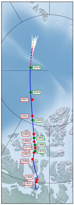
In 1831, the British explorer James Clark Ross determined the position of the magnetic North Pole to within a few miles for the first time.
He found it on the Boothia Peninsula in Nunavut, northern Canada where he and his team camped in the “snow huts of a recently deserted Esquimaux village”.
Even then, the pole was known to move, albeit slowly.
Some 70 years later, the Norwegian Amundsen rediscovered it nearby and over the next ninety years, it migrated slowly northwards at a rate of up to 15 kilometers (just over 9 miles) per year.
Then, in 1990, it suddenly began to accelerate northwards.
In 2017, it passed the geographic North Pole and is now heading south towards Siberia.
Scientists usually update the position of the magnetic pole every five years.
But in 2019, the movement was so fast and unexpected that scientists were forced to issue an extra, irregular update so that navigation devices that rely on it could be corrected.
That raises a significant question.
What is causing the magnetic pole to move so quickly?
And will it ever return to Canada?
Magnetic declination 2020
Tug-of-War
Now we get an answer thanks to the work of Philip Livermore at the University of Leeds in the U.K., and a couple of colleagues, who say the position of the pole is the result of a tug-of-war between two patches of negative magnetic flux sitting below Canada and Siberia.
In recent years, the Canadian patch has significantly weakened allowing the Siberian patch to pull the pole in its direction.
And they say their model predicts the pole will continue to move towards Siberia by up to 660 kilometers (370 miles) in the next decade.
First, some background. Earth’s magnetic field is generated in the planet’s iron-rich core. Like all magnetics it has a north and south pole.
Their exact position on the Earth’s surface depends on how the field is bent and attenuated by the Earth’s mantle.
On the Earth’s surface, the magnetic pole is defined as the place where the magnetic field is perpendicular to the surface and where a freely swinging magnetic needle would point straight down. Ross and Amundsen determined its position by watching the orientation of such needles.
Since 1990, however, satellites have been monitoring the field continuously and this has led to a much more accurate determination of the position.
Earth scientists have long known that the exact position is related to two patches of relatively strong magnetic fields that sit below Canada and Siberia.
Indeed, these patches are involved in a tug-of-war that pushes and pulls the pole back and forth, says Livermore and co.
In recent years, the balance between these patches has changed. “Between 1999 and 2019, the Siberian patch showed a slight intensification from, while the Canadian patch decreased significantly in absolute value,” says Livermore and colleagues.
“Together, these caused the direction of travel of the north magnetic pole to be towards Siberia.”
To work out why this change occurred, the team has simulated the change in magnetic field strength in Canada and Siberia and then used the results to determine what kind of changes in the Earth’s core could have caused them.
They say this happened because of a change in the flow of liquid iron in the Earth’s core in the 1970s and the way the corresponding change in the magnetic field diffused through the mantle to the surface. Siberia Bound
They go on to say that the pole is likely to continue its journey to Siberia in the short term. “A range of simple models that capture this process indicate that over the next decade the north magnetic pole will continue on its current trajectory traveling a further 390-660 km towards Siberia,” says the team.
However, the model is unreliable over longer times scales.
Nevertheless, the team says that the past pattern of movement on these timescales may be indicative of future behavior. “Over the last 7000 years it seems to have chaotically moved around the geographic pole, showing no preferred location,” says Livermore and co. In other words, wherever it goes, the magnetic north pole is unlikely to stay there for long.
Links :
Recent North Magnetic Pole Acceleration Towards Siberia Caused by Flux Lobe Elongation arxiv.org/abs/2010.11033
From The Telegraph by Andrew English Where will the power for our electric cars come from? We visit the Teesside windfarm to explore clean energy generation at first hand
Boris Johnson was in ebullient mood last October when he promised the Conservative Party conference that within 10 years offshore wind farms would generate enough electricity to power every UK home. “Your kettle, your washing machine, your cooker, your heating, your plug-in electric vehicle – the whole lot of them will get their juice cleanly and without guilt from the breezes that blow around these islands,” he said, rehashing a Tory pledge to increase offshore wind capacity to 40 gigawatts by 2030 and promising the creation of 2,000 construction jobs, the support of 60,000 more, and that Britain would become “the world leader in clean wind energy”.
With current offshore wind capacity amounting to about 10 gigawatts, a subsequent study by Oxford-based consultants Aurora Energy Research reckons this pledge would cost £50 billion and involve a new offshore wind turbine being installed every day for the next decade.
So, was this a far-sighted future or just plain-old Boris bluster?
I thought about this without conclusion as I banged along in a chilly one-metre North Sea swell on the Windcat crew transfer vessel steaming south-east from Hartlepool’s historic docks to EDF’s Teesside offshore wind farm.
Teeside Wind Farm in the GeoGarage platform (UKHO map)
Background – and some controversy
This 62-megawatt, 27-turbine facility was constructed between 2011 and 2012 and commissioned in July 2013. Within sight of the imposing 12th century church of St Hilda’s on Hartlepool headland, it was north-east England’s first large-scale wind farm.
EDF's Teesside windfarm is so close to Redcar that it is variously described as offshore and onshore CREDIT: Andrew English
The nautical chart shows the 3.9 square-mile, three-row site of 27 sits on a shallow 10- to 16-metre sea bed of sandy gravel and shells about one mile off Coatham Sands, Redcar, just south of the dredged main shipping channel into the River Tees.
While crab- and lobster-pot fishing is still allowed in the farm, trawling isn’t because of the danger to cables, which didn’t best please local inshore fishermen, who pointed to a lack of research on effects on marine life of the rock “cable-armouring”, which creates underwater reefs. Indeed, the Crown Estates, which leases the seabed, has just committed £25 million towards a five-year Offshore Wind Evidence and Change Programme, aimed at gathering evidence about how to protect and restore the seabed in the face of the unprecedented offshore wind bonanza.
Similarly, there have been issues with wind turbine blades killing seabirds on their feeding grounds such as the Hornsey site.
In addition, there’s a well-mannered standoff between the Royal Yachting Association (RYA) and some wind turbine operators – although not EDF. The RYA is petitioning not to have total exclusion zones around wind farms as some operators would like. With a minimum 22-metre blade height off the water at the highest of tides, most yachts can negotiate a wind farm and there have been no recorded incidents involving wind turbines and pleasure craft in UK waters.
The 27-turbine site is far from new; construction began in 2011 and it was commissioned in 2013 CREDIT: Andrew English
Yet, as an RYA source told Yachting Monthly magazine this year, some operators “are nibbling at the edges”. As an aside, I found it extraordinary that the seafaring rules on radio procedure, identification lighting and identification for a vessel of limited manoeuvrability are generally observed in the breach in the wind industry.
Teesside is an EDF structure, but the “balance-of-plant” infrastructure contract was awarded to Dutch specialist Van Oord, with marine engineering specialist SeaRoc as principal contractor and Siemens as turbine supplier and operator of the farm for five years until EDF took over.
Wind turbines explained
These Siemens SWT 2.3 units are the Ford Focus of the wind turbine world, with the 93 model most suited to efficient generation in moderate wind conditions. Prevailing winds at Teesside are south-west offshore and the farm starts to generate power from wind speeds of about 9mph (Force 3 in the Beaufort Scale, a gentle breeze), with their peak 2,300-kilowatt generation in wind speeds between 25mph (Force 6, strong breeze) to about 56mph (Force 10, storm).
Above that the blades are feathered so they don’t drive and the whole rotor assembly is braked to a halt – they should survive winds speeds of up to 123mph. When they are spinning merrily (or “turning and burning”, as technician Richard Wardle puts it), the entire farm is capable of powering up to 40,000 homes (lately reassessed to 56,000) in the nearby Redcar, Marske and Saltburn areas.
The industry has settled on three-bladed rotors as the best compromise of power generation, cost, turbine speed and noise. At Teesside each glass-reinforced plastic (GRP) rotor is 93 metres long and sweeps an area of 6,800m2. Their maximum speed is 16 revolutions per minute, at which point the blade tips are travelling at 174.5mph.
Each of the three glass-reinforced plastic (GRP) rotors is 93 metres in length and sweeps an area of 6,800m2. The turbines are designed to withstand wind speeds of up to 123mph
CREDIT: Andrew English
While Siemens is currently building direct-drive turbines, this turbine has a Winergy three-stage planetary gearbox, with an overall ratio of 1:91. It takes primary drive up to about 1,500rpm and through the sacrificial drive coupling and into the 690-volt four-pole generator which delivers AC current at the grid frequency of 50 Hertz.
That current is increased to 33kV onboard the turbine, then the electrons are flowed back to land via twin undersea cables to the substation at Warrenby, where two huge transformers step up the voltage to 66kV for more efficient introduction to the National Grid.
Facing into the wind
The UK is well served with wind compared with the rest of Europe, but winds blow hardest and longest in the spring and at night. To face the wind, Teesside’s turbines are controlled with a motorised yaw plate driving the entire nacelle assembly around according to the readings from the wind speed and direction weather station on the back.
English aboard the turbine's nacelle, which opens to permit maintenance
CREDIT: Joe Collins
Except it’s not that simple, since the readings are affected by the turbine blades and those of neighbouring turbines, which create their own propwash. Pointing into the wind might not always be the most efficient and there’s software to adjust the direction accordingly. In fact, there’s even turbulence between wind farms themselves and, in a few cases, one wind farm has had to pay compensation to another for wind turbulence.
You can find Teesside’s “load factor” figures on the Renewable Energy Foundation website, which shows it as middling in terms of its actual-against-theoretical maximum generation productivity.
James Wilson, EDF’s area manager, winces at the average figure of just over 35 per cent (the highest is a Scottish pilot project at 54.8 per cent), but says that’s mainly to do with the site’s location and its intermittent offshore winds.
What Wilson should be (and is) proud of, though, is Teesside’s operational efficiency, which for an older field is exemplary and as much to do with his team of crack technicians and engineers as it is the ease of access to the site.
Serious about safety: a week of training and induction
You’ll not find many reports from inside one of these remarkable machines; news reports tend to be filmed from dry land. The reason for this became clear when I first enquired of EDF, the only company willing to hear me out and one that we’ve had a good relationship with over the years, about going aboard.
Long way up - and down. English begins his ascent to the business end above
CREDIT: Joe Jackson
One of the reasons that the global offshore wind business has such a good safety record is that everyone who goes on a turbine has to have a minimum standard of fitness, a comprehensive medical and six days of intensive training in fire safety, sea survival, manual handling, first aid and working at height.
In spite of the fact that I’m a qualified yacht skipper, a former long-line fisherman, a strong swimmer and the heaviest thing I’m carrying is my Nikon, I was no exception. I can report that the sea-survival training in the eight-degree water of a London reservoir was adequately bracing, although tutor George Buist at MCL training was very reassuring.
“Just about every turbine I’ve been on has been a very safe and professional place to work,” he said as he dragged me out; as a former blade-repair technician, he knows of what he speaks.
The wind turbine gold rush
“A journey inside the whale; you will see such things,” said John Constable, director of the Renewable Energy Foundation (REF) charity. Constable is one of those trying to keep the hype over the offshore wind bounty in check, but it’s difficult not to feel excited – there’s a gold rush into offshore wind at present.
In June Bloomberg was reporting on an offshore wind investment bonanza, with $35 billion invested in the first half of the year including Vattenfall’s $3.9 billion Netherlands array and SSE’s $3.8 billion array planned for the Firth of Forth. UK investment in the first six months was up to $5.7bn, more than 3.5 times greater than the total investment in early 2019.
The head of the turbine unit is rotated for maximum efficiency according to data from its own weather station
CREDIT: Andrew English
Even the young people on the MCL safety course were betting their future on wind energy in the same way young people have been at the sharp end of extractive industries throughout the ages. It’s a tough life but, like mining or the oil rigs used to be, it can be lucrative.
In the relatively shallow waters of the Teesside Bay, turbine construction consisted of driving a 5.5-metre diameter steel monopile, weighing around 500 tonnes, 35 metres into the sea bed from a jack-up vessel and then gently lowering a 300-tonne yellow transition section on top. These two sections provided the foundation for the 80-metre tower with an 82-tonne nacelle containing the gearbox, the rotor and blades, the sacrificial drive and the generator.
Finally onboard
The evening before going aboard I went to Redcar Sands to see the turbines, spinning like ghostly vedettes in the chill Westerly, their warning lights coruscating in the dusk. The nearest ones are absurdly close by the beach and at various times Teesside has been termed offshore and at others onshore.
The morning brings brighter weather and while modern health and safety can sap the joy from any job, even trussed in steel toe-capped boots, warming fleeces, climbing gloves, safety goggles, helmet, a neoprene immersion suit and a safety harness hung with clattering work-positioning and fall-arrest systems, plus my camera bag, it’s hard not to enjoy the 20-minute transfer, seeing a seal and loads of black-headed gulls in winter plumage.
You have to climb from sea level to the lower platform (up the yellow bit, for those of us not of a technical disposition). From there it's a rickety lift for the remaining 80 metres to the top CREDIT: EDF
Team leader Joe Collins has responsibility for taking control of the turbine as we approach, but the day’s paperwork and risk assessments have to be immaculate before the controller in EDF’s onshore base hands over the turbine into his capable hands.
There some clever machinery being developed for turbine access and egress, but here it consists of a tall, sea-swept vertical steel ladder, which you step on to while skipper Malcolm Kirton revs the Windcat’s twin Volvo turbodiesel engines and drives the bow into a couple of J-shaped tubes.
He has to decide if the transfer is safe, then his crewman and then I have a right of veto, although since Collins, Wardle and lead technician Joe Jackson have already swarmed up like a troop of monkeys (an animal close to the hearts of Hartlepool residents), it would be churlish to refuse.
So, I stand at the bow, clip on to the fall-arrest line and make the big step. I don’t mind admitting that this moment (statistically the riskiest in the wind-turbine business) fair sparks up the old ticker and I almost leave finger indentations in the yellow steel rungs. Coming back down is even worse.
Weighed down by an immersion suit and comprehensive safety equipment, English arrives at the lower platform
CREDIT: Joe Jackson
Thankfully EDF hasn’t laid out the red carpet; there’s no fresh paint, or top brass, I’m just part of the crew and the day’s jobs of replacing the galvanic anode plates in the monopile and lubricating the yaw plate gear are going ahead as planned.
Hands-on approach
The size of these turbines changes according to your point of view; up close they are enormous. With ladders, height, high-voltage electricity and the sea, there are a lot of ways to get hurt (lightning is one of the biggest risk elements) so safety isn’t just a meaningless mantra.
The team have a close-knit camaraderie, which surpasses the pecking order and each member takes care of each other; Jackson asks me to check his harness and vice versa. Ladders require complicated fall-arrest bracketry to be attached, which frustrates cold fingers. “Take your time,” says Jackson gently.
The tower has a clanky, echoing quality as I climb the short ladder runs, while my gear graunches against steel. We then cram into a two-person aluminium lift (what luxury), which clatters and grumbles up the remaining 80 metres to the yaw plate. A brief climb to the top and I’m amazed to find the whole nacelle top has opened up like a gently lubricated Bond villain’s lair.
The turbine's nacelle opened ready for maintenance, showing the Winergy three-stage planetary gearbox in the centre
CREDIT: Andrew English
I stand up on the slightly greasy generator, feeling the whole tower swaying underfoot and marvel at the view of the windfarm and Redcar beyond. It’s an irony that while the Teesside British Steel plant has closed at a time when steel is in high demand for newer and bigger windfarms, the turbine’s air-cooling systems are no longer coated in carbon-black emissions from the plant. And there, in the distance, is the Hartlepool advanced gas nuclear reactor, which is also owned and run by EDF.
It’s a changeable day and pretty soon it’s raining and you can feel the chill to your bones; small wonder they try to pack the bigger maintenance jobs into the summer, like last year’s gearbox change.
Conclusion
Offshore wind is big, complicated and expensive engineering, and with the Hornsea and Dogger Bank and other big offshore wind farms under development, it’s increasing in all these aspects.
Government and green groups keep telling us that offshore wind is getting cheaper, but there’s evidence that if anything it’s getting more expensive as plant gets old and firms juggle capital against operational expenditure.
Last year's gearbox change required the use of a jack-up ship and took five days to complete
CREDIT: EDF
Most wind farms are calculated to have a 25-year life, after which most Crown Estates contracts demand the site is cleared and made good. In that time, like all machinery, the turbines need looking after and can go wrong – and that maintenance cycle is complicated by the unquantifiable stresses imposed by salt water, high winds and UV radiation.
Giant automatic lubrication drums and careful design means a wind turbine should be able to look after itself for six months between essential maintenance. But after eight years turning and burning, Teesside’s turbines are ageing and sometimes need replacement parts, which is entirely in line with the few studies that have been done on reliability.
“It’s mainly motors and pumps,” says Wardle. “Things that are running 24/7; they take the strain.”
But while the Teesside turbines have required no blade replacements, last year’s transmission change, while well planned and executed, took five days of intensive work with a jack-up ship.
Time for a reviving tea within the nacelle atop the turbine once the job is finished
CREDIT: Andrew English
You can be sure that EDF will have done some pretty fancy calculations before taking over Operations and Maintenance (O&M) of Teesside from Siemens. And one of the inputs to those calculations will have been the Government’s subsidies to renewable power generation, comprising: Feed-In tariffs; the Renewable Obligation; and Contracts for Difference, the last two aimed at larger generators.
Teesside, for example, received 369,772 Renewable Obligation Certificates in the 12-month period between 2018 and 2019, which are worth a lot of money. Everything is complicated in this business and the financing is no exception. The latest report from the Office for Budgetary Responsibility states that last year renewable subsidies amounted to about £8 billion and its figures project a total subsidy rising every year to £11.3 billion in 2025/26.
Gareth Jackson is Teesside’s head of O&M and pays moving tribute to his team, adding: “It’s good to be doing a good job and it makes it extra special to be doing a bit for the environment.”
And there lies the rub. Offshore wind is doing its bit for the environment, but over-claiming its contribution is as short-sighted and idiotic as discounting it. Harvesting the wind was never going to be free, or particularly easy. To claim it is rashly ignores the amazing engineering design and the skills and bravery of the engineers and technicians who build and look after them.
We thank everyone at EDF’s Teesside farm for their kindness and generosity in allowing us on board.
Inside the hollow steel shaft that supports the entire windmill assembly
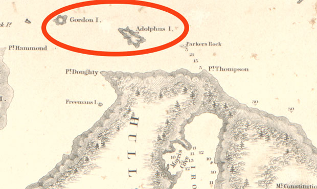
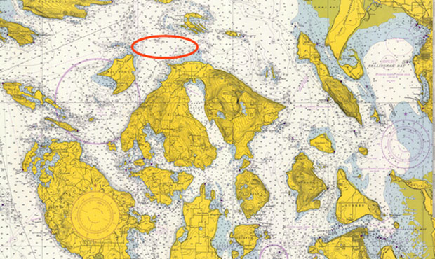
On an 1848 chart published by the US government, two islands -- Gordon and Adolphus -- appear northwest of what's now Orcas Island. (Library of Congress)
What's now the San Juan Islands were envisioned as the "Navy Archipelago" by Naval explorer Charles Wilkes in the 1840s; two "phantom islands" appear on his 1848 chart, just north of what's now Orcas Island. (Library of Congress)
From MyNorthWest by Feliks Banel Special thanks to Mike Vouri and Richard Blumenthal for their research assistance.
The San Juan Islands have long been a favorite summertime destination for tourists from close-by and far away, and many Northwest families are even lucky enough to own a cabin or other vacation property on Lopez, Shaw, Orcas, San Juan or one of the other smaller islands in the chain.
On a U.S. government nautical chart published in 1848, two such smaller islands appear, just north of Orcas, west of the community of Eastsound. Gordon Island is the smaller and western-most of the two, and is maybe a third of a mile long; Adolphus Island is larger, and roughly a mile in length.
This particular chart was the work of U.S. Navy Lieutenant Charles Wilkes and the United States Exploring Expedition. Wilkes led a group of naval vessels on a mission to explore and survey various locations around the world from 1838 to 1842. Members of the expedition spent several months in 1841 in and around what are now Washington waters. In the first half of the 1840s, the Oregon Country was jointly occupied by the British and the Americans, as details – and the international boundary – were slowly negotiated by diplomats in London and Washington, D.C.
Wilkes and company surveying the harbors and inlets here – and naming a lot of geographic features – was a way of making navigation safer, as well as a means of asserting future American possession of what had been Native land for millennia.
While the expedition achieved quite a bit – confirming the presence of a land mass in Antarctica and demonstrating American scientific can-do early in the Republic’s history – those achievements may have come at the expense of Wilkes’ reputation among many of his fellow expeditioners.
Apparently, Charles Wilkes was something of a stern taskmaster, and not
necessarily beloved by the crew who were doing much of the critical
survey work. And, it’s theorized, somewhere along the line, some
disgruntled member of the crew pulled a fast one that resulted in a
major error when Wilkes’ published that 1848 chart.
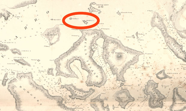
In 1853, American coastal surveyor George Davidson couldn't find any trace of Adolphus Island or Gordon Island where Wilkes' chart depicted them; however, Davidson's account wasn't published until 1858. (NOAA Archives)
The truth is, even though Gordon Island and Adolphus Island appear in print on Wilkes’ official government chart, those two islands simply didn’t exist, and never existed, anywhere besides on paper.
It’s not clear who first noticed the grievous error, but as early as 1853, another U.S. government surveyor – George Davidson, the man who named Fauntleroy in West Seattle after his future father-in-law – must have been among the earliest to figure it out. Davidson wrote about Gordon Island and Adolphus Island in an 1858 Coast Survey publication, observing, “we examined the vicinity and satisfied ourselves that they did not then exist.” Since KIRO Radio couldn’t just take George Davidson’s 168-year old word for it, two local experts were consulted to confirm the real story of the phantom islands.
Both Mike Vouri, former head ranger at San Juan Island National Historical Park and an expert on San Juan Islands history, and Richard Blumenthal, author, maritime historian, and expert on Charles Wilkes, confirmed that they have personally seen — with their very own eyes – and can attest that there are, in fact, no islands where Wilkes’ 1848 chart shows them to be.
How did the phantom islands make it into print, in a chart prepared by someone generally regarded as one of America’s premier surveyors, hydrographers and cartographers?
The Wilkes Exploring Expedition Map (1841).
The "islands" of Adolphus and Gordon are off the northwest tip of Orcas Island.
Map courtesy of Peter Fisher
It may have been that Wilkes was distracted; he had recently learned of the loss of one of the expedition’s ships, the Peacock, at the mouth of the Columbia River. This meant less time to complete the survey work around Orcas Island – or what Wilkes called Hull’s Island, as part of a scheme to name the San Juans the Navy Archipelago, with major geographic features named after officers, ships and famous battles.
Some of Wilkes’ Navy-flavored names remain, such as Mount Constitution on Orcas Island, in tribute to Old Ironsides herself. But distraction may have had only something to do with the error, because at some point in the past – as detailed in 1982 by the late writer and historian John Frazier Henry – suspicion fell on a member of the crew known as Passed Midshipman William May.
There’s no condemning evidence of the alleged hydrographic malfeasance, but there is plenty of proof that May and Wilkes did not get along – famously or otherwise – during the voyage. Wilkes even had May court-martialed not long after the expedition returned to the United States in 1842.
Modern navigation charts, such as this example from 1966, show no such islands as Wilkes had depicted in 1848.
(NOAA Archives)
Localization with the GeoGarage platform (NOAA raster charts)
As for the names of the phantom islands, John Frazier Henry writes that “Gordon” may have come from William Lewis Gordon, a naval office Wilkes had served with earlier in his career. The origins of Adolphus – meaning “noble wolf” – are a mystery. If the error was intended as practical joke, whoever the practical joker was certainly was very patient, as seven years elapsed between survey and publication. If the intention was to somehow embarrass Wilkes, John Frazier Henry couldn’t find evidence that Wilkes was ever made aware of the error, let alone if there was any fallout, professional or otherwise. Bottom line, if you’re one of those unlucky Northwesterners who doesn’t own a getaway in the San Juans, whatever you do, no matter how great the price may be, don’t ever put down money for a cabin on Gordon Island or Adolphus Island.
Boris talks about his heartbreak at the collision and the damage to his boat which occurred on Wednesday 27th at 19:50hUTC while racing in third place, some 90 nautical miles from the Vendée Globe finish line off Les Sables d’Olonne. The boat is damaged on the starboard foil.
The Basque fishermen of Ondarroa in Vizcaya reject any responsibility in the accident that would have cost the German skipper Boris Hermann victory on Wednesday night.
Position of Malizia II Solosailor with CLS on vendeeglobe.fr website before the collision
The navigator was about a hundred kilometers from the finish of the Vendée Globe.
The crew of the Hermanos Busto still can't believe it. During the hake fishing campaign, the 30-meter longliner from Ondarroa (Vizcaya) was hit during the night of Wednesday to Thursday by Boris Herrmann's sailboat 90 miles from Les Sables d'Olonne.
The 15 Basque sailors took a long time to understand what had happened.
"We heard a Boom! We saw that it was a sailboat but we couldn't see anyone," said Aitor Badiola, fisherman and owner of the ship.
And for good reason, the navigator was sleeping.
Hermanos Busto longliner
"We called him on emergency channel 16 and nobody answered! What am I supposed to do?" If the Basque longliner is made of steel and without major damage, they are worried about the consequences on a carbon boat.
You're at a speed of 20 knots, at night, you're sleeping, you hit another boat, and you say it's his fault? Bueno! (Aitor Badiola, fisherman of the hit ship)
The fishing boat tries to reach the monohull "but it continued its trajectory as if nothing had happened, _we thought it was a smuggler's boat!_" recalls Aitor Badiola. Until the moment when they make the connection with the round-the-world race. "I called the maritime rescue services in Spain, then in France, then by going to the Vendée Globe website I read the account of the collision and the coordinates of the accident, it's us!".
We were sad to see that he might have been in a position to win the Vendée Globe and that he would have lost because we had the shock of it, but when I saw the whole thing with the AIS system, damn it! Hey, you're at a speed of 20 knots [37km/h], at night, you're sleeping, you hit another ship, and you say it's his fault?! Bueno...!"
What is certain is that Boris Herrmann was third, and he finished fifth.
In spite of this misadventure, the Hermanos Busto continues its fishing - which is good assures its captain Josu Zaldunbide.
She will return to her home port in Ondarroa on Saturday.


%20Nekton.jpg) Nekton helped President Danny Faure of the Seychelles make a first descent for ocean exploration.
Nekton helped President Danny Faure of the Seychelles make a first descent for ocean exploration.%20Nekton.jpg)
%20Nekton.jpg)