A number of countries have historical claims to land in the Antarctic.
Russia
has insisted it is only in Antarctica for scientific research purposes,
but the discovery of a huge reserve of oil and gas has raised alarm
bells.Concerns are being raised that Russia is prospecting parts of Antarctica for oil and gas and surveying the continent for military purposes amid warnings Moscow could breach a long-standing treaty critical to keeping the region conflict-free.
Russian research ships have already discovered reserves amounting to 511bn barrels of oil – roughly 10 times the North Sea’s entire 50-year output – according to evidence submitted to a committee of MPs.
In a
meeting last week, the Commons Environment Audit Committee (EAC) raised concerns that Russia is carrying out surveys with the view to drilling the region for fossil fuels – which would constitute a breach of the 1959 Antarctic Treaty.
When asked about this by the committee's MPs, David Rutley, a junior minister at the Foreign Office, said that Russia had "recently reaffirmed its commitment to key elements of the treaty", adding: "They have to be held to account on this."
He said Russia has had a "long-standing programme of surveying and mapping the geology of Antarctica both on the land and on the seabed" and has repeatedly given assurances that its surveying is "purely for scientific purposes".
Asked if he was "content to believe Russia" on this, Rutley said: "We continue to monitor the situation and we continue to make our points fully heard... We've had a very successful treaty here. Geopolitical headwinds are challenging, but we need to stick to the course with this."
Antarctica - its scientific value is endless.
What happens there affects us all.
British Antarctic Survey has played an instrumental role in protecting and researching this most vital part of the world.
Why are people concerned by Russia's Antarctic surveys?
In evidence submitted to the committee, Klaus Dodds, professor of geopolitics at Royal Holloway College, said: "There is a worry that Russia is collecting seismic data that could be construed to be prospecting rather than scientific research."
He said this would "signal a potential threat to the permanent ban on mining" and the integrity of agreed-upon environmental protections for Antarctica as a whole.
Activists protest against Russia's polar research vessel, Akademik Alexander Karpinsky, as it enters Cape Town Harbour in April 2023.
(Getty Images)
Professor Dodds added that, that since Russia's invasion of Ukraine, there had been "widespread concern" that Moscow's worsening relationship with the Western world "will spark strategic competition and make it ever more explicit in Antarctica".
The committee also raised concerns over reports by the
Daily Maverick, a South African online journal, which said it discovered Russia's Antarctic activities after its survey ship, the Akademik Alexander Karpinsky, docked in Cape Town.
In an earlier report, it refers to the ship being sanctioned by the US in February over the Ukraine war.
It refers to a statement by the US State Department, which identifies the ship as being operated by PMGE, a subsidiary of Rosgeo.
“Rosgeo and its subsidiaries,” the statement adds, “perform a range of geophysical services in the search and exploration of oil and gas fields. We can confirm this vessel we designated last Friday is owned by a subsidiary of Rosgeo, which is the state-owned oil, gas and mining geological exploration [holding]."
Russia and China 'resisting new protections for Antarctica'In June 2023, the Commission for the Conservation of Antarctic Marine Living Resources (CCAMLR) held a special meeting to try and resolve a six-year impasse in creating further marine protected areas in Antarctica.
China and Russia stalled progress on this by demanding more data, the
Maritime Executive reports, adding that both nations have been blocking proposals to expand Marine Protected Areas since the idea was first proposed by Australia.
Commenting on this pattern in 2022, Tony Press, an adjunct professor at the Institute for Marine and Antarctic Studies at the University of Tasmania, called it a "weird politicisation of science".
Pointing to the threat of climate change in the region, he said: "The use of spurious science to block consensus is a major issue and needs to be dealt with."
In a meeting report, a US delegation said: "We cannot find any rationale for why Russia continues to ignore new data and analyses that disprove its hypothesis and simply conclude that Russia’s approach is intended to sow discontent and crush the spirit of collaboration that many of us share in CCAMLR."
What is the Antarctic Treaty?Signed in Washington on 1 December 1959, the
Antarctic Treaty is a framework designed to ensure peaceful coexistence and scientific cooperation on Earth's southernmost continent.
Antarctica is one of the few places on Earth that hasn't been fought over, and with scientists from 12 countries operating there by the late 50s, it made sense to form an international agreement to keep it that way.
The treaty was ratified by those 12 countries in 1961, but its number of signatories continued to grow and now stands at 56.
Among the 14 articles in the treaty is a resolution that Antarctica shall be "used for peaceful purposes only", with military activities and the establishment of military bases on the continent prohibited.
It protects the "freedom of scientific investigation" in Antarctica, and "cooperation toward that end", and says that "scientific observations and results from Antarctica shall be exchanged and made freely available".
The treaty also ensures that no activities will enhance or diminish previously asserted positions with respect to territorial claims. It also prohibits nuclear explosions and the disposal of radioactive waste.
Out of the 12 nations active in Antarctica at the time the treaty was signed, nine had made territorial claims over the continent or had reserved the right to do so.
However, all parties agreed that their political differences shouldn't interfere with research on the continent, and as a disarmament regime, the treaty has helped to prevent any territorial disputes.
source : According to the British newspaper The Telegraph, Russia has reportedly discovered the largest oil reserves in history in British waters off Antarctica, despite hydrocarbon exploitation in the region being strictly prohibited, except for specifically authorized scientific activities.
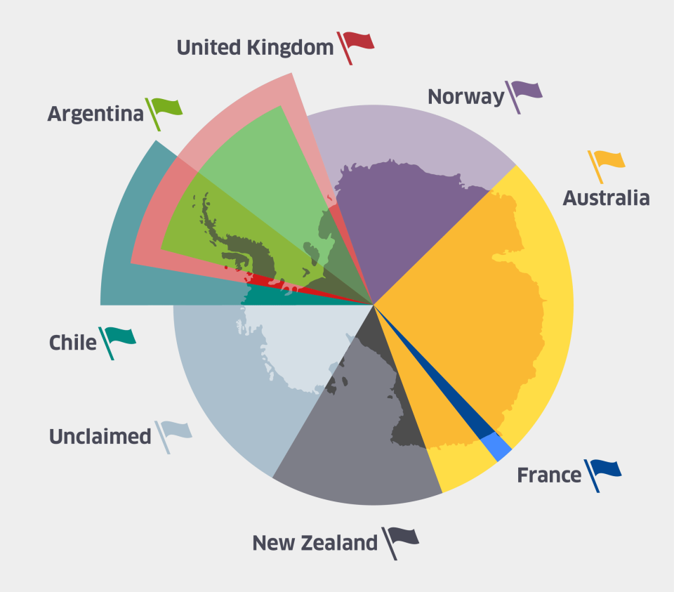
Which countries have claimed territory in Antarctica?
The international partnership ensures that no single country "owns" Antarctica, although seven countries do have historical territorial claims over the continent.
Argentina, Australia, Chile, France, New Zealand, Norway and the United Kingdom maintain territorial claims in Antarctica, which were made as expeditions began to explore the continent.
Most countries, including the United States, do not recognise these claims, according to the US Department of State.
While neither the US nor Russia have made claims over the continent, both nations reserve the right to do so.
There is still an unclaimed section on the southwest of the continent, but many other countries including Italy, Japan, China, the US, Russia, India, Pakistan, South Africa and Poland have built research facilities in areas claimed by other nations – another example of the spirit of cooperation that has kept conflict away from Antarctica so far.
Links :
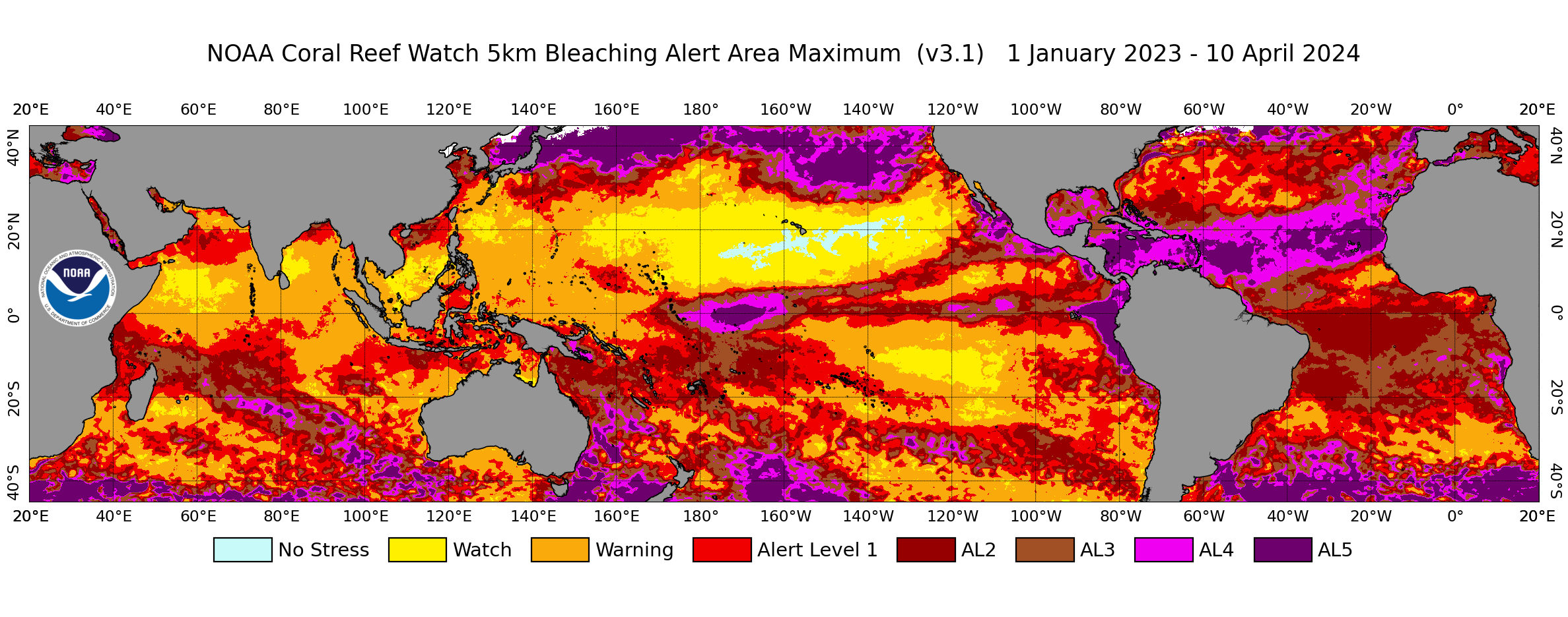 NOAA Coral Reef Watch's global 5km-resolution satellite Coral Bleaching Alert Area Maximum map, for January 1, 2023 to April 10, 2024.
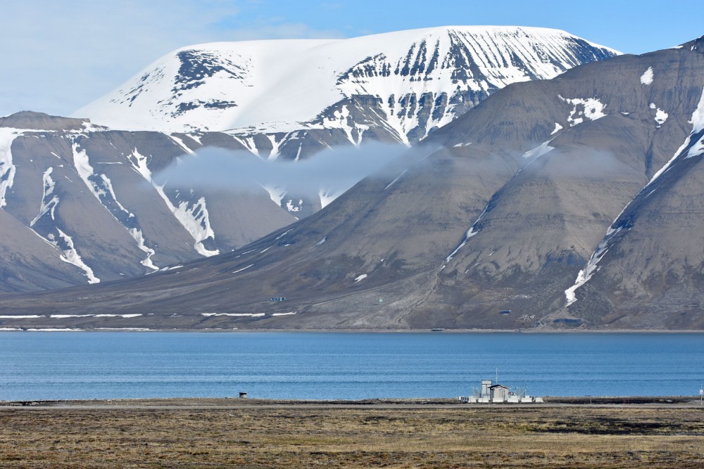


 Svalbard is Norwegian territory. About 60% of the land is covered by glaciers.
 photograph: bridgeman