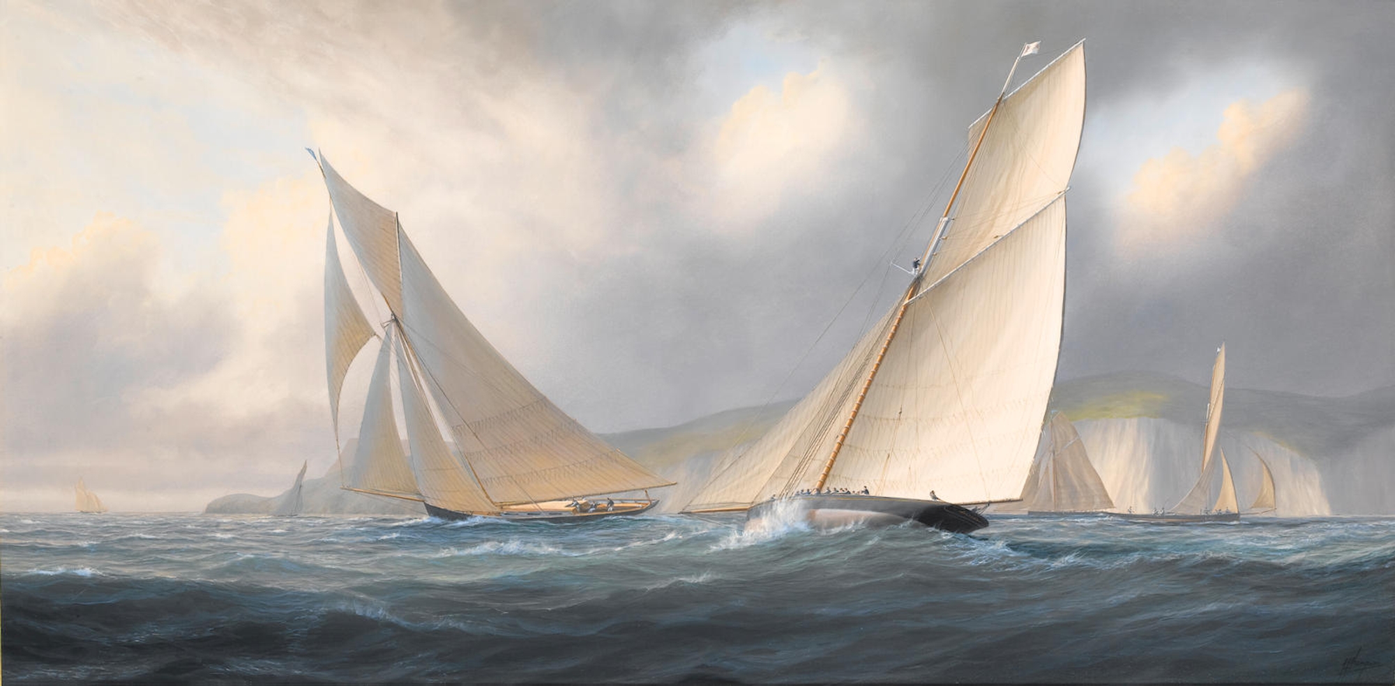
From IHO In 1741, the English Empire carried out a large-scale attack against Cartagena de Indias.
To defend the city, the commanding officer Admiral Blas de Lezo strategically sunk several warships to form a line of defense and led the Spanish to ultimate victory.
Through an analysis of historic documents and cartography, complemented with acquired field data, it was possible to locate and identify four anomalies that are, compatible with the warships, Conquistador, Dragón, África and San Carlos.
This study contributes to defining conservation and preservation strategies of submerged cultural assets, a topic which Colombia must develop in the future.
1. INTRODUCTIONScientists investigate wrecks, in order to understand different cultures over time and the best way to preserve these sites (Lumb et al., 2006; McCarthy, 2015; Parrent, 1983).
Nowadays, submerged stories can be reconstructed using equipment that does not interfere with the wrecks but capable of showing vestiges of the past (Ballard et al., 2011; Quinn, 2006; Westley et al.
2019; Andrade, 2021).
This is the case in our study, which seeks to describe four shipwrecks associated with an important event in the Cartagena Bay history of the eighteenth century.
UNESCO has designated “Cartagena de Indias” as a World Heritage Site due to its relevant historical assets.
These include the remains of colonial and industrial shipwrecks, fortresses walls (e.g., the fort of San Luis de Bocachica) and colonial architectural and civil works (Guzmán- Martínez et al., 2022) in the bay.
An example of the later is the “Escollera”, a submerged wall built in the sixteenth century to close the Bocagrande entrance to the bay (Borrero-Londoño & Andes, 2011; García-Castrillo et al., 2003).
Therefore, it is crucial to assess the history behind each of the different artifacts found in the bay’s seafloor, to better understand historical facts that can elucidate processes from the past, which helped to build today’s Colombian society.
In this paper, we assess the present condition of four shipwrecks with archeological interest in the Cartagena de Indias Bay.
We identified four anomalies compatible with the shipwrecks África and San Carlos in the Bocachica Channel, and Dragón and Conquistador, in the Internal Bay en- trance (Figure 1), all sank by Admiral Blas de Lezo during the 1741 battle against invading English troops.
General information related to this historical event is presented in the rest of this section.
In Section 2, we describe the study area, and describe the environmental variables, which have affected these wrecks for ~280 years.
In Section 3, the methodology used is mentioned, followed by the main results in Section 4.
Finally, in Section 5, summary and final remarks are presented.
1.1 Cartagena de Indias historical BackgroundCartagena was known in the sixteen and seventeenth centuries, as an important port under the domain of the Spanish crown.
Particularly in colonial times, Cartagena, was considered a strategic site, called by the British empire as “The Key to the Indies”.
Its strategic location favored regional trade and its defense from constant siege of pirates who wanted to assault the city (Colombian Caribbean Figure 1).
To protect Cartagena, a military strategy at different levels was developed over time.
Figure 1: Nautical chart of the Cartagena Bay #216 and the Greater Caribbean #007 from DIMAR-CIOH-SHN.
Cartagena with the GeoGarage platform (CIOH map)
The first protection level was a natural one.
It was associated with its tropical location and closeness to the sea, which acted as a first line of defense.
Environmental aspects such as temperature, humidity and mangrove wetlands in the coastal areas, act together with insects and other organisms present in the region, creating a harsh environment unfamiliar to Europeans (Del Cairo-Hurtado, 2014).
A second stage consisted in building defenses to protect the city from maritime attacks.
The Bocagrande entrance suffered different morphological changes during the colony, which closed and opened the channel in different periods (Andrade et al., 2004; Gómez-Pretelt & Carvajal-Díaz, 2011; Vernette et al., 1984).
To stabilize this dynamic place, the Spaniards constructed a submerged wall (Escollera) with the strategic military purpose of closing that warships entrance into the bay, but maintaining a shallow water exchange with the Caribbean (Andrade et al., 2004).
The construction of “La Escollera”, which still exists, forced the entrance of large warships through the Bocachica Channel, the southern and deeper entrance to the Bay.
This facilitated the defense strategy, as only one and narrow access into the bay had to be protected.
Besides, the maritime defense of the bay was complemented by a fleet of warships under the Spanish flag (De Lezo, 1741).
The third stage of the Spanish strategy consisted of the inland defense of the city.
In the case of troops landing in the surroundings of Cartagena de Indias, due to the wetlands present at the time, they were forced to use the only terrestrial access to the city, which was protected by the San Felipe Castle.
Besides, walls with batteries and other means of defense surrounded the city.
1.2 1741 historical events
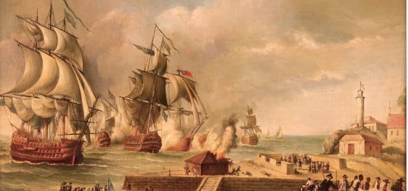
Figure 2: British Attack in Bocachica – Defense of Cartagena de Indias by Blas de Lezo.
Fragment Picture made by Luis Fernández Gordillo 1994, Naval Museum of Madrid.
The English Admiralty set Cartagena as a target in 1739, to break the flow of resources to the Spanish Empire from its colonies in “Tierra Firme”.
This led to, the Cartagena of Indias siege by an English squadron, of more than a hundred warships, in 1741, under Vice Admiral Edward Vernon command (Del Cairo-Hurtado, 2014; García, 2001; Suárez, 2015) (Figure 2).
Information about the 1741 battle is depicted in the Cartagena de Indias map (Figure 3), presented to Edward Vernon, Vice Admiral of the Blue, and Commander-in-Chief of Her Majesty’s warships in the West Indies, by Captain Phil Durrell (1741).
This map indicates fundamental facts for the description and analysis related in the results of this paper.
As the battle evolved, the English advanced overcoming the Spanish land defenses, in the Bocachica Channel.
Once the warships were inside the bay, they tried to enter the Internal Bay to disembark the troops close to the city.
Admiral Blas de Lezo, commander of the Cartagena defenses, ordered first the deployment of Spanish warships to the Bocachica Channel to stop the English warships entrance into the bay.
After the English vessels were able to enter the bay, Admiral Blas de Lezo attempted to block the entrance to the Internal Bay (protected by the forts of Santa Cruz de Castillo Grande and San Juan of Manzanillo).
In his intention to block the English vessels approximation to the city, Admiral Blas de Lezo ordered his troops firstly to sink some warships in the Bocachica Channel, and later in the Internal Bay entrance.
Admiral Blas de Lezo (Spanish version), in his diary narrated events that occurred during the 1741 battle in the Bocachica sector.
He mentions that in March 14, he ordered his troops to prevent enemy warships from entering to the Cartagena Bay (De Lezo, 1741, p. 9).
On April 5, after different confrontations, The San Felipe and África were set on fire, ordering the crews to return to the city, and sink them in the colonial channel (IHCN, 2021, p. 248; De Lezo, 1741, p. 33).
Admiral Blas de Lezo (1741), narrates a meeting that took place on April 9, 1741, at the house of Don Sebastián de Eslava, viceroy of New Granada.
In this meeting it was discussed the convenience of sinking the Spanish warships, with the intention of closing the access channel to the inner bay, since they could not withstand the enemies’ attacks (De Lezo, 1741, p. 37).
They agreed to sink all the boats and warships still available in a straight line from Castillo Grande to the Manzanillo Island to close the access through the channel.
“Conquistador” and “Dragón”, as well as other smaller warships had to face this fate.
Finally, the battle of 1741 that started the 13th of March, ended the 20th of May with the victory of the Spanish crown, as the English could not take the city, being forced to abandon the bay (Del Cairo-Hurtado, 2014; De Lezo, 1741; Suárez, 2015).
Admiral Blas de Lezo defense of the city was so successful.
1.3 The warships
The Spanish warships constructed in serial production during the 18th century, were the largest and most important of the European fleets, intended for naval combat (Aldana, 2019; Apestegui, 1984; De Eslava,1741; De Lezo, 1741; Rodriguez-Mendoza, 2008).
This type of vessels was part of the fleet under De Lezo command during the defense of Cartagena.
The fleet consisted of six serial large warships: Galicia, San Felipe, Conquistador, Dragón, África and San Carlos (De Lezo, 1741).
In addition to these warships, his fleet also had some sloop and brig type boats, smaller in size (De Lezo, 1741).
For the 18th this century, these warships suffered constant revisions related to the naval architecture specifications, which were in accordance with the organization of their shipyards.
José Antonio de Gaztañeta, a military engineer, in 1712 wrote the “Proposiciones de las Medidas Arregladas a la construcción de un Bajel de Guerra” as indicated in Hormaechea et al.
(2018), summarizing these guidelines and directives to build the Spanish warships (Table 1 outline findings on the vessels).
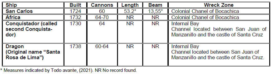 Table 1: List of four Spanish shipwrecks involved in the 1741 battle in Cartagena Bay (Aldana, 2019; Beatson, 1804; Boado & Gonzáles-LLanos., 1983; De Eslava, 1741; De Lezo, 1741; Quintero-Saravia, 2002; Suárez, 2015; Todobabor, 2003; Rahn Phillips, C. 2010; Hormaechea et al., 2018).
2. DESCRIPTION OF THE AREA AND ENVIRONMENTAL CONDITIONS
The Cartagena Bay, is influenced by the northern trade winds and by the oscillations of the Inter- tropical Convergence Zone – ITCZ.
The meridional fluctuation of the ITCZ generates a marked seasonality defining a dry and rainy season.
The Bay is an estuarine ecosystem influenced by freshwater contributions from the Dique’s canal.
The Bay is connected to the Caribbean Sea by the Bocagrande and Bochachica entrances (Section 1.2).
Most of the seawater enters from the Caribbean Sea into the bay through the Bocachica sector, due to the presence of a deep channel (Grisales et al., 2014; Tosic et al., 2019).
The increase of the freshwater input from the Dique´s canal, generate strong vertical density gradients and sea level increase (Molares & Mestres, 2012; Pagliardini et al., 1982; Rueda Bayona, 2010; Torres & Tsimplis, 2012).
The city has a significant relative mean sea level trend, which is higher than in other coastal stations studied in the region (Torres-Parra & Tsimplis, 2014).
This trend is expected to increase in the future as a consequence of global warming (Bustos & Torres, 2021).
3. DATA AND METHODOLOGY
3.1 Description of potential warshipwreck location based on historical sources
Firstly, a cartographic revision of historical maps of the 1741 battle, that took place in the Cartagena Bay was carried out.
For this search, databases of Oshermaps, International Hydrographic Organization, Banco de la República de Colombia and Gallica were consulted.
Additionally, historical texts describing these events were reviewed, some showing the Spanish perspective and others with the English point of view.
An example of the former is the diary of Admiral Blas de Lezo (1741), while for the later, a chronicle narrated by Beatson (1804).
We want to highlight the map by Phil Durell (1741), in which the Cartagena Bay can be fully observed (Figure 3), showing its connection to the Caribbean Sea from Bocachica and Bocagrande.
Besides, the map shows the location of the main forts, as well as details on the Spanish and English
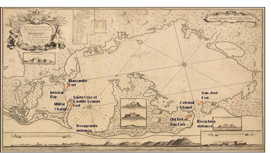 Figure 3: Map of the Cartagena of Indias battle, by Captain Phil Durell (1741).
3.2 Characterization of wrecks using multibeam echosounder- MBES, side scan sonar -SSS and underwater photographs
Hydrographic campaigns were carried out with a Kongsberg 2040C high resolution multibeam echosounder system (MBES), in two sectors of the Cartagena Bay, the Military Channel giving access to the Internal Bay and Bocachica, as the only entrance to the bay for large warships.
This research was carried out following the guidelines indicated by Westley et al.
(2019), for the optimization of this kind of hydrographic surveys.
At each site, when anomalies compatible with cultural artifacts were found, the survey lines were densified.
We were able to search for objects on the seabed, with a resolution of 3 cm, using a 400 kHz frequency.
This data was processed and analyzed through the CARIS Hips and Sips software.
MBES data was complemented with a detailed seabed survey, using a Kongsberg Pulsar 200 side scan sonar (SSS), where cultural remains were identified in the bottom of the bay.
Detailed characteristics of each anomaly were obtained, in terms of their acoustic response.
Approaches from different directions were performed to find the best image of the cultural remains detected, setting the equipment at a high frequency (400 to 600 kHz), which reduces the range, but improves the resolution.
The horizontal detection range was adjusted to 75 m for the survey at both sites.
Images processing, the analysis of targets and distance measurements were carried out with the Hypack software version 2020.
Besides, shipwrecks were identified using as criteria the remains ’ shape, dimensions (length and beam) and the presence of cultural anomalies identified in their surroundings.
To photograph the cultural anomalies identified, inspections were performed through autonomous diving at the two surveyed sites.
Underwater inspections were carried out in September 2020.
However, the turbid water conditions in the Cartagena Bay due to the Dique´s canal freshwater and sediment flow, made it difficult to achieve an optimal photographic record (Section 2).
Thus, in the Bocachica area, it was not possible to obtain good images of the wrecks ’ sites.
In the Inner Bay entrance, only photos could be recorded in one of the wrecks.
This technique offers many advantages registering archaeological sites; however, it is always subject to the environmental visibility conditions at the place of interest.
4. RESULTS AND DISCUSSION
4.1 Shipwreck identification from historical documents
Twelve maps were found with the description of the 1741 battle.
Of these, only four maps are presented in this article Each map represents a valuable source of information that allows identifying aspects such as the names and flag of the warships, as well as their conditions during the battle.
The ship’s conditions include if it was sailing, largely damaged, sunk, or set on fire during the confrontation.
The cartography of the time clearly identified other geographic aspects such as shallows, the depth of the bay and the location of Spanish forts.
This information facilitates the understanding of the military strategy used during the battle, the development of events narrated by written sources, environmental characteristics affecting the battle, among other factors.
However, in this article, we focus on the description of events in Bocachica and the Internal Bay sectors, respectively (Figure 4 and 5).
Bocachica (Colonial Channel) in the 1741 battle.
In the Chassereau & Bowles (1741) map (Figure 4a), the position of two forts, San José, and San Fernando can be seen in Bocachica, as well as the location of África, San Carlos and San Felipe warships, already inside the Bay.
The Bellin (1763) map shows the location of three shipwrecks in the colonial channel, represented one to the side of the other (Figure 4b).
Durell (1741) indicates the English “Le Stock” Division in blue, an English supply ship in yellow and with the crossed line the position of two shipwrecks in the area (Figure 4c).
This map locates the Fort of San Luis, which was attacked and destroyed in the 1741 battle (Del Cairo-Hurtado, 2014), being later replaced by the Fort of San Fernando de Bocachica.
Parr (1741) included some nomenclature in his map; the letter P refers to the place where África and San Carlos warships sunk, which were drowned by their masts above the seawater (Figure 4d).
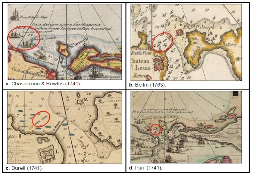 Figure 4: Comparison of maps in the Bocachica channel sector indicating military actions that occurred during the battle of 1741.
In the Chassereau & Bowles (1741) map, the place where Conquistador and Dragón warships were sunk is identified by their masts above the water level (Figure 5a).
Their position indicates the Spanish intention to obstruct the channel with a barrier formed by the sunk warships.
Similarly, Bellin (1763) highlights the shipwrecks line preventing the entrance of English warships to the internal bay, as part of Admiral Blas de Lezo’s defense strategy (Figure 5b).
This map also clearly shows the location of the two access channels to the Internal Bay.
The Military Channel is located adjacent to Santa Cruz Fort toward the south of the map.
Durell (1741) differentiates the fleets with colors.
In red Admiral Vernon ’s division, English supply warships in yellow and shipwrecks in the area represented with crossed lines (Figure 5c).
The two channels allowing the entrance to the internal bay are also distinguished in this map.
Note that the number of sunken warships is different when comparing the Bellin (1763) and Durell (1741) maps, which indicates the doubt in the English side about the total number of sunken warships in this sector.
In Parr’s (1741) map, Conquistador and Dragón names are shown at the side of the drawing of two warships; besides, he highlights the sunken warships symbolized with their masts above the water (Figure 5d).
It is important to note that the intention of this map is to present the military tactics and it inspires the map of Chassereau & Bowles, (1741); therefore, it narrates details of the 1741 battle in different locations, which are indicated with letters.
In support of the information obtained from the historical cartography, the writings of the time that describe the 1741 battle, complemented the information related to the sunken Spanish warships.
In Beatson (1804, p. 96) narration (English version), mentions the presence of África, San Carlos, San Felipe, and Galicia warships, in the Bocachica sector at the beginning of the battle, to defend this entrance against any attempt of English warships to enter the bay.
Beatson mentions that, because of a strong attack, África and San Carlos warships were sunk in deep waters of the colonial channel (Bocachica).
Different sources of information indicates that the Galicia was captured (De Eslava, 1741, p.14), while a recent research indicates that the San Felipe was set on fire (Aldana, 2019).
This documentary information matches the shipwrecks positions depicted on the battle maps (Figure 4).
As indicated in Admiral Blas de Lezo diary (Lezo, 1741, p. 37), the Spaniards worked all day creating the blockade line.
He gave the order to remove artillery elements from Dragón ship, to fortify the inland defenses.
Due to the lack of large warships, he sunk two sloops and a brig.
In support of the information obtained from the historical cartography, the writings of the time that describe the 1741 battle, complemented the information related to the sunken Spanish warships.
In Beatson (1804, p. 96) narration (English version), mentions the presence of África, San Carlos, San Felipe, and Galicia warships, in the Bocachica sector at the beginning of the battle, to defend this entrance against any attempt of English warships to enter the bay.
Beatson mentions that, because of a strong attack, África and San Carlos warships were sunk in deep waters of the colonial channel (Bocachica).
Different sources of information indicates that the Galicia was captured (De Eslava, 1741, p.
14), while a recent research indicates that the San Felipe was set on fire (Aldana, 2019).
This documentary information matches the shipwrecks positions depicted on the battle maps (Figure 4).
As indicated in Admiral Blas de Lezo diary (Lezo, 1741, p. 37), the Spaniards worked all day creating the blockade line.
He gave the order to remove artillery elements from Dragón ship, to fortify the inland defenses.
Due to the lack of large warships, he sunk two sloops and a brig.
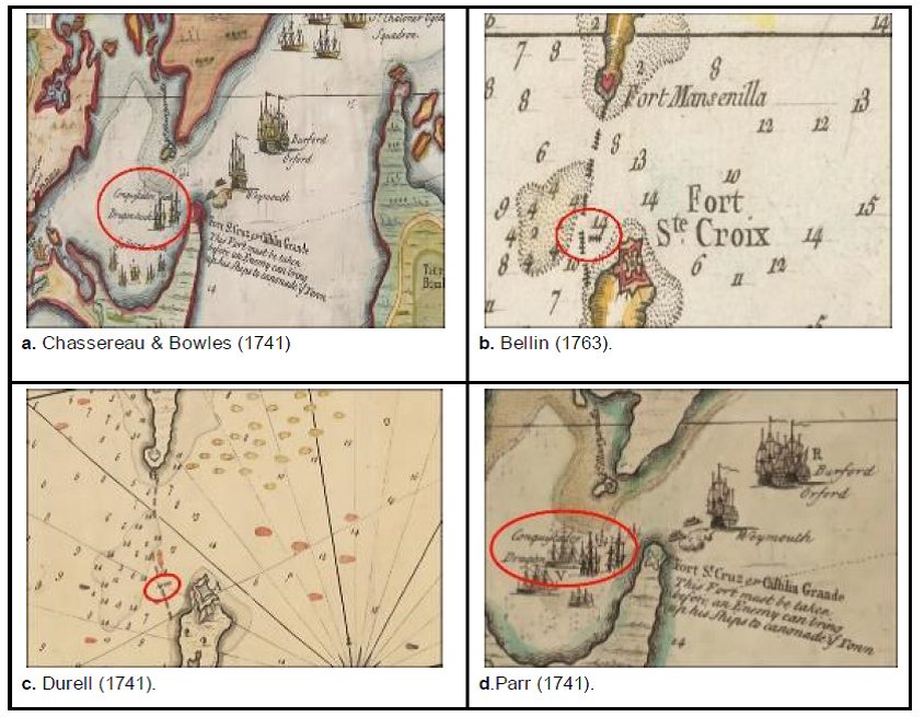 Figure 5: Comparison of maps in the access zone to the Internal Bay indicating military actions that occurred during the battle of 1741.
The movement of the Conquistador’s was also mentioned by De Lezo (1741) and De Eslava (1741).
They mentioned that this ship did not sink completely, allowing the Englishmen to tow it toward the southern side of the Military Channel.
As consequence of this movement, the Conquistador shipwreck can be differentiated from other wrecks, as finally, it was not placed in the straght line closing the Military Channel (De Lezo, 1741; Figure 5c).
The shipwrecks position from the 1741 Battle was confirmed by the historical documents review.
Of the six major Spanish warships that participated in the battle, África and San Carlos were sunk in the colonial channel.
Additionally, San Felipe shipwreck has been identified in shallower waters from the Bocachica area (Aldana, 2019; Del Cairo-Hurtado, 2014).
We do not further assess this shipwreck, as its description is part of another study.
In addition, we have shown evidence that Dragón and Conquistador warships were sunk during the battle in the channel that gives access to the interior bay of Cartagena de Indias.
The latter, ended in a different position than other sunk- en warships in this sector, as it was towed by the English to recover access to the internal bay.
Note that the sixth large ship, the Galicia, was reported as captured (De Lezo, 1741), and no evidence of his shipwreck has been found in the study area.
To identify the current location and conservation level of the África, San Carlos, Dragón and Conquistador shipwrecks, in the following Section 4.2 we describe the results of a survey performed to the study area.
We used a multibeam echo sounder and side scan sonar, to evaluate the existence of anomalies in the bottom of the bay, with characteristics that could match those from a ship of that time, looking also for nearby cultural elements that could be related to the warships from the 1741 battle.
4.2 Hydrographics results
We focused on the recognition of anomalies in the survey results performed using geophysical sensors when their characteristics could be related to elements of cultural interest.
This information allowed us to identify their location, context, dimension, among other characteristics.
This was possible as the sensors used were programmed to obtain high spatial resolution data, so that the greatest number of details could be identified (Westley et al., 2019).
High resolution bathymetric surfaces of the access to the Internal Bay (Military channel) and Bocachica (Colonial Channel), were produced using the multi-beam echosounder system (hereinafter MBES) survey.
Five anomalies were detected protruding from the bay ’s seafloor: two in the Military Channel and three in the Colonial Channel.
No evidence of other shipwrecks was found in either sector.
Results from our geophysical survey were compared with the Durell’s map, (Figure 6 and 7) finding a good coincidence in the location of the shipwrecks.
This result is also consistent with the historical information presented in Section 4.1.
We assessed the depth at which each anomaly remains using the bathymetric surface we produced and compare these results with the depths shown in the Durell’s map (Table 2).
Although the depth comparison has a margin of uncertainty regarding the measurement method, units and instruments used, we found a good agreement in the four anomalies assessed.
Note the close position of the shipwrecks (anomalies) to the deepest zones of the Colonial and Military channels in both sources.
We assessed the shipwrecks in the Military Channel which gives access to the internal bay.
The layout of the shipwrecks’ position is indicated in the cartography of the time (Figure 6a).
Most of the sunken warships are perpendicular to the Military channel, except for the one that was recognized as the Conquistador in the documentary review.
This ship is placed parallel to the channel, after being towed by the English to recover access to the internal bay (Figure 3).
Two anomalies are seen in the bathymetric survey (Figure 6b).
The anomaly indicated with number 1 corresponds to Conquistador, while the anomaly indicated with number 2 corresponds to Dragón, based on the documentary assessment presented in Section 4.1.
The bathymetric data shows Conquistador closer to the southwest coast, when compared to the position shown by Durell (1741).
This difference is probably consequence of a normal cartographic error given the lower precision achieved by the maps of the time.
However, from a tactical-military point of view, the Conquistador ship was probably towed toward the shallower waters on one side of the channel, to recover the ship’s transit through it.
Following the same line of thought, as Dragón was a larger vessel when compared to the sloops and brigs.
Therefore, it was probably sunk in the deepest part of the military channel, which corresponds to the place of the anomaly shown in Figure 6b.
Consequently, we believe that the anomalies identified in the Military channel bathymetric survey, corresponds to the current position of Dragón and Conquistador remains.
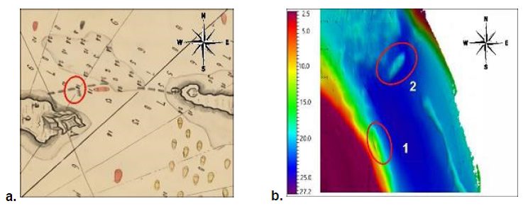 Figure 6: Comparison of the defense line of Admiral Blas de Lezo, between historical cartography and the results found in this project in the access zone to the internal bay, Military channel sector.
a. Map of Durell (1741).
b. Bathymetric surface collected in this study with MBES.
We assessed the shipwrecks in the Colonial Channel that gives large warships access to the Cartagena Bay.
The area surveyed with the MBES is shown in the Durell’s (1741) map with a black square (Figure 7a).
From the three anomalies seen in our bathymetric survey, only two will be described in this study.
Based on the description from Arebalo (1758) we identified África and San Carlos warships, which are shown in Figure 7b with the numbers 3 and 4 respectively.
The third anomaly corresponds to the San Felipe ship, whose position is indicated with an asterisk in Figure 7b and coincides with the position previously reported by Aldana (2019) and Del Cairo (2014).
The bathymetric anomalies have the same orientation as the shipwrecks shown in the Durell’s (1741) map (Figure 7a) and are placed in the deeper part of the channel.
However, in this map, the shipwrecks seem to be closer to the coast at their west and a deep channel observed at the southern side of the bathymetric survey is not visible in the map (Figure 7a).
This is the first time to see this connection using MBES.
Based on a comparison of data from 1735 and 2011, Andrade et al.
(2017), found that the coastline of the Tierra Bomba and Abanico islands, the latter in the southern side of the map (Figure 7a), have changed, producing a land reduction of 342 hectares, specially affecting Abanico Island.
Shallower areas adjacent to the Colonial Channel were indicated in Durell’s (1741) map with shaded areas (Figure 7a) and identified in the bathymetric survey with depths <15 m (Figure 7b).
In the southern zone of the bathymetric plane, a channel with >20 m of depth is observed, which is not shown in Figure 7a.
This anomaly corresponds to the current deep navigation channel, dredged to facilitate the entry of larger warships to the Cartagena Bay, which did not exist in 1741.
Therefore, we believe that the bathymetric anomalies in Figure 7b show the current position of the África and the San Carlos warships in the Colonial Channel (northwest of the bathymetric survey).
Note that this was the only channel that allowed larger warships to sail into the Cartagena Bay at the time of the 1741 battle a condition that is recognized in the channel’s name.
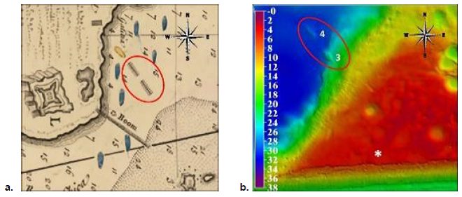 Figure 7: Comparison of the defense line, colonial channel sector in Bocachica, between historical cartography and the results found in this project.
a. Map of Durell (1741), with a triangle indicates Isla Abanico and with a circle the island of Tierra Bomba; the black box shows the area surveyed with MBES.
b. Bathymetric surface collected in this study.
The dimensions of the four anomalies mentioned were estimated from the multibeam data, as indicated in Table 2, to compare them with the characteristics of the warships of the time, described in Section 1.3.
We found that the measurements of the anomalies are compatible with the dimensions of Spanish warships of the 18th century.
However, measurements seem to be smaller, especially in the warships’ length.
These differences may be related to each site formation process, warships variations suffered during the combat and their sinking, materials disintegration, and modification over time from environmental interaction or even because some buried elements might exist under the seafloor, which were not detected with the methodology we used.
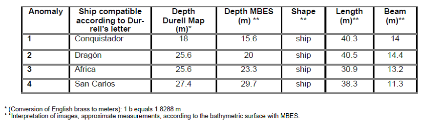 Table 2: Characterization de anomalies ubicated in the line of defense.
4.3 Description of the state of the shipwrecks and elements of the cultural context
We followed the shipwrecks classification proposed by Gibbs (2006), and tried to determine the existence of attributes that could be related to a colonial ship.
These aspects include the presence or absence of cargo (e.g., fabrics, ceramics, among others); nautical or war accessories (e.g., chains, anchors, masts, cannons, etc.); and / or warships’ main structure such as the hull.
After the main anomalies were detected with the MBES, a side scan sonar (SSS) was used to identify the presence of discrete and smaller elements close to each anomaly.
The interpretation of these images is based on the acoustic response of the different materials.
The darker areas indicate the presence of sediments, while the lighter areas indicate the presence of hard elements.
The sediments dynamics in the bay is an important issue to consider, given that the MBES and SSS results indicate a different sediment coverage in each anomaly.
Anomalies in the Military Channel (1–2) were the least covered by sediments, while anomalies in the Colonial Channel (3–4) were more covered by fine sediments.
The sediment coverage of the shipwrecks corresponds to their proximity to the Dique’s canal mouth.
We continue below with a more detailed description of the anomalies listed in Section 4.2.
First anomaly – “Conquistador”: It lays in the Military Channel, which gives access to the internal bay.
Its shape is compatible with a ship’s hull.
The orientation of the bow is toward the deeper side of the channel (blue triangle), while the stern is placed on the channel’s slope (red triangle).
Figure 8a shows the anomaly in the MBES survey.
Figure 8b shows the response to the SSS, where a series of scattered elements around the ship are identified.
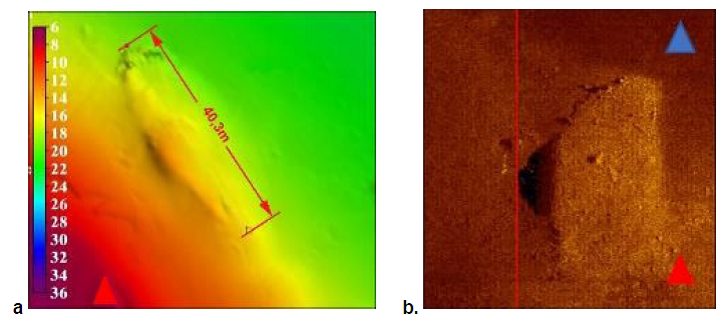 Figure 8: Characterization of the anomaly one using identification with MBES ( a.) and with SSS (b.)
Through autonomous diving, the elements detected by the sonar were inspected.
The presence of organic material (e.g., wood) and inorganic material (e.g., ballast rocks) at the site of the first anomaly could be photographed (Figure 9).
It is important to clarify that this kind of material is not proper of the seabed.
These shipwrecks remains have been studied by authors such as Del Cairo & García Chaves (2006), García, (2001) and Martín et al. (2021).
All coincide that this remains are from the Conquistador.
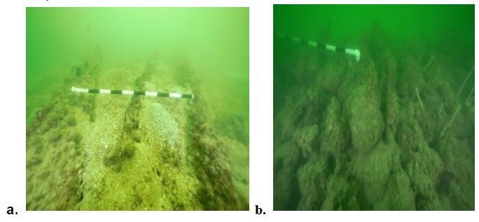 Figure 9: Analysis of the natural context of the conquerin g ship, presence of organic materials.
Photos: Santiago Estrada-DIMAR-PRNPCS-2020.
a. Wooden hull remains. b. River rocks used for ship ballast.
Measuring ruler with black and white segments, each 10 cm long.
Second anomaly – “Dragón”: It lays in the Military Channel, which gives access to the Internal Bay.
In the MBES survey, the shape of a ship’s hull perpendicular to the deeper part of the channel is observed with light blue (Figure 10a).
The SSS image shows the wooden hull protruding from the bottom with elements visible on both sides.
The shaded short lines on the remains of the hull (Figure 10b), correspond to at least ten cannons.
Due to poor visibility conditions, good photographs could not be obtained through diving.
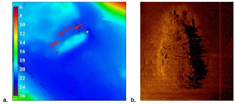 Figure 10: Anomaly recognition two: Internal bay sector, Military channel.
Identification with MBES (a.) and with SSS (b.).
Third Anomaly – “África”: This anomaly lays in the Colonial Channel – Bocachica sector.
The MBES survey shows a shape of a ship’s hull with 30.9 m of length, protruding from the bottom at ~24 m deep; as consequence of higher sedimentation rates, objects with anthropogenic nature detected by the SSS do not have a distinguishable shape (Figure 11b).
It was not possible to take images through diving due to the lack of good visibility conditions.
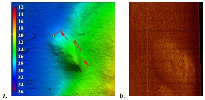 Figure 11: Anomaly recognition three: Bocachica sector.
Identification with MBES ( a.) w ith SSS (b.).
Fourth anomaly – “San Carlos”: It lays in the Colonial Channel, sector of Bocachica.
This anomaly does note emerge as clear as the other anomalies from the bottom, however the ship ’s hull shape is still evident (Figure 12).
Besides, it is possible to identify in the SSS image, the presence of some elements ~2 m long of anthropogenic origin, however, due to sedimentation, the acoustic response is not clear enough as to identify the type of cultural elements observed.
Due to visibility conditions, it was not possible to take images of the site through diving.
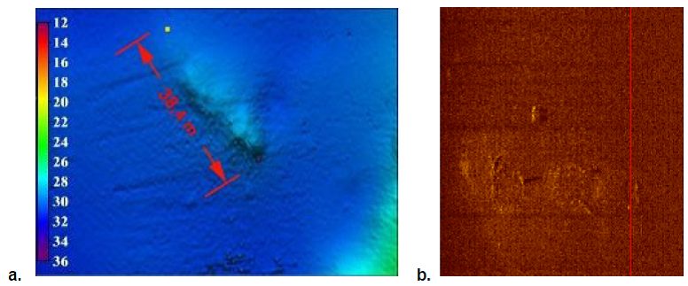 Figure 12: Anomaly recognition four: Bocachica sector.
Identification with MBES (a.) and with SSS (b.).
As recommended by Gibbs, (2006), the description of the in-situ context through the MBES survey, side scan sonar images, and underwater photography, allowed us to determine that the four anomalies are compatible with warships for 1741.
This result is based on the evidence indicating the presence of elements of anthropogenic nature such as cannons and remains of the main structure, such as the warships’ hulls.
It was also identified that although 280 years have passed, the contexts studied in this study around each anomaly can be classified as “intact” contexts, since the material is found in the same area with a coherent distribution (Stewart, 1999; Bass et al.,1982).
However, it is important to clarify that, despite this aspect, each shipwreck is in permanent interaction with the environmental dynamics at the site.
5. SUMMARY AND FINAL REMARKS
For the first time four shipwrecks from the 1741 battle in the Cartagena Bay are carefully identified and described to see the connections between the shipwrecks.
The methodology used in this work combined the study of documents of the time and the use of equipment such as the MBES, SSS and visual inspections, allowing us to find evidence of the events that occurred in 1741.
Furthermore, the visual inspections through diving, although limited by the visibility conditions, allowed us to record elements of anthropogenic nature that do not correspond to the marine environment, which were associated with colonial vessel.
Therefore, for this type of analysis we recommend the integration of the cartographic and documentary assessment with geophysical measurements.
The position of the four warships detected in the geophysical measurements, corresponds to the documentary information of the 1741 battle.
Additionally, the first anomaly, which is related to the warship Conquistador, shows a wooden hull and ballast stones, which were photographed, as well as cannons, distinguished through the SSS.
This anomaly has a pattern, location and position that coincides with Durell’s (1741) description.
The second anomaly position is related to the remains of the Dragón, resting at the bottom of the Military Channel.
In this site, cannons and a large amount of dispersed anthropogenic material can be seen.
The characteristics of these two anomalies corresponds to the events described by the Admiral Blas de Lezo 1741.
The third anomaly, which is compatible with África shipwreck position, shows a covered wooden hull where cannons are identified protruding from the bottom.
The fourth anomaly is related to the position of the remains of San Carlos shipwreck, resting at the bottom of the Colonial Channel.
The position of these two anomalies corresponds to the events narrated in the Bocachica sector during the 1741 battle, as indicated in the historical cartography and documents of the time indicated in Section 3.1.
In this sector, shipwrecks suffer from a higher rate of sedimentation due to its proximity to the Dique’s channel, which has possibly covered other cultural elements associated with the warships remains.
For Colombia, it is important to preserve the submerged history of the colonial period that is related to the four shipwrecks remains described in this study.
Any conservation strategy begins with an adequate identification of the position of the shipwreck and its associated cultural elements, as well as by understanding the environmental context of each site, as was assessed in this document.
Based on this kind of information, the next step is to define conservation and dissemination strategies, a topic on which Colombia must work in the future.


