Dr. David Vaughan is working to combat the crisis in the world’s coral reefs—that is, that humans have lost 25 to 40 percent of the world’s corals in recent decades due largely to seawater temperature rise and ocean acidification.
Vaughan has developed a game-changing technique called “microfragmenting” that allows corals to grow more than 25 times faster than normal, which could rapidly restore the dwindling population of healthy coral reefs.
The Atlantic visited Dr. Vaughan in the Florida Keys to uncover how the process works and understand how much hope there is to revitalize our reefs.
With some of the world’s richest ecosystems hanging in the balance, scientists are turning to technologies like 3-D printing.
A coral is an animal that demands imagination.
Look closely through a dive mask (or a Google image search) and you’ll see that a coral reef’s rocky undulations are coated in an astonishing skin of tiny creatures that look like upside-down jellyfish, bells rooted in place, mouths open and ringed with tentacles waving to the sea.
These are coral polyps.
And right now, around the planet, they are dying with breathtaking speed.
It’s uncertain how many will survive into the near future, and unclear what we can do to make sure they survive.
Often mistaken for plants, corals are cousins to jellyfish and sea anemones, with whom they share a phylum and a distinctive physique.
Each coral polyp is shaped like a tube, with a mouth, a simple stomach, and a base where it secretes a cup-shaped exoskeleton of calcium carbonate that roots it in place and protects it from predators.
Many corals reproduce asexually, when polyps clone themselves.
As new polyps form, they build their cup-shaped skeletons on top of the empty shells of previous generations, creating limestone reefs as they go.
A single coral is often an animal composed of hundreds or thousands of interconnected polyps, a colony of genetic clones that share a single set of DNA, clinging to the skeletal remains of its own past dead.
Most corals are also hermaphroditic spawners, which means that in addition to cloning, they produce both eggs and sperm.
One night a year, in a wildly improbable mass-spawning event, all the coral of a single species will release eggs and sperm bundled together into tiny translucent globes that cloud the water and rise to the ocean’s surface.
Here, the globes break apart, sperm and eggs intermingle, and baby coral larvae are born.
Researchers used to think a larva would float along helplessly, tossed by ocean currents, until it happened on a place to land.
But in recent years researchers have discovered that a baby coral polyp can sense light, temperature, pH levels, and even sound in the ocean through which it navigates, waving its tiny cilia and swimming in search of a future home.
Once a larva lands and attaches, it stays put for life.
3D-printed reefs, a new addition to the growing assortment of artificial reefs being dropped into ailing oceans worldwide, are designed with these polyps in mind, their nubbly surfaces grooved and inviting, intended to offer safety and succor.
The world’s first 3D printed reef was sunk in the Persian Gulf in 2012.
Made of pale sandstone with nubbly branches designed to look like actual coral, it was just one artificial unit among 2,620 (the others made of molded concrete) dropped off the coast of Bahrain in a massive effort to replenish dwindling fish stocks.
The area’s coral reefs had been ravaged by pollution and overfishing, leaving “once complex marine habitats now reduced to rubble.”
Artificial reefs can provide shelter for a limited species of fish and sea creatures in the short-term, but can they help us keep vibrant coral ecosystems alive long-term?
Bolstering fish stocks is a worthy project, but no artificial reef is a replacement for living coral, an animal that has evolved for millions of years to interact in equilibrium with its environment.
Coral-reef ecosystems cover only a tiny sliver of planetary real estate, just 0.0025 percent of the world’s ocean floor, but they are home to fully 25 percent of all marine species—by some estimates, reefs beat even rain forests for biodiversity.
The value of this biodiversity to humans is staggering.
By one estimate, coral reefs account for over $6.7 trillion of the annual global economy, more than four times the U.K.’s share.
Coral reefs also filter and clean polluted ocean water, and serve as protective barriers against increasingly violent storms.
Just last October, The National Oceanic and Aquatic Administration (NOAA), made the devastating announcement that with the return of El Niño, we are seeing the third worldwide coral bleaching event in recorded human history.
“Bleaching” occurs when ocean temperatures stay too warm for too long—sometimes just a degree or two warmer than usual—and corals react to the stress by kicking out their symbiotic zooxanthellae, the tiny algae that live in their tissues, giving corals their vibrant colors and providing them with energy through photosynthesis.
Without their colorful symbiotic partners, the coral turns an eerie, skeletal white.
And without its main source of energy, it starts to starve.
When coral bleaches, reef creatures flee or die in droves.
Victor Bonito, marine biologist and director of Reef Explorer Fiji, told New Zealand Radio that nearly a third of inshore corals have bleached and he has already witnessed “decades of damage.”
The first time a global coral bleaching event happened, when El Niño hit in 1997-98, 16 percent of the world’s coral was severely damaged.
In the Maldives, it was as high as ninety percent.
This time around, the bleaching is predicted to be even worse and is expected to stretch well into 2017.
As Mark Eakin of NOAA put it in a statement released just a few days ago, “We are currently experiencing the longest global coral bleaching event ever observed.” Right now, the band of warm water is heading west from Fiji toward Australia’s Great Barrier Reef.
Cooler weather could mitigate the damage, but already there are reports of up to 80 percent bleaching in sites along the northern edge of the World Heritage site.
The Guardian reports that “authorities are praying for clouds and rain.” There is no doubt that a profound shift is underway in today’s ocean, and coral reefs are the canaries in the coal mine of our carbon-obsessed planet.
As a result of human activity, particularly the burning of fossil fuels, our ocean is not only warmer, on average, but also more acidic, because CO2 emitted from burning fossil fuels gets trapped in the ocean, and turns into acid.
A landmark study published in Nature last month offers the first evidence that rising CO2 levels and acidification are severely stunting coral growth.
To say that the ocean we have known in our lifetimes is already gone is not doomsaying or pessimism.
It’s a realistic assessment of where we stand, now.
On Feb 19, the UN World Meteorological Organization (WMO) announced that for the first time in recorded history the world passed the threshold of 1 degree Celsius above pre-industrial temperatures, halfway to the Paris treaty’s controversial 2 degree Celsius threshold, a point at which, once it becomes the average, a recent paper in Nature Geoscience reports all the world’s coral reefs will already be gone.
Some estimates have us on track to speed past that 2 degree Celsius threshold in the next 20 years, but just a few days ago the planet briefly heated all the way up to the dreaded 2 degree Celsius, leaving climate scientists reeling.
Given the scope of devastation under way in our ocean, it’s hard to know whether new technologies like 3D printed reefs can make a difference.
A bit like aquatic birdhouses, artificial reefs are often designed with a certain species in mind (red snapper in Bahrain), but they provide shelter for myriad species, including algae, anemones, octopus, and crab.
If molded concrete units are the Soviet-era apartment blocks of the sea, the 3D printed unit off Bahrain is an aquatic Craftsman, the buff surface carefully grooved and pitted to attract free-floating baby coral polyps—the hope being that one day those artificial limbs might be carpeted in living coral.
Similarly, a new system of 3D printed reef soon to be unveiled by Reef Design Labs, co-founded by Reef Arabia founder Dave Lennon, features interlocking units with a porcelain coating that boasts “dimples” and “a chemical makeup similar to coral” that may attract baby coral polyps.
While promising as a substrate for baby coral polyps, the materials these reefs are built of are guaranteed to last just sixty years.
Most are not large or heavy enough to withstand being tossed around by a major weather event, and there is very little scientific data on what happens when you actually put them in the ocean.
In a maddening catch-22, 3D printed reefs lack the imprimatur of data from scientific testing, which means it’s hard to secure funding to put them in the ocean, where data could be collected.
So far, the unit off Bahrain is the only 3D printed reef in any ocean in the world, though plans are underway to sink six 3D printed reefs—designed to help corals recuperate from damage—off the coast of Monaco later this year. (Lennon is an advisor to the project.)
Meanwhile, coral around the world is struggling to survive in warmer, more acidic waters.
For millions of years, corals have lived in changeable environments, pummeled by storms and the vicissitudes of climate, and they have evolved to be inherently dynamic and resilient systems.
“Resilience” is a word overused to the point of nonsense in recent years, but the concept is meaningful in the context of coral-reef ecology.
After the first bleaching event in 1998, 16 percent of the world’s coral in fifty countries bleached.
Forty percent of that coral died, but that means 60 percent of it lived.
“They can bounce back from disruption.
They can bounce back from mortality,” says Gabriel Grimsditch, the senior project officer at the International Union for the Conservation of Nature, currently helping to develop coral-reef management plans.
Battered corals can recover from catastrophic events like bleaching or cyclones, but they need time.
Corals grow slowly, averaging between .02 to 8 inches per year (a rate stunted by rising acidity), so even a fast recovery takes years.
“You can’t stop a bleaching event,” says Grimsditch, “but you can manage for recovery.
We can reduce local stressors like pollution and overfishing.
We can design measures that might help give aquatic life a fighting chance.”
Grimsditch is focused on managing reefs longterm.
Less local pressure from overfishing, land-based pollution, and destructive coastal development means healthier coral before global events, which means greater resilience afterward and the possibility of healthier reefs in the future.
Of course, some species of coral will undoubtedly fare better than others, which will fundamentally alter the makeup of the world’s coral reef ecosystems.
Recently, researchers have make the remarkable discovery that some genetically younger corals are able to live in hotter and more acidic waters than their forebears.
There may already be corals that have adapted to live in our future ocean.
“Let’s focus on the factors we can manage and help reefs be more resilient,” said Grimsditch.
“If 3D printing helps, that’s great.”
This perspective—short-term pessimism, long-term optimism, a willingness to try—is increasingly prevalent among those concerned about the future of our ocean.
In Florida, marine biologist David Vaughn is using new aquaculture techniques to speed the growth and resettlement of centuries-old coral. Ruth Gates, a researcher at the Hawai’i Institute of Marine Biology, is breeding coral in an attempt to speed evolution of a new “super-coral” that can thrive in warmer and more acidic water.
In Curaçao, marine biologist Kristen Marhaver is using 3D printed discs to study coral larvae, and has found the species she studies prefer to settle on discs that are pink or white—the color of a healthy coral reef.
One could imagine a super-coral farmed to healthy adulthood on 3D printed reefs.
Artificial reefs may help some corals survive the global transition from fossil fuels, or they may be all that’s left, underwater birdhouses of concrete and porcelain built for species that have adapted to survive without coral—the dark green algae and the glittering handfuls of homeless fish searching for a place to hide.
This future ocean may not be ideal, but it too, is worth fighting for.
The oldest marine organism on the planet is a deep-water black coral, Leiopathes, living off the coast of Hawaii and carbon-dated to 4,265 years old.
Down where Leiopathes live, temperatures are less dependent on fluctuating weather patterns at the surface, so this coral might have better odds at surviving the epic changes underway.
The future remains uncertain, but we know that change is inevitable (the calcerous part of the Alps, known as the Northern Limestone Alps, used to be coral reefs) and we know we can’t reverse the effects of climate change on our oceans.
The real hope is that some corals survive long enough for human civilization to wean itself from a carbon-based economy.
In the meantime, we can ventilate the coal mine until we no longer need coal, and we can breed heartier canaries.
Letting go is not the same as giving up.
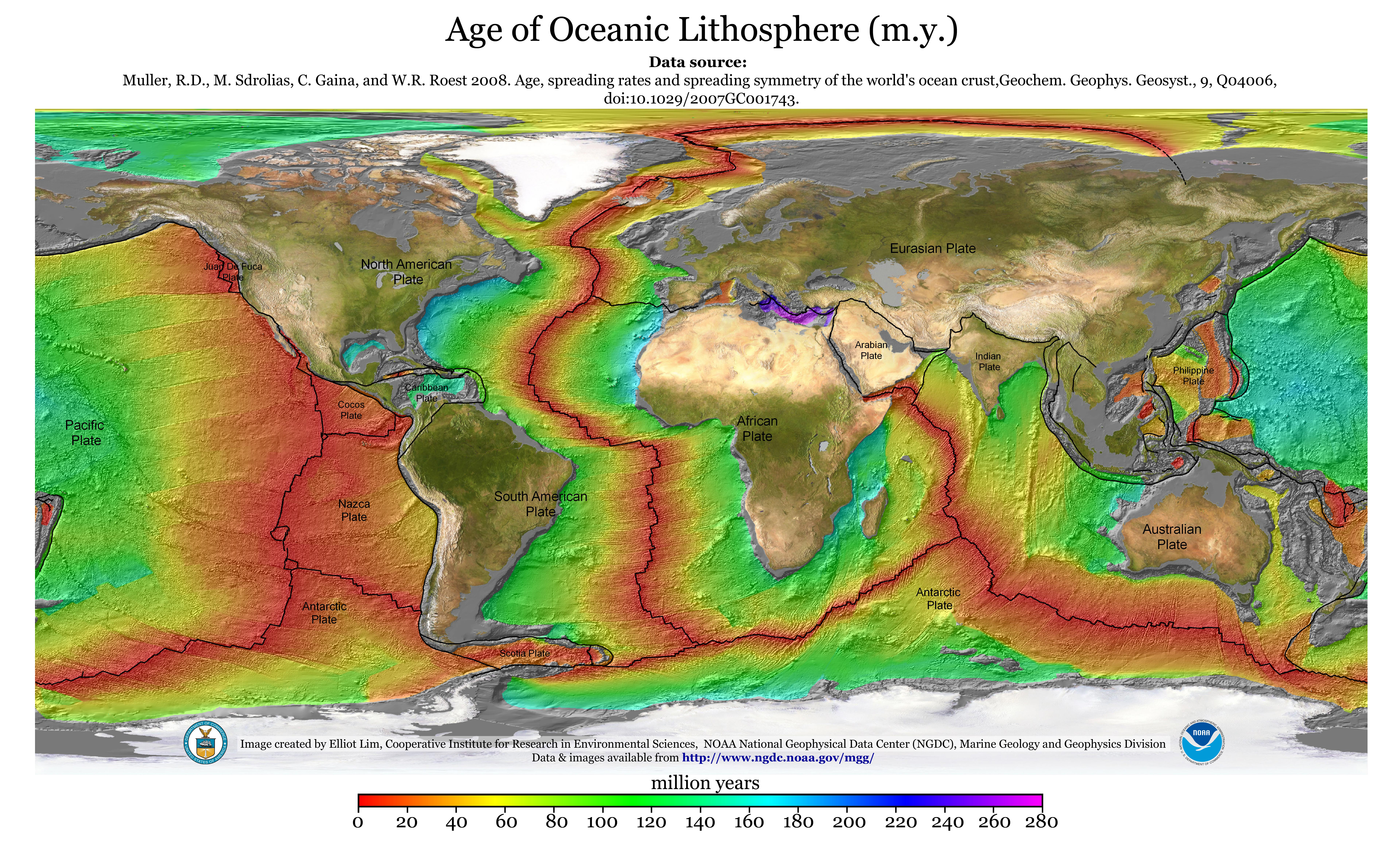
Seafloor spreading is a geologic process in which tectonic plates—large slabs of Earth's lithosphere—split apart from each other.
Seafloor spreading and other tectonic activity processes are the result of mantle convection.
Mantle convection is the slow, churning motion of Earth’s mantle.
Convection currents carry heat from the lower mantle and core to the lithosphere.
Convection currents also “recycle” lithospheric materials back to the mantle.
3D fly-thru of bathymetry from the Rodriguez Triple Junction in the Indian Ocean,
with the flight going from east to west and diving down the Southwest indian Ridge (SWIR).
Seafloor spreading and rift valleys are common features at “triple
junctions.” Triple junctions are the intersection of three divergent
plate boundaries. The triple junction is the central point where three
cracks (boundaries) split off at about 120° angles from each other.
Seafloor spreading occurs at divergent plate boundaries.
As tectonic plates slowly move away from each other, heat from the mantle’s convection currents makes the crust more plastic and less dense.
The less-dense material rises, often forming a mountain or elevated area of the seafloor.
Eventually, the crust cracks.
Hot magma fueled by mantle convection bubbles up to fill these fractures and spills onto the crust. This bubbled-up magma is cooled by frigid seawater to form igneous rock.
This rock (basalt) becomes a new part of Earth’s crust.
Mid-Ocean Ridges
Seafloor spreading occurs along mid-ocean ridges—large mountain ranges rising from the ocean floor.
The Mid-Atlantic Ridge, for instance, separates the North American plate from the Eurasian plate, and the South American plate from the African plate.
The East Pacific Rise is a mid-ocean ridge that runs through the eastern Pacific Ocean and separates the Pacific plate from the North American plate, the Cocos plate, the Nazca plate, and the Antarctic plate.
The Southeast Indian Ridge marks where the southern Indo-Australian plate forms a divergent boundary with the Antarctic plate.
Seafloor spreading is not consistent at all mid-ocean ridges.
Slowly spreading ridges are the sites of tall, narrow underwater cliffs and mountains.
Rapidly spreading ridges have a much more gentle slopes.
The Mid-Atlantic Ridge, for instance, is a slow spreading center.
It spreads 2-5 centimeters (.8-2 inches) every year and forms an ocean trench about the size of the Grand Canyon.
The East Pacific Rise, on the other hand, is a fast spreading center.
It spreads about 6-16 centimeters (3-6 inches) every year.
There is not an ocean trench at the East Pacific Rise, because the seafloor spreading is too rapid for one to develop!
The newest, thinnest crust on Earth is located near the center of mid-ocean ridge—the actual site of seafloor spreading.
The age, density, and thickness of oceanic crust increases with distance from the mid-ocean ridge.
Geomagnetic Reversals
The magnetism of mid-ocean ridges helped scientists first identify the process of seafloor spreading in the early 20th century.
Basalt, the once-molten rock that makes up most new oceanic crust, is a fairly magnetic substance, and scientists began using magnetometers to measure the magnetism of the ocean floor in the 1950s. What they discovered was that the magnetism of the ocean floor around mid-ocean ridges was divided into matching “stripes” on either side of the ridge.
The specific magnetism of basalt rock is determined by the Earth’s magnetic field when the magma is cooling.
Scientists determined that the same process formed the perfectly symmetrical stripes on both side of a mid-ocean ridge.
The continual process of seafloor spreading separated the stripes in an orderly pattern.
Geographic Features
Oceanic crust slowly moves away from mid-ocean ridges and sites of seafloor spreading.
As it moves, it becomes cooler, more dense, and more thick.
Eventually, older oceanic crust encounters a tectonic boundary with continental crust.
In some cases, oceanic crust encounters an active plate margin.
An active plate margin is an actual plate boundary, where oceanic crust and continental crust crash into each other.
Active plate margins are often the site of earthquakes and volcanoes.
Oceanic crust created by seafloor spreading in the East Pacific Rise, for instance, may become part of the Ring of Fire, the horseshoe-shaped pattern of volcanoes and earthquake zones around the Pacific ocean basin.
In other cases, oceanic crust encounters a passive plate margin.
Passive margins are not plate boundaries, but areas where a single tectonic plate transitions from oceanic lithosphere to continental lithosphere.
Passive margins are not sites of faults or subduction zones.
Thick layers of sediment overlay the transitional crust of a passive margin.
The oceanic crust of the Mid-Atlantic Ridge, for instance, will either become part of the passive margin on the North American plate (on the east coast of North America) or the Eurasian plate (on the west coast of Europe).
New geographic features can be created through seafloor spreading.
The Red Sea, for example, was created as the African plate and the Arabian plate tore away from each other. Today, only the Sinai Peninsula connects the Middle East (Asia) with North Africa. Eventually, geologists predict, seafloor spreading will completely separate the two continents—and join the Red and Mediterranean Seas.
Mid-ocean ridges and seafloor spreading can also influence sea levels.
As oceanic crust moves away from the shallow mid-ocean ridges, it cools and sinks as it becomes more dense.
This increases the volume of the ocean basin and decreases the sea level.
For instance, a mid-ocean ridge system in Panthalassa—an ancient ocean that surrounded the supercontinent Pangaea—contributed to shallower oceans and higher sea levels in the Paleozoic era. Panthalassa was an early form of the Pacific Ocean, which today experiences less seafloor spreading and has a much less extensive mid-ocean ridge system.
This helps explain why sea levels have fallen dramatically over the past 80 million years.
Seafloor spreading disproves an early part of the theory of continental drift.
Supporters of continental drift originally theorized that the continents moved (drifted) through unmoving oceans.
Seafloor spreading proves that the ocean itself is a site of tectonic activity.
Mid-ocean ridges extend for 70,000km around the globe.
They are the Earth's tectonic plate boundaries and creators of its crust.
Yet theyremain almost completely unexplored.
In this short film, Frank Pope, a marine biologist and ocean, gives a glimpse of what we do know about these fiery sea monsters.
Keeping Earth in Shape
Seafloor spreading is just one part of plate tectonics.
Subduction is another.
Subduction happens where tectonic plates crash into each other instead of spreading apart.
At subduction zones, the edge of the denser plate subducts, or slides, beneath the less-dense one.
The denser lithospheric material then melts back into the Earth's mantle.
Seafloor spreading creates new crust.
Subduction destroys old crust.
The two forces roughly balance each other, so the shape and diameter of the Earth remain constant.
Cuba is the ecological crown jewel of the Caribbean.
It harbors thousands of the region’s endemic species and about half of its coastal ecosystems.
It is rare to find comparable ecosystems or such rich biodiversity anywhere in the Caribbean, and perhaps in the Western Hemisphere.
Cuba also is inextricably linked to its neighbor countries, especially the United States.
These two nations have been adversaries for over 60 years, but their common backyard is an ocean filled with limited shared resources.
Since December 2014, when then-President Barack Obama ordered the restoration of diplomatic relations with Cuba, both governments have taken steps to improve cooperation.
They include agreements to work together to protect some of the Caribbean’s most important coral reefs and marine sanctuaries.
Now, however, the Trump administration reportedly is planning to slow or halt at least some U.S. engagement with Cuba.
I am a Cuban marine biologist and have had the opportunity to be part of U.S. academia and facilitate scientific partnerships between the two countries.
Scientists on both sides are very interested in working together, and I believe that we owe it to nature and people on both sides to keep this door open.
Cuban waters provide vital spawning and nursery grounds for snapper, grouper and other marine species that are commercially important in the United States. Cuba is also a major stopover point on migration routes for many North America birds.
When I tagged and tracked longfin mako sharks with colleagues from Florida, we found that they ranged into territorial waters around Cuba, the United States, the Bahamas and Mexico – showing clearly just how connected our waters are.
Other scientists have reported similar results for species including manatees, sea turtles and fish larvae.
Maximum likelihood tracks for two longfin makos and the locations where they were. tagged and where their pop-up tags were released:
(A) the first longfin mako, LFM1, was tagged April 28, 2012 off northwest Florida;
and (B) the second longfin mako, LFM2, was tagged February 14, 2015 off Cojimar, Cuba.
Fish. Bull. 115:104/Mote Marine Laboratory.
Since the U.S. government relaxed restrictions on American travel to Cuba in 2015, Cuba has experienced an explosion in international tourism, which is projected to continue.
Expanding tourism and related development, combined with longstanding poor management of reefs and fisheries and economic scarcity, could have major impacts on the waters that link our countries.
Although Cuba’s coastal habitats are in fairly good condition, its fish populations are heavily exploited and threatened by commercial and private subsistence fisheries.
Over 80 percent of its fishery resources are in critical condition.
In many coastal communities, for example, small private fishermen depend on fish for subsistence and also supplement their incomes by selling fish on the black market.
Pressures on targeted species such as tarpon and bonefish are believed to be substantial, but currently no data are available to quantify the extent and magnitude of impacts on fish populations or ecosystems.
Cuban agriculture does not presently rely on extensive use of synthetic fertilizers, pesticides or other agricultural chemicals.
This means that pollution and eutrophication (overfertilization, which produces large blooms of algae and “dead zones”) may not be major threats to its fisheries and marine ecosystems.
Nonetheless, isolated and significant pollution sources, such as food processing industries and oil refineries, affect many important bays and harbors around the island.
Their impacts on marine ecosystems currently are not well-understood or well-documented.
Cuba has established 108 marine protected areas that provide some level of protection to nearly 23 percent of the shallow waters around the island.
However, many of them are at risk due to funding shortages, lack of trained staff, poor enforcement and inefficient management.
In 2015 the United States and Cuba agreed to create partnerships between sanctuaries in the two countries, so that we can share data and ideas for conserving these sites.
Our common ocean is an essential resource for the United States and Cuba, and any action (or inaction) by one country will significantly impact the other.
Scientific collaboration to protect marine resources will benefit both nations.
Cooperation between scientific organizations in Cuba and the United States dates back to the 19th century, and has helped to maintain dialogue even during the most difficult phases of U.S.-Cuban relations.
Cuban and American scientists have worked together to address sensitive environmental issues such as shark conservation, conduct state-of-the-art research and train Cubans to do research and conservation.
At times, however, bureaucratic hurdles and misunderstandings on both sides have arisen, and government decisions or indecision have blocked good projects and ideas, such as importing and exporting equipment, organizing research expeditions and field courses, and collecting and exporting samples.
Cubans are facing very difficult economic times, and many are struggling to feed their families. In such circumstances they are unlikely to see environmental protection as a high priority.
Cuba is at a crucial decision point, choosing between an environmentally friendly development path like Costa Rica’s or a destructive Cancun-style model.
Joint Cuban-American scientific ventures should reach out to the public in both countries with a strong message about preserving our shared ocean resources.
They should also invest in communities to change environmental perceptions and attitudes.
We need to create effective incentives, increase exchanges of people and ideas, and improve communication about these issues.
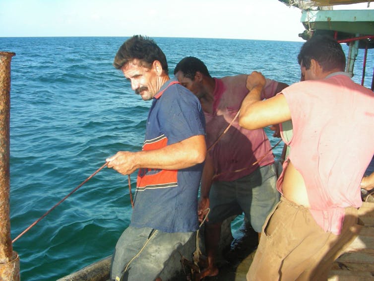
Commercial finfish fishermen, Isla de la Juventud, Cuba.
Jorge Alberto Angulo Valdes, Author provided
More academic partnerships
Academia has a key role to play in this effort. U.S. colleges and universities should explore models that offer more opportunities to Cuban scientists, and Cuban schools should do the same.
U.S. schools are already increasing their presence in Cuba through field courses that allow students to experience Cuban realities.
Other U.S. organizations such as the Environmental Defense Fund have also expanded ties with Cuban institutions and people.
Unfortunately, this process is working in only one direction.
It is much more difficult for Cubans to visit the United States, thanks to restrictions on both sides.
We need opportunities for groups of Cuban students to come to the United States for field courses and other academic programs.
Cubans and Americans have more in common than anyone may think.
Our nations are united by nature, history and cultural links that have overcome politics.
The timing is right for scientists on both sides to make a strong case in favor of normalization over confrontation, and a better future for both countries.
The Chinese Government has announced that they've completed the
construction of the world's largest floating solar farm, and it's now
producing energy.
Sungrow Power Supply have
created created a 40-megawatt solar power plant, which sits atop of a
flooded former coal-mining town in China's eastern Anhui province.
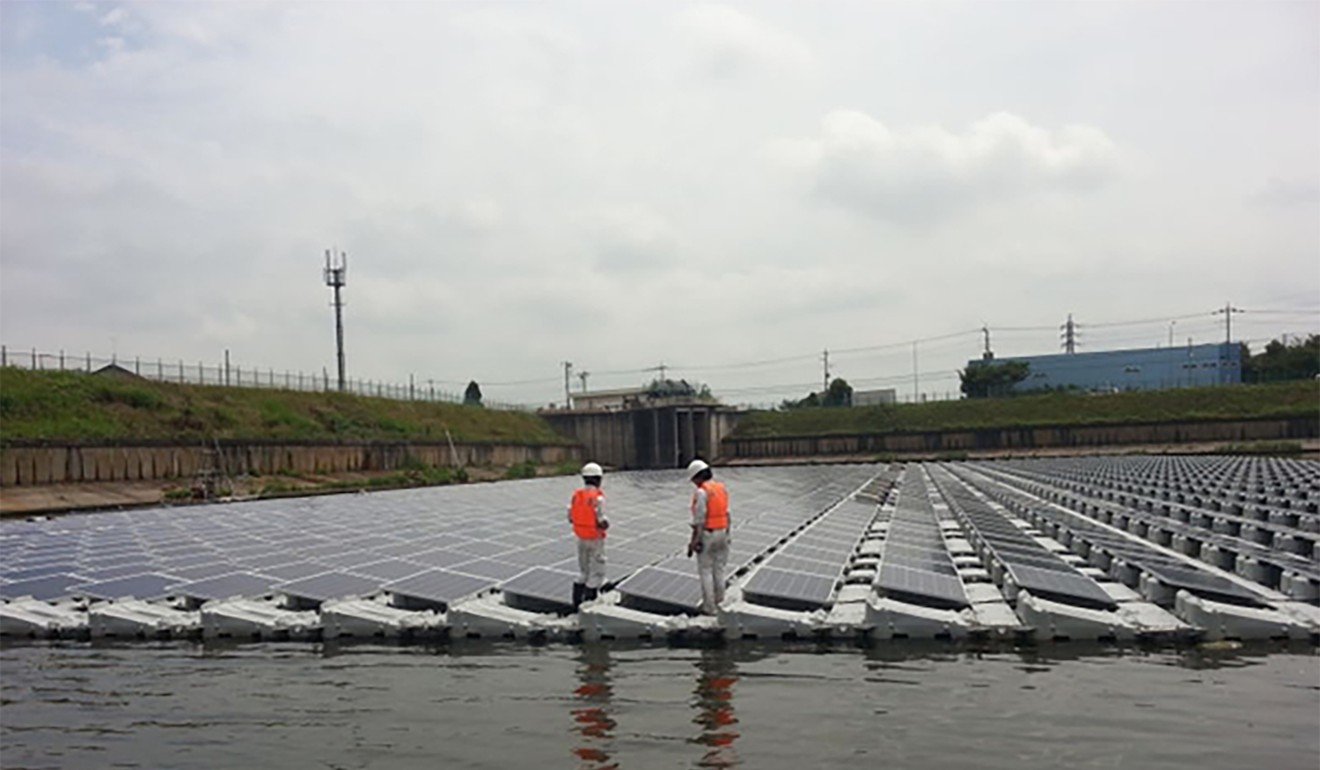
Last week, workers switched on a solar energy plant capable of producing 40 megawatts of power, which floats on a manmade lake in China’s Anhui province near the city of Huainan, reports Sarah Zheng at the South China Morning Post.
The array is the largest floating solar project in the world, though at the brisk pace China is building new renewable projects it’s unlikely to hold that title very long.
The floating solar farm occupies an area that used to be used for coal mining in Anhui province. Photo: Handout
Built by the company Sungrow Power Supply, the power plant will produce enough energy to power 15,000 homes, Zheng reports.
While the company has not revealed the exact size of the operation, it produces twice as much energy as the previous holder of the largest-floating-solar-plant title, which is located in the same area and was launched by the company Xinyi Solar in 2016.
The new floating solar plant was connected to the grid in Huainan, Anhui in May.
Photo : Handout
Anhui province is a coal-rich region, and the Sungrow plant is located on a lake that was once the site of intensive mining.
Heavy rains filled the area with water.
As Zhen reports, the depth of the lake varies from 12 feet to 30 feet.
Floating solar power plant North of Yingtaohuan (CNES imagery)
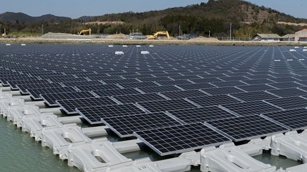
So why build solar plants on top of lakes and reservoirs? Fiona Harvey at The Guardian explains that building on bodies of water, especially manmade lakes that are not ecologically sensitive, helps protect agricultural land and terrestrial ecosystems from being developed for energy use.
The water also cools the electronics in the solar panels, helping them to work more efficiently, reports Alistair Boyle for The Telegraph.
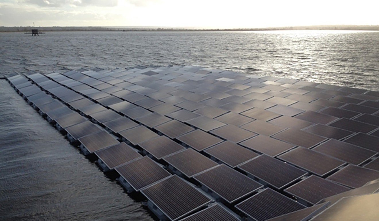
For similar reasons Britain built a 23,000-panel floating solar farm on the Queen Elizabeth II reservoir near Heathrow airport in 2016 to help power the Thames Water treatment plant.
The Sungrow solar farm is just one tiny piece in China’s push towards renewable energy.
According to Irina Slav at Business Insider, the country recently announced it would invest $361 billion in renewable power by 2020, and by 2022 could produce 320 gigawatts of wind and solar power and 340 gigawatts of hydropower.
Zheng reports that currently renewables are responsible for 11 percent of China’s energy and may reach 20 percent by 2030.
The water helps to cool the surface of the solar panels, reducing the risk of overheating.
Photo: Handout
While the floating solar plant is the largest in the world, it pales in comparison to some of China's non-floating solar projects.
The Longyangxia Dam Solar Park on the Tibetan plateau hosts 4 million solar panels that produce 850 megawatts of energy.
Even that will soon be eclipsed by a project in the Ningxia Autonomous Region, which will have 6 million solar panels and produce 2 gigawatts of power.
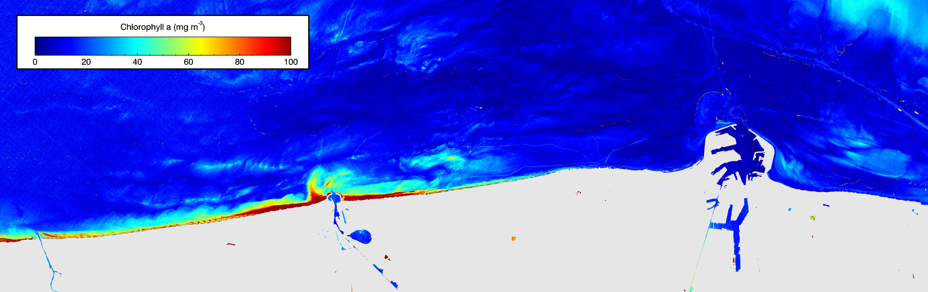
Last year, the Sentinel-2A satellite captured an intense algal bloom very close to the Belgian coast.
The high-resolution capabilities of Sentinel-2’s main instrument are allowing scientists to monitor algae blooms in areas previously not possible to observe with satellites.
Like many European countries, Belgium regularly reports on the quality of its coastal waters to the European Commission.
Water quality measurements have been made from ships for this purpose since the 1980s and, for over a decade, satellite data from Envisat and from Sentinel-3A have been used to supplement ship-based measurements.
While these satellite data have been vital for water quality monitoring, they do not provide the adequate coverage nor resolution for monitoring close to the coast.
Chlorophyll concentrationOn 1 May 2016, the Sentinel-2A satellite captured an algal bloom close to Belgium’s coast.
Thanks to the multispectral capabilities of Sentinel-2’s main instrument, chlorophyll a absorption and hence concentration can be derived, revealing an intense phytoplankton near the Port of Ostend.
The Sentinel-2 mission, however, carries a high-resolution multispectral instrument that has great advantages for monitoring near-shore waters.
With this finer resolution data now available, scientists can properly analyse the water within 2 km of the coast.
In May 2016, scientists discovered an intense algal bloom in a previously ‘unseen’ zone.
Owing to the bloom’s extent and the shallow water depth, it would have been nearly impossible to detect or sample using shipborne measurements.
“This satellite image was a surprise to me!” said Kevin Ruddick, scientist at the Royal Belgian Institute for Natural Sciences.
“I have spent a few weeks each year over the last 20 years making measurements at sea from the Belgica research vessel, but we do not get so close to the coast because the water is too shallow. The ship must have been quite close to such blooms in May 2016 but did not even realise that this was happening.”
Algae blooms are a normal phenomenon, providing food for marine organisms.
But sometimes they can be harmful to humans and animals when they produce toxic substances, or occur too often or last too long, depleting the concentration of oxygen in the water.
Water turbidity off the Belgian coast
On 1 May 2016, the Sentinel-2A satellite captured an algal bloom close to Belgium’s coast.
The multispectral capabilities of Sentinel-2’s main instrument allow for an estimate of water turbidity.
In this example from May 2016, the algal species is almost certainly phaeocystis globosa, which is not toxic and does not noticeably deplete oxygen in Belgian waters because these waters are highly turbulent and quickly draw down oxygen from the atmosphere.
Instead, it creates foam on the beaches which is a nuisance for beach-goers as well as fishermen as it makes their nets sticky and difficult to manage.
Nonetheless, it is important to monitor blooms so that fishermen, fish farmers and public health officials know about such events as soon as possible – even more so when the species may be toxic.
With its 13 spectral channels, the Copernicus Sentinel-2 mission’s novel imager can capture water quality parameters including algal blooms, as well as surface concentration of chlorophyll and turbidity (or water clarity) – giving a clear indication of the state of the near-shore environment.
This information is particularly important for meeting the monitoring requirements of the European Commission’s Water Framework and Marine Strategy Framework Directives.
The Royal Belgian Institute for Natural Sciences is funded by the European Commission's FP7 Research Programme HIGHROC Project to develop and test methods to use Sentinel-2 data for this purpose.


