Saturday, July 13, 2019

Why the 'Great Wave' has mystified art lovers for generations


From CNN by Dan Tham

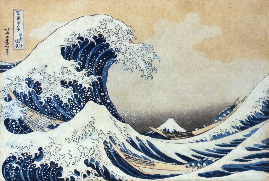
A massive wave threatens to engulf three fishing boats, its foam crown extending like claws, menacing the rowers below.
It's an epic scene of human struggle and natural terror that dwarfs the sacred Mount Fuji just behind it.

This is "The Great Wave off Kanagawa," a woodblock print by the Japanese artist Katsushika Hokusai and one of the world's most iconic pieces of Asian art.

If this climactic moment seems ubiquitous -- think T-shirts, coffee mugs, laptop decals -- that's because it was designed to be.

The artwork is considered a fine, if somewhat hackneyed, example of "ukiyo-e," a genre of mass-produced Japanese woodblock prints that displayed everything from theater announcements to the most salacious of erotica.

Ukiyo-e prints were cheap to produce and widely distributed in Edo (today's Tokyo) between the 17th and 19th centuries.
As many as 5,000 impressions were made from the original woodblocks for "The Great Wave.
" Back then, the prints were sold for the price of a bowl of noodles.

By the time "The Great Wave" made its debut, in around 1830, Japan was flirting with the idea of ending more than 200 years of isolationism.
The story of growing foreign influence is evident in Hokusai's masterpiece -- the rich shade of blue used in the prints was imported from Europe.
Prussian blue, as it's commonly known, was a synthetic color created in the 18th century and prized for its depth and durability.

That Hokusai employed the hue as the principal actor in his oceanic drama suggests that he was depicting Japan on the cusp of change.
As much as the wave portends instability and danger, it also suggests possibility and adventure.

'Essence' of Japan

Hokusai spent most of his life in the riverside district of Sumida, Tokyo, where he adopted at least 30 pseudonyms and, perhaps, just as many different styles.
"The Great Wave" was the first in his series "Thirty-six Views of Mount Fuji," a virtuosic study of Japan's highest and most revered mountain.

The term "aizuri-e" refers to woodblocks made predominantly from blue inks.

"Many people view the painting as the very essence of Japanese culture," says Atsuko Okuda, chief curator of the Sumida Hokusai Museum in Japan.
"The simple and powerful composition of the mountain and the shape of the wave strikes right at the heart of the observer."

Observers famously included French Impressionists Edgar Degas and Claude Monet, as well as Dutch master Vincent van Gogh, who was enamored with "The Great Wave."
They were not alone: In the 1860s, the proliferation of ukiyo-e in Europe led to an artistic fascination with Japan in the West, known as "Japonisme."

The bold colors and outlines found in Van Gogh's "Courtesan (after Eisen)" shows the influence of Japanese woodblock prints.
Credit: Courtesy Van Gogh Museum, Amsterdam/Vincent van Gogh Foundation

Yet, the woodblock prints weren't considered art in Japanese society during the Edo period, according to Yukiko Takahashi, the sixth-generation owner of the Takahashi Kobo publishing house.

"At some point, ukiyo-e was brought to foreign countries," says Takahashi, whose family has been making ukiyo-e for more than 150 years.
"We Japanese didn't realize how wonderful they were, because we took them for granted in our daily lives."

An endangered art

At Takahashi's workshop, craftsman Noriyasu Soda works on a replica of Hokusai's "Great Wave.
" He first dampens the "washi" paper, before applying paint and a small amount of rice glue to the woodblock to ensure that the colors stick.

Each side of any given block represents a different color that will be layered into the ukiyo-e.
This piece alone requires a black outline, various blues for the water, and shades of yellow and pink for the sky.

In the earlier stages of his career, Hokusai worked on a number of brightly colored illustrated books.

The process is painstaking and demands utmost precision.
Takahashi says it takes about a decade to become a true ukiyo-e "shokunin," or master craftsman, and that there are only 25 left in Tokyo today.

"We have to succeed in passing down this wonderful technique of ukiyo-e woodblock prints," she says.
"The craftsmen involved in this work are trying their best to teach these skills to the next generation."

The Great Plastic Wave Illustration
A reimagined version of Hokusai’s - ‘The Great Wave’ by Nic Mac, illustrative response to the issues regarding the record levels of Plastic in our oceans.

Links :

Friday, July 12, 2019

Canada (CHS) layer update in the GeoGarage platform

39 nautical raster charts updated & 3 new charts added

Is 5G a reality for Superyachts in 2019


From SuperYachtTechnology

5G is set to be ‘mainstream’ by 2019.
But what does 5G mean for superyachts?

5G has for a long time seemed like something far away in our technological future, often talked about but never given serious clout in the present.
Despite the excitement surrounding it, when predictions of 5G delivery were made there were seen as premature and unrealistic.
In a 2016 interview Richard McLaughlin, cofounder of marine WiFi solutions business Aigean Networks expressed how he had been convinced by claims of early 5G plans only for reality to fall short.
“I wasn’t sure Wi-Fi was going to be where it was at with 5G data plans coming along.
I was proven wrong.
Cellular hasn’t rolled out the big speed increases they’ve been promising.
They’re always a few years away,” he said.


Yachts spend over 80% of their time inshore

Now however, 5G is very much on its way and the possibilities it will bring seem to be endless.
At Qualcomm’s 2018 CES press conference, the company predicted that 2019 will be the year that 5G becomes mainstream for mobile (though others say 2020).
These bold claims are substantiated by the fact that the 3rd Generation Partnership Project (3GPP), an organisation which works to provide complete system specifications for cellular telecommunications network technologies, finalised its first 5G specs late last year.
Members of the 3GPP approved the suggested Non-Standalone (NSA) 5G New Radio (NR) specification, meaning commercial vendors now have the necessary guidelines from which they can start building products.
Director of technical marketing at Qualcomm Matt Branda backed this sentiment, saying: “This is really the step that enables vendors to start building equipment.”
The Standalone (SA) version, which will define the full user and control plane capability for 5G NR using the new 5G core network architecture, is due for completion in June.

3GPP have by no means been the only body committing resources and conducting in-depth research into 5G.
Various research bodies have looked into 5G and how it will affect different industries; NGMN (Next Generation Mobile Networks, which claims it has shaped the industry of wireless communication for the past 12 years) and GSMA (an organisation representing the interests of mobile operators worldwide) have both published papers on the topic.
In GSMA’s research paper, titled The 5G era: Age of boundless connectivity and intelligent automation, it recommends the new technology as “an opportunity for operators to move beyond connectivity and collaborate across sectors such as finance, transport, retail and health to deliver new, rich services.”
But what about the marine sector, barely mentioned in these papers?
How quickly will the 5G revolution benefit our superyachts?

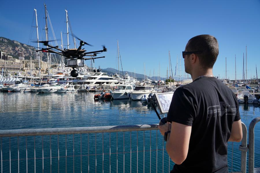
 An UAV connected in 5G, flying over the world's leading yachting market in Monaco
see gouv.mc

When Superyacht Technology News contacted the GSMA to enquire about our industry, a representative said that its 5G specialists were not aware of any specific examples of how 5G connectivity would profit the maritime sector.
This is not to say that it won’t.
NGMN’s White Paper emphasises the importance of good-quality broadband access being available everywhere, surely including the remote locations frequented by yachts.
The authors describe how with 5G, the entire world’s internet expectations will be allowed to grow.
The minimum user data rate (expected at between 50 and 100 Mbps) will be delivered consistently across coverage areas, even at cell edges where speeds would have previously dropped.
This should allow superyachts to access these higher speeds for longer.
The NGMN White Paper also states how 5G is expected to be deployed for ultra-low-cost requirements, meaning coverage areas will be expanded to include underserved and underdeveloped areas.
This will surely mean that cheaper data plans will be available for yachts in previously unattainable places.

Although there seem to have been no 5G sea trials to date, in September last year Tallink, Telia, Ericsson and Intel announced the first public, live 5G network in Europe at the Port of Tallinn, Estonia.
This trial aimed to deliver 5G connectivity to the commercial passenger cruise ships and their passengers while in port.
Each Tallink cruise ship can carry as many as 2,000 passengers, so from the perspective of area to cover and number of devices onboard, superyachts have nothing on them.
With 5G connected to the on-ship WiFi network, those onboard the vessels could use this high-speed Internet connection during mooring and departure.

This solution used Ericsson’s 5G antenna integrated radio and baseband in conjunction with the Intel® 5G Mobile Trial Platform to transfer passenger data traffic along with data from the ship’s own information and communications systems to a millimetre wave, extending Telia’s mobile network to 5G.
So, it’s clear that achieving this level of connectivity would necessitate an infrastructure upgrade on most yachts.
As Dermot Crotty, Sales Manager at e3 Systems France & Italy joked, “Most yachts’ IT structures can’t support 4G speeds, never mind 5G!”
This kind of refit would no doubt be costly and time-consuming, but the long-term benefits would be worth it.

The Port of Hamburg is the testing ground for 5G, the next generation mobile standard that is set to transform communications.
After six months of preparation the project partners - Hamburg Port Authority (HPA), Deutsche Telekom and Nokia - have now launched a testbed that stretches across some 8,000 hectares of port area. 5G is seen as the communication standard of the future.
It is an entirely new network concept that combines terrestrial and mobile networks.
The testbed in the Port of Hamburg has primarily been set up to test 5G applications in an industrial environment.
The 5G trial programme in the Port of Hamburg forms part of a two-year research project.

Earlier this month, Deutsche Telekom, Nokia and the Hamburg Port Authority also announced that they will commence 5G testing in the busy Port of Hamburg.
As a major logistics hub but also a tourist attraction, the port will test a variety of use cases that place very different demands onto a 5G network.
The Port Authority wants to use 5G to manage traffic lights within the port area, as well as collecting and processing environmental measurement data in real-time.
Virtual reality applications will also be applied to monitor critical infrastructure such as water gates and construction areas to ensure safety in the port.
However, there are no reported plans to test it on the boats moored there.

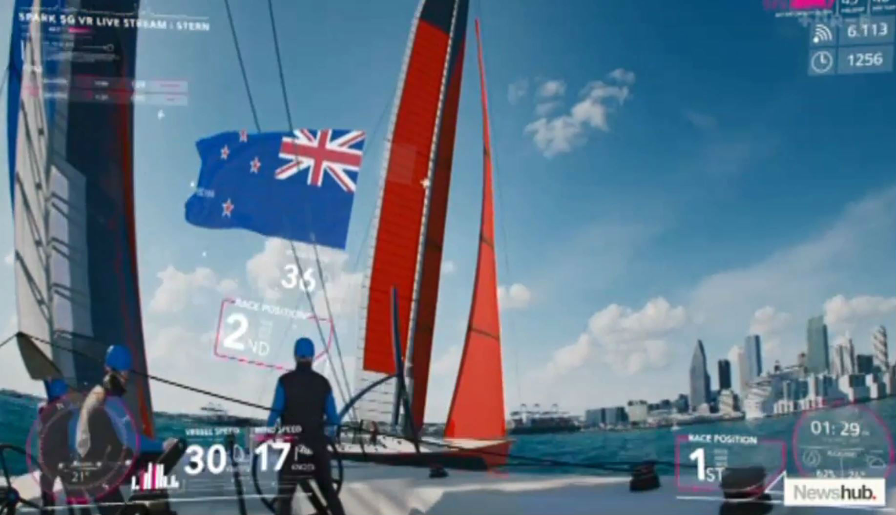
Team New Zealand to use augmented reality, 5G during America's Cup

These port trials seem like they could be the gateway to future sea trials.
From a superyacht industry perspective, we certainly hope so.
After all, the potential damage caused to the industry if 5G does not develop at a similar speed within yachting could be serious.
It is likely that the difference between communicating on land and at sea would discourage a new generation from becoming owners, dampen the fun of the guests looking to charter out these superyachts and make working on a yacht a whole lot less appealing, with our dependence on and demand for connectivity on an upward spiral that shows no sign of stopping.

Luckily the superyacht sector is typically an early adopter of new technology, and with the sheer amount of money in the industry it tends to be true that when there is a will, there is a way.
It will be a challenge, but if ferries of 2,000 passengers a piece can achieve 5G connectivity then who is to say we can’t?
The pressure is on.

Links :

Thursday, July 11, 2019

Amazon asks FCC for approval of Project Kuiper broadband satellite operation


Amazon began simply with the task of selling books over the internet.
Yet, CEO Jeff Bezos never intended to stop there and in the past 25 years to the present day the company has expanded its aspirations to cover novel concepts such as drone-based deliveries and flying warehouses.
Now, according to recent reports spotted by Geek Wire, Amazon intends to release a constellation of 3,236 satellites into low-Earth orbit to provide internet access to underserved communities around the planet.
Digital Trends reports that the filings, for what Amazon terms “Project Kuiper,” were made with the International Telecommunication Union (ITU), an agency within the United Nations that is responsible for issues including satellite orbits.
According to an Amazon spokesperson: “Project Kuiper is a long-term project that envisions serving tens of millions of people who lack basic access to broadband internet. "

From Geekwire by Alan Boyle & Taylor Soper

Amazon is asking the Federal Communications Commission for approval of its Project Kuiper satellite broadband venture, and referring to potential synergies with Amazon Web Services as a strong selling point.

GeekWire first reported news of Project Kuiper in April, when Amazon revealed plans to put more than 3,200 satellites in low Earth orbit for global broadband coverage.
That revelation was contained in documents that were filed with the International Telecommunication Union.
On Thursday, Amazon’s wholly owned Kuiper Systems subsidiary followed up with a fresh set of FCC filings.

 Satellites could extend cloud computing to the final frontier.
"The Kuiper System covers the area between 56°N and 56°S latitudes," the Amazon subsidiary told the FCC. "Accordingly, customers throughout [the] continental US, Hawaii, and all US territories will have access to Kuiper System services. So too will customers in many other countries within the coverage area. The Kuiper System will not provide FSS [fixed-satellite service] in the majority of Alaska, however, because the state's high latitude is outside of the coverage area."
Amazon is the latest in a string of companies with plans to use a network of thousands of satellites to offer broadband around the world.
Unlike traditional satellite internet, these plans involve the use of satellites in low Earth orbit, which can be operated cheaply and with lower latencies. SpaceX has plans to launch as many as 12,000 satellites as part of its Starlink constellation, OneWeb wants to launch 650 satellites, and Facebook is also developing an internet satellite of its own.
Lockheed Martin illustration

The filings confirm that the project would consist of 3,236 satellites in 98 orbital planes, at altitudes ranging between 366 and 391 miles (590 and 630 kilometers).
“Amazon’s mission is to be Earth’s most customer-centric company, and the Kuiper System is one of our ambitious projects to fulfill this mission,” the application reads.
“The Kuiper System will deliver satellite broadband communications services to tens of millions of unserved and underserved consumers and businesses in the United States and around the globe.”

In the filings, Kuiper Systems cites studies showing that 3.8 billion people around the world lack reliable broadband service, and that 21.3 million Americans don’t have access to fixed broadband.

Last month, Amazon CEO Jeff Bezos emphasized the rationale for the risky project during a fireside chat at the company’s Amazon’s inaugural re:MARS conference.
“The goal here is broadband everywhere,” Bezos said.

Kuiper Systems’ application says the satellite system would take advantage of the Seattle tech giant’s expertise in providing consumer services, as well as the ground-based infrastructure that’s been built for Amazon Web Services:
“Amazon sells products and services to hundreds of millions of customers today via physical and online stores, entertainment content streaming, design and manufacturing of consumer electronics devices, and leading public cloud computing web services.
Amazon also has global terrestrial networking and compute infrastructure required for the Kuiper System, including intercontinental fiber links, data centers, compute/edge compute capabilities and the tools, techniques, and know-how to securely and efficiently transport data.”

The application says “Amazon will leverage its resources and capabilities to develop, implement and interconnect the Kuiper System and terrestrial networks to delight customers.”
Such statements seem to suggest links between Kuiper and other lines of business ranging from online sales to cloud services and video streaming.

Other companies besides Amazon have big satellite ambitions as well: SpaceX, for example, has begun deploying satellites in low Earth orbit, or LEO, for its Starlink broadband constellation.
SpaceX CEO Elon Musk said earlier this year that the revenue from Starlink could amount to $30 billion or more annually.
OneWeb, Telesat and LeoSat Technologies also have plans for providing broadband via LEO satellites.
That’s led some experts to wonder how many mega-constellations the world needs, and how many satellites the night sky can handle.

In fact, the FCC filings acknowledge that Project Kuiper’s satellites would have to play nice with other companies’ satellites when it comes to sharing broadcast spectrum and avoiding interference.
Kuiper intends to use Ka-band radio frequencies, including a part of the spectrum that Iridium is already using for its next-generation telecom satellite constellation.

Kuiper Systems’ filings note that the FCC has laid out procedures for different companies to share spectrum, and so the venture is seeking waivers from the agency to proceed with systems and procedures that would address interference concerns.
It’s also seeking a waiver from an FCC requirement to serve all of the United States and its territories, on the grounds that parts of Alaska are too far north to get satellite reception from Kuiper’s constellation.

In its technical analysis, Kuiper Systems says it can start offering satellite broadband service once it finishes the first of five phases of deployment by putting 578 satellites in their proper orbits.
Like SpaceX’s Starlink satellites, Kuiper’s satellites would be launched into lower orbits at first, and then have those orbits raised once they’re checked out.

The filings don’t go into detail about Project Kuiper’s satellite design, but they do say the spacecraft would use phased-array antennas to produce “steerable and shapeable” beams.
The satellites would use an “unpressurized, non-explosive propellant” for safety’s sake.
And to address concerns about orbital debris, the satellites would be designed to deorbit themselves in less than 10 years, even if they fall out of contact with ground controllers.

There’s no mention of when Kuiper’s satellites would be launched, or which company would launch them.
Bezos’ privately held space venture, Blue Origin, could conceivably take on the job — but that could get tricky, because publicly traded Amazon would have to guard against conflicts of interest.

The filings confirm that Rajeev Badyal, the satellite engineer who once led SpaceX’s Starlink effort but was reportedly fired last year, is the president and manager of Kuiper Systems.
And although most of the jobs listed for Project Kuiper are in Bellevue, Wash., the headquarters for Kuiper Systems is listed as 410 Terry Ave. N. in Seattle’s South Lake Union district — which is Amazon’s headquarters building.

Links :

Wednesday, July 10, 2019

The multinational story behind the Grace1

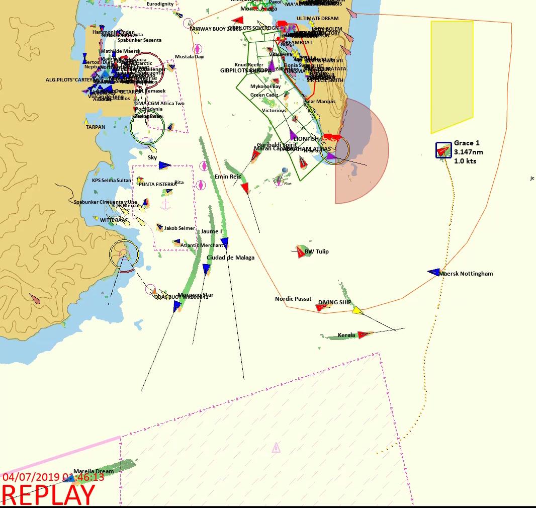
A British Royal Navy patrol vessel guards the oil supertanker Grace 1, that’s on suspicion of carrying Iranian crude oil to Syria, as it sits anchored in waters of the British overseas territory of Gibraltar, historically claimed by Spain, July 4, 2019.

From Windward by Omer Primor

Panamanian flag, Singaporean manager, Iranian oil: six words and three countries that tell the multinational story of the Grace 1, the oil tanker detained in Gibraltar by the UK earlier this week for violating EU sanctions.
Less than 24 hours later, Tehran admitted being the real owner of the vessel carrying some two million barrels of sanctioned, Iranian oil, disguised as being of Iraqi origin.


The supertanker Grace 1 off the coast of Gibraltar, on July 6, 2019.
AFP

But the case of the Grace 1 is about more than just Iran.
It goes to the heart of the challenges of enforcing sanctions today.
The rules of the game have changed, and those attempting to evade sanctions are increasingly doing so using “innocent” ships.
Gone are the days of sanctioned trade being carried by the National Iranian Tanker Company (NITC), or by vessels flying the North Korean flag.
In the past 60 days, Iranian-flagged tankers made less than a handful of port calls outside their home country.
North Korean tankers had none.

Ties to Iran

So what exactly were the Grace 1’s ties to Iran? Investigating its ownership would lead nowhere.
According to Equasis, it is owned and managed by Singaporean companies, its real, beneficial owner remains unknown, passing screening against databases of sanctioned entities (such as SDN lists) and rules relating to the country of registration.

Grace 1 Ownership Details. Source: Equasis

Ownership databases also show a connection between the Grace 1’s registered owner and manager: both are listed under the same address in Singapore.
In fact, the two share contact information with three other companies, each listed as a registered owner of a ship managed by the same manager.

Going beyond ownership to investigate the vessel’s port calls and historical locations would also lead to a dead end.
The Grace 1 was last detected in port almost two years ago, in Qingdao, China.
Since then, it’s been operating continuously at sea; any port calls it may have made have been masked by turning off its mandatory AIS transmissions.


The Grace 1’s recent history of port calls: Source: Windward


Grace 1 of Many

What’s perhaps even more troubling is that the Grace 1 isn’t alone.
In May, 19 crude oil tankers (3% of all crude tankers operating in the Gulf) went dark while operating in the area, behavior indicative of sanctions evasion.
While eight of those were Iranian flagged and obviously a no-go for trade, the other 11 aren’t as easy to screen: seven were Panamanian, two Liberian and two Vietnamese.
None of them is registered by an Iranian Company or made port calls in Iran, making them almost impossible to detect using existing vessel tracking and list-based screening.

Image showing 18 dark activities by the 11 tankers in May.
Source: Windward

What’s more, these 11 tankers went on to make 68 ship-to-ship meetings offshore Fujairah, in the UAE, in May-June.
There, they received logistical support and transhipped cargoes to other tankers.
In one incident, a crude carrier picked up cargo from the Grace 1 offshore Fujairah and carried it to Singapore, very possibly without knowing cargo’s origin.

Image showing 68 ship-to-ship meeting offshore Fujairah in May -June by the 11 tankers.
Source: Windward

As with the recent case of the Pacific Bravo, the use of front companies, transshipments, dark operations, and identity changes creates new risks for the entire maritime supply chain – ports and terminals, traders, bunkering services providers, financial institutions, and even governments – which are now required by OFAC to go beyond existing vessel tracking and list-based screening.

Shipping has always been a complex industry.
Tax structures and other considerations dictate the use of Special Purpose Vehicles (SPVs) for ownership of every vessel.
It’s clear the vast majority of players aren’t interested in trading in sanctioned cargoes.
However, at a time when the business climate is becoming increasingly complex, and with so much attention on every ship movement and every cargo, many companies are left wondering how should they implement these new regulations – especially when existing compliance controls are losing their effectiveness at a rate of knots.


Refinitiv Oil Research has been tracking the Iranian VLCC Grace1
. She departed Iran on 17/04 and remained floating off UAE for 23 days before departing on 13/05. With no access to SUMED she had to pass around the Cape

source : Refinitiv

Grace 1 tanker movement between Iraq, Iran and the UAE
source : CTRM center

Business as Usual

So what can the maritime ecosystem do in order to keep business running as usual? The strongest signals indicating vessels may be violating sanctions come from behavioral analysis.
For the Grace 1, the signs have been there for at least six months – almost coinciding with the November reimposition of sanctions by the U.S.
For example, from mid-December 2018 to mid-January 2019 the ship anchored offshore Asaluyeh, Iran.
In April, it went dark for 10 days near Bushehr, also in Iran.

Image showing the Grace I anchored offshore Asaluyeh, Iran, 
for a month, Jan. 2019.
Source: Windward

Behavioral analytics is key to effectively screening against vessels potentially engaged in sanctions evasion.
Even the best tools that screen against lists, port calls and ownership data fall short when they come up against today’s elaborate schemes employed by those interested in evading sanctions.

Links :

Tuesday, July 9, 2019

US (NOAA) layer update in the GeoGarage platform

11 nautical raster charts updated

The weather machine reveals how the forecast is made—and why it's now threatened

 A journey inside the forecast :
In his new book, The Weather Machine, Andrew Blum explores the people, the technology, and the infrastructure behind the weather forecast we rely on day to day, and the role of meteorology in the study of our planet and global policy and decision making

From Gizmodo by Brian Khan

The weather forecast is one of the most ubiquitous things in our daily lives.
People talk about it when there’s nothing else to say, farmers from the Midwest to Mali use it to decide when to plant crops, and everyone loves to (wrongly) complain when it screws up.

But as smartphones have put the forecast right at our fingertips, the tools used to make it are largely out of sight and out of mind.
The Weather Machine, a new book by journalist Andrew Blum, takes a dive into the forecasts of today and how they’ve advanced from a dream espoused nearly 180 years ago.
It also examines how, after an era of unprecedented global cooperation to improve weather forecasts and access to them, the whole weather enterprise is starting to splinter, with private companies jumping in to provide forecasts at a price at the very moment our weather is becoming more chaotic thanks to climate change.

John Zillman, the former head of Australia’s Bureau of Meteorology, tells Blum in his book that the international meteorology enterprise is “one of the world’s most widely used and highly valued public goods.” And frankly, it’s hard to disagree.
As the weather forecast has become more accurate farther into the future, it has translated to valuable warnings that have saved countless lives and property.

 image : Casey Chin, Wired

The forecasts of today are grounded in decades of research, observations, and massive leaps in technology along the way, from the telegraph of yesteryear to satellites and supercomputers of today.
Blum walks through the work that took place in the mid-1800s and onwards to forecast the weather by first understanding just what the hell is happening in the atmosphere.
In doing so, he chronicles the contribution of early 20th century luminaries in field like Vilhelm Bjerknes and the Bergen School of meteorology, basically the weather equivalent of the da Vinci’s workshop, and Lewis Fry Richardson, who imagined creating a forecast using 64,000 human computers.

These early weather pioneers and the people who assisted them derived equations, launched balloons, and set up rudimentary networks of stations on the ground in an effort to untangle the largely mysterious workings of the atmosphere and how it affects the weather.
They also relied on the burgeoning network of telegraphs to share observations from around the world rapidly, helping assemble some of the earliest weather models to make basic, local forecasts.
Blum also delves into how the weather observing system and forecast slowly became drawn into the orbit—like so many things—of the military-industrial complex during World War II.
That trajectory continued into the Cold War, with John F.
Kennedy using it as a crucial piece of diplomacy with the Soviet Union when he proposed “further cooperative efforts between all nations in weather predictions and eventually weather control.” (We’re still working on the second part of that.)

‘This fascinating book reveals the existence and origins of surely one of our species’ greatest creations’ (Mark Vanhoenacker, author of Skyfaring)
The Weather Machine is about a miraculous-but-overlooked invention that helps us through our daily lives – and sometimes saves them – by allowing us to see into the future.
Shall we take an umbrella… or evacuate the city?
When Superstorm Sandy hit North America, weather scientists had predicted its arrival a full eight days beforehand, saving countless lives and astonishing us with their capability.
Their skill is unprecedented in human history and draws on nearly every major invention of the last two centuries: Newtonian physics, telecommunications, spaceflight and super-computing.
In this gripping investigation, Andrew Blum takes us on a global journey to explain this awe-inspiring feat – from satellites circling the Earth, to weather stations far out in the ocean, through some of the most ingenious minds and advanced algorithms at work today.
Our destination: the simulated models they have constructed of our planet, which spin faster than time, turning chaos into prediction, offering glimpses of our future with eery precision.
This collaborative invention spans the Earth and relies on continuous co-operation between all nations – a triumph of human ingenuity and diplomacy we too often shrug off as a tool for choosing the right footwear each morning.
But in this new era of extreme weather, we may come to rely on its maintenance and survival for our own. photo : AP

The history is totally fascinating to anyone with even a passing interest in weather or technology, and it lays the groundwork for really appreciating just how good we have it today.
The book’s final chapters take the reader on a jaunt from a weather satellite launch to the European Centre for Medium-Range Weather Forecasts, home of the vaunted Euro model that became famous for nailing Superstorm Sandy’s forecasts well before its competition.
In doing so, Blum lays bare how the weather enterprise has improved through huge jumps in technology but also continued cooperation around the world, because the weather knows no borders.

But the advent of for-profit companies with access to massive computing power, and in the case of Google, Apple, and Microsoft, the tiny weather stations in smartphones, now threatens to cleave the world into weather haves and have nots.
The Euro model, for example, is available to basically anyone with an internet connection (seriously, you can go check it right here).
But private companies are coming up with pay-for forecasts using it and other tools with more regularity, creating a weather arms race become companies dealing with everything from oil, gas, and crop futures to how much wind will blow and turn wind farms on a given day.

As Blum writes, “[w]hen the Weather Company [which is owned by IBM] sells its global forecasts to Facebook, and Facebook is a nation’s main source of news, where does that leave the nation’s weather service?”
The privatization of weather isn’t necessarily all bad, since you can now check the weather at a moment’s notice on your iPhone app (which is powered by the Weather Channel, formerly owned by the Weather Company).
But it does risk diluting the authority of national weather services and the warnings they issue for dangerous weather.
What if, for example, Google decided to start issuing its own storm surge forecast for hurricanes?
If you lived outside Google’s area of inundation but within the one being forecast by the national weather service, which would you trust?
What if you decided to stay based on Google’s forecast and were seriously injured when the forecast busted?
Who is to blame, and what recourse is there?

Links :

Monday, July 8, 2019

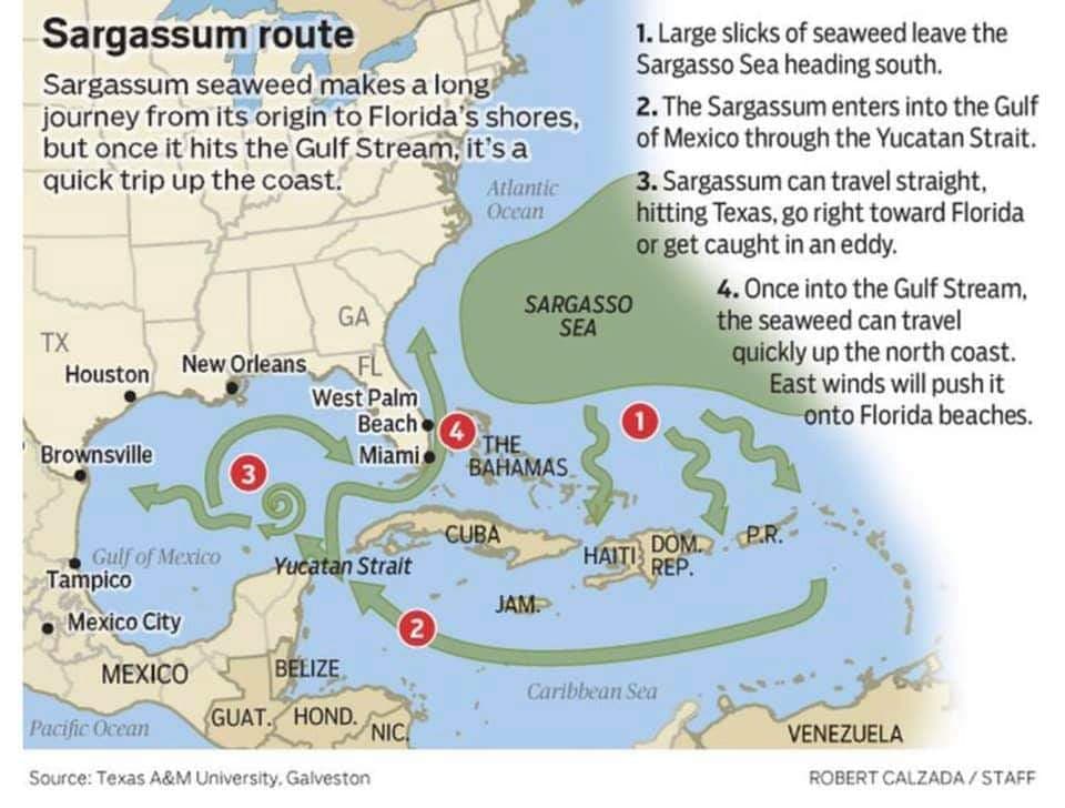
Why waves of seaweed have been smothering Caribbean beaches

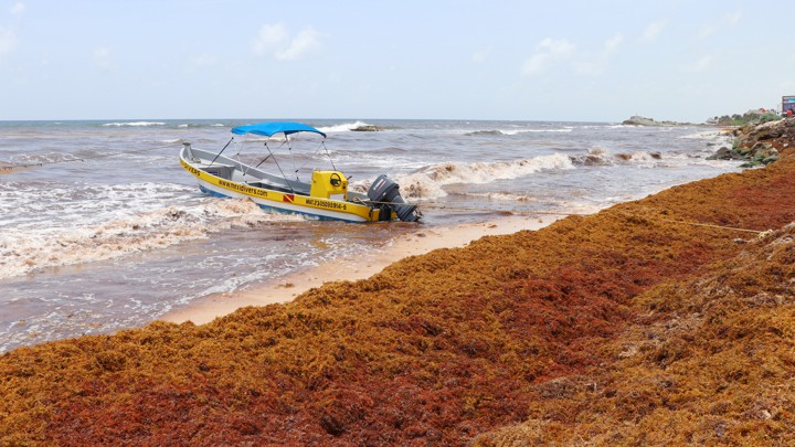
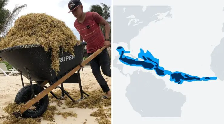
Sargassum algae piles up along Mexico's Punta Piedra beach.
Reuters
 
From The Atlantic by Ed Yong

Since 2011, blooms of Sargassum have wreaked havoc on tropical shores.
A new study explains why this is likely a new normal.

In 2018, as seaweed piled up on beaches throughout the Caribbean, it began to rot.
Already stinking and sulfurous, the thick layers began to attract insects and repel tourists.
The seaweed—a type of brown algae called sargassum—had grown in the ocean and washed ashore in unprecedented quantities.
It prevented fishers from getting into the water, and entangled their nets and propellers.
It entangled sea turtles and dolphins, too, fatally preventing them from surfacing for air.
It died and sank offshore, smothering seagrass meadows and coral reefs.
Barbados declared a national emergency.

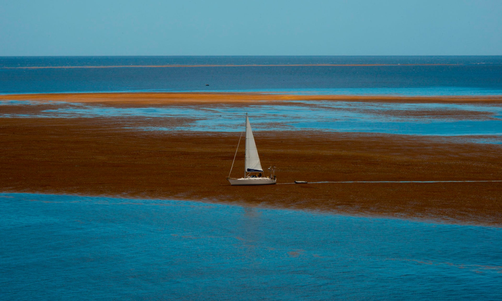
  Sargassum seaweed off the coast of Guadeloupe.
Photograph: Helene Valenzuela/AFP

In normal years, sargassum is a blessing rather than a curse.
Mats of it drift around the ocean, held afloat by gas-filled bladders that look like grapes.
They accumulate in the North Atlantic, forming the Sargasso Sea—a region that the explorer Sylvia Earle has described as a “golden floating rainforest.” The fronds are a breeding site for American eels, a sanctuary for turtle hatchlings, and a haven for hundreds of other species, some of which live nowhere else.
The Sargassum fish, for example, is a small, frog-faced predator whose body has adapted to perfectly mimic the seaweed.

The Caribbean would usually experience a few small mats of sargassum washing ashore in a given year, until 2011, when the seaweed first began arriving in unexpectedly large waves.
Similar pileups have occurred almost every year since; 2015 and 2018 saw especially bad blooms.
Some countries have set up nets to block the incoming algae, or hired people to clear affected beaches with rakes and backhoes.
And still the sargassum comes.

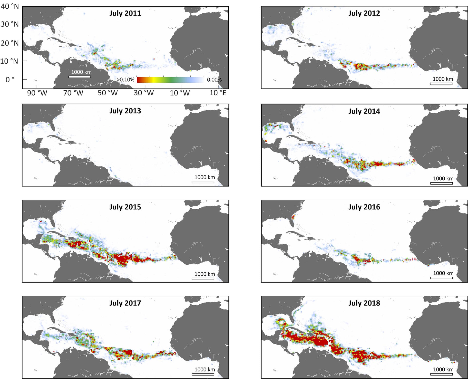
  Nasa’s satellite data confirms that the record-breaking seaweed belt forms in the summer months, with 2015 and 2018 having the biggest blooms.
Photograph: USF College of Marine Science

The seaweed does have one very convenient trait: The chlorophyll pigment within it reflects infrared light more strongly than the surrounding seawater does.
To satellites that detect infrared, sargassum blazes like a bonfire.
Six years ago, Jim Gower from Fisheries and Oceans Canada used satellite images to show that the 2011 bloom had an unusual origin.
In April, sargassum had begun growing off the coast of Brazil and near the mouth of the Amazon River, in an area far south of its normal range.
By July, it had spread across the entire Atlantic.

Now Mengqiu Wang, from the University of South Florida, and her colleagues have shown that this ocean-spanning bloom, which they’ve dubbed the Great Atlantic Sargassum Belt, is now an annual feature.
By analyzing 19 years of satellite images, they showed that the belt first appeared in 2011, and has reappeared almost every summer since (except for 2013).
Last June, when the belt was at its thickest, it contained more than 22 million tons of seaweed, and stretched fully across the Atlantic’s waters, from the Gulf of Mexico to the western coast of Africa.

That figure is likely to be an underestimate: With a spatial resolution of one kilometer, the satellite data doesn’t capture small chunks of Sargassum.
“It highlights the most aggregated areas rather than describing the entirety of what is present,” says Deb Goodwin, an oceanographer at the Sea Education Association.

The Great Atlantic Sargassum Belt is a loose collection of seaweed scattered over a very large area, not a continuous bridge.
It’s also not produced by the Sargasso Sea, which lies further north; Wang’s team confirmed that by simulating how particles of seaweed would move in the Atlantic’s currents.
They concluded that the belt likely develops from local patches of sargassum that occur naturally in the tropics.
But such patches have always existed.
Why have they only recently started to form sprawling blooms?

Wang’s team thinks that the new growth was connected to two factors on opposite sides of the Atlantic: the water discharged by the Amazon and upwelling currents rising off West Africa.
These two phenomena pump nutrients into the tropical Atlantic.
When they’re unusually strong, as they apparently were in 2009, they effectively flood the ocean with fertilizer, allowing sargassum to run amok.

But why, then, did the seaweed not bloom in 2010? Wang’s team thinks that it was delayed by low salinity (due to the influx of Amazon freshwater) and abnormally high temperatures—conditions that suppress the growth of sargassum.
Only in 2011, when temperatures returned to normal, could the seaweed make use of the influx of nutrients from previous years, and go wild.

And the bigger the blooms in the summer, the more likely they are to leave behind patches that survive through the winter.
If the conditions are right the following year, these “seed populations” can restart another bloom.
“Each successive bloom makes it difficult to imagine an end to this self-reinforcing cycle,” says Amy Siuda, an ecologist and oceanographer at Eckerd College.
“This is likely the new normal.”


So, a quartet of factors—strong Amazon discharge, strong West African upwelling, moderate temperatures, and the presence of a seed population—could potentially explain the Sargassum Belt, including why it appears every summer, and why it was especially thick in 2015 and 2018.
But such factors “have impacted the central Atlantic Ocean for decades, if not centuries,” says Siuda “Why are we only seeing sargassum bloom in this region now? What tipped the balance? There is clearly still more to learn.”

Chuanmin Hu, who led the study, agrees.
“I have to emphasize that we have no direct evidence to prove any of this,” he says.
“These are our speculations, some educated and some hand-waving.”
They’ve been forced into that because many of the factors they identified aren’t regularly measured.
For example, they could only find data on the nutrients in the Amazon for two years: 2010 and 2018.
The latter levels were much higher, which might explain why sargassum blooms were so big that year.
Or it might not.
The river might have more nutrients due to increased fertilizer use, and stronger runoffs due to deforestation.
Or it might not.
“I don’t think there’s enough data,” Hu says.
“It takes a huge amount of money to go there and take measurements.”

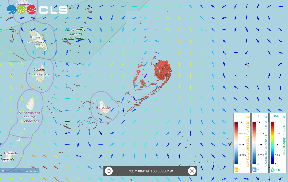
A spectacular sargassum mat in an ocean eddy.
The new detection service by CLS_Group with ESA_EO Sentinel-3 satellite data and CMEMS_EU oceancurrents has tracked this mat since May 8 and can forecast its landing.


Of the four factors that the team identified, only sea surface temperatures are regularly measured.
And while many scientists have suggested that hot water could speed the growth of sargassum, “we found the opposite,” Hu says.
That’s not to say climate change is irrelevant, he cautions: Changing patterns of rain and wind could, for example, influence the strength of the West African upwelling.
Nor should the Caribbean count on rising temperatures to solve its sargassum woes, because the pace of change is likely too slow to make a difference in the near future.

Hu adds that other factors could be behind the rise of the Sargassum Belt, including nutrient-rich dust blowing in from the Sahara and changes in ocean currents.
And several aspects of the blooms still don’t make sense.
“If I were you, I would ask: If you have so much nitrogen and phosphorus, why do other [algae] in the ocean not grow as fast?” he says.
“I can’t answer that.”

Goodwin adds that “scientific understanding of Sargassum growth and bloom dynamics under natural, open ocean conditions is extremely limited,” since scientists have only addressed these questions in lab experiments.
And the sargassum itself is changing, too.
Siuda says that the recent blooms have included “a previously rare and genetically distinct form of sargassum” that comes from the south, differs from those in the Sargasso Sea, and harbors a slightly different community of organisms.

Sargassum Seaweed Bermuda June 2019

Little is known about this strain, or how the bloom is affecting the ecology around it, which makes it hard to predict how it will react to future conditions.
And since it likely evolved in relative isolation from its northerly relatives, its northward expansion suggests that “environmental conditions and ocean circulation patterns in the central Atlantic may have been shifting, undetected, for longer than the time interval examined by [Wang and her colleagues],” says Goodwin.
“A critical larger question emerges: What drove such an ecological transformation at unprecedented scale?”

In the absence of such knowledge, it is very hard to predict when and where future blooms will occur.
“Like hurricanes or nor’easters, we will likely be able to predict the severity of the upcoming season, but we won’t be able to predict exactly where the inundations will come ashore,” Siuda adds.

As Molwyn Joseph, Antigua’s environment minister, said last summer, “We have made the assumption that this is going to be an annual thing, and the same way we prepare for hurricanes we have to prepare for Sargassum.”

Links :
Sunday, July 7, 2019

Solar eclipse 2019: Moon's shadow and hurricane seen from Space

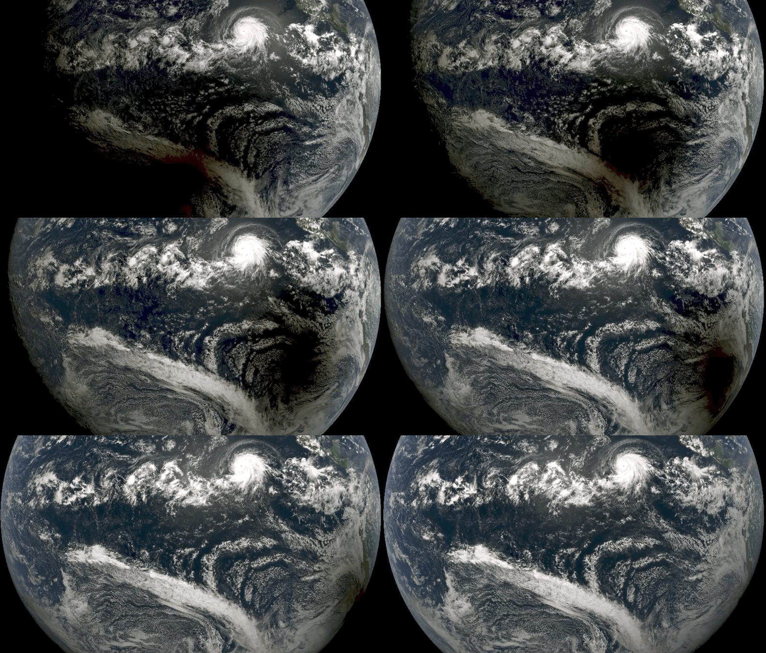
The moon's shadow passes south of Hurricane Barbara during the total solar eclipse of July 2, 2019, in this photo captured by the NOAA/NASA GOES West satellite.
(Image: © CIRA/NOAA.)
see video
 
From Space by Mike Wall

Here's something you don't see every day.
A gorgeous satellite photo shows the moon's dark, ragged shadow barreling across the Pacific Ocean, just south of Hurricane Barbara's churning clouds, during today's total solar eclipse.


That shadow reached the Chilean coast around 4:40 p.m. EDT (2040 GMT) today (July 2) and kept right on going, heading east across South America's narrow southern wedge toward the Atlantic.
Today's event was the first total solar eclipse since the August 2017 "Great American Solar Eclipse," which crossed the U.S. from coast to coast.
The next such skywatching spectacle won't occur until December 2020, when southern South America again will play host.
(Total solar eclipses occur about once every 18 months.)
The United States won't be treated to another total solar eclipse until April 2024.
But that will be a good one, with the diagonal path of totality extending northeast from Mexico all the way up through Canada's maritime provinces.
The spectacular photo was captured by GOES-West, a weather satellite that's a joint project of the National Oceanic and Atmospheric Administration (NOAA) and NASA.

Links :