Saturday, May 4, 2019

Data visualization for human transportation

Red lines are flights, blue line are ship tracks and green lines are roads


This video and interactive map of global ship movements based on AIS data is worth a minute of your time

Computing the maximum of each pixel across a time series of Sentinel-1 images enables to visualize sea lanes.
When a ship is illuminated by Sentinel1’s radar, it returns a strong signal & a bright spot is captured, while sea surface absorbs most of the signal & looks darker

Vessel density EMODnet map allows users to visualize vessel movement patterns & distribution of maritime traffic in EU waters by ship type. 

Links :

Friday, May 3, 2019

Is this the world's most dangerous sea route?


  Tierra del Fuego with the GeoGarage platform (SHN Argentina chart)

From BBC by James Clark

To commemorate the 500th anniversary of the discovery of the Strait of Magellan, a writer sets off in his grandfather’s wake to the deadly Cape Horn headland.

When I was a child, my grandfather Alfred Downes often spoke about the 128-day journey that he took in 1949 aboard the Pamir.
The famous four-masted barque, a German Flying P-Liner ship, was sailing from Port Elizabeth in Adelaide, Australia, to the town of Falmouth in Cornwall, England, filled with 60,000 sacks of Australian grain.
It was the barque’s final journey through the stormy seas of the Drake Passage, and it would be the last time a commercial sailing ship ever rounded Cape Horn in southern Chile.


To commemorate the 70th anniversary of my grandfather’s voyage and the upcoming 500th anniversary of the discovery of the Strait of Magellan sea route that separates South America’s southernmost tip with Chile’s Tierra del Fuego archipelago, I boarded the Ventus Australis expedition cruise liner in Punta Arenas, Chile.
I had always wanted to see some of the landscapes my grandfather spoke about, and while it was impossible to replicate his four-month odyssey, my four-night jaunt let me follow in the spirit of his adventure, taking me through the Strait’s narrow fjords that he sailed around and then south to the climax of his voyage: the perilous Cape Horn headland that stayed with him for the rest of his life.

Author James Clark travelled through the Strait of Magellan nearly 500 years after the sea route’s discovery (Credit: James Clark)

My grandfather left Australia as a 20-year-old deckhand on the Pamir and never returned home.
He had long dreamed of leaving Australia, as his relationship with his father was not a happy one.
His father wanted him to marry a girl from his hometown in the Adelaide suburbs and work on the family farm.
Instead, he wanted to start a new life in England.
It was a country that he knew little about, but he had always been fascinated by its history as a schoolboy.

When an opportunity to join the Pamir arose courtesy of a family friend, my grandfather quickly accepted and boarded the ship three days later alongside 33 other crewmembers.
He worked 18-hour shifts and spent his days cleaning and mopping the deck, helping in the kitchen and emptying toilets.
He hated the work so much that while other crewmembers were signing up for the 128-day return voyage back to Australia, he disembarked and headed straight to the town of Wymondham in Norfolk.
He’d heard rumours there were opportunities for farmers in the market town’s rolling countryside, and he lived there for 54 years until he died in 2003.

The only things my grandfather loved about the journey were seeing the remote Tierra del Fuego archipelago that shelters the Strait of Magellan from the ocean, breathing the Antarctic air deep into his lungs and feeling the icy-cold breeze blowing in his face.
“It was like nowhere else on Earth and a far cry from my life working on my father’s dry and arid farm,” he told me when I was a 10-year-old boy, with a look of wonder in his eyes.
“Not one single thing reminded me of home.
I felt lost and frightened, yet free.”

In 1949, the author's grandfather embarked on a 26,000km voyage aboard the Pamir from Australia to England

Seventy years later, I arrived in Punta Arenas and wandered through the city’s main square, Plaza de Armas.
A bronze statue of Ferdinand Magellan, the first European to navigate the eponymous strait in 1520 during his global, circumnavigational voyage, towers over a cannon.
The Portuguese explorer sailed near the present-day city – located near the southernmost stretch of Chile’s Patagonia region – and, as evidenced by the discolouration of his bronze boots, it is now considered good luck for those boarding cruises to touch Magellan’s toes before following in his footsteps and journeying through his strait.

For nearly 400 years, the Strait of Magellan was the main route for ships travelling between the Atlantic and Pacific oceans.
Despite its narrow 600km-long passage through a clustered network of islands and fjords, it was thought to be a quicker and safer route than rounding Cape Horn to the south and entering the infamously turbulent Drake Passage that separates Cape Horn and Antarctica’s South Shetland Islands.

The completion of the Panama Canal in 1914 caused sea traffic through the Strait to decline significantly, but unlike steamships, sailing ships coming from Australia had difficulty accessing the Canal’s western entrance because of its location in the middle of a notorious belt of doldrums.
But because of the Pamir’s 114m length and 14m beam, the mammoth, steel-hulled barque was too large to sail through the winding Strait.
Thus, my grandfather had no choice but to skirt the edges of the strait and Tierra del Fuego islands and round Cape Horn.
He was quite proud that he and his crewmates were the last commercial sailors to ever do so, saying, “Last is good, as first you go down in history.”

Author James Clark standing at the foot of the memorial to the many sailors who have lost their lives attempting to 'round the Cape' (Credit: Ben Sayer)

I sipped on a pisco sour as the crew of the Ventus Australis pulled up anchor in Punta Arenas.
The difference between my grandfather’s experience and mine wasn’t lost on me: if navigating 26,000km through some of the world’s stormiest seas was like climbing Mount Everest for a sailor, my cruise was kind of like climbing on a Sherpa’s shoulders to carry me to the top.

The lights of Punta Arenas faded as we entered the maze-like channels of the Strait.
The sky soon turned black and all I could sense was the ship’s movement over the waves.
My grandfather had spoken about long nights of darkness and loneliness on the open seas.
It had been difficult for him to leave his mother and sisters behind, but he never questioned his decision to start a new life in a new land on his own terms.

Early the next morning, I boarded a small, inflatable Zodiac and motored to the rocky shores of Ainsworth Bay.
The long fjord is surrounded by a sub-polar forest and set beneath the towering white peaks of Marinelli Glacier.
As we headed closer to the icecaps, I was stunned by the beauty of the place.
The sun reflected off of the glacier and the sea was so clear that it could have been mistaken for fresh drinking water.

I spent two hours hiking the crest of a glacial lake, passing turquoise streams and waterfalls.
The sheer silence of the place was magical.
My grandfather often recalled the silence of the region – a phenomenon he described as ‘The Patagonia Moment’.
As a child, this notion had been difficult for me to grasp, but as an adult, I loved it.
Whenever I would talk over him and my grandfather wanted me to be quiet, he would look at me sternly and say, “It’s about time you experienced The Patagonia Moment.
Just be quiet.” Ainsworth Bay was the first time in my life that I had ever experienced complete silence, and I couldn’t help but think of him.

Set in the Strait of Magellan, Ainsworth Bay is marked by a long fjord and surrounded by a sub-polar forest (Credit: James Clark)

Later that afternoon, we jumped back onto the Zodiac and travelled through much rougher seas to observe Magellanic penguins on Tuckers Islets.
My grandfather liked to recall a rocky Patagonian island covered in penguins that he viewed from the Pamir’s deck.
He described the birds as ‘smelly, funny-looking things’ and often made jokes about eating them.
The 4,000 penguins that inhabit Tuckers today appeared quite content as the sky tuned dark grey and it began to pour.
I smiled to myself as I watched the penguins at play, wondering if they were the distant relatives of those my grandfather had seen 70 years ago.

As we approached Pia Glacier the next morning and a spectacular landscape known as Glacier Alley, I remembered my grandfather excitedly talking about a dramatic stretch of water amid the Tierra del Fuego islands filled with icefields and “huge chunks of ice between mountains”.
It was only much later in life that he learned these formations had a name: glaciers.
Whenever the Pamir would pass one of these ‘chunks of ice’, he recalled that the crew would stop what they were doing to take in the spectacular scene.
It must have felt otherworldly to them.

“It was the most astonishing site!” he told me one Christmas morning when I was eight years old as he stared out of my bedroom window at a dangling icicle.
“I’d never seen a glacier before.
We didn’t have them in Adelaide.”


Beagle Channel (SHN charts)

Frozen in the north-west corner of the Beagle Channel, Pia Glacier was once a 14-sq-km hunk of ice and has now shrunk to around 7 sq km.
As I wandered close to the glacier and climbed high into the Darwin Mountain Range, the sounds of ice tearing off the glacier and plummeting into the sea below shattered the silence.

I felt like a bit of a cheat as I remained on board that afternoon in the warmth and watched one giant glacier after another.
My grandfather often talked about sitting on deck with a drink in one hand to keep warm and a cigarette in the other while inhaling freezing-cold air.
As our ship navigated around floating chunks of ice, I watched as a small pod of dolphins swam alongside us.
Later, I spotted a whale, just 20m from the ship, spray water 1m into the air like an exploding geyser.

At the end of Glacier Alley, we veered south-east and headed towards the highlight of my grandfather’s and my journeys: Cape Horn.
The Pamir had to approach this rocky headland by braving the Drake Passage, whose frequent gale-force winds and 10-storey swells have caused hundreds of ships to sink, and inspired Charles Darwin, Herman Melville and Jules Verne to write of its fury.

Frozen in the north-west corner of the Beagle Channel, Pia Glacier was once a 14-sq-km hunk of ice and has now shrunk to around 7 sq km
(Credit: James Clark)

I knew we were getting close when I awoke sharply at 04:30 as the ship began to roll on large waves.
Even aboard a cruise, the waters around the Drake Passage are still known as one of the most dangerous maritime routes in the world.
I struggled to make my way into the shower as the ship listed, and a sharp knock to the ribs in the strong current helped wake me up.

Due to the area’s erratic weather conditions, many cruises aren’t able to land in Cape Horn.
In fact, as the Pamir approached the Cape in 1949, my grandfather and other crewmembers spent the morning shovelling snow off the ship’s deck.
But as the wind calmed enough for us to eventually reach the Cape safely on the Zodiac, I could feel my grandfather smiling down on me.

Rain, hail and wind pelted my face as we landed on Cape Horn.
I climbed up the rocks towards a lighthouse, a small chapel and a giant sculpture commemorating the thousands of sailors who had died attempting to ‘round the Cape’.

Floating ice sheets surround Pia Glacier in the Strait of Magellan (Credit: James Clark)

The Pamir didn’t land at Cape Horn, but my grandfather never forgot what he described as an ‘evil-looking’ rock on the island staring back at him from the ship.
“Too many had died there before me, doing exactly what I was doing,” he once told me.
“I was keen to get away from Cape Horn as quickly as possible, and had no intention of ever returning.”

Yet, here I was staring squarely at the jagged landscape that had inspired my grandfather to keep sailing, keep living and never look back.
I wondered what he would have thought about me trying to follow in his wake, and I hopped back in the Zodiac, letting the wind push me onwards.

Links :

Thursday, May 2, 2019

Polar powers: Russia’s bid for supremacy in the Arctic Ocean

Russia is spending billions to assert control over a vital shipping route in the Arctic.
It's much faster than the traditional route, and with the hydrocarbon reserves that lie beneath it, the Northern Sea Route is a goldmine for global powers

From Financial Times by

As climate change opens northern shipping lanes, Moscow is spending billions to dominate the region

Just days before a major Arctic conference this month in St Petersburg, where president Vladimir Putin was to host four regional leaders under the banner “Arctic: Territory of Dialogue”, Russian warships were on manoeuvres in the frigid northern waters.
On the waves of the Barents Sea, a frigate from the Northern Fleet fired rockets to shoot down cruise missiles launched from one of its own anti-submarine warships.
It was a show of strength not missed by Mr Putin’s guests.
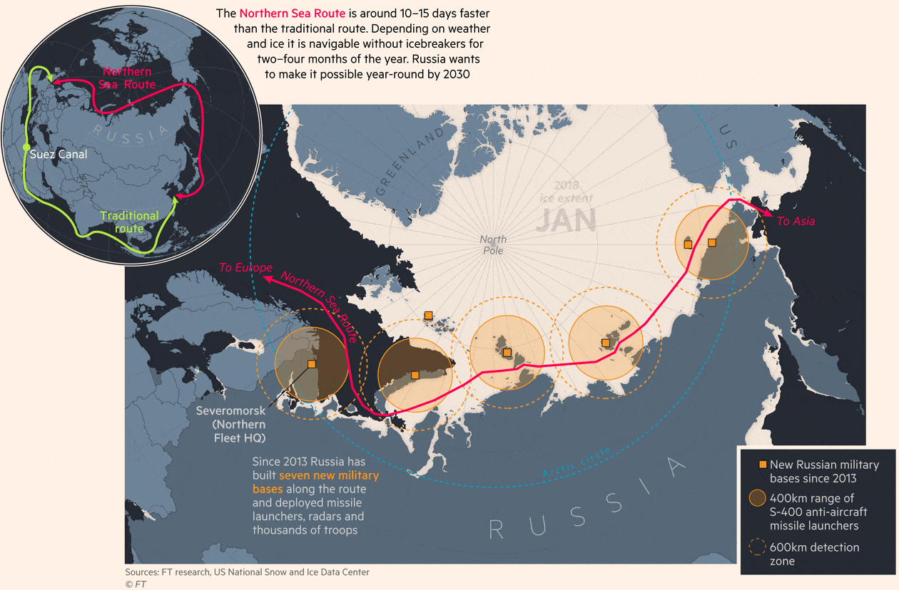
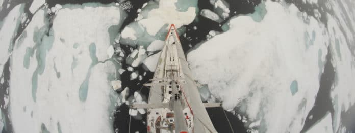
The Barents, whose waters lap Norway’s coast, marks the western boundary of the Northern Sea Route, a stretch of water encircling the North Pole that has for thousands of years remained mainly ice-bound, but whose rapid thaw has ushered in one of the world’s biggest emerging geopolitical flashpoints.
Fuelled by climate change that is rapidly shrinking the northern ice cap, the NSR has become an arena of growing competition.
Its potential as a preferential shipping route between Europe and Asia could change global trade flows.
The colossal hydrocarbon reserves that lie beneath it could upend energy markets.
And its growing militarisation has caught the attention of world powers.

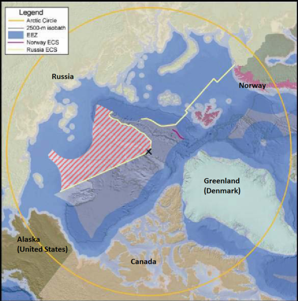
 Russia has an extensive sea bottom claim in the Arctic region.
The large hashed area reflects Russia's current extended continental shelf claim

While dozens of countries have begun staking claims to its riches, none has been as proactive as Russia in seeking to exploit the region, leaving others scrambling to keep pace.
One-tenth of all of Russia’s economic investments are currently in the Arctic region, Mr Putin said this month in St Petersburg.
Since 2013, Russia has spent billions of dollars on building or upgrading seven military bases on islands and peninsulas along the route, deploying advanced radar and missile defence systems — capable of hitting aircraft, missiles and ships — to sites where temperatures can fall below -50C.
It gives Moscow almost complete coverage of the entire coastline and adjacent waters.
The message is clear.
If you want to sail through the Arctic and travel to and from Asia faster, or have designs on the oil and gas assets beneath the sea, you will be under Russian oversight.
“The Americans think that only themselves can alter the music and make the rules,” Sergei Lavrov, Russia’s foreign minister, told the St Petersburg gathering.
“In terms of the NSR, this is our national transport artery.
That is obvious . . . It is like traffic rules.
If you go to another country and drive, you abide by their rules.” While traffic is light today, it is growing.
Experts estimate that during ice-free months, eastward shipment from Europe to China through the NSR is estimated to be around 40 per cent faster than the same journey via the Suez Canal, lopping hundreds of thousands of dollars off fuel costs and potentially cutting carbon dioxide emissions by 52 per cent.
At the moment the Arctic Ocean has just three ice-free months a year but several estimates suggest that number will increase in coming years, boosting access and driving up traffic.

Boosting Northern Sea Route shipping is a big part of the Arctic development plan.

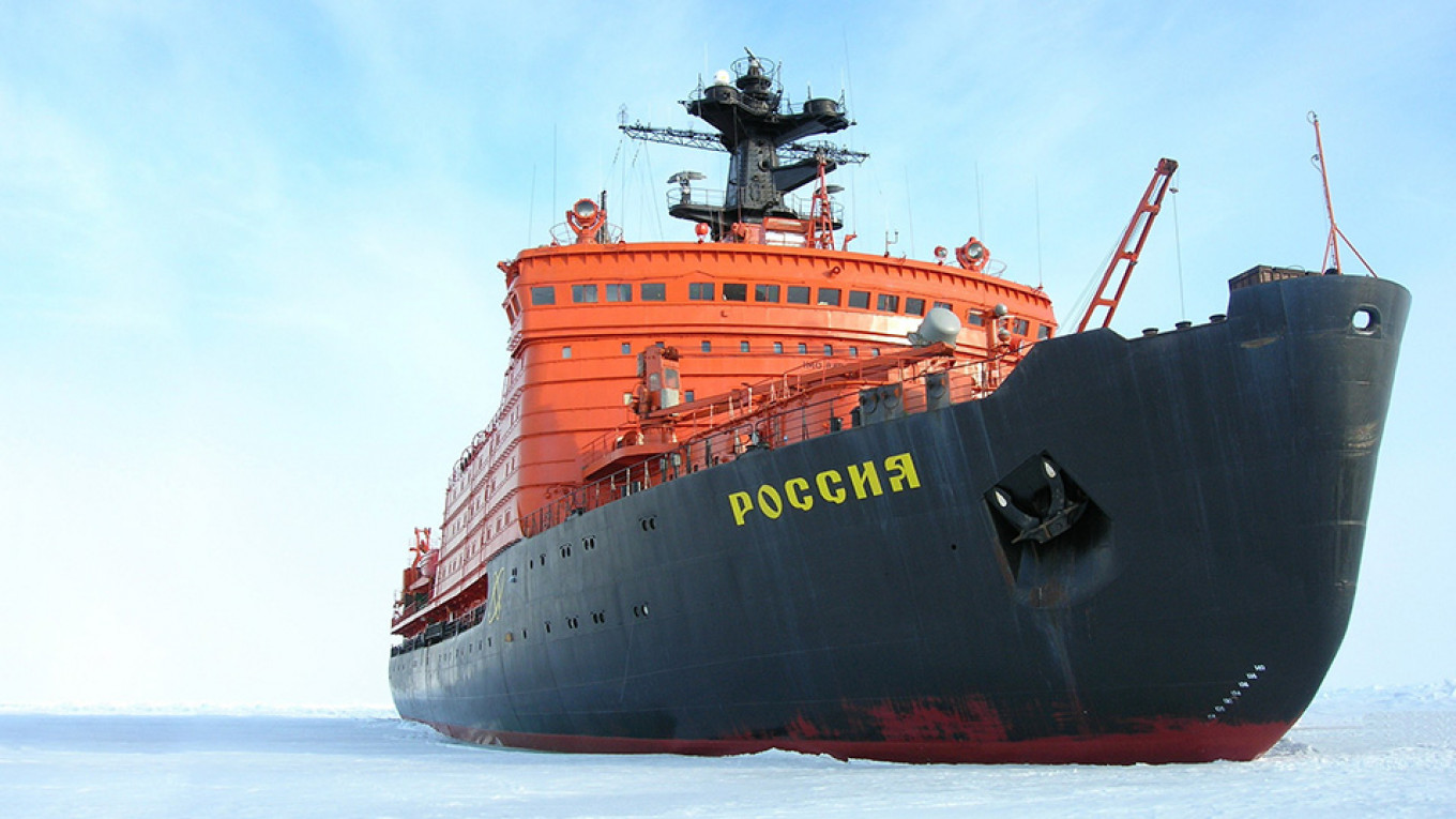
The 50 Let Pobedy nuclear-powered icebreaker, operated by Atomflot, smashing through the frozen waters of the Gulf of Ob In anticipation of a shipping boom, Russia has pushed through legislation to increase its control, including giving Rosatom, its state-owned nuclear power conglomerate, a monopoly over managing access to the NSR through icebreakers that can chaperone ships.
With a fifth of its land inside the Arctic Circle, Russia has gone in search of more territory, claiming that underwater ridges mean it should be granted another 1.2m square kilometres of the Arctic Ocean.
The UN Commission on the Limits of the Continental Shelf has recognised part of the neutral Arctic waters as a continuation of the Russian shelf.
As a result, the Mendeleev Rise and the Lomonosov Ridge may become Russian by the summer of 2020, says an official familiar with the talks.
Rivals are scrambling to catch up: This week the US announced it had ordered its first icebreaker for more than two decades, spending $746m on a ship to be ready in 2024.
“Against the backdrop of great power competition, the [ship] is key to our nation’s presence in the polar regions,” says Admiral Karl Schultz, commandant of the US Coast Guard, citing “increased commerce, tourism, research, and international activities in the Arctic”.
In 2007, Russian explorers planted a titanium white, blue and red tricolour flag on the seabed below the North Pole.
That act, the most audacious and theatrical part of a bid to claim the Pole, came almost 300 years after Russia’s Arctic exploration began.
Expeditions ordered by Peter the Great first mapped out an Arctic coastline of around 24,000km — roughly the same length as Russia’s entire land borders.
Russia built the world’s first icebreaker, the Yermak, 120 years ago.
In 1957, it built the first nuclear-powered version, the Lenin.
Its Arktika icebreaker was the first to reach the North Pole in 1977.
“Little has changed essentially in those years, both in the shape of the frame and the inside components,” says Sergei Frank, head of state-owned shipping company Sovcomflot.
During the cold war, the Soviet Union threw huge resources at the region.
The Northern Fleet was the largest in the Soviet Navy, and Arctic air bases provided refuelling points for nuclear-capable bombers.

Western powers settled for containment, with Nato forces patrolling the gaps between Greenland, Iceland and the UK in a bid to prevent Soviet submarines armed with ballistic missiles from passing into the Atlantic undetected.
But as the Soviet economy crumbled, the Arctic infrastructure steadily fell into disrepair.
Expensive to maintain and lacking a strategic rationale, Moscow slowly shifted focus.
Climate change and the growing power of Asian economies have changed that calculation.
Arctic ice has shrunk by 12.8 per cent a decade on average since 1979, according to Nasa data, and last year’s September ice cover was 42 per cent lower than in 1980, turning a frozen, secure northern border into a hotbed of potential exploitation and conflict.
Last year Russia’s Northern Fleet conducted its largest military exercise for a decade.

“Russia simply doesn’t have another ocean,” the country’s natural resources minister, Dmitry Kobylkin, said last week.
“All projects implemented in the Arctic are our future horizons.” But where Moscow sees a security challenge, other countries see opportunity.
Last August, Danish shipping major Maersk ran a trial shipment along the NSR, when the Venta Maersk ferried electronics, minerals and 660 containers of frozen fish from Vladivostok to St Petersburg.
The first-ever NSR transit by a container ship, which Maersk says was a “one-off trial” to gain experience, was chaperoned by a Russian icebreaker along most of the country’s north-eastern coastline.
Ships from 20 different countries plied the waters of the NSR last year, carrying a total of 20m tonnes of cargo.
While paltry in comparison to traditional global shipping routes, it is double the amount in 2017, and Russia expects that figure to quadruple by 2025.
“This is a realistic, well-calculated and concrete task,” Mr Putin said this month.
“We need to make the Northern Sea Route safe and commercially feasible.” Rosatom says the cargo target could be beaten, provided it receives new icebreakers on time.
“Life doesn’t end there,” says Alexei Likhachev, Rosatom’s head.
“We are aiming for 92.6m tonnes in transit by 2024 rather than 80m tonnes.
And by 2030, we hope to add a significant part of international transit to that.” China’s increased interest in the Arctic, and its developing friendship with Russia, will be critical in hitting that target.

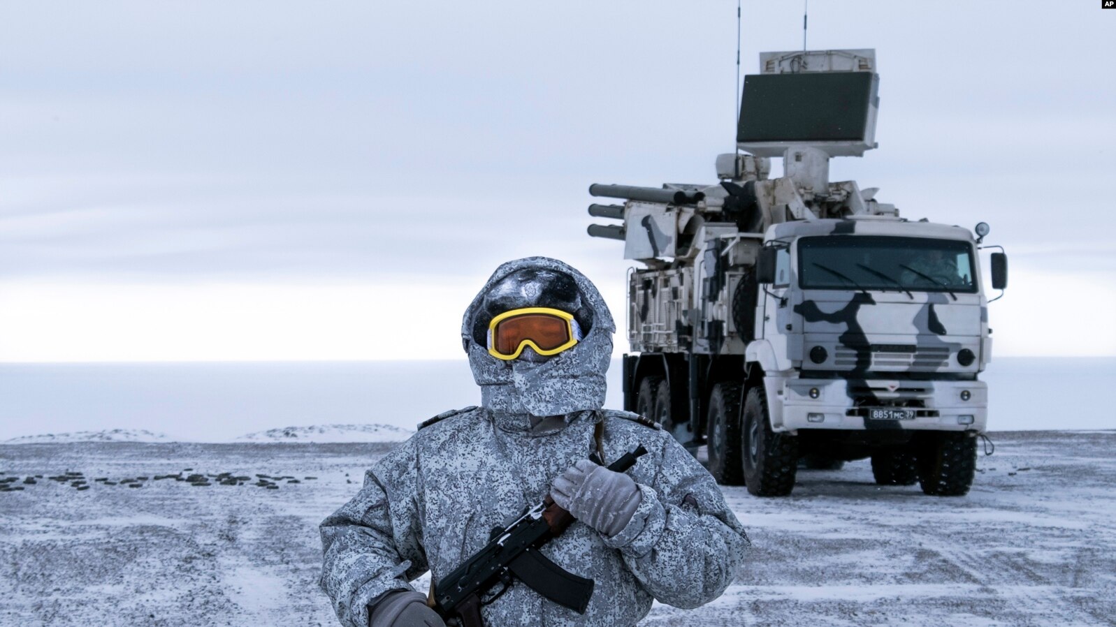
In this photo taken on April 3, 2019, a Russian solder stands guard near a Pansyr-S1 air defense system on the Kotelny Island, part of the New Siberian Islands archipelago located between the Laptev Sea and the East Siberian Sea, Russia.

Beijing has observer status on the Arctic Council, a body designed to manage regional co-operation; has a research station on the Norwegian archipelago of Svalbard; and is the biggest foreign shareholder in Russia’s Arctic liquefied natural gas projects, which will rely on NSR shipments for exports.
Last year, China published an Arctic policy paper that explicitly linked the NSR to its ambitious Belt and Road strategy of developing pathways for both trade and influence, dubbing it the “Polar Silk Road”.
“I remember that just two decades ago people were saying [the NSR] was impossible,” says a foreign ambassador in Moscow.
“But when I heard the term Polar Silk Road and realised the Chinese were interested, I knew it was serious.” Shipping companies from South Korea, where many of Russia’s cargo tankers are built, have also conducted pilot voyages since 2013.
“South Korea and other Asian countries consider the NSR the shortest shipping route linking Asia and Europe and one of great commercial potential,” says Park Heung Kyeong, ambassador for Arctic affairs for Seoul’s foreign ministry.
Yet turning potential into profit will not be easy.
Ships often require an escort from an icebreaker as a precaution even when the NSR is ice-free.
“This is a very difficult and technologically intense task because we exist in a very competitive environment,” says Maxim Akimov, Russia’s deputy prime minister.
Russia has the world’s only fleet of nuclear icebreakers.
All but one of its four-strong fleet will be replaced over the next decade at an estimated cost of between $500m and $1.5bn each.
By 2035, its Arctic fleet will include least 13 icebreakers, including nine nuclear powered vessels, according to Mr Putin.

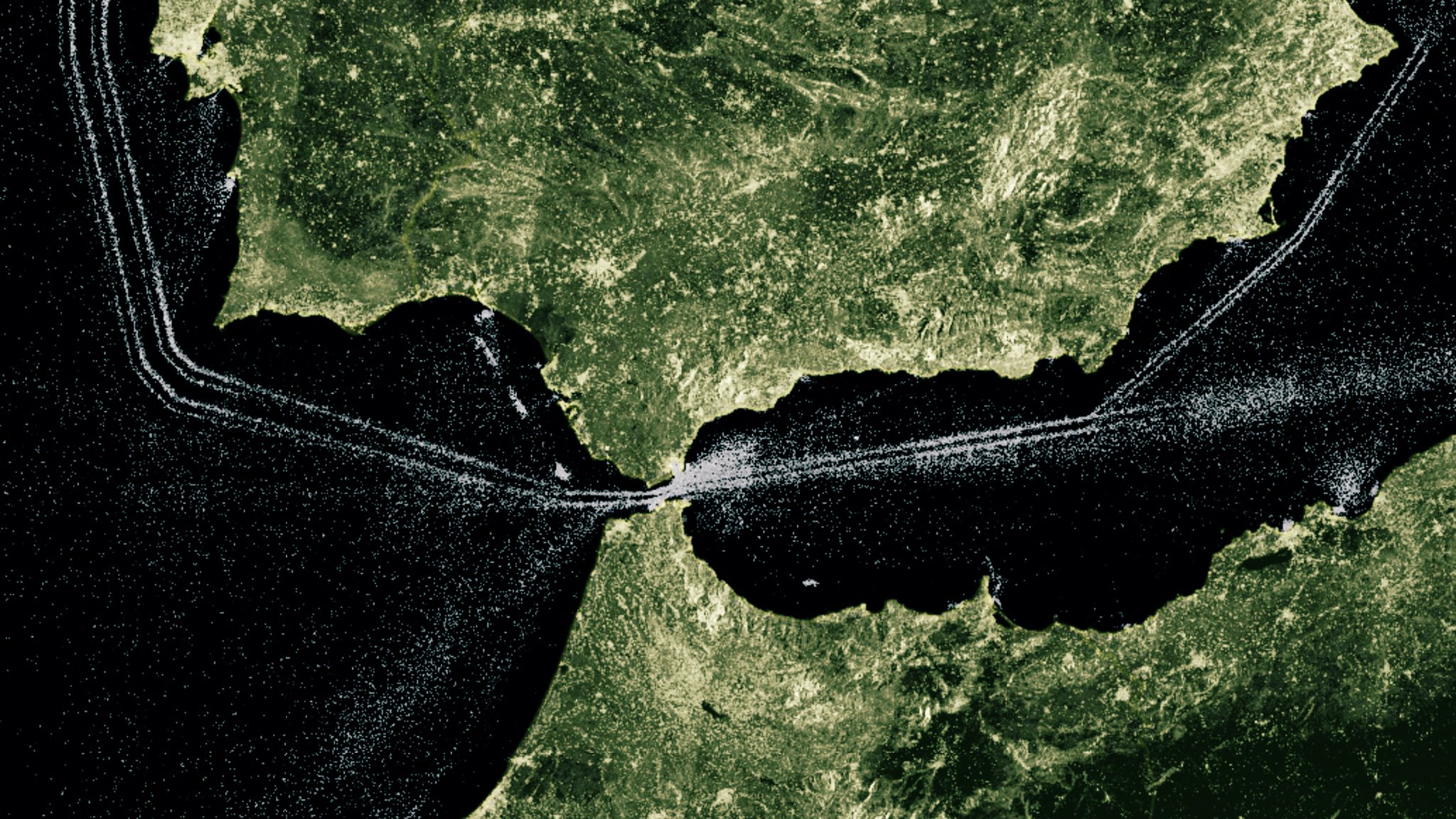
Moscow also needs to expand and develop ports at both ends of the route — Murmansk close to the Norwegian border and Petropavlovsk-Kamchatsky on the Kamchatka Peninsula near Japan — and has invited foreign companies to invest in the projects.
“We are convinced that there is demand for the NSR and plan to implement the project with the help of broad international partnerships,” says Rosatom.
At the St Petersburg conference, the most commonly used word among foreign officials was “co-operation”.
Although senior representatives from Canada and the US were conspicuous by their absence, presidents, prime ministers and top diplomats from European Arctic powers were at pains to make clear they wanted to work with Moscow.
Indeed they might.
Russia’s rapid and determined push to assert its control over the NSR has unnerved many of its Arctic neighbours, which are now seeking to collaborate with the Kremlin.
Complicating the issue is the soured relationship between Russia and the west, due to Moscow’s 2014 annexation of Crimea, the attempted assassination of a former spy in the UK last year and efforts to meddle in foreign elections.
Those factors, and the resulting sanctions levied by western countries, mean some governments are tentative about working closely with Moscow on commercial or security issues, and have instead focused on areas such as environmental protection and safety.
Without action to mitigate human sources of greenhouse gas emissions, the Arctic Ocean could be ice-free during the summer months before 2050, and possibly within the next decade or two, a UK parliament defence committee report warned last year.
“We want to have good relations with Russia, but at the same time we do not give up on the things which we believe in and things which we look at differently,” Sweden’s prime minister Stefan Löfven told Mr Putin on stage in St Petersburg.

Marie-Anne Coninsx, the EU’s ambassador-at-large for the Arctic, denies that Brussels had been slow to react to the region’s potential.
“We have for many years been engaged with the Arctic,” she says.
“We are co-operating well with Russia — co-operation not competition.” Brussels is working with Moscow on issues ranging from water waste management to the treatment of nuclear waste in the region, she adds.
“The EU’s member states have the biggest merchant fleet in the world,” Ms Coninsx says.
“If there are new economic opportunities, they will be used.” But the west’s other response was illustrated last October, when Nato troops carrying assault rifles poured out of landing craft on to beaches in northern Norway.
Operation Trident Juncture was the military alliance’s largest war games since the cold war, and saw 50,000 troops, 10,000 vehicles and 250 aircraft from 31 countries participate in a four-week long exercise close to the country’s border with Russia.
Condemned by Moscow as aggressive posturing, analysts said it illustrated how seriously Nato took Russia’s ambitions in the frozen north, and its understanding that its troops needed experience of operating in the region.
Russia is “staking a claim and militarising the region”, UK defence secretary Gavin Williamson said last September as he announced the country’s new Arctic defence strategy.
“We must be ready to deal with all threats as they emerge.”

Around 800 Royal Marines troops are training in Norway this year, while four RAF Typhoons are patrolling in the skies above Iceland for the first time.
The US is expected to release a new Arctic strategy this summer, a document that the Pentagon has said will focus on how to “best defend US national interests and support security and stability in the Arctic”.
“Russia’s development of its Arctic areas . . . gets immense attention, and that creates both fair and unfair competition, which is pure politics,” says Konstantin Kosachev, chairman of the foreign affairs committee at Russia’s upper house of parliament.
That challenge of balancing defence and development is the biggest question facing Russia, says Chris Tooke, analyst at GPW, a political risk consultancy.
Moscow helped Arctic gas producer Novatek by relaxing a requirement that only Russian-registered vessels can traverse the NSR which would have dented its export potential.
But Mr Tooke believes such steps will be rare.
“On balance, I would expect security imperatives to trump commercial interests, and this tension and the need to develop infrastructure will probably slow progress in commercial exploitation in the medium term,” he says.
“But the potential is definitely there.”

Links :

Wednesday, May 1, 2019

Screw the box

Stig Pryds is a Danish record holding freediver.
He was diagnosed with psoriatic arthritis in 2008, which disabled him so much that he lost his business.
After 5 years of intense pain and increasing dependency on drugs, he decided to quit all drugs cold turkey, and find alternative ways to deal with his disease.
He began practising yoga daily, changed his diet, and started practising freediving.
This caused drastic changes: within months he could walk without a cane, and he could play with his two young daughters again.
It also taught him how good he actually was at freediving; within a year he started setting Danish records.
He started traveling the world going to freediving competitions, where the warm weather and sun also improved his condition.
He used his increased exposure from the Danish records to tell the story of his recovery and inspire people to live a healthy lifestyle.
He started teaching others how to deal with auto-immune disorders.
The downside of his new fame was that the insurance company, who paid his monthly disability check, noticed that he was doing things a healthy person does.
Despite the argument that he's only healthy because he can do these travels and trainings, the insurance company threatened to sue him for lying -he'd have to pay back all the disability checks plus a fee.
With the help from his doctors Stig managed to convince them his disease is real, just that he manages it well, but the insurance company decided to stop paying him his disability.
The stress this whole procedure caused was enormous and Stig relapsed into severe pain.
We shot this video in January, the hardest month for Stig, where he had to figure out how to proceed.
We talked about how life can keep dealing you blow after blow, and how you know that you'll be ok anyway.
But it still sucks that you have to deal with the blows, and have to go through that uncertainty of what comes next.
Stig has decided to focus on his new breathing program, in which he teaches people how to breathe properly to deal with stress and disease, together with yoga and diet.
He might not be able to compete much this year, but he's getting back up and doing his best to be of use to others.
Find out more about Stig here: https://www.stigpryds.com/

Tuesday, April 30, 2019

Winds and waves on the oceans are getting (slightly) stronger every year

Global trends in extreme (90th percentile) wind speed over the period 1985-2018.
Areas in red indicate increasing values, whereas blue indicates decreases.
Credit: Professor Ian Young
 Global trends in extreme (90th percentile) wave height over the period 1985-2018.
Areas in red indicate increasing values, whereas blue indicates decreases.
Credit: Professor Ian Young, University of Melbourne

From DiscoverMag by Bill Andrews

In the world of climate science — and science in general — data is king.
The more of it you have, and the higher its quality, the better.
And while such trends as the rise in temperatures and sea levels have impeccable data behind them, not every measure of a changing climate has been so lucky.

Take the global wind and wave climate, for example, which measures trends in wind speed and wave height in oceans around the globe.
Both of these factors affect the interplay between the atmosphere and ocean of both energy and carbon (more winds equal choppier waters, which can get in the way of air-to-water energy transfers), and of course higher waves could spell more trouble during storm surges and affect flooding levels.
But it had been historically tricky to get reliable long-term data on these phenomena to study any possible trends.

Until now, that is.
A paper in Science today uses satellite data to analyze wind speed and wave height over more than 30 years, and concluded that on average both are increasing, especially in the southern hemisphere, and especially during extreme conditions like storms.
They also demonstrated a useful way to study these things in the first place, which should prove helpful to scientists moving forward.

Image: Changes in wave power in different oceans over time, Nature.

Defective Data

Why did it take till now to amass and analyze what should be a fairly straightforward dataset?
As the paper’s authors explain, it wasn’t that easy.
Ocean buoys, “the most obvious data source,” have proven problematic because changes over the years in their construction and instrumentation mean the data they’re spitting out isn’t really consistent in the long term.
So it’d be comparing apples to, if not oranges, then at least other kinds of apples — not ideal.

Thus, they turned to the satellite record, which currently runs from 1985 through 2018.
Not bad, but the same worries came up there, too: With all the different kinds of hardware and software in space, maybe their data isn’t reliable enough for such research either?

So, the authors decided to go in and find out.
As you may have surmised by now, it worked out.

 credit picture : Ameen Fahmy (unsplash.com)

Going Up

In particular, they studied the data collected by three kinds of instruments on satellites: altimeters, which measure both wave height and wind speed; radiometers, which measure wind speed; and scatterometers, which measure wind speed and direction.

After cross-checking all the numbers, cross-validating with other satellites and just generally making sure they weren’t being fooled by anything, the authors concluded that these past 30-odd years had seen a strong positive trend in global wind speed, and a weaker (but still noticeable) increase in wave heights.
They also noted the trends were much stronger in extreme cases, which they defined as the data from the set’s 90th percentile.

Not that any of the actual changes were especially high.
Wind speeds went up by about an inch per second every year — about twice the speed of a garden snail — across the Southern Ocean and south of the equator, where the trends were strongest.
The change was about half that in the North Atlantic.
(The extreme cases had the same distribution, but with faster speeds, around two inches per second per year.)
Things weren’t quite as clear cut for wave height, but there were patches with overall rises of about a tenth of an inch per year, and one surprising spot in the North Pacific with a drop of about half an inch per year.

MODIS satellite image (21/05/2010)

Closing in on Climate

It might not sound like much, fractions of an inch here or there, but the results do show clear trends for global behavior over time.
Any improvement on our understanding of the global wind and wave climate is helpful, the authors write, since “estimates of future ocean wind and wave states, and whether extreme conditions are changing, are important elements of projections of total sea level.”

The team also showed that the satellites can be trusted, since each of the different kinds of instruments, aboard 31 total orbiting satellites, ultimately showed data consistent with each other.
This means future studies can rely on this increasingly rich data set without having to worry about comparing apples to anything else.

So not only did the authors add some specific bits of that all-important data to the global climate record, they also made it easier for future researchers to do the same.

Links :

Monday, April 29, 2019

Around-the-World expedition finds 200,000 species of viruses in the oceans

Samples being collected.
 The research, led by scientists at the Ohio State University, has wide-ranging implications, from evolution to biotechnology to climate change.
(A. Deniaud/Fondation Tara Ocean)

From Gizmodo by Ryan F. Mandelbaum

After traveling around the world, sampling the ocean from pole to pole, scientists have uncovered nearly 200,000 populations of marine viruses.

In the marine ecosystem, tiny living things called microbes make up most of the ocean’s biodiversity and over half of its biomass.
But much less is known about the viruses—packets of genetic information that replicate inside other living things—that exist in the oceans.
Scientists set out to study the marine viral community, its diversity, and its function, especially how it impacts microbes.
On Thursday, they announced the creation of an enormous, global catalog of marine viruses, marking an important step in answering many of these questions.
“It expands our knowledge of what the biological entities on our planet are,” Ann Gregory, study author and postdoctoral researcher at VIB-KU Leuven in Belgium, told Gizmodo.

 The Tara.
A rotating team of scientists boarded a sailboat called the Tara between 2009 and 2013 and collected water samples from varying depths across many geographical regions.
Those samples were then filtered and shipped to dozens of different labs that are part of an effort known as the Tara Oceans Consortium. 
(A. Deniaud Garcia/ Fondation Tara Ocean)

The data comes from 146 samples taken on several expeditions aboard the the schooner Tara, including 41 samples from a 2013 trip to the Arctic Ocean.
The researchers first needed to identify whether the genetic material in the sample was viral or not, with various bioinformatic tools comparing it to known viruses, explained study co-author Ahmed Zayed, graduate student at the Ohio State University.
Then, they compare the DNA strands to one another in order to divide them into viral populations.


Examples of virus species from the new survey.
The new revelations about biodiversity in the Arctic are important because they provide a starting point for further research in the region -- one of the hardest hit by climate change.
Now that scientists know the Arctic is home to so many species of viruses, they can investigate why exactly that is and how much of that biodiversity will be lost as climate change continues to affect the region, Sullivan said.
The research also creates a massive data set that has biotechnological implications.
"Viruses tend to steal genes and do really interesting things with them.
So someone who's savvy in biotechnology can mine this data set to find new enzymes that can help us in our everyday lives, whether that's cosmetic products or creating a new thermocycler or some sort of engineering process," Sullivan explained. 
Image credits: Jennifer Brum.

The analysis revealed 195,728 populations of viruses, 12 times more than the previous analysis on a smaller Tara dataset, according to the paper published in Cell.
A closer look revealed that these populations seem to sort into five meta-communities, which the researchers call ecological zones: Arctic; Antarctic; deeper than 2,000 meters; 150 to 1,000 meters; and temperate/tropical waters with depths of 0 to 150 meters.
Perhaps surprisingly, latitude didn’t predict viral diversity.

 Matthew Sullivan, a microbiologist at the Ohio State University and one of the study's authors, called it a road map to understanding how viruses affect ecosystems in the ocean.
"Having that road map helps us do a lot of the things we'd be interested in to better understand the ocean and, I hate to say it, but maybe to have to engineer the ocean at some point to combat climate change," Sullivan told.
Jennifer Brum and Matt B. Sullivan / Lab. Ohio State

It’s an exciting piece of work.
Microbes are perhaps the key drivers of the ocean’s biochemical processes, and microbes are infected by viruses.
“I think that people are aware that viral diversity far exceeds that of the vast microbial diversity,” Alison Buchan, professor at the University of Tennessee, Knoxville, told Gizmodo.
“But there have not been a great number of studies that have tried to quantify the extent of that diversity.”

 The study revealed that viruses are organized into five distinct ecological zones throughout the ocean.
It also revealed new hotspots of biodiversity -- areas that are rich in species but also under threat from human activity.
Some of the most surprising hotspots they found were in the Arctic Ocean. 
The study could also help scientists better understand how viruses affect Earth's atmosphere -- and how viruses can help mitigate the effects of climate change, Sullivan said.
Marine organisms produce half the oxygen we breathe, and the ocean removes half the carbon dioxide that humans emit into the atmosphere, acting as what Sullivan calls a "climate change sponge."
That process is largely driven by viruses.
Through this research, Sullivan said, scientists could potentially engineer oceans to fight climate change -- meaning they could manipulate viruses in a way that would remove even more carbon dioxide from the air.
"There's a lot of understanding that needs to happen to do that in a societally responsible way, but I think that this kind of study provides quite a foundation to start thinking in that manner," Sullivan said.
© François Aurat / Tara Foundation

What do you do with such a large dataset?
Mainly, you research it to try to better understand the roles of all these viruses.
Like how the rabies virus can increase the aggression of an infected animal to facilitate transmission, maybe some of these viruses are important for the ocean’s chemical processes.
Many of them also lead to the death of the microbes.
And maybe this vast new store of genetic information contains something that will be useful to humans.
“Perhaps you can mine it for new genes,” Gregory said. May researchers will discover novel antibiotics using this genetic information.

What you didn't know about viruses in the ocean | Karen Weynberg
Marine viruses are the dark matter of the world's oceans.
We know more about deep space than we do of the viruses we share Planet Earth with.
Together, let's unlock the secrets of this microscopic world that undoubtedly holds great potential for discovery.

This dataset is certainly not comprehensive, Gregory and Zayed warned.
It includes only viruses that contain DNA, rather than those that contain RNA (somewhat simply, DNA is composed of a pair of complimentary strands of genetic material, while RNA is composed of a single strand).
Buchan also noted that it’s more of a snapshot in time. Six months later, they might have collected different results, she said.

This research is a great reminder that, as much as we know about life on Earth, the oceans remain full of unknowns.

Links :

Sunday, April 28, 2019

This is the most over-fished sea in the world

The Mediterranean supports countries in Europe, the Middle East and North Africa—but its fish stocks are almost completely collapsed.
Meet the man who is leading attempts to revive its marine habitats. 
This is the extraordinary story of one man’s dream to save the most over-fished sea in the world. Zafer Kizilkaya has almost single handedly turned a ravaged bay in Turkey into one of the most effective and thriving marine conservation areas in the Mediterranean.
His hope is to inspire others to bring marine life back to one of the most famous but damaged parts of the ocean.
It’s a chilly December morning on Turkey’s eastern-Mediterranean coast and Zafer Kizilkaya is a man on a mission.
He’s dedicated to enforcing the no-fishing zones that he has helped create here in Gokova Bay.
Within just 20 minutes Zafer and one of his rangers have spotted something suspicious.
Since marine conservationist Zafer set up the ranger system here in partnership with the Turkish authorities they’ve seen a significant drop in illegal fishing.
It all began after Zafer first visited Gokova Bay in 2008 on a research trip from his home city of Istanbul.
The damage he witnessed to marine life compelled him to stay and devote his life to repairing this.
Zafer lobbied his government to make the bay a protected area and ten years on his research suggests marine life has increased by 800% within his no-fishing zones.
But the revival faced another threat new species of fish coming into the Mediterranean through the Suez Canal.
These invaders were eating the native fishes’ food and grazing parts of the seabed bare so Zafer had to adapt and come up with an innovative solution.
To make this work, he had to hook the local population into eating these unfamiliar fish and that meant persuading people to change their diets.
Zafer’s vision has delivered the bonus of raising the incomes of local fisher people by 400% and bringing a previously decimated industry back to life.
Visit the fishing co-operative here and you’ll find an array of invasive species for sale caught outside the no-fishing zones.
Zafer’s innovations have delivered for both people and planet in this small bay and he’s now working to create another marine protected area in Turkey.
It looks like a lonely mission.
Latest figures show just 0.04% of the Mediterranean is a no-fishing zone 50 times lower than the average for the whole ocean.