Always wanted to be an astronaut, but never quite made it to space?
A new site can at least make you feel like you went. Glittering Blue is a beautiful, simple website that shows 24 hours of observations of Earth from the Japanese weather satellite Himawari-8 like you’ve never seen before.
It’s in stunning high-definition and gives a glimpse at what you might see if you were stationed 22,300 miles above the equator.
The 12-second clip is a time-lapse of one section of the globe, constructed from a number of photos taken by the Japanese Himawari 8 satellite over a 24-hour period.
It shows the Earth as the sun rises over the western Pacific , travels past Australia (somewhere about here) and eventually sets on the other side.
The clip also shows a Category 5 typhoon captured in pictures that day -- August 3, 2015 -- called Typhoon Soudelor.
Built by Charlie Loyd, who works on satellite imagery at Mapbox, the process used to create the beautiful animation is open source.
Loyd says that “Himawari-8 has the best sensor of its kind in space today” and that it’s how Earth “really looks” over 24 hours… except sped up.
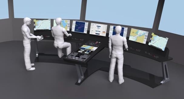
Drawing directly from the experience of seafarers, the E.U.-funded project CASCADe has developed new adaptive bridge displays and design methodologies that treat humans and electronic equipment as parts of a cooperative system.
To date, the development of ship bridge systems is characterized by being non-harmonious and far from guaranteed to be of optimal design for the actual users of them. Existing regulations for system and procedure design are disconnected and defined on a level which is not informative for bridge design. Research has shown clearly, that in many cases, accidents and incidents were caused by human error due to non-optimal design of the human-machine interaction leading to degraded situation awareness.
CASCADe addressed the design of bridges as an integrated whole with holistic perspective that allowed the detection and solving of potential conflicts including human error and inconsistencies and redundancies in the information presented on screens.
Beside cognitive ergonomics, CASCADe also pays deep attention to physical ergonomics and to the interplay between physical postures, physical moves and cognitive behavior and communications on the bridge.
The three-year project, which is coming to a close this month, then developed a set of adaptive bridge displays including a touch screen “Shared Display” intended to aid communication and co-operation on the bridge. This tool is fully customizable and allows one screen to show multiple sources of information in whatever configuration is most suitable for a particular situation.
Pilot with PPU - Adaptative perspective display, shared for cooperation and bridge layout
seen as an integrated whole
"It offers functionality to graphically annotate maps, leave notes for other crew members or complete checklists electronically."
The “Shared Display” provides functionality to graphically annotate maps, leave notes for other crew members or complete checklists electronically.
The CASCADe console was integrated with tools used by pilots in their Portable Pilot Units (PPUs). Firstly, CASCADe developed a protocol to share pilotage routes between the PPU and the ship’s electronic charts. Secondly, a link was established between the PPU and the bridge screens to allow mirroring of information from the PPU screen, enabling crew members to see extra information normally only available to the pilot.
All of these CASCADe tools were tested on both a physical simulator (a ship simulator used for training) and a virtual simulator (a software-based simulation of a ship bridge). The virtual simulation platform made it possible to test new bridge designs at the earliest stages of development, based purely on computational models.
The final evaluation of the CASCADe results took place in Kiel, Germany, late last year. The new ship bridge (including the handover and annotation tools) was presented to a group of nine local pilots, officers and cadets. The feedback was generally positive.
Under the coordination of OFFIS (Oldenburg Research and Development Institute for Information Technology Tools and Systems), CASCADe included a consortium of seven project partners from five E.U. countries including BMT Group, Raytheon Anschuetz, Mastermind Shipmanagement, the University of Cardiff, Marimatech and Symbio Concepts & Products.
Four further associated partners including the Maritime Cluster Northern Germany, Nautilus International, NSB Niederelbe Schiffahrtsgesellschaft mbH & Co. KG and the University of Tasmania also supported the project.
NOAA archaeologists have discovered the battered hulls of two 1800s
whaling ships nearly 144 years after they and 31 others sank off the
Arctic coast of Alaska in one of the planet's most unexplored ocean
regions.
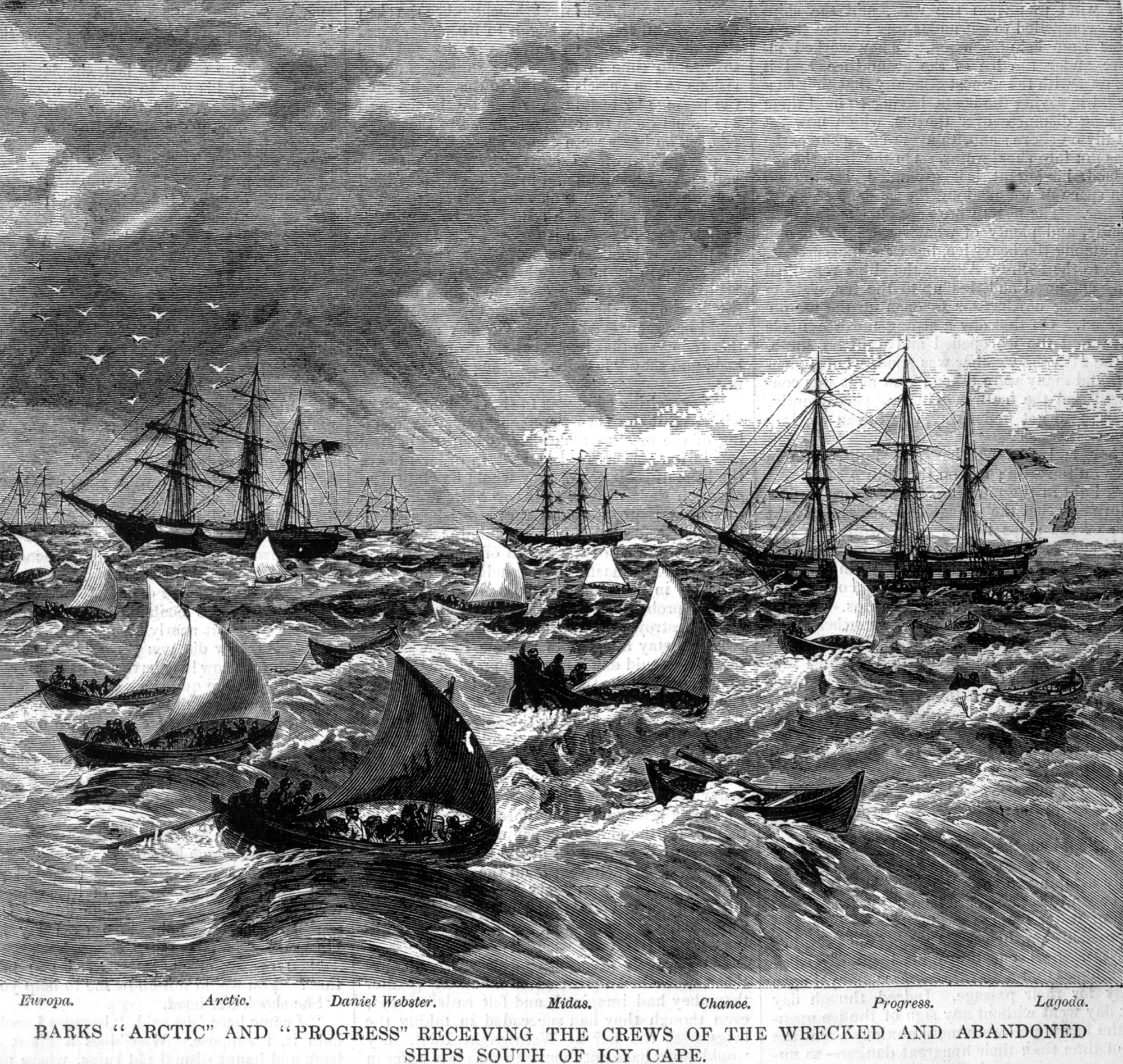
Abandonment of the whalers in the Arctic Ocean, September 1871, including the George, Gayhead, and Concordia.
Scanned from the original Harper’s Weekly 1871, courtesy of Robert Schwemmer Maritime Library.
The shipwrecks, and parts of other ships, that were found are most
likely the remains of 33 ships trapped by pack ice close to the Alaskan
Arctic shore in September 1871.
The whaling captains had counted on a
wind shift from the east to drive the ice out to sea as it had always
done in years past.
The ships were destroyed in a matter of weeks, leaving more than
1,200 whalers stranded at the top of the world until they could be
rescued by seven ships of the fleet standing by about 80 miles to the
south in open water off Icy Cape.
No one died in the incident but it is
cited as one of the major causes of the demise of commercial whaling in
the United States.
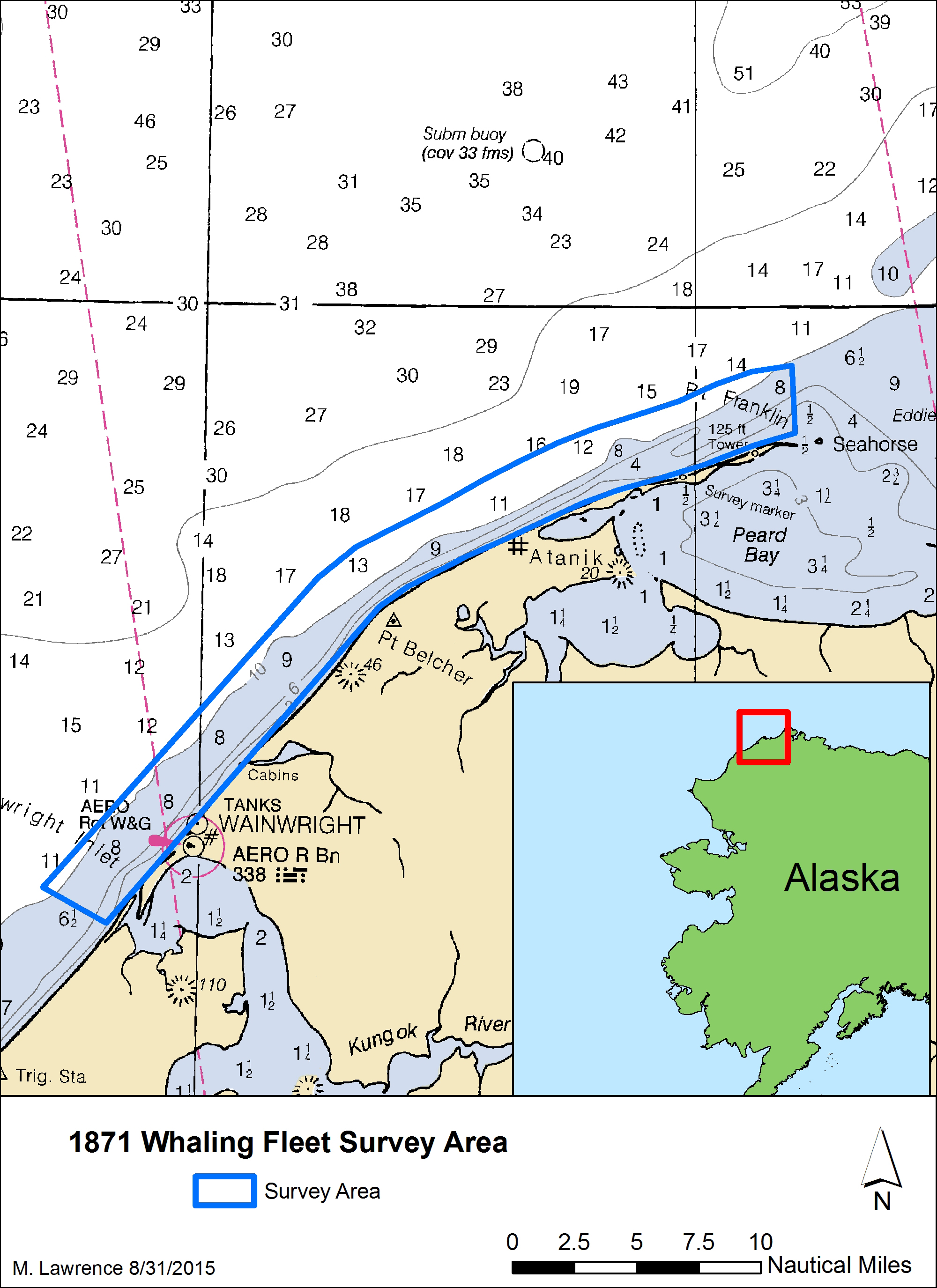
This map shows the area that was surveyed during the Search for the Lost Whaling Fleets expedition. Image courtesy of M. Lawrence/NOAA.
With less ice in the Arctic as a result of climate change,
archaeologists now have more access to potential shipwreck sites than
ever before.
In September, a team of archaeologists from the Maritime
Heritage Program in NOAA's Office of National Marine Sanctuaries scoured
a 30-mile stretch of coastline in the nearshore waters of the Chukchi
Sea, near Wainwright, Alaska.
Previous searches for the ships had found
traces of gear salvaged from the wrecks by the local Inupiat people, as
well as scattered timbers stranded high on the isolated beaches that
stretch from Wainwright to Point Franklin.
The shipwreck remains located off Point Franklin represent 19th century
wooden ship construction. The wood frames are likely from the lower
portion of the vessel near the turn of the bilge.
The wooden pegs, seen
here on a section of ship hull, are known as treenails and were used to
fasten pieces of wood together, and in this case they were used to
attach the exterior hull planking or interior ceiling planks.
Image courtesy of Robert Schwemmer/NOAA .
Using state-of-the-art sonar and sensing technology, the NOAA team
was able to plot the "magnetic signature" of the two wrecks, including
the outline of their flattened hulls.
The wreck site also revealed
anchors, fasteners, ballast and brick-lined pots used to render whale
blubber into oil.
"Earlier research by a number of scholars suggested that some of the
ships that were crushed and sunk might still be on the seabed," said
Brad Barr, NOAA archaeologist and project co-director.
"But until now,
no one had found definitive proof of any of the lost fleet beneath the
water. This exploration provides an opportunity to write the last
chapter of this important story of American maritime heritage and also
bear witness to some of the impacts of a warming climate on the region's
environmental and cultural landscape, including diminishing sea ice and
melting permafrost."
James Delgado, maritime heritage director for NOAA's Office of
National Marine Sanctuaries, said he believes the wrecks were pressed
against a submerged sand bar that rests about 100 yards from shore.
Working from first-hand accounts of the loss of the fleet, he said the
ice opened the hulls to the sea and tore away the upper portions of the
ships, scattering their timbers on the beach, while the lower hulls,
weighted down with ballast, and in some cases still anchored, stayed in
place against the sand bar.
"Usually, the Arctic does not destroy ships if there is a natural
obstacle like a sand bar, large rocks or a sheltered cove to partially
divert the force of tons of ice," Delgado said.
Abandonment of the whalers in the Arctic Ocean, September 1871,
including the Monticello, Kohoa, Eugenia, Julian, Awashonks Thom
Dickason, Minerva, Wm. Rotch, Victoria, and Mary.
Wainwright Inlet is in
the background.
Courtesy of Ted and Ellie Congdon, Huntington Library.
On Sept. 12, 1871, the captains of the 33 whaling ships caught in the ice convened aboard the Champion
to consider their options for saving the 1,219 officers, crew, and in
some cases, families, from their fate.
Although, their situation was
dire, there was some small glimmer of hope for rescue by seven nearby
ships.
However, to save such a large party, the rescuing whale ships had to
jettison their precious cargoes of whale oil, bone and their expensive
whaling gear to make room for the survivors.
The rescue ships were able
to sail safely out of the Arctic and back to Honolulu, where hundreds of
native Hawaiian whalers aboard the stranded vessels lived, while others
sailed on to San Francisco, New Bedford and other cities.
The current strong El Niño brewing in the Pacific Ocean shows no
signs of waning, as seen in the latest satellite image from the
U.S./European Ocean Surface Topography Mission (OSTM)/Jason-2 mission.
El Niño 2015 has already created weather chaos around the world.
Over
the next few months, forecasters expect the United States to feel its
impacts as well.
The latest Jason-2 image bears a striking resemblance to one from
December 1997, by Jason-2's predecessor, the NASA/Centre National
d'Etudes Spatiales (CNES) Topex/Poseidon mission, during the last large
El Niño event.
Both reflect the classic pattern of a fully developed El
Niño.
The images show nearly identical, unusually high sea surface heights
along the equator in the central and eastern Pacific: the signature of a
big and powerful El Niño.
Higher-than-normal sea surface heights are an
indication that a thick layer of warm water is present.
People the world over are feeling, or soon will feel, the effects of the
strongest El Niño event since 1997-98, currently unfolding in the
eastern equatorial Pacific Ocean.
New satellite observations are
beginning to show scientists its impact on the distribution of rain,
tropospheric ozone and wildfires around the globe.
El Niños are triggered when the steady, westward-blowing trade winds
in the Pacific weaken or even reverse direction, triggering a dramatic
warming of the upper ocean in the central and eastern tropical Pacific.
Clouds and storms follow the warm water, pumping heat and moisture high
into the overlying atmosphere.
These changes alter jet stream paths and
affect storm tracks all over the world.
This year's El Niño has caused the warm water layer that is normally
piled up around Australia and Indonesia to thin dramatically, while in
the eastern tropical Pacific, the normally cool surface waters are
blanketed with a thick layer of warm water.
This massive redistribution
of heat causes ocean temperatures to rise from the central Pacific to
the Americas.
It has sapped Southeast Asia's rain in the process,
reducing rainfall over Indonesia and contributing to the growth of
massive wildfires that have blanketed the region in choking smoke.
El Niño is also implicated in Indian heat waves caused by delayed
monsoon rains, as well as Pacific island sea level drops, widespread
coral bleaching that is damaging coral reefs, droughts in South Africa,
flooding in South America and a record-breaking hurricane season in the
eastern tropical Pacific.
Around the world, production of rice, wheat,
coffee and other crops has been hit hard by droughts and floods, leading
to higher prices.
While El Niño may provide some drought relief locally, in other parts of the world, it wreaks havoc.
In the United States, many of El Niño's biggest impacts are expected
in early 2016.
Forecasters at the National Oceanic and Atmospheric
Administration favor an El Niño-induced shift in weather patterns to
begin in the near future, ushering in several months of relatively cool
and wet conditions across the southern United States, and relatively
warm and dry conditions over the northern United States.
The latest El
Niño forecast from NOAA's Climate Prediction Center is at:
While scientists still do not know precisely how the current El Niño
will affect the United States, the last large El Niño in 1997-98 was a
wild ride for most of the nation.
The "Great Ice Storm" of January 1998
crippled northern New England and southeastern Canada, but overall, the
northern tier of the United States experienced long periods of mild
weather and meager snowfall.
Meanwhile, across the southern United
States, a steady convoy of storms slammed most of California, moved east
into the Southwest, drenched Texas and -- pumped up by the warm waters
of the Gulf of Mexico -- wreaked havoc along the Gulf Coast,
particularly in Florida.
"In 2014, the current El Niño teased us -- wavering off and on," said
Josh Willis, project scientist for the Jason missions at JPL.
"But in
early 2015, atmospheric conditions changed, and El Niño steadily
expanded in the central and eastern Pacific. Although the sea surface
height signal in 1997 was more intense and peaked in November of that
year, in 2015, the area of high sea levels is larger. This could mean we
have not yet seen the peak of this El Niño."
Scripps Institution of Oceanography, UC San Diego, scientists on the
history of El Niño research and what's being done to get ready for the
biggest El Niño on record.
During normal, non-El Niño conditions, the amount of warm water in
the western equatorial Pacific is so large that sea levels are about 20
inches (50 centimeters) higher in the western Pacific than in the
eastern Pacific.
"You can see it in the latest Jason-2 image of the
Pacific," said Willis.
"The 8-inch [20-centimeter] drop in the west,
coupled with the 10-inch [25-centimeter] rise in the east, has
completely wiped out the tilt in sea level we usually have along the
equator."
The new Jason-2 image shows that the amount of extra-warm surface
water from the current El Niño (depicted in red and white shades) has
continuously increased, especially in the eastern Pacific within 10
degrees latitude north and south of the equator.
In the western Pacific,
the area of low sea level (blue and purple) has decreased somewhat from
late October.
The white and red areas indicate unusual patterns of heat
storage.
In the white areas, the sea surface is between 6 and 10 inches
(15 to 25 centimeters) above normal, while in the red areas, it is
about 4 inches (10 centimeters) above normal.
The green areas indicate
normal conditions.
The height of the ocean water relates, in part, to
its temperature, and is an indicator of the amount of heat stored in the
ocean below.
Within this area, surface temperatures are greater than 86 degrees
Fahrenheit (30 degrees Celsius) in the central equatorial Pacific and
near 70 degrees Fahrenheit (21 degrees Celsius) off the coast of the
Americas.
This El Niño signal encompasses a surface area of 6 million
square miles (16 million square kilometers) -- more than twice as big as
the continental United States.
While no one can predict the exact timing or intensity of U.S. El
Niño impacts, for drought-stricken California and the U.S. West, it's
expected to bring some relief.
"The water story for much of the American West over most of the past
decade has been dominated by punishing drought," said JPL climatologist
Bill Patzert.
"Reservoir levels have fallen to record or near-record
lows, while groundwater tables have dropped dangerously in many areas.
Now we're preparing to see the flip side of nature's water cycle -- the
arrival of steady, heavy rains and snowfall."
In 1982-83 and 1997-98, large El Niños delivered about twice the
average amount of rainfall to Southern California, along with mudslides,
floods, high winds, lightning strikes and high surf.
But Patzert
cautioned that El Niño events are not drought busters.
"Over the long
haul, big El Niños are infrequent and supply only seven percent of
California's water," he said.
"Looking ahead to summer, we might not be celebrating the demise of
this El Niño," cautioned Patzert.
"It could be followed by a La Niña,
which could bring roughly opposite effects to the world's weather."
La Niñas are essentially the opposite of El Niño conditions.
During a
La Niña episode, trade winds are stronger than normal, and the cold
water that normally exists along the coast of South America extends to
the central equatorial Pacific.
La Niña episodes change global weather
patterns and are associated with less moisture in the air over cooler
ocean waters.
This results in less rain along the coasts of North and
South America and along the central and eastern equatorial Pacific, and
more rain in the far Western Pacific.
El Niño events are part of the long-term, evolving state of global
climate, for which measurements of sea surface height are a key
indicator.
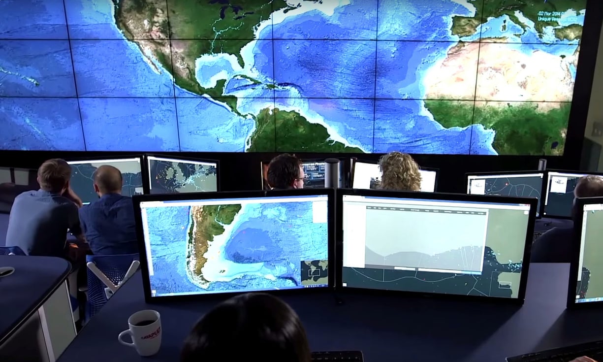
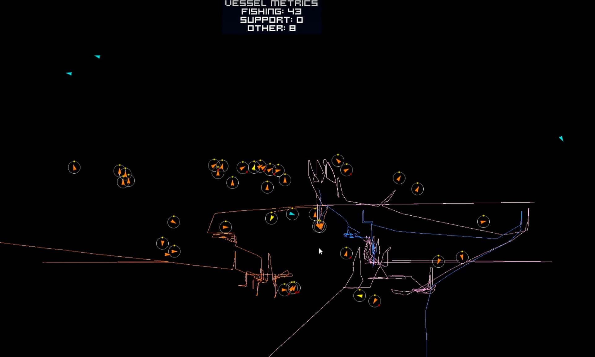
From their control centre in Oxfordshire, analysts from Satellite
Application Catapult can track vessels around the world and watch for
abnormal or illegal behaviour.
A new initiative is arming coastguards with satellite intelligence that
allows them to target their search for pirate fishing vessels in remote
marine areas
Despite a proliferation of huge, publicly lauded marine reserves,
actually stopping fishing in many remote areas has previously been
almost impossible. Fishing
vessels are required to carry a transponder that tracks their movements
and allows authorities to monitor their behaviour.
But illegal fishers
simply switch off the machine, disappearing from the system.
Take a deep dive into our groundbreaking satellite tool to combat pirate
fishing. Project Eyes on the Seas uses the latest technology to track
illegal fishing activity in real time, giving authorities the
information they need to protect the world's oceans.
A UK-funded initiative, developed by Satellite Applications Catapult (SAC) and the Pew Charitable Trusts, uses satellite radars
to track these “dark targets”.
Now, instead of blindly patrolling vast
areas of ocean, coastguard vessels use the satellite intelligence to
target their search.
“We don’t put a cop on every corner 24 hours a day. So let’s at least
know what the situation out on the water is [before sending boats to
investigate],” said Bradley Soule, senior fisheries analyst for SAC.
Satellite radar has traditionally been used by the military and law
enforcement agencies.
But the cost has dropped dramatically, opening up
the data for private companies to use.
“It is definitely a big deal,” he said. “[The global satellite
tracking] gives you a sense of the scope ... It is a wide-ranging
problem.”
Roughly one in every five fish landed around the world is
caught illegally.
In the past, said Soule, the problem was not effectively shared
between neighbouring governments. This meant “there are opportunities
for bad actors to move swiftly across borders and use our borders
against us”.
But even though the system is still effectively being trialled,
having only been in development for two years, it has already been used
during investigations.
The details of these are not yet public.
Soule said: “We have identified some abnormal behaviour and are working with the relevant authorities.”
Fishing vessels tracked using transponders.
Illegal vessels will often
switch off their transponders and “go dark”, making them impossible to
track without the use of satellite radar.
Photograph: Satellite
Applications Catapult
Just five years after the global figurehead of the International Union
for Conservation of Nature’s (IUCN) ocean protection programme, Dan
Laffoley, co-authored a report
that said that most marine protected area’s “are ineffective or only
partially effective” he now believes the reserves can now offer true
sanctuary.
“The excuses that it’s far too large, it’s far too remote, it’s far
too expensive are old excuses. The reality is that we do have the
technology to be able to police these places,” said Laffoley.
“There really is a breakthrough in terms of remote sensing,” said
Charles Clover, the chair of the Blue Marine Foundation who lobbied the
UK government for the creation of the Ascension marine protected area
(MPA).
However, he added that “the feasibility of actually taking a
prosecution through the courts using remote sensing [on its own] is
still questioned by the Foreign Office” and the technology would still
require boats in the water.
Ascension island in the GeoGarage platform (UKHO chart)
The Guardian understands that satellite technology will play a part in the enforcement of the 234,291km2
Ascension MPA.
An initial study of Ascension waters using satellites
found at least eight boats that had turned off their transponders and
were possibly fishing illegally.
SAC is already working with the UK government to track vessels in the world’s largest marine reserve around Pitcairn Island.
The announcement that the UK government
would ban fishing in more than half of the island’s huge territorial
waters (which are a British overseas dominion) was hailed as a “massive
step” by Laffoley.
Ascension’s lonely volcanic peak juts from the heart of the Atlantic
Ocean, almost midway between South America and Africa.
Laffoley said the
waters around Ascension were one of the few remaining places where the
marine environment had not been irreversibly damaged by overfishing.
But
even here, recent years have seen a rapid decline.
“There’s a fairly disastrous Asian longline fishery going off in
Ascension Island waters, which paid money into the Ascension Island
government to make up the shortfall [of funding] from London,” he said.
When he visited last year, Laffoley spoke with locals who told him
great natural events and creatures, such as “large tuna chasing fry up
the beaches that they’d seen generation after generation were becoming
more memories than reality”.
“When we were diving there we only saw one shark and there should have been plenty,” he said.
In 2015, a huge year for marine conservation, big reserves were designated in Palau, Easter Island, Pitcairn Island and New Zealand’s Kermadec islands.
The Ascension reserve brings the total proportion of the world’s oceans
protected from fishing to 2%. In 2002, the World Summit on Sustainable
Development and the Convention on Biological Diversity committed
countries to reaching 10% by 2012.
Almost half of Ascension’s waters will remain open to the (mostly
Taiwanese) tuna vessels that have caused so much damage in the past.
However, a $300,000 grant from the charitable foundation of US hedge
fund manager Louis Bacon will fund a policing presence for the next two
fishing seasons in order to “ensure best practice is observed”.
There is a good chance that one fish in five sold in a store or served in a restaurant has been caught illegally.
That would amount to 26m tonnes - the weight of nearly 500 Titanics - of fish a year.
The environmental cost of illegal fishing is huge: In the past fifty or so years one in four fisheries has collapsed, largely because of it.
And the economic cost is high too: 23 billion dollars according to the Pew Charitable Trusts.
But clever use of technology could help prevent this pillage.
How would it work?
A new satellite-based surveillance centre in Britain may be a game-changer.
Called a virtual watch room, it resembles the control centre for a space mission and can track fishing boats anywhere in the world with the results displayed on a giant video wall.
The watch room uses satellites to pull together data from multiple sources. including radar, photographic images and the signals emitted by radio transponders which are supposed to be fitted to fishing boats.
Automated alerts, such as when a vessel enters a prohibited area and slows to fishing speed, allow operators to zoom in on anything suspicious.
The watch room can also spot vessels working with another ship to which they transfer their catches for transport to market.
The virtual watch room has been developed by Pew Charitable Trusts and Satellite Applications Catapult.
But the success of the watch room’s technology will also depend on governments and the authorities responsible for fishing sharing information and enforcing international rules and regulations.
If, for example, radio transponders aren’t made mandatory on all fishing vessels, tracking them will be complicated.
Industry would also need to play its part by using the watch room’s technology to protect their supply chains.
The one-in-five illegal fish identified by Pew are often sold by otherwise law-abiding firms.
Now those firms have a way to reliably trace where their fish comes from.
If customers care enough about buying fish from sustainable sources, then retail pressure coupled with satellite technology should be a powerful weapon to combat pirate fishing.
But Laffoley said this left the job of protecting the area half done.
“I think we need to close that fishery still operating. After all, the
marlin, the turtles, the sharks and others won’t know which bit is open
and which bit is closed.”
“The reality is that if you want to have places in the ocean where
you’ve got the really impressive wildlife spectacles, where you’ve got
intact ecosystems, where you’ve got the big old individuals that we know
are more resilient and have better quality of eggs to reseed areas
[then you need no-take areas]. When you have a fishery, you lose them,”
he said.
Clover said the fishery was kept open by necessity in order to fund
the Ascension Island government.
UK government funding of public
services on the island is severely limited and the community has had to
open up licences to the fishing operators.
“It’s all about the [UK] Foreign Office not paying for this outfit,” said Clover.
Laffoley seconded Clover’s call for increasing the budget to make the
Ascension community viable without fishing.
“We have to question why we
are using the biodiversity and exploiting it, to then protect the
biodiversity,” he said.
“Is that a really good strategy when we are
seeing catastrophic declines where we’ve had fisheries?”
President Obama's Science and Technology Advisor, Dr. John Holdren,
explains the polar vortex in 2 minutes—and why climate change makes
extreme weather more likely going forward.
The polar vortex has strengthened this year, helping exacerbate current mild weather.
It has been ridiculously warm across the eastern half of the country
this month, with many spots likely to see their warmest December on
record. New York City may reach as high as 72°F on Christmas Eve.
Washington D.C. is forecast to reach the mid-70s, and Miami the mid-80s.
One of the factors behind this decidedly un-Christmas-like weather is a feature that came to be associated with the brutally cold winters of the past few years: the infamous polar vortex.
But if you like warm winter days, enjoy it while you can.
Because
while the current state of the polar vortex is keeping dreams of a White Christmas at
bay, a shift could soon be in the offing, one scientist says,
potentially ushering in a more typical winter wonderland in January.
Over the past two years, the term polar vortex became synonymous with the bitter outbreaks of Arctic air that sent teeth chattering from Boston to Atlanta (after all, polar is right there in the name).
The polar vortex is a feature of the atmosphere defined as the fast
moving current of air encircling the Arctic that forms during the cold
months because of the increased temperature difference between the dark,
frigid Arctic and the warm tropics.
There are actually two vortices,
one in the layer of the upper atmosphere known as the stratosphere and
one in the lower section, where our weather happens, called the
troposphere.
These two features interact with each other and can affect
the meteorological goings-on outside of the Arctic.
The polar vortex also interacts with other features and fluxes in the atmosphere, which causes it to vary in strength over time.
North pole could be 35C warmer than average this week, warn meteorologists
When the polar vortex is strong, as it is now, it keeps arctic air
fenced in.
That is part of what is currently keeping the weather so mild
in the eastern U.S..
But when the vortex is perturbed or weakened, the
jet of air becomes more wobbly and can set up southward excursions of
frigid air — what we saw plenty of times over the last couple winters.
The polar vortex is particularly susceptible to such weakening when it
reaches its peak in mid-winter, Judah Cohen, an atmospheric scientist
with the private firm Atmospheric and Environmental Research (AER), said
in an email.
And that is what Cohen is forecasting will take place in January.
Cohen expects some pulses of energy working their way from the lower
to upper atmosphere to perturb and weaken the polar vortex over the next
few weeks.
That weakening would favor a dip in temperatures over the
eastern U.S. and potentially an uptick in snowstorms, Cohen wrote in an AER blog post.
A
map showing the difference between temperatures on Dec. 30 and averages
shows how a potent storm carried extremely warm air over the North
Pole.
Some research suggests that the rapid warming of the Arctic,
which is happening at about twice the pace of the planet as a whole,
could be impacting the polar vortex.
Cohen and others think that declining sea ice and
increased snow cover in Siberia are two manifestations of this
amplification that are exerting a weakening influence on the polar
vortex, which could be fueling more outbreaks of Arctic air.
Cohen thinks that the pulses of energy he expects to perturb the
vortex over the next few weeks are related to particular areas of low
sea ice and high snow cover present this fall and winter.
But this research is hotly debated.
“There are many that argue that
any influence of Arctic amplification cannot be detected above the noise
of the intrinsic or natural variability of the atmosphere,” Cohen said.
If the Arctic chill from the weakening of the polar vortex blows in
next month, Cohen, a self-avowed fan of winter weather, would welcome
the switch.
At first he didn’t mind Boston having a break after last year’s epic snows, “but I have to admit I miss winter and this is just crazy,” he said.
Ben Harris is a traditional wooden boat builder based in Cornwall, UK. This
film documents Ben Harris’ love of wood work and boat building, how he
acquired his skills, and how incredible it is to be able to take
something that you’ve built with your own hands out onto the water and
sail it across the sea.
Who is Ben Harris?
Ben has always loved wood.
His mother said that his first word was ‘log’.
He has been working with wood throughout the UK since the age of 15.
First as an assistant to a cabinet maker, where he started by sharpening the tools and clearing up.
He then developed his skills in furniture making and his passion for wood and forestry by working in broadleaf woodlands.
Later he tuned his skills in bespoke oak-framed carpentry and went on to establish a sawmill and oak framing business in Scotland, sourcing timber from the local estates.
In 2005 Ben moved to Cornwall to study boatbuilding.


