Saturday, January 6, 2018

Slurpee waves return to Nantucket


Photographer Jonathan Nimerfroh captured the rare Slurpee Wave natural phenomena off Nantucket, MA once again at Nobadeer Beach on Jan. 2, 2018.

The natural phenomena that has hit the island of Nantucket the past few winters due to freezing cold temperatures has struck again.
That’s right, the Slurpee Wave is back in 2018 and photographer Jonathan Nimerfroh was there again to document the icy waves.

The air temperature was 12-degrees while the ocean was a balmy 36 on this particular day, which both lend themselves to some ice formation.
Keep in mind, this is the ocean, not fresh water like those photos you see from the Great Lakes with the crazy ice beards -- salt water freezes at a much lower temperature than fresh water.
“It’s not that bad once you get in there,” Jamie Briard said after getting out from the slushy waters.
“I’ve never done anything like that,” Nick Hayden says after getting out, icicles formed on both of them.
“I could see my fins slicing through the slush.”

Links :


Friday, January 5, 2018

Oceans suffocating as huge dead zones quadruple since 1950, scientists warn

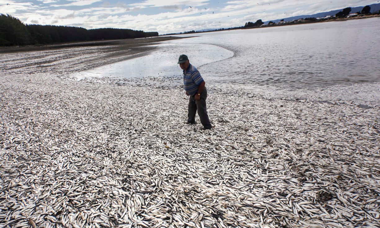
 A fisherman on a beach in Temuco, Chile that is blanketed with dead sardines, a result of algal blooms that suck oxygen out of the water.
Photograph: Felix Marquez/AP

From The Guardian by Damian Carrington

Areas starved of oxygen in open ocean and by coasts have soared in recent decades, risking dire consequences for marine life and humanity

Ocean dead zones with zero oxygen have quadrupled in size since 1950, scientists have warned, while the number of very low oxygen sites near coasts have multiplied tenfold.
Most sea creatures cannot survive in these zones and current trends would lead to mass extinction in the long run, risking dire consequences for the hundreds of millions of people who depend on the sea.

Climate change caused by fossil fuel burning is the cause of the large-scale deoxygenation, as warmer waters hold less oxygen.
The coastal dead zones result from fertiliser and sewage running off the land and into the seas.

The analysis, published in the journal Science, is the first comprehensive analysis of the areas and states: “Major extinction events in Earth’s history have been associated with warm climates and oxygen-deficient oceans.”
Denise Breitburg, at the Smithsonian Environmental Research Center in the US and who led the analysis, said: “Under the current trajectory that is where we would be headed. But the consequences to humans of staying on that trajectory are so dire that it is hard to imagine we would go quite that far down that path.”
“This is a problem we can solve,” Breitburg said. “Halting climate change requires a global effort, but even local actions can help with nutrient-driven oxygen decline.”
She pointed to recoveries in Chesapeake Bay in the US and the Thames river in the UK, where better farm and sewage practices led to dead zones disappearing.

However, Prof Robert Diaz at the Virginia Institute of Marine Science, who reviewed the new study, said: “Right now, the increasing expansion of coastal dead zones and decline in open ocean oxygen are not priority problems for governments around the world. Unfortunately, it will take severe and persistent mortality of fisheries for the seriousness of low oxygen to be realised.”

The oceans feed more than 500 million people, especially in poorer nations, and provide jobs for 350 million people.
But at least 500 dead zones have now been reported near coasts, up from fewer than 50 in 1950.
Lack of monitoring in many regions means the true number may be much higher.

The open ocean has natural low oxygen areas, usually off the west coast of continents due to the way the rotation of the Earth affects ocean currents.
But these dead zones have expanded dramatically, increasing by millions of square kilometres since 1950, roughly equivalent to the area of the European Union.


Low-oxygen zones are spreading around the globe.
Red dots mark places on the coast where oxygen has plummeted to 2 milligrams per liter or less, and blue areas mark zones with the same low-oxygen levels in the open ocean.
(GO2NE working group. Data from World Ocean Atlas 2013 and provided by R. J. Diaz)
Furthermore, the level of oxygen in all ocean waters is falling, with 2% – 77bn tonnes – being lost since 1950.
This can reduce growth, impair reproduction and increase disease, the scientists warn.
One irony is that warmer waters not only hold less oxygen but also mean marine organisms have to breathe faster, using up oxygen more quickly.

There are also dangerous feedback mechanisms.
Microbes that proliferate at very low oxygen levels produce lots of nitrous oxide, a greenhouse gas that is 300 times more potent than carbon dioxide.

Beautiful colours of an algae bloom off the coast of the Falklands towards the end of 2017
captured by OLCI on Sentinel-3

In coastal regions, fertiliser, manure and sewage pollution cause algal blooms and when the algae decompose oxygen is sucked out of the water.
However, in some places, the algae can lead to more food for fish and increase catches around the dead zones.
This may not be sustainable though, said Breitburg: “There is a lot of concern that we are really changing the way these systems function and that the overall resilience of these systems may be reduced.”

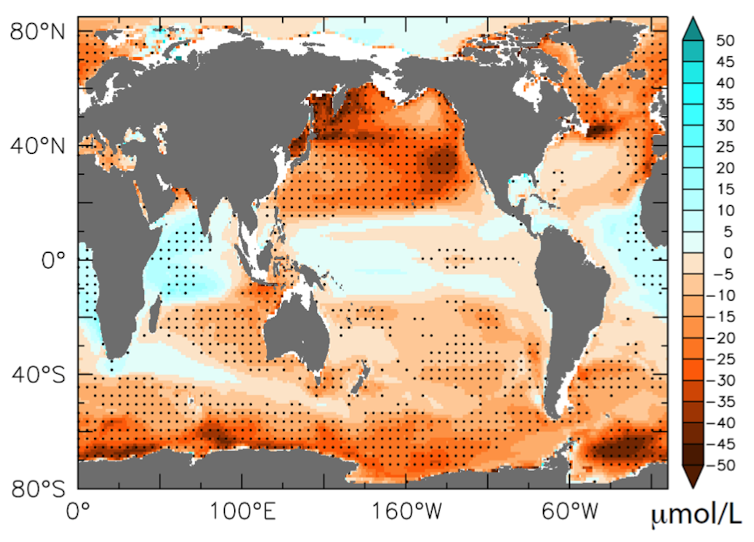
 Projected oxygen concentration changes at 200-600 meters’ depth in the oceans, comparing model projections for 2090-2099 to 1990-1999. Bopp, L., L. Resplandy, J.C. Orr, S.C. Doney, J.P. Dunne, M. Gehlen, P. Halloran, C. Heinze, T. Ilyina, R. Séférian, J. Tjiputra, and M. Vichi. 2013, CC BY

The new analysis was produced by an international working group created in 2016 by Unesco’s Intergovernmental Oceanographic Commission.
The commission’s Kirsten Isensee said: “Ocean deoxygenation is taking place all over the world as a result of the human footprint, therefore we also need to address it globally.”

Lucia von Reusner, campaign director of the campaign group, Mighty Earth, which recently exposed a link between the dead zone in the Gulf of Mexico and large scale meat production, said: “These dead zones will continue to expand unless the major meat companies that dominate our global agricultural system start cleaning up their supply chains to keep pollution out of our waters.”

Diaz said the speed of ocean suffocation already seen was breathtaking: “No other variable of such ecological importance to coastal ecosystems has changed so drastically in such a short period of time from human activities as dissolved oxygen.”
He said the need for urgent action is best summarised by the motto of the American Lung Association: “If you can’t breathe, nothing else matters.”

Links :

Thursday, January 4, 2018

Bombogenesis : why the bomb cyclone hitting the US East Coast is so unusual

24-hour OPC surface & wind/wave forecasts from today indicate intense low pressure to develop in the W Atlantic by 1200 UTC 01/04/18 (7 AM EST tomorrow morning) with winds up to 80 kt and seas to 33 ft!

From Wired by Megan Molteni

Now, the first thing you should know about a bomb cyclone is it’s just a name—and unlike a sharknado, it’s not a literal one.
The very real scientific term describes a storm that suddenly intensifies following a rapid drop in atmospheric pressure.
Bombing out, or “bombogenesis,” is when a cyclone’s central pressure drops 24 millibars or more in 24 hours, bringing furious winds that can quickly create blizzard conditions and coastal flooding.


It’s actually not that rare a phenomenon; meteorologists estimate these kinds of storms break out in the Northern Hemisphere about 10 times a year.
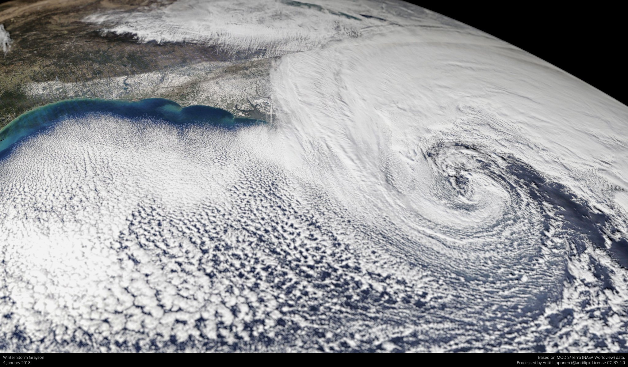
They can go by other names, like Nor’easter and mid-latitude cyclone, which may explain why you’ve never heard of one before Winter Storm Grayson started dumping snow in Tallahassee on Wednesday morning.
But Grayson isn’t your typical bombogenerator.

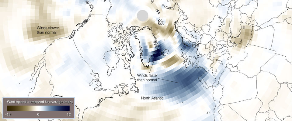
Fourteen of 20 hurricane-force wind events underwent bombogenesis in the North Atlantic during the first two months of 2014.
This unusual activity can be seen in wind speed data from the period.
In this image, blues indicate areas with wind speeds that are faster than the 30-year historical average (1981-2010).
Bombogenesis, a popular term used by meteorologists, occurs when a midlatitude cyclone rapidly intensifies, dropping at least 24 millibars over 24 hours.
A millibar measures atmospheric pressure.
This can happen when a cold air mass collides with a warm air mass, such as air over warm ocean waters.
The formation of this rapidly strengthening weather system is a process called bombogenesis, which creates what is known as a bomb cyclone.

It’s what happens when everything comes together just right (or just wrong).
Grayson is expected to explode up the East Coast between now and Friday, intensifying as it makes its way from Florida to Nova Scotia, blowing record snowfalls around at category 3 hurricane wind speeds.
“This storm is a synoptic meteorologist’s dream,” says Paul Huttner, who watches the weather for Minnesota Public Radio.
“It’s a perfect alignment of the three things we look for.”

The first is a warm conveyor belt of tropical moisture, which the Gulf Stream is shuttling out of the Caribbean and right up the Atlantic coast.
That’s pretty normal for this time of year.
What’s less normal is the huge subzero air mass that dipped down from the Arctic about 10 days ago, plunging the Great Lakes and Eastern US into a sustained deep freeze.

Every year, around this time, the sun stops shining above the Arctic circle.
No radiation means no heat, which means all that air gets real cold real quick.
Most of the time, jet streams—the easterly flowing air currents near the upper reaches of the atmosphere—keep that cold air bottled up in the Arctic.
But sometimes, upper air waves shift, forcing a buckle in the jet stream and allowing all that air to spill southward.

 source : NASA

“The coldest air on the planet just happened to slide over Northeast America,” says Huttner.
“And with this incredible moisture feed we’ve now got a huge temperature contrast.
By the time this thing gets up into New England we’re talking about a good 100 degrees of temperature contrast across the center of the storm.
And generally speaking, the stronger the temperature contrast, the deeper the storm.”

Differences in temperature, you see, lead to differences in pressure.
As the pressure drops, air rushes in.
The faster it drops, the faster the air moves.
And thus, a winter storm is born.

Unlike hurricanes, which slow down as they head north and get away from the moist heat of the ocean, bomb cyclones tend to reach their peak intensity when they hit New England.
That’s where the maximum temperature contrast usually is.
It’s also where the third thing meteorologists look for—a low pressure trough in the upper levels of the atmosphere—happens to be occurring right now.

NOAA scientists are estimating that Grayson will wind up dropping between 60 and 70 millibars over 48 hours, ending Thursday evening near Nova Scotia.
Not only would this be one of the most rapid rates of bombogenesis associated with an East Coast storm, but with its central pressure expected to bottom out near 950 millibars, it puts Grayson among the strongest offshore storms in recent history.
(For comparison, Nor’easters such as Nemo, Juno, and Stella didn’t dip below 970 mb.)

This is leading to faster and stronger winds than you’d typically see in a storm this time of year, says Gregg Galina, a meteorologist with NOAA’s Weather Prediction Center.
He’s been monitoring Grayson from the agency’s outpost in College Park, Maryland, which was just starting to get some snow and light winds by 9pm Eastern time Wednesday.
It’s the first winter storm to really test out NOAA’s new GOES-16—its most advanced weather satellite ever—which first locked into position over the US in December.

GOES-16 scans the Earth five times faster than previous sats, sending back images every 15 minutes.
That, along with new ozone-measuring capability, helps Galina forecast the storm’s impact.
The compound acts as a kind of tracer for low pressure pulling down on the stratosphere, and gives an idea about the vorticity—or the spin—of the atmosphere.
“It’s kind of like an ice skater spinning with her arms out,” says Galina.
“As she brings them closer to her body she spins faster.
It’s the same in a cyclone; the increased spin tightens the wind field.”

Galina and others on his team will be feeding satellite data into their models over the next few days to predict what Grayson has in store.
And they’ll also use data collected from inside the eye of the storm.
On Wednesday afternoon, a military air crew loaded up a WC-130J Super Hercules with about 30 dropsondes—parachute-equipped weather sensors—and took off from Keesler Air Force Base in Biloxi, Mississippi headed straight into the storm’s path.
Over the next 10 to 12 hours, they released the sensors into the frozen gale, and as they fell they sent back real-time readings on air pressure, temperature, humidity, wind direction, and speed.

All of this is necessary because there’s still a ton scientists don’t know about winter storms.
In particular, how much of a power boost they draw from rapidly-warming oceans.
“The global ocean is as warm now as it has ever been,” says Kevin Trenberth, a senior scientist at the National Center for Atmospheric Research.
“The main consequence of that is that winter storms can dump much bigger snowfalls if they combine with cold air, like the kind coming down on the Montreal Express right now.”

And at least according to some climate scientists, this pattern is likely to repeat itself even more in the future.
Rutgers climatologist Jennifer Francis is one of a growing number of researchers who believe that the warming Arctic will leave less of a temperature difference between the equators and poles, weakening the jet stream.
A weaker jet stream would allow cold air to push down, or warm air to wander north, more frequently, setting up more opportunities for a violent atmospheric showdown.
“We expect these patterns to become more frequent, but they may align differently in different years,” says Francis.

Others are less sure.
Kerry Emanuel, an atmospheric scientist at MIT, notes that as you go higher up into the atmosphere, the opposite trend is true: The tropics are warming faster than the poles, 10 miles up.
“Winter storms depend on both surface temperature and higher up in the atmosphere,” he says.
“The models are all over the place about whether these are going to get more or less intense.
Frankly, it’s an unsolved problem in the field.”

Researchers will have to wait until Grayson runs its course to know for sure whether it’s a record-breaking storm.
And a little bit longer to find out if “record-breaking” is just the new normal.

Links :
Wednesday, January 3, 2018

Bogoslof Island: a puzzle for geographers

Sentinel-2 animation from April 2016 to October 2017

From EarthStartsBeating

Bogoslov Island has a Russian sounding name and indeed belongs to the Aleutian Islands, Alaska which was sold by Russia to United States in 1867.

 Bogoslof island in the GeoGarage platform (NOAA charts)

It is actually the summit of a stratovolcano 1800 m height from the seabed and emerged from the ocean in late 1800 after an underwater eruption and since then has been continuously changing its aspect and contours after each volcanic activity.

Current status of Bogoslof Island as acquired by Sentinel-2 in October 2017, the volcanic activity is visible as mud water streams on the East side.
 
The Island visibly changed its shape after the eruption occurred in December 2016 and the geographic maps (including Google Maps) need to be systematically updated to reflect the actual morphology of the island.

 courtesy of USGS

In March 2017 Bogoslof was 0.98 km2 (in December 2016 was 0.3 km2) in size forming into a large circular island around the central vent, and seems to continue to grow.


Bogoslof island is also an important sanctuary for sea lions and nesting marine birds being a breeding site for seabirds and many species of seals.

The Ferdinandea Island guarded by a British ship in a old painting.

An analogous island appeared in similar circumstances between Sicily and Tunisia in summer 1831 after a submarine eruption and was called Isola Ferdinandea (Italian) or Graham Island.
The event caused an international dispute amongst France, UK and Kingdom of two Sicilies over its sovereignty due to its important strategic location in the middle of the Mediterranean Sea.
“Fortunately”Graham island disappeared beneath the waves again in early 1832 and since then still remains at 6 m under sea level.

Links :

Tuesday, January 2, 2018

Image of the week : Shark Bay, Australia

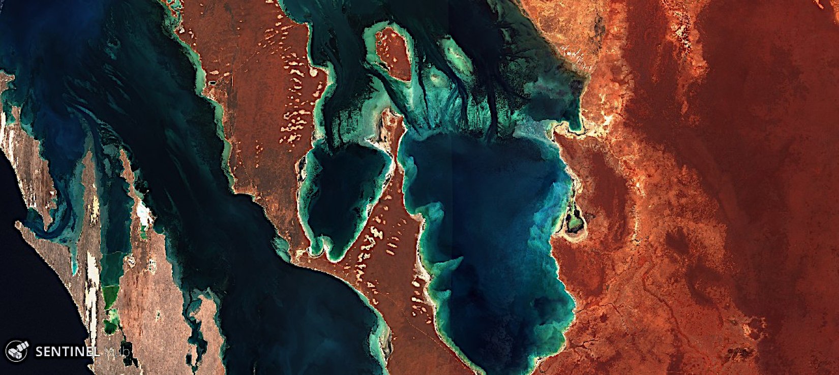
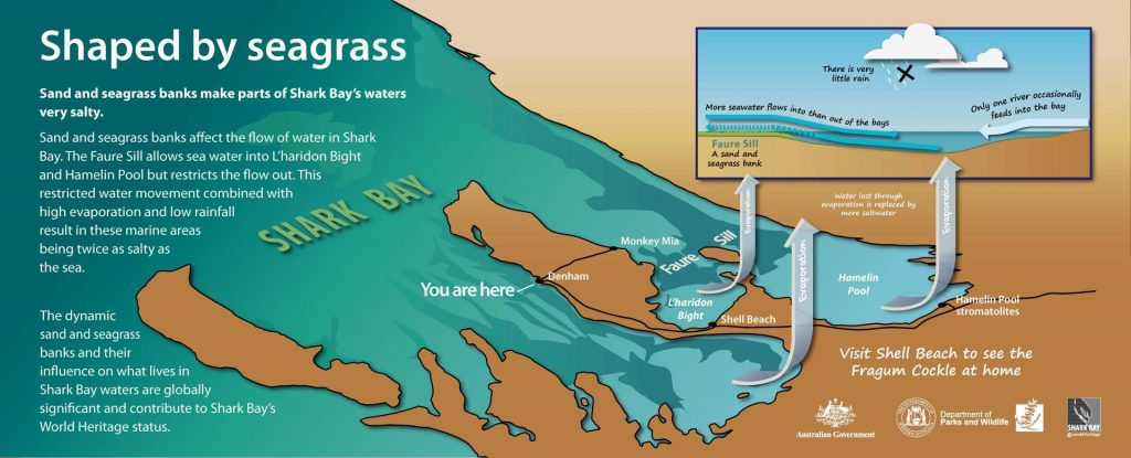
The vast, but fragile seagrass beds of Shark Bay World Heritage Area (Western Australia) [12/1/2017; Sentinel-2 satellite]

 The geological processes creating hypersaline waters and unique ecosystems they support are among the features that lead to Shark Bay’s World Heritage listing.
courtesy of sharkbay.org
 Shark Bay in the GeoGarage platform (AHS nautical chart)

Monday, January 1, 2018

Happy New Year 2018

  "The sea teaches sailors dreams that the ports are killing"   Bernard Giraudeau

In 2018, don't forget to escape for dream once in a while.
And thanks for following us during this new year. 

Sunday, December 31, 2017

Sea pilgrim

Sea Pilgrim from Will Mayer
Sea Pilgrim is a meditative film on Brazilian sailor Tassio Azambuja.
While sailing alone this past year, the silence I felt petrified me.
It opened up a great amount of insignificance in my own life.
As a response to this, I set out to create this film exploring silence in a day and age infiltrated with busyness.
We’ve become conditioned that the pursuit of fame and commercial success are the only ways we can be content.
My hope is simply to propose an alternative.
Living a life dedicated to the surrender of something greater than yourself.
Something unknown.