Saturday, July 30, 2022

Mysterious seafloor holes stump ocean scientists


NOAA's ocean explorers spotted these regular, perforation-like holes in the seafloor.
NOAA


From CNET by Amanda Kooser

Sea monster? Aliens? Humans? Give it your best guess.

Talk about the mysteries of the deep.
The crew of the National Oceanic and Atmospheric Administration's Okeanos Explorer vessel caught sight of some weird hole formations on the Atlantic seafloor over the weekend.
 
What caused them?
Even NOAA's scientists aren't sure.

Okeanos Explorer is investigating the Mid-Atlantic Ridge, a largely unexplored area of seafloor that's home to a massive underwater mountain range.
The team is mapping the ocean bottom and studying coral and sponge communities.
NOAA often livestreams the ship's remote-operated vehicle dives.

"On Saturday's Okeanos dive, we saw several sublinear sets of holes in the seafloor.
The origin of the holes has scientists stumped," the NOAA ocean team tweeted on Monday.
"The holes look human made, but the little piles of sediment around them suggest they were excavated by...something."
NOAA asked for Twitter users to chime in with their own ideas to explain the holes.
 

NOAA said similar holes had been reported in the region before.
Twitter users naturally had some thoughts on the matter, suggesting the perforation-like holes could be from fishing gear, a hidden crack in the seafloor or a piece of buried pipe.
On the animal-related front, some suggested a burrowing or swimming critter might have left the small marks.

Here's a closer look at some of the indentations, which seem to be almost rectangular.


Here's a closer look at those mysterious seafloor holes.NOAA

There were some more fanciful responses, like "a really big graham cracker" and "ants." One person joked it might be aliens.

The intrigue is reminiscent of when a different exploration vessel spotted a "yellow brick road" formation on the seafloor of the Pacific earlier this year.
That one had a good explanation connected to volcanic action.

The Atlantic holes will remain an enigma for now, but maybe it's time for an underwater X-Files division.
A deep-sea Scully should be able to sort this out.
 
Links :

Friday, July 29, 2022

How a satellite found a tiny island—and made Canada a bit bigger

Landsat 1, launched in July 1972, was the first satellite designed to study Earth from orbit.
The spacecraft is seen here in flight configuration with its solar panels deployed at the former GE plant in Valley Forge, Pennsylvania.

From National GeoGraphic by Nadia Drake
 
Discovered only about 50 years ago, Landsat Island off the country's Atlantic coast bears the name of the world's first Earth-observing satellite program.

Squint closely at a map of the North Atlantic, off the eastern coast of Canada’s Newfoundland and Labrador Province, and you’ll see … well, nothing.
The uninhabited island that should be there is too tiny for even Google Maps to display.

not viewable on Google Maps or Google imagery
but viewable with the GeoGarage platform with CHS nautical raster chart
In 1976, a Canadian coastal survey was carried out using data from the Landsat 1 satellite.
Analysis of the data revealed several previously uncharted features; this includes Landsat Island, which was subsequently named after the satellite.
Verification of the island's existence fell to Dr. Frank Hall of the Canadian Hydrographic Service:
[Dr. Hall] was strapped into a harness and lowered from a helicopter down to the island.
This was quite a frozen island and it was completely covered with ice.
As he was lowered out of the helicopter, a polar bear took a swat at him.
The bear was on the highest point on the island and it was hard for him to see because it was white. Hall yanked at the cable and got himself hauled up.
He said he very nearly became the first person to end his life on Landsat Island.
— From Scott Reid's account of Dr. Hall's Landsat Island expedition given to the Canadian Parliament on October 30, 2001.
Following Dr. Hall's encounter with the polar bear, it was suggested that the island be named "Polar Island,"but the present name was retained.
Landsat Island marks the easternmost point of the Canadian land mass along this section of the Labrador coast.
As such, its discovery increased Canada's maritime territory by 68 square kilometres (26 sq mi). 
 
or with CA476682
ENC from CHS
 

But nearly 50 years ago NASA’s first Earth-observing satellite, a joint project with the U.S. Geological Survey, picked up the island’s spectral signature from more than 500 miles high. The discovery increased Canada’s territorial area by 26.25 square miles—a modest expansion that nonetheless heralded an exciting accomplishment for the program today known as Landsat.
In 1979 the outcrop was officially named Landsat Island, after the revolutionary eye-in-the-sky that had spotted it.

“It just totally changed the field of cartography,” Terry Sohl, a researcher with the USGS Earth Resources Observation and Science Centre, says of the program.

NASA might be better known for looking up at the stars, but the space agency’s satellites have also been staring down at our home world for half a century.

Inspired by the space-based imagery of Earth returned during the Mercury and Gemini flights, the Earth Resources Technology Satellite took flight on July 23, 1972.

A few years later, it would become known as Landsat 1. Still managed by NASA and the USGS, the Landsat program has become the longest-running Earth-observation enterprise in history.


Landsat Island, as photographed from a Canadian Coast Guard helicopter in 1997.
Photograph by David Gray


“If you think back to the mid-60s, the space race was going on, the U.S. public was enamoured with what was happening, and it was a unique idea to use that technology not only for military applications but to turn those cameras around and look at what’s happening on the Earth’s surface,” Sohl says. “People really didn’t know what to expect.”

Since 1972, nine Landsat satellites have populated Earth’s skies (although one—Landsat 6—didn’t reach orbit).
Today three of them loop around the planet in polar orbits, staring at 115-mile-wide swaths of land and making highly detailed measurements.
Every 16 days the same spots get another look by the same satellites.
So over five decades of Earth-gazing, Landsat has compiled the most detailed record ever of our planet’s changing face.

“It has been a great program of discovery,” says NASA’s James Irons, who’s been a leader of the Landsat program for decades.
“At the time of the Landsat 1 launch, not all of Earth was well mapped—the data were quite thin.”

And that set the stage for cartographer and pilot Elizabeth Fleming to use Landsat data to make an unusual mark on history.

The pixel that expanded Canada


In 1973 a Canadian coastal survey decided to use Landsat data to better map the country’s sparsely charted northern coasts.
While inspecting the satellite’s data, Fleming spotted a telltale signature in the spectrum of light bouncing off Earth’s surface.
She concluded that it came from an island, not an iceberg.

Measuring just 82 feet wide by 148 feet long, the rocky atoll reflected infrared light rather than absorbing it like the surrounding seawater.
The island was too tiny to be properly resolved, but it significantly altered the average reflectance of the pixel it occupied.

“For that one pixel, it’s a mix of water and a mix of land,” Sohl explains.
“So you see a sharp contrast with the surrounding area.”

In 1976 a team from the Canadian Hydrographic Service took to the skies above Northern Labrador to verify the island’s existence and fix its position on the map; after all, it had only been seen in one pixel of satellite data.
About 12 miles offshore, the desolate hunk of rock protruded from the froth in an area known as the fringe—a treacherous assemblage of reefs, shoals, and undersea rocks that mariners avoid. Fleming’s discovery held: The island existed.

As recounted to the Canadian Parliament, when hydrographer Frank Hall was lowered from a helicopter to the ice-covered island, he narrowly escaped a lethal swat from an obscured polar bear.

“I can still remember listening to the radio as a small boy and hearing with some excitement, because I had dreams of being an explorer when I grew up, of the discovery of the new island off Canada's east coast,” Scott Reid, a member of Parliament, said in 2001.
“It was a discovery of practical importance to Canada because it allowed Canada to expand its territorial waters.”

The Landsat legacy

The newest members of the Landsat fleet—Landsat 9 launched in September 2021—are more advanced iterations of Landsat 1.
They study our planet in more wavelengths of light, their eyes are sharper, and they have thermal imagers aboard.

From their perches in orbit, these satellites measure receding coastlines, characterise urban heat islands, surveil an Amazon gold rush, and even track the amount of water consumed over 20,000 acres of California wine country.

“The applications for remote sensing, whether it’s vineyards or agriculture, or helping people fight fires in the West—it is just cool to be involved,” Sohl says.

Today Landsat is joined by hundreds of Earth-observing satellites, both government and commercial. This constellation makes crucial observations that help guide decisions about managing our planet’s increasingly strained resources.

“In all of our Earth observations, we are observing the impacts of a growing population,” Irons says. When Landsat 1 launched, fewer than four billion humans lived on planet Earth, a number that has since doubled.
“It becomes increasingly difficult for the resources of the Earth to sustain us under those conditions,” he says. 
“But I try to be optimistic, and my hope is that given accurate information, that people will be better positioned to make wise decisions.”
 
Links :

Wednesday, July 27, 2022

Mass mortality events linked to marine heatwaves could become the new norm in the Mediterranean Sea

MHWs, marine heatwaves : SST anomalies in Mediterranean Sea
 
From Phys by ICM-CSIC

Mass mortality events linked to marine heatwaves could become the new norm in the Mediterranean Sea

Marine heatwaves drive recurrent mass mortalities in the Mediterranean Sea.
Credit: Garrabou et al 2022
 
An international team of researchers led by the Institut de Ciències del Mar (ICM-CSIC) has proven that, between 2015 and 2019, the Mediterranean experienced a series of marine heat waves that affected all regions of the basin, which resulted in recurrent mass mortality events throughout the period analyzed.
The details are reported in a study recently published in the journal Global Change Biology.

According to the work, that has also involved experts from the Centre d'Estudis Avançat de Blanes (CEAB), the Institut Mediterrani d'Estudis Avançats (IMEDEA), the Instituto Español de Oceanografía (IEO), the Universitat de Barcelona (UB), the Universidad de Alicante (UA), the Universidad de Sevilla (US) and the Museo del Mar de Ceuta, as well as other international centers, populations of some 50 species (including corals, sponges and macroalgae, among others) were affected by these events along thousands of kilometers of Mediterranean coasts, from the Alboran Sea to the Near Eastern coasts.

"Specifically, the impacts of mortalities were observed between the surface and 45 meters' depth, where the recorded marine heat waves were exceptional, affecting more than 90% of the Mediterranean surface and reaching temperatures of more than 26ºC," explains the ICM-CSIC researcher Joaquim Garrabou, one of the authors of the study.


Key species, the most affected

Some of the most affected species are key to maintaining the functioning and biodiversity of the main coastal habitats.
These include Posidonia oceanica meadows or coral assemblages, two of the most emblematic habitats in the Mediterranean.

This is the first study to assess the effects of mass mortalities on a Mediterranean scale over five consecutive years.
In total, more than 30 research groups from 11 countries have participated, which has made it possible to note the incidence and severity of mortality in every corner of the basin.
In fact, this is the most complete picture yet of the impacts of extreme warming events on marine organisms and ecosystems in the Mediterranean.

"Unfortunately, the results of the work show that the Mediterranean Sea is experiencing an acceleration of ecological impacts associated with climate change, posing an unprecedented threat to the health and functioning of its ecosystems," regret Cristina Linares and Bernat Hereu, from the Faculty of Biology and the Biodiversity Research Institute (IRBio) of the UB.

From the exception to the norm

The climate crisis is severely affecting marine ecosystems around the world and the Mediterranean is no exception.
Specifically, the associated marine heat waves are causing massive mortality events in all coastal ecosystems of this basin as a result of their increased frequency, intensity and extent.

"Given this scenario, it is essential to know the relationship between the different biological responses of marine biodiversity and different levels of heat exposure," points out the US professor Free Espinosa. For their part, David Díaz and Emma Cebrián, researchers at the IEO and the CEAB, respectively, explain that "the high variability of observed responses among species and populations at very different spatial and temporal scales has undermined our ability to explore this relationship."

Now, thanks to the temporal and spatial resolution addressed, it has been possible to demonstrate that there is a significant positive relationship between the duration of heat waves and the incidence of mortality events.

"Mass mortality events in the Mediterranean are equivalent to the bleaching events also observed consecutively in the Great Barrier Reef, suggesting that these episodes are already the norm rather than the exception," highlights the UA professor Alfonso Ramos.

For all these reasons, the authors urge to strengthen coordination and cooperation at regional, national and international levels, as has been done in this work, in order to reach more effective management decisions to cope with the ongoing climate emergency.


Links :

It’s a Race Against Heat, and Humanity Is Losing

Plastic in the depths: how pollution took over our oceans

Plastic pollution in the Red Sea, Egypt, 23 Jun 2022.
Photograph: Andrey Nekrasov/ZUMA Press Wire/REX/Shutterstock

From The Guardian by Chris Michael

So much plastic pours into the sea every year that species are now endemic to it.
A new Guardian series looks at where it comes from, the harm it does and what can be done about it


By now, it is well known that the oceans swirl with plastic.
More than 8m tonnes pour into the seas every year, spewed out via rivers, dumped along coastlines or abandoned by fishing vessels.
Plastic even contaminates ocean air, where particles are kicked up by spray and then blown about the planet by the wind.
In many places on Earth, it is literally raining – and snowing – plastic.

While most images of ocean pollution show plastic bottles bobbing on the surface or straws being yanked from turtles’ noses, these are misleading: bottles and straws make up only a fraction of the total.

That is why, in the coming months, the Guardian’s Seascape project will take a microscope to the ocean to find out exactly what is in this plastic avalanche, where it comes from, what harm it is doing – to marine life and to us – and what can still be done about it.

The type of plastic that proliferates through the different levels of the ocean ecosystem depends in large part on where you look.
While bags and food wrappings dominate the shoreline, further out to sea it is abandoned fishing gear and plastic lids that choke the deeper waters.


Some of the sources of plastic are surprising, too: cigarette butts – yes, the filters are made largely of plastic – or sachets, those little packets for individual servings of ketchup or soap.
Sachets, as Seascape reporter Karen McVeigh has exposed, are a huge pollution problem, particularly in Asia where they were presented by companies such as Unilever as a convenient way to dispense affordable products for those on low incomes.
They have proved to be an intractable pollutant – tiny, difficult to collect and all but worthless to recycle.

Then there’s the vast, unseen churn of microplastics – trillions of tiny fibres, beads and shards.
Plastic is now so fully integrated into the Earth’s water system that every week most people drink a credit card’s worth of it.

Microplastic itself has many sources.
It comes from clothes fibres, swirling into the drain from washing machines.
It comes from nurdles, the “Lego blocks” for bigger plastics that are frequently spilled accidentally in their billions from container ships, causing as much damage as oil spills (though still not yet classified as hazardous).

And it comes, in huge quantities (representing more than a quarter of all microplastic in the ocean), from tyre dust, the residue generated from synthetic rubbers, fillers and softeners as people drive their cars (or , to a lesser but still notable degree, bicycles) down the street.

 
Lest we get too bogged down, we will also look at what can be done about all this plastic – how to clean it up, how to stop it getting there in the first place, and what you can do to help.

There’s now so much plastic in the ocean that scientists are treating it as a new biome: the plastisphere.
The species that live there are now endemic to it.
Plastic is their forever home, but it doesn’t need to be ours.
 
Links :

Tuesday, July 26, 2022

UKHO announces intention to withdraw from paper chart production

UKHO sets out transition plan for fully digital chart portfolio by end of 2026

UKHO sets out transition plan for fully digital chart portfolio by end of 2026 

The UK Hydrographic Office (UKHO) has announced its intention to develop options for the withdrawal from global paper chart production by late 2026 to increase focus on its digital navigation products and services.

Plans to withdraw the UKHO’s portfolio of ADMIRALTY Standard Nautical Charts (SNCs) and Thematic Charts are in response to more marine, naval and leisure users primarily using digital products and services for navigation.
The ADMIRALTY Maritime Data Solutions digital navigation portfolio can be updated in near real-time, greatly enhancing safety of life at sea (SOLAS).

The phased withdrawal of paper charts from production will take place over a number of years and is anticipated to conclude in late 2026.
In parallel, we will develop viable, official digital alternatives for sectors still using paper chart products.
This will be a carefully managed process, conducted in close liaison with all customers and stakeholders, including the Maritime and Coastguard Agency (MCA) as well as other regulatory bodies, hydrographic offices, industry partners and distributors.

Peter Sparkes, Chief Executive of the UKHO, said:
“The decision to commence the process of withdrawing from paper chart production will allow us to increase our focus on advanced digital services that meet the needs of today’s seafarers. As we look to the future, our core purpose remains the safety of shipping operations and delivering the best possible navigation solutions to achieve that. Whether for the Royal Navy, commercial vessels or other ocean users, our focus is on developing and delivering ADMIRALTY digital services that promote safe, secure and thriving oceans.
“We understand the significance of this announcement, given the distinguished history of the UKHO’s paper chart production and the trust that mariners have placed in ADMIRALTY charts over the generations. We will support users of SNCs during the withdrawal of our paper chart portfolio and work with our distributors to help users switch to digital alternatives between now and our planned date of 2026.”

The move to digital navigation solutions has been accompanied by a rapid decline in demand for paper charts, driven by the SOLAS-mandated transition to ECDIS and the wider benefits of digital solutions, including the next generation of navigation services, Peter Sparkes explained.
“Shipping is moving quickly towards a future underpinned by digital innovations, enhanced satellite connectivity at sea and optimised data solutions, supporting the next generation of navigation. The UKHO aims to be at the vanguard of this digital transition, continuing to provide the assured and globally trusted ADMIRALTY navigation services that seafarers the world over depend on.”

Baroness Goldie, Minister of State at the UK government’s Ministry of Defence, said:
“The world has changed unrecognisably in recent years, driven by digitalisation and rapid technological advancement. When it comes to maritime, one of our priorities at the Ministry of Defence is to make shipping as safe as possible; to achieve this, the industry must continue transitioning to digital tools and technology that share data almost instantly from ship-to-ship or ship-to-shore.
“As one of the world’s leading authorities on navigational charts, the UKHO is well positioned to recognise the need to deliver a range of digital solutions that enhance safety and data accuracy. The decision to focus on digital products and services makes strategic and commercial sense, helping usher in a new era of maritime navigation, which will be powered by digital innovations.”

Richard Bell, Assistant Director for UK Technical Services Navigation at the MCA, said:
“The MCA recognises the benefits of official digital navigation products for safe navigation, at a time when paper products make up a minority of navigation products being used at sea. This announcement by UKHO represents a clear vision for the future of navigation, which will need to be supported by official equipment and data suited to the needs of the different maritime end users.

“We are committed to working closely with the UKHO, stakeholders and industry to make this vision a reality. Close liaison will be essential, to ensure that the technical and legislative barriers to the proposed change are overcome in advance of the UKHO’s 2026 timeline.”

More information on UKHO’s carefully managed approach for the phased withdrawal of paper chart production can be found on the ADMIRALTY website.
 
in 1856, this @ADMIRALTYOnline chart of the River Thames was published, showing London to Gravesend.

Modern paper charts in the GeoGarage platform (UKHO raster paper chart)

 Links :

British Isles & misc. (UKHO) layer update in the GeoGarage platform

Ocean discoveries are revising long-held truths about life

The Orpheus from the Woods Hole Oceanographic Institution is designed to maneuver autonomously and in swarms of vehicles at the deepest depths and to land to collect samples on the fly.
Credit: Evan Kovacs/© Woods Hole Oceanographic Institution


From Scientific American by Timothy Shank


New findings show that the ocean is much more intertwined with our lives than we ever imagined

For more than 50 years deep-sea exploration has been a continuous fount of discoveries that change how we think about life in the ocean, on dry land and even beyond our planet.
Consider the following three events.

On October 16, 1968, a cable tethering the submersible Alvin to a research ship located 100 miles off Nantucket broke.
The sub sank to the seafloor more than 5,000 feet below; the crew of three escaped safely.
Nearly a year later, when a team brought Alvin back to the surface, the biggest surprise was that the crew's lunch—bologna sandwiches and apples in a plastic box—was strikingly well preserved.
Bacteriological and biochemical assays proved it.
Someone even took a bite.
Subsequent experiments in the Woods Hole Oceanographic Institution laboratory where I'm writing this article found that rates of microbial degradation in the retrieved samples were 10 to 100 times slower than expected.
This discovery, and others, led to the conclusion that metabolic and growth rates among deep-sea organisms were much slower than those of comparable species at the ocean's surface.

In 1977 scientists diving in the restored Alvin made another historic discovery—the first in-person observations of life around hot, hydrothermal vents rising from the seafloor.
This sighting overturned the long-held view that our entire planetary food web was built on photosynthesis—using sunlight's energy to convert carbon dioxide and water into complex carbohydrates and oxygen.
The hydrothermal organisms, and the entire ecosystem, thrived in pure darkness, converting chemicals in the vent fluid into life-sustaining compounds through a process we now call chemosynthesis.

If that revelation wasn't surprising enough, an expedition I was part of in 1993 exposed an earlier mistaken belief.
We had discovered a significant hydrothermal vent ecosystem on the East Pacific Rise.
The system had been destroyed by a seafloor eruption just a few years earlier, yet it had already been bountifully recolonized.
A bologna sandwich might decay so slowly in the deep that you could eat it a year later, but it turned out that biological processes in the deep sea could be extremely fast as well.

Each new ocean discovery that disrupts old dogma reinforces a much larger truth: the ocean is far more complex—and much more intertwined with our own lives—than we ever imagined.
For much of the 20th century, for example, scientists maintained that the deep ocean was a harsh, monotonous place of perpetual darkness, frigid temperatures, limited food and extreme pressure—conditions that should make complex forms of life impossible.
But new tools for observing, sensing and sampling the deep ocean, such as increasingly sophisticated underwater vehicles with high-definition camera systems, have demonstrated that biodiversity in the darkest depths may rival that of rain forests and tropical coral reefs.
These missions have further revealed that the depths are far from uniform; like kangaroo habitat in Australia and tiger lands in Asia, they are home to evolutionarily distinct biogeographic regions.

We are beginning to appreciate how connected these realms are to our own.
The rapid three-dimensional change of conditions such as temperature, salinity and oxygen concentration in the deep ocean and the currents and eddies that establish the boundaries of these provinces are expected to fundamentally change as the effects of human activity reach ever farther below the surface.
Already lobsters are moving to deeper, colder waters and molting at different times of the year.
Commercially important groundfish such as cod and haddock are migrating poleward in search of more suitable habitat.

We are seeing that the ocean's biogeographic boundaries are neither immutable nor beyond the imprint of humans.
In studies, more than half of sampled hadal organisms—those living in the deepest parts of the ocean, beyond 20,000 feet—had plastics in their gut.
PCBs, which were banned in the U.S. in 1979 and phased out internationally as part of the Stockholm Convention beginning in 2001, are also common in tissues of animals from the extreme bottoms of the sea.

We are also starting to learn that life in the deep might have things to teach us.
Deep-sea fish produce biomolecules called osmolytes that permit cellular functions, such as the precise folding and unfolding of proteins, to proceed unimpeded by crushing water-column pressures exceeding 15,000 pounds per square inch.
Medical researchers have determined that some of these molecules could help treat Alzheimer's disease, which is characterized by misfolded proteins.
In addition, decoding the genes that govern traits we see in deep-sea animals, such as those that stave off errors in DNA replication, transcription and translation, might be used in therapies for cancer and other afflictions.

The greatest paradigm that ocean exploration may tear down is that Earth represents the sole example of life in the universe.
Life might have existed on Mars when it hosted liquid water, and the fact that Earth and Mars have shared ejected material in the past means we could have exchanged the building blocks of life.
But the discovery of chemosynthetic life on Earth and the more recent finding of perhaps 13 liquid-water oceans underneath the icy shells of moons such as Jupiter's Europa and Saturn's Enceladus—places that may have been too distant to have shared life-bearing material with Earth in the past—raise the possibility of a second, independent genesis of life.
And if life can form twice in one solar system, then it could be anywhere we look in the heavens.

Monday, July 25, 2022

Why China’s challenges to Australian ships in the South and East China Seas are likely to continue


From The Conversation by Adam Lockyer
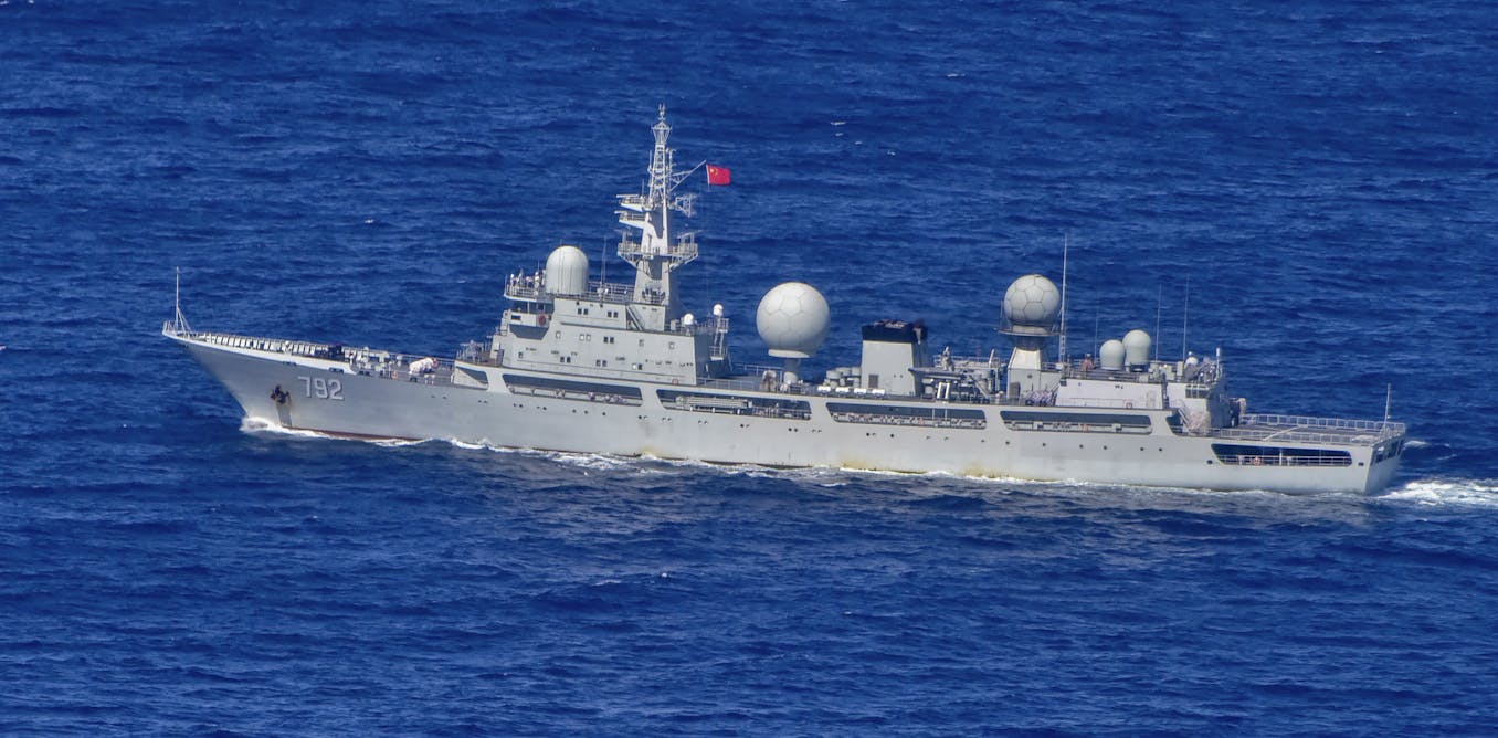
Last week it was reported an Australian warship had, in early July, been closely followed by a Chinese guided-missile destroyer, a nuclear-powered attack submarine, and multiple military aircraft as it travelled through the East China Sea.

This incident followed a confrontation on May 26, when an Australian maritime surveillance plane was dangerously intercepted by a Chinese fighter over the South China Sea.

Reportedly, the Chinese fighter flew treacherously close to the Australian plane, releasing flares, before cutting across its path and dropping chaff (a cloud of aluminium fibre used as a decoy against radar).

While there are good reasons not to exaggerate these events, the bad news is these incidents are almost certain to continue.
When they do occur, it’s important to place them within their broader historical and geopolitical context and not sensationalise them – we must not frame them as if we’re on the brink of war.

The good news: 3 reasons not to panic
There are three reasons why the significance of these events shouldn’t be exaggerated.

First, Asia’s seas are among the world’s busiest.
The warships of different navies are constantly operating in close proximity with each other and most of these interactions are professional and even courteous.
This includes most encounters with the Chinese navy.

A second, and related, point is that both the Chinese and Australian navies have grown significantly in size over the past decade.
More ships means more total days at sea, which means more opportunities for the navies to come into contact.

Most of these encounters are innocuous.
In our research on Australia’s naval diplomacy, for instance, the team at Macquarie University investigated reports a Chinese ship had spied on HMAS Adelaide visiting Fiji.

The reality, however, was the Chinese ship was deployed semi-permanently to the South Pacific as a satellite relay and regularly came in-and-out of Suva (Fiji’s capital) for supplies.
It was nothing more than a chance run-in.

Third, although confrontations aren’t common, they are also far from unprecedented.
During the Cold War, the warships of the United States and the Soviet Union frequently sparred.
Few forward deployments occurred without some contact with the opposing forces that may have included overflights, shadowing or dangerous manoeuvring.

Indeed, potentially dangerous interactions were common enough that in 1972 the Americans and Soviets signed the Incidents at Sea (INCSEA) agreement.
The agreement spelt out the “rules of the road”.
The superpowers also committed to an annual meeting between their senior naval officers, with the hosting responsibility alternating between them.

The agreement didn’t eliminate incidents at sea, but it did create a mechanism for the two parties to vent their frustrations, voice their protests and work constructively on solutions.
As the meetings were between the two nations’ top professional naval officers, there was a high degree of mutual respect and a genuine attempt to make the seas a safer place for their sailors.

The bad news: these incidents will continue

The US attempted to replicate their Soviet agreement with China. In 1998, the US and China agreed to the Military Maritime Consultative Agreement, which copied many of the successful parts of the Soviet agreement, including the annual meeting between their admirals to discuss concerning incidents.

The challenge, however, is that the geopolitical backdrop to the US-China agreement is significantly different from its Cold War antecedent.
During the Cold War, tensions at sea rose and fell just as they did on land.
However, the areas where the Soviet Union attempted to assert its claims (such as the Sea of Okhotsk and the Barents Sea) were isolated and icy and generally unimportant to everyone except the Soviets.
The Americans would prod there occasionally on intelligence gathering, freedom of navigation operations, or simply to rile up their rivals – but on the whole both sides understood the game.

In contrast, China has claimed exclusive coastal territorial sovereignty over the majority of the South China Sea, the Taiwan Strait and large parts of the East China Sea.
These are among the most geopolitically important and busiest waterways in the world.

Beijing’s options for convincing regional states to recognise its claims are limited, especially when foreign navies continue to traverse these waters, dismissively ignoring China’s sovereignty declarations.
 
Beijing has few options

Politically, China could attempt to horse trade, such as we’ll treat you as the custodians of the South Pacific if you accept our claims to the South China Sea.
Or use economic and diplomatic coercion.

In Australia’s case, neither of these strategies are likely to be successful as they would undermine our relationship with the US, and there’s the fear China will renege in the future.

This leaves tactical deterrence.
Describing how deterrence works, American economist Thomas Schelling used the analogy of two people in a row boat where one starts “rocking the boat” dangerously, threatening to tip it over unless the other one does all the rowing.
The threat is shared equally between them, but the boat rocker is counting on the other to back down because their appetite for risk is lower.

Confrontations in the air and sea are risky for both the perpetrator and the target.
On 1 April 2001, for instance, a Chinese fighter collided with an American signals intelligence aircraft.
The American plane was forced to make an emergency landing on Hainan Island, while the Chinese plane crashed and the pilot died.

What China is counting on is Australia not being as risk tolerant as they are.
They hope Australia will blink first.
But, Australia has shown no indication it will stop deploying to the region. Indeed, the aircraft that was threatened and damaged by chaff on May 26 was one of two Australian aircraft flying out of the Philippines at the time.
The Australians were not deterred and the second aircraft appears to have flown missions on May 27, May 30 and June 2 through the same airspace as the incident occurred.

As China and Australia have few other options than to continue doing what they’re doing, these incidents look likely to continue.

When they occur, however, it’s important they’re not taken out of their historical and operational contexts. 
 
Links :

Sunday, July 24, 2022

Australia (AHS) layer update in the GeoGarage platform

20 nautical raster charts updated
 
Terra Incognita in 1838 by Capt. Vetch
source : Stanford
 

Vision

'Le Souffle du Nord' IMOCA 60' , Thomas Ruyant onboard