Saturday, March 2, 2013

Man on the river

River water : London to Istanbul

5.200 kms on a rowing and sailing boat from London to Istanbul
(Google Maps) : 13 months of navigation

This is the journey of Giacomo De Stefano, 47 years old.
No engine : only wind and human force.
Why?
To rediscover the importance of river waters and to show the beauty of slow traveling, respecting nature.

Friday, March 1, 2013

250 m deep canyon found under Red Sea

A 3D image of the Grand Canyon-style ocean floor beneath the Red Sea

From Gov.uk

A Royal Navy survey ship has discovered a previously uncharted 250-metre-deep canyon on the floor of the Red Sea.

HMS Enterprise has produced a series of stunning images of a Grand Canyon-style ocean floor hidden deep under the Red Sea.

The vessel used her state-of-the-art surveying equipment to reveal the natural wonder during her nine-month mission to improve understanding of the waters east of Suez.


Discovering the 250-metre-deep canyon after leaving the Egyptian port of Safaga, the ship used her sophisticated multibeam echo sounder to create the 3D images, allowing the ocean floor to be seen for the first time.

 >>> geolocalization with the Marine GeoGarage <<<

Commanding Officer of HMS Enterprise, Commander Derek Rae, said:
"These features could be the result of ancient rivers scouring through the rock strata before the Red Sea flooded millennia ago.
Some may be far younger - and still in the process of being created by underwater currents driven by the winds and tidal streams as they flow through this area of the Red Sea, carving their way through the soft sediment and being diverted by harder bed rock.
Or there is always the possibility that they are a combination of the two.
It is, however, almost certain to say that this is the closest that humans will ever get to gaze upon these truly impressive sights hundreds of metres beneath the surface."

 A 3D image of the Grand Canyon-style ocean floor beneath the Red Sea [Picture: Crown copyright]

The echo sounder, which is fitted to Enterprise’s hull, produces the images from the echoes returning from the sound pulses it sends out.
This is a highly accurate way to measure the sea bed to determine if the depth of water is safe for navigation and shipping.

This was the first time HMS Enterprise has visited Safaga, which lies on the western shore of the Red Sea - approximately 250 miles south of Suez.
Safaga is the headquarters of the Egyptian Navy’s Red Sea Command and the ship’s company attended both formal and sporting events to ensure regional links are strongly maintained.


[Picture: Crown copyright]

HMS Enterprise will remain in the Middle East until the summer, building on the successes of her sister ship HMS Echo, which discovered numerous wrecks and obstacles during a 19-month deployment to the same region.

As well as helping to update some of the 3,300-plus Admiralty Charts which are used by many of the world’s seafarers (including the Royal Navy), the survey ship will also support the wider international naval effort to prevent piracy and other criminal activities in the Indian Ocean and environs.

Thursday, February 28, 2013

Entire Maldives nation becoming biosphere reserve

>>> geolocalization with the Marine GeoGarage <<<

From Discovery

The entire Maldives nation has pledged to become a United Nations Educational Scientific and Cultural Organization (UNESCO) Biosphere Reserve.
The Maldives, an archipelago southwest of India, plans to implement the reserve plan on more than half of its islands by 2017.


North and South Malosmadulu Atolls are in the Maldives, an island republic in the northern Indian Ocean, southwest of India.
Maldives is made up of a chain of 1192 small coral islands that are grouped into clusters of atolls.
It has a total area of 298 sq.

To become an official UNESCO Biosphere Reserve, the Maldives must follow guidelines set forth by the UN’s Man and the Biosphere Program and the UN’s Convention on Biological Diversity (CBD). The Biosphere Reserve’s strategy must integrate management of natural resources with conservation and sustainable use.
The plan also must seek to ensure equitable distribution of natural resource wealth.
Currently, there are 610 biosphere reserves in 117 countries.

 One of the most beautiful underwater ecosystem in the world : coral reef atolls in Maldives

“This pledge from the Maldives is extraordinary in size and potential impact,” said CBD Executive Secretary Braulio Ferreria de Souza, in a press release.
“We should expect that it will be an inspiration to other CBD parties.”

The president of the Maldives, Mohammed Waheed Hassan Manik, was inspired to pledge his entire nation’s intention to become a Biosphere Reserve after the success of the reserve formed in the Maldives Baa Atoll, according to the UNESCO press release.

>>> geolocalization with the Marine GeoGarage <<<

The Maldives are a low-lying chain of islands and are seriously threatened by rising sea levels.
The highest point on the island chain is only 2.4 (7.8 feet) meters above sea level.
The capital of the Maldives, Malé, lies approximately 2 meters (6.6 feet) above sea level.
Other residential and commercially developed parts of the nation are less that 40 centimeters (16 inches) above high tide.

The Intergovernmental Panel on Climate Change‘s conservative estimates for sea level rise are 22 to 44 centimeters (8 to 16 inches) above 1990 levels by 2090.
However, a 2009 paper published in the Proceedings of the National Academy of Sciences warned sea levels may rise between 75 and 190 centimeters (30 to 75 inches).

Even the most conservative estimate will result in much of the Maldives going the way of Atlantis.

Wednesday, February 27, 2013

NOAA’s Coast Survey plans for new Arctic nautical charts

NOAA's planned charts of the Arctic

From NOAA

NOAA’s Office of Coast Survey has issued an updated Arctic Nautical Charting Plan, as a major effort to improve inadequate chart coverage for Arctic areas experiencing increasing vessel traffic due to ice diminishment.

 NOAA charts coverage in the Marine GeoGarage

The update came after consultations with maritime interests and the public, as well as with other federal, state, and local agencies.
“As multi-year sea ice continues to disappear, vessel traffic in the Arctic is on the rise,” said Rear Admiral Gerd Glang, NOAA Coast Survey director.
“This is leading to new maritime concerns about adequate charts, especially in areas increasingly transited by the offshore oil and gas industry and cruise liners.”
“Given the lack of emergency response infrastructure in remote Arctic waters, nautical charts are even more important to protect lives and fragile coastal areas,” Glang said.

Commercial vessels depend on NOAA to provide charts and publications with the latest depth information, aids to navigation, accurate shorelines, and other features required for safe navigation in U.S. waters.
But many regions of Alaska’s coastal areas have never had full bottom bathymetric surveys, and some haven’t had more than superficial depth measurements since Captain Cook explored the northern regions in the late 1700s.
“Ships need updated charts with precise and accurate measurements,” said Capt. Doug Baird, chief of Coast Survey’s marine chart division.
“We don’t have decades to get it done. Ice diminishment is here now.”

 NOAA Ship Fairweather at anchor near the Bering Strait in 2010, courtesy of NOAA

NOAA plans to create 14 new charts to complement the existing chart coverage.
For example, seven of the charts will complete chart coverage from the Alaska Peninsula to Cape Lisburne at the edge of the North Slope, and more charts support the future maritime transportation infrastructure in the coastal areas north of the Aleutian Islands.

NOAA has been taking stakeholder feedback since the first Arctic Charting Plan was issued in 2011. One improvement called for additional detail to the Kotzebue Harbor and Approaches chart, which was published as the first plan-inspired new chart, in April 2012.

Mariners and the interested public can submit comments through the Coast Survey Inquiry and Discrepancy System online.

These latest efforts also support the objectives of the National Ocean Policy that foster understanding of changing conditions in the Arctic, and focus on ocean, coastal, and Great Lakes observations, mapping, and infrastructure by strengthening mapping capabilities into a national system and integrating that system into international observation efforts.

NOAA’s Office of Coast Survey is the nation’s nautical chartmaker.
Originally formed by President Thomas Jefferson in 1807, Coast Survey updates charts, surveys the coastal seafloor, responds to maritime emergencies, and searches for underwater obstructions that pose a danger to navigation.
Follow Coast Survey on Twitter @nauticalcharts, and check out the NOAA Coast Survey blog at http://noaacoastsurvey.wordpress.com for more in-depth coverage of surveying and charting.
NOAA’s mission is to understand and predict changes in the Earth's environment, from the depths of the ocean to the surface of the sun, and to conserve and manage our coastal and marine resources. Join us on Facebook, Twitter and our other social media channels.

Links :

Oceanic squid do fly

Image taken by Kouta Muramatsu of Hokkaido University on July 25, 2011 shows the oceanic squid flying in the air in the northwest Pacific Ocean.
It propels itself out of the ocean by shooting a jet of water at high pressure, before opening its fins to glide at up to 11.2m per second, the university said.

From AFP

A species of oceanic squid can fly more than 30 metres (100 feet) through the air at speeds faster than Usain Bolt if it wants to escape predators, Japanese researchers said Friday.
The Neon Flying Squid propels itself out of the ocean by shooting a jet of water at high pressure, before opening its fins to glide at up to 11.2 metres per second, Jun Yamamoto of Hokkaido University said.
Olympic Gold medallist Bolt averaged 10.31 metres a second when he won at the London Games last year.
"There were always witnesses and rumours that said squid were seen flying, but no one had clarified how they actually do it. We have proved that it really is true," Yamamoto told AFP.
Researchers say is the first time anyone has ever described the mechanism the flying mollusc employs.
Yamamoto and his team were tracking a shoal of around 100 squid, part of the Japanese Flying Squid family, in the northwest Pacific, 600 kilometres (370 miles) east of Tokyo, in July 2011.

Graphic on a species of squid that can fly more than 30 metres through the air to escape predators.

The squid are in the air for about three seconds and travel upwards of 30 metres, said Yamamoto, in what he believed was a defence strategy to escape being eaten.
But, he added, being out of the ocean opened a new front, leaving the cephalopods vulnerable to other predators.
"This finding means that we should no longer consider squid as things that live only in the water. It is highly possible that they are also a source of food for sea birds."
The study was published by German science magazine Marine Biology this week.
News of the finding comes after other Japanese scientists last month unveiled the world's first pictures of the elusive giant squid in its natural habitat, deep in the Pacific ocean.
Japan's National Science Museum succeeded in filming the huge creature at a depth of more than half a kilometre (a third of a mile) after teaming up with Japanese public broadcaster NHK and the US Discovery Channel.
Footage of the giant squid -- Architeuthis to scientists -- provided final proof of the quasi-mythical ocean-dwelling beast reported by sailors for centuries.
Researchers say Architeuthis eats other types of squid and grenadier, a species of fish that lives in the deep ocean. They say it can grow to be longer than 10 metres.

Tuesday, February 26, 2013

MV Lyubov Orlova's emergency beacon activated

>>> geolocalization with the Marine GeoGarage <<<

From TheTelegram

An emergency beacon registered to the MV Lyubov Orlova has gone off, according to an official with the Joint Rescue Coordination Centre in Halifax.

 photo The Telegram

Capt. Wayne Jarvis says the beacon first started off going off this morning at 12:49 a.m.
Emergency beacons can be activated manually or automatically by either being knocked or hitting the water.
The beacon is registered to the MV Lyubov Orlova but whether that means it’s on the ship itself or was on a lifeboat that was on the vessel is uncertain.
A life raft with the beacon could have gone overboard causing the beacons to activate, says Jarvis.
 “It could have banged itself into operation. On the other hand maybe the vessel sank. Everything is speculation at this point,” says Capt. Jarvis.
“We don’t know what caused it. The beacon just started going off. We’re just keeping an eye on the position for reports at sea just to make sure nobody runs into it but otherwise nothing is beng pursued on it.”

Navarea IV message in Google Earth (kml)

updated geolocalization in the Marine GeoGarage (24/02/2013 18:14 utc)
(source JRCC Halifax)

The location of the dead cruise ship has been a mystery since it drifted into international waters earlier this month.
Canadian officials haven’t had a positive location on the ship since February 4.
The Irish coast guard has been working with a number of satellite and geospatial companies to try and locate the ship out of fear it might be drifting towards their shores.
The Irish coast guard thought perhaps they had found the vessel and that it was heading more toward Iceland but whether what they found was the Orlova is now bing called into question.

On Friday 22, a document published by the National Geospatial-Intelligence Agency, an agency of the US Department of Defense, said they had located the Orlova about 2,400 km off the west coast of Ireland.
Their position puts the Orlova at 49°22.70' N / 044°51.34' W.
The beacon’s location is 51°46' N and 035°41' W (distance 378.7 NM at 64° from the previous position)
Note : 24/02/2013 18:14 utc : 52°00.55' N / 035°42.86' W (see above)

Links :

SARAL/AltiKa to enhance understanding of Earth’s climate

radar altimetry
Altimeters emit signals to Earth, and receive the echo from the sea surface, after its reflection.
The sea height is represented by the distance satellite - surface and the satellite's position relative to an arbitrary reference surface (the reference ellipsoid).
Some location systems like Doris enable to determine the satellite's position at a high accuracy.

We have also to take into account the disturbance suffered by the wave radar.
The measurement of these disturbances (by others instruments, or by using multiple frequencies), or their estimation with models, can correct the altimetry measurement. 

From CNES

The French-Indian SARAL/AltiKa altimetry mission has been launched yesterday from the Satish Dhawan Space Centre in southern India.
Its goal is to enable closer monitoring of sea-surface height from space.

SARAL/AltiKa: A French-Indian mission for the monitoring of the environment : Altimetry (AltiKa) and contribution to ARGOS system

The SARAL/AltiKa project is a collaboration between France and India in the environment monitoring domain.
On a platform developed by the indian space agency (ISRO), two independant payloads will be embarked, ARGOS-3 and AltiKa (+DORIS, +LRA), but their missions have the save objective: to promote the study of the environment from space.

ARGOS-3 is an element of the ARGOS system, dedicated to localisation, acquisition and distribution of environmental data.
AltiKa is an innovating Ka-band altimeter system, dedicated to accurate measurement of ocean surface topography.
It is envisioned as a successor of RA-2 instrument on board ESA's satellite ENVISAT.

The AltiKa project is part of a French program of operational oceanography development including notably the deployment of in situ measurements (CORIOLIS project) and the implementation of an analysis and forecasting center (Mercator Ocean).
These two programmes are the French contribution to GODAE (Global Ocean Data Assimilation Experiment), first international operational oceanography experiment.
Thanks to the work of the French and international community, diverse applications of modeling/assimilation systems such as Mercator Ocean are in operation to begin to answer the scientific needs as well as civil or defense operational applications.

Characteristics :
  • IMS-2 Platform (Small Satellite Bus) developed by ISRO
  • CNES/ISRO Collaboration
  • Altimetric payload: an altimeter-radiometer (AltiKa), Doris and a laser reflector for precise orbitography; ARGOS payload: Argos-3 instrument.
  • Measurement of ocean surface topography, surface wind speed, surface wave height.
    Contribution to ARGOS system continuity for collect and distribution of environmental data.
  • High inclination orbit at 800 km altitude
  • Mission lifetime: 5 years for Argos, 3 years for AltiKa
Altimetry is a key observation parameter of the system and continuity of observations is a critical factor of its efficiency.
A participation to the permanent observation system that will feed operational oceanography thus constitutes a major objective of AltiKa.
The definition and implementation of the Marine Core Service of the GMES program within the MyOcean2 project (in the continuity of the MERSEA project), gives even more importance to this goal.

The data processing will be integrated to the CNES ground segment "SALP" (Système d'Altimétrie et de Localisation Précise), which already operates the altimetry missions Topex/Poseidon, Jason-1, Envisat, GFO, and Jason-2.
SARAL/AltiKa will fly on the same orbit than ENVISAT, to ensure a continuity of altimetry observations in the long term.
On the other hand, the local time of passage over the equator will be different due to specific cover requirements for the instruments constellation of ARGOS system.

Monday, February 25, 2013

Improbable South Pacific reefs

A cluster of South Pacific reefs that is either dangerous or non-existent still stays on nautical maps
>>> geolocalization with the Marine GeoGarage <<<

From Wikipedia material

Last month, marine biologists discovered that Sandy Island, an island presumed to lie off the eastern coast of Australia in the Coral Sea, doesn't exist and never has, despite appearing on Google Map.
In such a tricky environment, it’s understandable that the precautionary principle is maximally applied.
Thus there would be implicit support for any assertion that islands do come rise up suddenly out of the sea, there is also good support that islands in some parts of the world can disappear in a volcanic explosion or even seismic happenings.


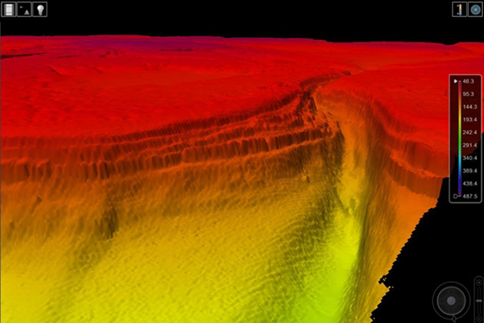
A cluster of reefs on the Admiralty 4001 planning chart

Until an obstacle’s existence is positively disproved, this explains why a cluster of potential dangers to shipping to the east of New Zealand, remains on the official map.
Phantom islands are usually considered something of the past, but even today it is now generally accepted that these islands do not actually exist.
In November 1875, Sir Frederick Evans, newly appointed hydrographer of the British Navy, ordered 123 doubtful islands banished from Admiralty Charts : the corrected chart was designated 2683 for the Pacific Ocean (1:21,830,000).

Other nearby historically reported reefs which may not exist are: Jupiter Reef, Wachusett Reef, and 
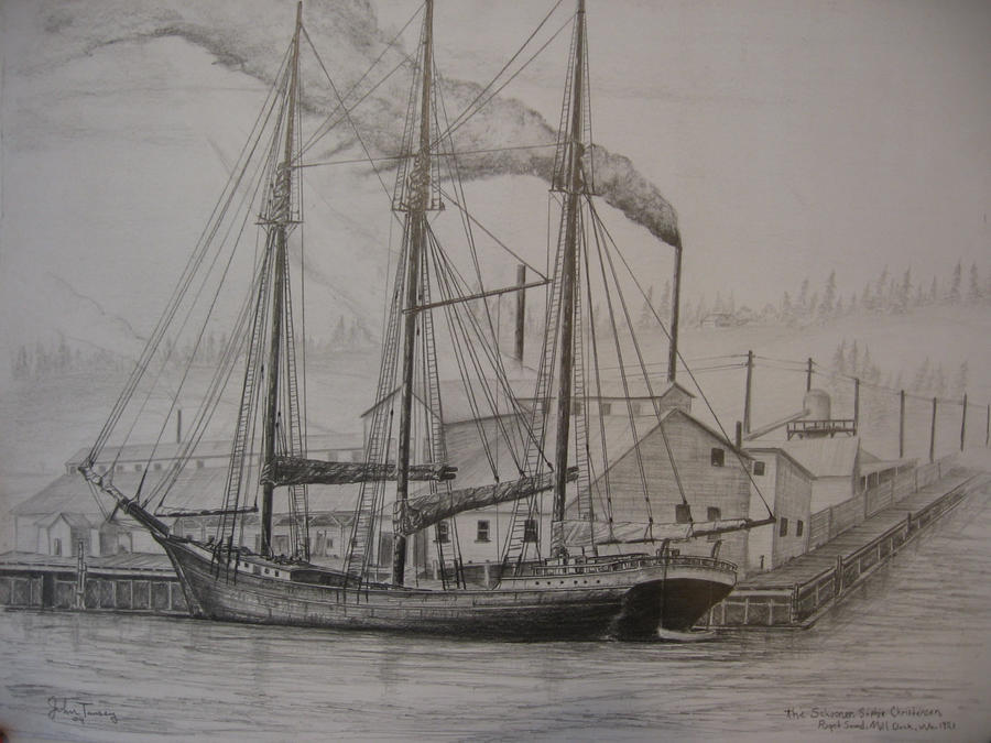
Ernest Legouve Reef and Sophie Christenson shoal.
The historical sightings of these reefs were probably inspired by the supposed existence of Maria Theresa Reef, first reported in 1843.

extract from Grosser Ocean, Andree, Richard. (1881)
David Rumsey collection
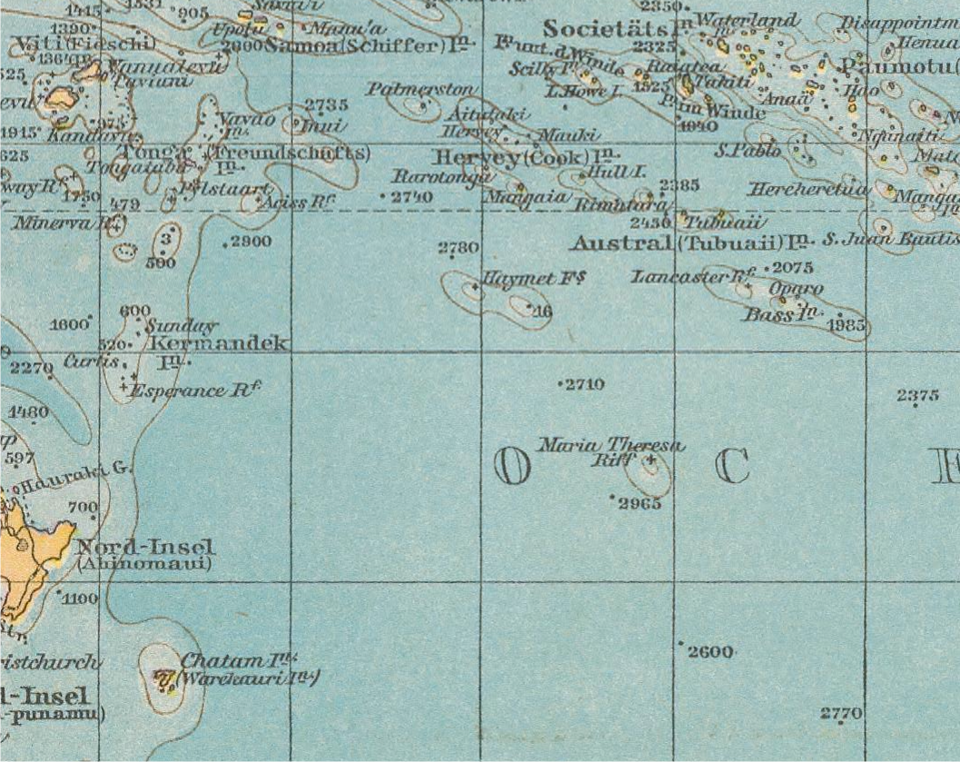
The Maria-Theresa Reef is a supposed reef in the South Pacific (south of French Tuamotu islands and east of New Zealand).
It is also known as Tabor Island or Tabor Reef on French maps.

extract from Ocenanie, Charles Lacoste & J. Migeon, 1895
(David Rumsey collection)

Its position was indicated 16 of November initially of 1843 by naval captain American Asaph P. Taber (nicknamed “Tabor”) that directed to the whaler Maria-Theresa that had weighed anchor of the port of New Bedford in Massachusetts.The coordinates to be situated at 37°00′S / 151°00′W, later adjusted to 37°00′S / 151°13′W that Taber gave were, the news of the possible discovery appeared in the newspaper Sidney Morning Herald for the first time of October of 1853, nevertheless if is observed Binnacle of Taber note that alternates the words to breacker (rompiente coast) and to breacher ("surtidor" of a whale) which makes doubt the initial news of the discovery still more.

In 1957 this island was looked for without success in those places.
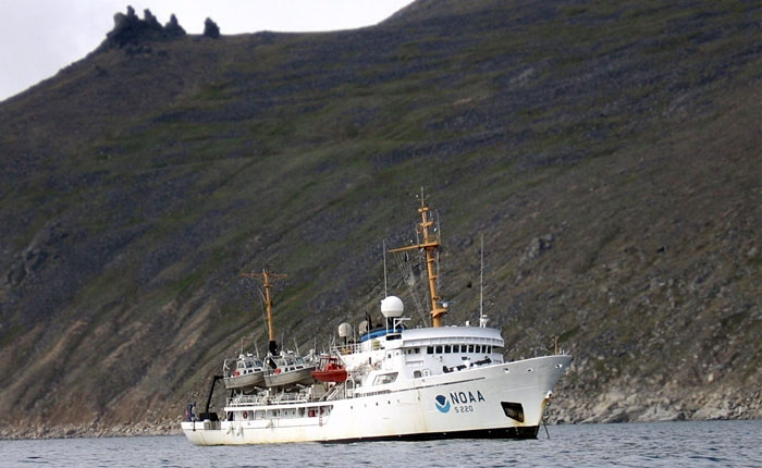
New Zealand's HMNZS Tui made an extensive search of the area in the 1970s and found no shallows or islands.
In 1983 the coordinates were recalculated at 36°50′S / 136°39′W, considering itself like correct, this is: to the south of Tubuai and to more than 1,000 km to the east of the first geolocalization, nevertheless the search in that point also has been unfruitful in spite of the use of satellite photography of hi-res reason why at the moment – although still appears in cartographies – its existence is considered like doubtful, reason why usually is considered in the category of ghost islands.

extract from Pacific ocean, Richard Andree (1895)
(David Rumsey collection)
other map Pacific Ocean, Edward Weller 1898 (National Library of Australia)

An amateur's radio journal "CQ" in 1966 published a photo and description of Don Miller (famous DXer, callsign W9WNV now AE6IY) broadcasting from what he claimed was Maria Teresa Reef.

 
This has been since proven to be a hoax. (document)

extract from Pacific Island (Edward Standford) 1901
(David Rumsey collection)

The depths in the region were shown to be 2,734 fathoms (5,000 m).

 extract from Map of Antarctica (1912) Petermann, A./Habenicht, H./Böhmer, C.

In popular culture, the island appears in Jules Verne's novels In Search of the Castaways and The Mysterious Island.
In In Search of the Castaways (The Children of Captain Grant), the island shelters Captain Grant and two of his crew.
Its coordinates being half-erased in the help message found by the children, it takes them months to find the castaways.
At the end of the book, Ayrton, the renegade, is left in Grant's place to live among the beasts and regain his humanity.
In The Mysterious Island, after they have settled on Lincoln Island, the heroes also find a message in a bottle, but the coordinates and name of the island appear clearly.
They use a small ship to rescue Ayrton, and bring him back to civilisation and rehabilitation. Eventually, the bottle turns out to have been specifically sent to the heroes by the benevolent Captain Nemo.

Other nearby historically reported reefs which also may not exist are Jupiter Reef, Wachusett Reef, and Ernest Legouve Reef.

Even in the 21st Century, some map and atlas publishers still show this fictitious group of reefs in the South Pacific.
Portion of map "Sovereignty and Mandate Boundary Lines in 1921 of the Islands of the Pacific"
, Bumstead, Albert H. and James M. Darley (source)

Captain Lambert of the ship Wachusett reported that on June 4, 1899 he passed over a reef which appeared to be of coral formation in approximately latitude 32°18′S / 151°08′W.
The reef appeared to be about 500 feet wide.
The bottom showed of a dark gray color with deep blue on both sides of the reef.
The depth was estimated at from 5 to 6 fathoms; unfortunately no soundings were taken.
The 2005 edition of the National Geographic Atlas of the World still shows Wachusett Reef, with a depth of 9 meters. (source from Pacific Islands Pilot, v. 2)
Nevertheless, its existence is doubtful.

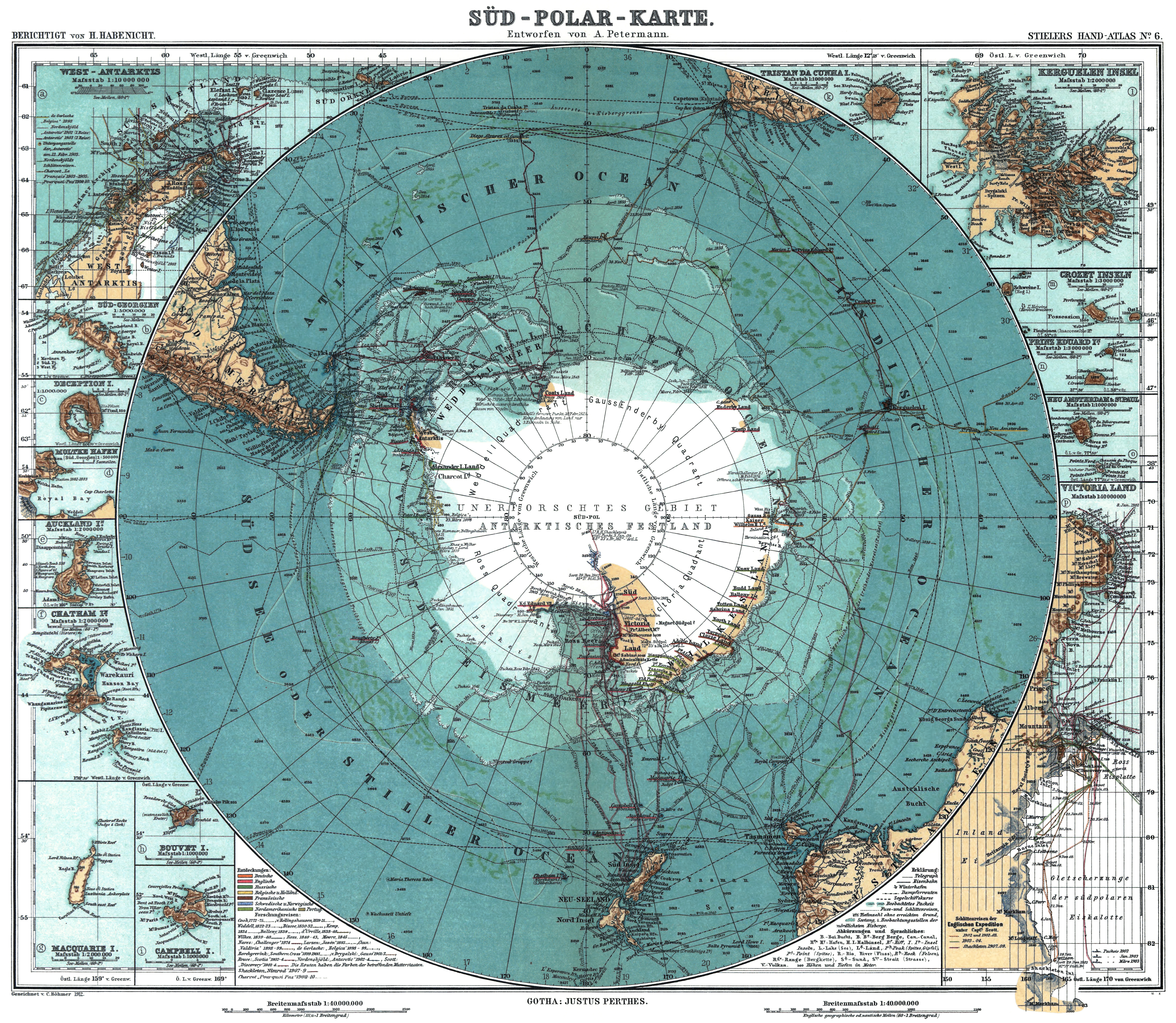
Wachusett Bank and Maria Theresa Reef on the German map of Antarctica 1904
(Richard Andree) source

extract from Commercial Atlas for America (Rank MacNally), 1924
(David Rumsey collection)

 extract from Oceania Politica (Touring Club intaliano), 1924
(David Rumsey collection)


The reef was about 100 metres long and another reef was sighted near it.
The reef was recorded in Paris Notice to Mariners 164/1122/1902, and the International Hydrographic Bureau stated it on February 9, 1957 giving an estimated position of 35°12′S 150°40′W.
It was searched for in 1982 and 1983, but not found leading to it being considered a phantom island. Nevertheless, it is marked in the 2005 edition of the National Geographic Atlas of the World.
Other nearby historically reported reefs which appear to not exist include Wachusett Reef, Jupiter Reef, and Maria Theresa Reef.
In its location and description, Ernest Legouve Reef corresponds to the rock that was said to be all that was left of Lincoln Island at the end of Jules Verne's The Mysterious Island.


Jupiter Reef or Jupiter Breakers is a supposed reef in the South Pacific (south of French Tuamotu islands and east of New Zealand); it appears to be a phantom reef.
Mr. Kinge, commanding the German barque Jupiter on a voyage between Newcastle, New South Wales and Tahiti, reported having passed breakers during the night of December 3rd, 1878, in 36°37′S / 150°15′W.
The breakers were observed in two places, each of which had a diameter of about 30 yards, and appeared to be a quarter of a mile apart.
No further intelligence has been obtained regarding this shoal.

  • Sophie Christenson shoal :
Soviet Union atlas map (1967) 
(David Rumsey collection)

 >>> geolocalization with the Marine GeoGarage <<<
Discovered by 'Sophie Christenson' schooner in 1913.

'Sophie Christenson', an American four-masted schooner built in Port Blakely in 1901.
She was built for the lumber trade and for hauling general cargo.
She was 180.6-feet long with a 38.9-foot beam and a 13.4-foot depth of hold.
She first came to Poulsbo with Captain John Grottle,
and last in 1941 with Captain J.E. Shields, her famous skipper.

Captain J. E. Shields aboard Sophie Christenson

 Book

Seafarer science: sailors asked to help measure plankton


This video shows how they use a Secchi Disk to determine how deep light is penetrating in to the water.
This gives an indication of the water clarity and how much primary production (plankton) may be present.
In turn, this can be related to sightings of filter feeders such as basking sharks.

From BBC

Scientists are enlisting sailors and fishermen to help with what they hope will be the world's biggest study of plankton in the oceans.

Informative film about Plankton (zooplankton; phytoplankton; crustaceans; foodchain)

Plankton are microscopic organisms, key to the marine food chain, but research suggests they are in decline.


Researchers at Plymouth University's Marine Institute want seafarers to help measure the quantity of plankton.
The results will "help us understand how life in the oceans is changing", said project leader, Dr Richard Kirby.
Scientists fear that the population of phytoplankton in the world's oceans is being affected by rising sea temperatures, with a paper published in the journal Nature in 2010 controversially suggesting that it had declined by as much as 40% since the 1950s due to climate change.

 Scientists want seafarers to help collect data on plankton in the world's oceans

Marine life

If this is the case it would have damaging consequences for every aspect of marine life, say researchers.
But data on phytoplankton populations is sparse.
The Plymouth team hope that the readings taken by seafarers will ultimately allow them to test the theory.

The organisms are microscopic, thinner than a strand of human hair, but in large numbers they make seawater cloudy.
In order to measure their populations, seafarers are being asked to drop a white disk over the side of their boats attached to a measuring tape.
They are asked to record the depth at which it disappears from view, and upload the figure to a mobile app.
This information will help scientists estimate the amount of plankton in the sea and how it varies from place to place and year to year.


Along with the Secchi App, all you need do to take part is make a very simple piece of scientific equipment called a Secchi Disk and use it to record the Secchi Depth when you are at sea.

"There are too few scientists to survey the world's oceans as well as we would wish," said Dr Kirby.
"This app enables seafarers around the world to take part in a science project and if we can just get a small percentage of the global population of sailors involved, we can generate a database that will help us understand how life in the oceans is changing. It would help us learn much more about these important organisms at a crucial time when their habitat is altering due to climate change."
"We hope people will take part for many years to come."

Ultimately the plan is to build a map of the oceans to record seasonal and annual changes in plankton populations.
The scientists are hoping that sailors will be prepared to make their own measuring disks which they stress should be 30cm (11.8in) in diameter for uniform measurements.

The app is named after the inventor of the measuring disk, Father Pietro Angelo Secchi, who used it to gauge the cloudiness of the Mediterranean in 1865.
Sailors are asked to take readings whenever they can, but to avoid taking measurements in estuaries. The data they collect will upload automatically onto the Secchi Disk database once they return to port and get a network connection.

Sunday, February 24, 2013

A sneak peak of the 'Penguin Cam' robot infiltrates colony of birds


From BBC

If you think there's something a little fishy about one of the penguins in the picture below, you're not wrong.
Because the bird on the right isn't a real penguin at all, but a hi-tech robot with camera lenses hidden in its eyes.
Award-winning filmmaker John Downer used 'Penguin-cams' to infiltrate colonies of Rockhoppper and Emperor penguins in Antarctica -- and obtain stunning shots of never-before-seen behaviour.

Despite drawing a few quizzical looks, the so-called 'Penguin-cam', which has camera lenses in its eyes, was able to waddle in and mingle with the real birds.
It was also used to 'lay' an 'Egg-cam', which successfully captured charming images of a six-week-old chick peering into it through natural curiosity.

Mr Downer used an array of 50 spy cameras, the most advanced of which cost up to £100,000, to film penguins in Antarctica, the Falkland Islands and Peru.

They included an 'Egg-cam', an underwater 'Penguin-cam' and a 'Toboggan-cam', a full-sized Emperor model which can join a group of real birds by slithering in on its stomach -- in fact a motorised sledge.
Mr Downer said: 'We also employed an underwater 'Penguin-cam' so that we could follow these amazing creatures in their mission to find a safe place to nest and raise the chicks.
'In Antarctica, the emperors brave treacherous sea ice and a trek across the ice of up to 100 miles before huddling together to survive 90mph winter blizzards. We were with them all the way.
'In some of the most moving scenes, we filmed the plight of females who had failed to find a mate or had lost their eggs.

'We witnessed single females doing their best to break up couples by physically disrupting them during mating. Later, alone and without young of their own, they would resort to chick-napping.
'We also recorded evidence of the devotion of penguin pairs who had matched and mated. And extraordinary close-ups that showed how emperor mothers flick their tail feathers to catch the newly laid egg and stop it touching the snow.'


A chance to see amazing images from deep inside the frozen seas of Antarcica.
BBC natural history masterpiece Planet Earth charts the gruelling and heroic winter life of the emperor penguin in almost impossibly cold temperatures.

Links :
  • National Geographic : Paul Nicklen: Emperors of the Ice (Wildlife photographer Paul Nicklen dives beneath the Antarctic ice to capture the "bubbly" emperor penguins in action, and risks being mistaken for his subjects by some very hungry predators.)
  • National Geographic : Emperor Penguins Speed Launch Out of the Water (Photographer Paul Nicklen captures unique video of emperor penguins soaring through the sea and launching their bodies out of the water onto the ice. Scientists have discovered the secret of their speed — bubbles.)