
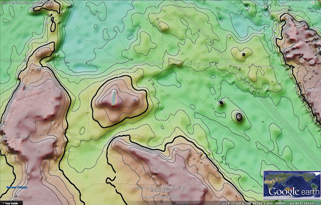
Sandy ghost island with 2008 SHOM nautical map (7321/INT636)
 SHOM ENC
overlayed on Google Maps with transparency
overlayed on Google Maps with transparency
>>> geolocalization with the Marine GeoGarage <<<
From BBC
Sandy island undiscovered
A South Pacific island, shown on marine charts and world maps as well as on Google Earth, does not exist, Australian scientists say.

Google Earth view
but also found in satellite imagery view of Nokia Maps or map view of Bing Maps
using NASA Blue Marble imagery
using NASA Blue Marble imagery

Neither the French government - the invisible island would sit within French territorial waters if it existed - nor the ship's nautical charts, which are based on depth measurements, had the island marked on their maps.
>>> geolocalization with the Marine GeoGarage <<<
 extract of chart 5978 from SHOM (French Hydrographic Office)
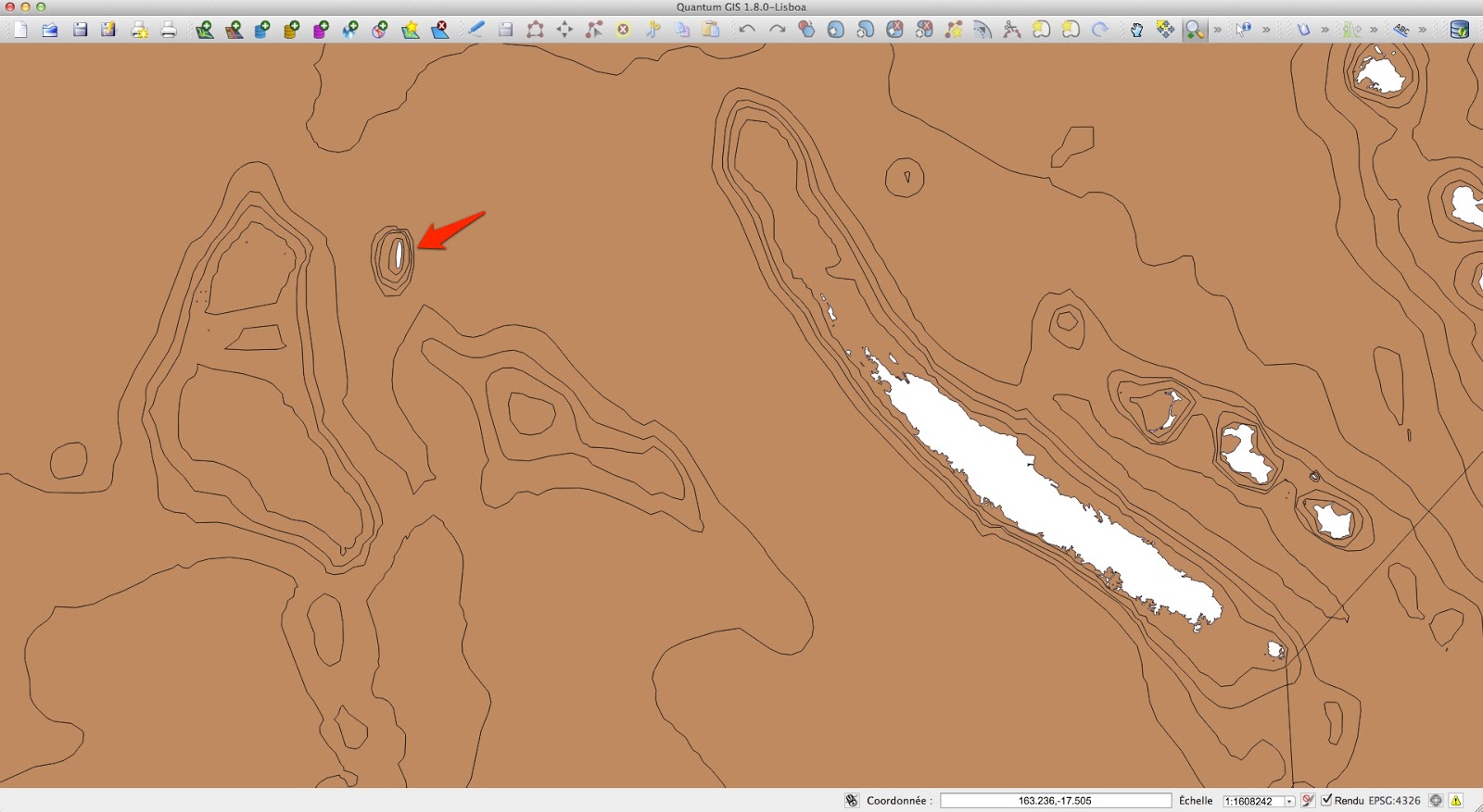
no 'île Sable' in 1982
 Nouvelle Calédonie SHOM ENC official vector chart FR273210 (scale : 1:1,500,000)
(other view with depths in meters)
no 'île Sable' in 2012 update
>>> geolocalization with the Marine GeoGarage <<<

no 'île Sable' in 1982

(other view with depths in meters)
no 'île Sable' in 2012 update
But when scientists from the University of Sydney went to the area, they found only the blue ocean of the Coral Sea.
The phantom island has featured in publications for at least a decade.

Scientist Maria Seton, who was on the ship, said that the team was expecting land, not 1,400m (4,620ft) of deep ocean.
"We wanted to check it out because the navigation charts on board the ship showed a water depth of 1,400m in that area - very deep," Dr Seton, from the University of Sydney, told the AFP news agency after the 25-day voyage.
"It's on Google Earth and other maps so we went to check and there was no island. We're really puzzled. It's quite bizarre.
"How did it find its way onto the maps? We just don't know, but we plan to follow up and find out."


Atlas map : Australian, N.Z. ports (British map 1922)

Soviet Union atlas map (1967)
(David Rumsey collection)
with shoal indication instead of fictional 'Sandy island'
see other ancient maps from Rumsey collection on :
Maps of Sandy Island Through History
the non-existent "Sandy Island" has been drawn (or not) in some maps since the 1770's,
so long before the arrival of satellite imagery
 Karte von Australien oder Polynesien, nach den Zeichnungen Reisebeschreibungen und Tagebücher der vorzüglichsten Seefahrer bis 1789 entworffen im Jahr 1792 (Gallica BNF)
(note : the existence of another 'Sandy island' in the North of New Caledonia island)
with shoal indication instead of fictional 'Sandy island'
see other ancient maps from Rumsey collection on :
Maps of Sandy Island Through History
the non-existent "Sandy Island" has been drawn (or not) in some maps since the 1770's,
so long before the arrival of satellite imagery

(note : the existence of another 'Sandy island' in the North of New Caledonia island)

NGA chart 56 Great circle sailing chart of the North Pacific Ocean
(edition sept 1973)
with shoal indication instead of fictional 'Sandy island'


New Caledonia and Vanuatu bathymetric and topographic map
with 'Ile de Sable'
(also in GeoPortail overview)
 C-Map CM93/2 (2009) commercial vector map view on OpenCPN software
with 'Sandy island'
 Navionics (2012) commercial vector map online view
with 'Sandy Island'
 Great Barrier Reef and Coral Sea bathymetry
in Google Earth (kmz) / e-Atlas
with 'Sandy island'
with 'Ile de Sable'
(also in GeoPortail overview)

with 'Sandy island'

with 'Sandy Island'

in Google Earth (kmz) / e-Atlas
with 'Sandy island'
Australian newspapers have reported that the invisible island would sit within French territorial waters if it existed - but does not feature on French government maps.

Sandy island from the GSHHS worldwide high-resolution shoreline data set (QGIS view)
Mike Prince, the director of charting services for the Australian Hydrographic Service, a department within the Navy that produces the country’s official nautical charts,
said the world coastline database incorporated individual reports that were sometimes old or contained errors.
 Sandy island in the VMAP-0 vector map file,
available from NGA
next version of widely used Digital Chart of the World (DCW)
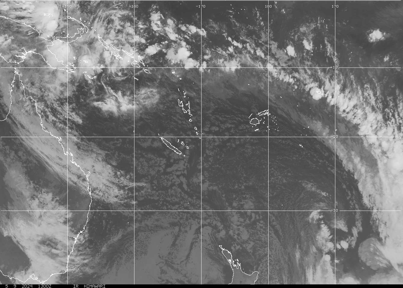
also found in weather satellite picture (GOES NOAA)
 Global gravity (kmz) on Google Earth in the area of the supposed 'Sandy island'
(ref : Sandwell, D. T., and W. H. F. Smith,
Global marine gravity from retracked Geosat and ERS-1 altimetry)
 Measured and estimated seafloor topography (STRM30+) kmz by Google Earth
(ref : Smith, W. H. F., and D. T. Sandwell, Global seafloor topography
from satellite altimetry and ship depth soundings)
which has been directly used by Google or GEBCO (General Bathymetric Chart of the Oceans)
said the world coastline database incorporated individual reports that were sometimes old or contained errors.
available from NGA
next version of widely used Digital Chart of the World (DCW)
also found in weather satellite picture (GOES NOAA)

(ref : Sandwell, D. T., and W. H. F. Smith,
Global marine gravity from retracked Geosat and ERS-1 altimetry)

(ref : Smith, W. H. F., and D. T. Sandwell, Global seafloor topography
from satellite altimetry and ship depth soundings)
which has been directly used by Google or GEBCO (General Bathymetric Chart of the Oceans)
Australia's Hydrographic Service, which produces the country's nautical charts, says its appearance on some scientific maps and Google Earth could just be the result of human error, repeated down the years.
A spokesman from the service told Australian newspapers that while some map makers intentionally include phantom streets to prevent copyright infringements, that was was not usually the case with nautical charts because it would reduce confidence in them.
Mike Prince, the director of charting services for the Australian Hydrographic Service, a department within the Navy, said that while some map-makers added non-existent streets in order to keep tabs on people stealing their data, that was not standard practice with nautical charts.
“[That would] reduce confidence in what is actually correct,” he said.
A spokesman for Google Earth said they consult a variety of authoritative sources when making their maps.
"The world is a constantly changing place, the spokesman told AFP, "and keeping on top of these changes is a never-ending endeavour'.'


indication of 'Sandy island' (discovered by 'Velocity' whaling ship 1876 -photos-) on :
Australia Coral Sea and Great Barrier Reefs
Australia Coral Sea and Great Barrier Reefs
shewing the Inner and Outer routes to Torres Strait,
compiled chiefly from the Surveys of Captains Flinders, King, Blackwood, Stanley, Yule & Denham
RN 1802-60 with additions from Admiralty surveys in progress to 1888
Published at the Admiralty Decr. 19th 1860 under the Superintendence of Capt. Washington, R.N., F.R.S. Hydrographer

indication of 'Sandy island' on
(BNF Gallica)

not any indication of 'Sandy island' on
Brue, A.H., Levasseur, E. Australie, Nouvelle-Zelande. 1875 World Atlas
Brue, A.H., Levasseur, E. Australie, Nouvelle-Zelande. 1875 World Atlas
David Rumsey collection

neither on :
Other ancient maps (BNF Gallica) :
- Carte de l'Océanie contenant l'Australie, la Polynésie et les Iles Asiatiques Par J.B. Poirson, Ing. Géog. Revue par A.Toussaint -Vve. Turgis (Paris)-1832
- General-Karte von Australien, Friedrich H. Handtke, 1889

neither on :
ORSTOM bathymetry map 1979 (other bathy maps 1981 / 1987)
 neither on Transas map
 neither on :
PlanetObserver Landsat satellite imagery (15m) (IGN GeoPortail view)

PlanetObserver Landsat satellite imagery (15m) (IGN GeoPortail view)

neither on :
http://explorateur-carto.georep.nc
or http://carto.gouv.nc (on Google Earth : kmz)
with bathymetric data from SHOM multibeam echo-sounder surveys in 2008
(IRD 'Alis' ship with Simrad EM1002 and IFREMER 'Atalante' ship with Simrad EM12,
isobaths ZEE NC file -pdf map-
surveys tracks SHOM + IFREMER + IRD)

The BBC's Duncan Kennedy in Sydney says that while most explorers dream of discovering uncharted territory, the Australian team appears to have done the opposite - and cartographers everywhere are now rushing to un-discover Sandy Island for ever.
Links :
- SydneyMorningHerald : Where did it go? Scientists 'undiscover' Pacific island
- Wikipedia / Talk
- blog GeoGarage : Lost Islands: the story of Islands that have vanished from nautical charts
ABCNews : Sandy Island 'Undiscovered' After Appearing on Maps
ReplyDeleteDailyMail : How our over-reliance on satellite images led to the mystery of the South Pacific island that wasn't there
ReplyDelete. It has also emerged that the latest non-finding was the SECOND time Sandy Island had been 'un-discovered'
. Radio enthusiasts on an expedition to send a message from the most-remote possible place reported its non-existence in 2000
TheRegister : Sandy 'Mary Celeste' Island undiscovered - again : Radio hams beat science by a decade
TheGuardian : Pacific's Sandy Island found not to exist – video
ReplyDeleteMr Sabin Zahirovic, PhD Candidate, School of Geosciences, Faculty of Science of the University of Sydney sent the additional comments to the GeoGarage team after reading our article :
"We spent 25 days out at sea collecting rock samples from 18 locations, continuously recording the swath bathymetry, gravity and magnetic anomalies, and other geophysical parameters.
So this little detour was actually just a bit of fun, and it turned out to at least settle whether this island exists or not.
We didn't understand why the area was blacked out, because that seems to be reserved for sensitive military bases.
So it was very bizarre!
Our satellite-derived bathymetry didn't show the island, but we couldn't trust it because in other locations we found the satellite bathymetry inferred from gravity anomalies was way off in terms of the depths we measured.
So we had all our scientific and weather maps and atlases saying there was an island, but the one and only navigational chart showed nothing.
Although we would obviously trust navigational maps, that part of the world had barely any ship tracks or coverage from research vessels so we didn't know what to expect!
I have to admit that I was a little nervous when we approached, because it was the middle of the night!
But in this instance we found the depths from the satellite-derived bathymetry largely matched with what we were seeing on our instruments, even though the same satellite derived bathymetry was wrong for nearby areas.
Seems to be related to the density of the crust in this region - whether it is volcanic, or continental/sedimentary, or tectonic-influenced seemed to dictate if the satellite-derived bathymetry did a good job in representing the actual depths.
Satellite derived bathymetry relies on gravity anomalies and how they correlate to topography on land - and extrapolated to what you'd expect under the water.
However, we found in many places the gravitational anomalies from huge sedimentary basins or from recent submarine volcanism shifted the depths by hundreds of meters.
This was also very significant in areas that had lots of steep slopes, from faults and other tectonic processes - where the satellite derived bathy would show a gradual change in slope, the actual slope was much higher due to the better precision and resolution from swath bathymetry. "
Mystery island on 1908 map
ReplyDeleteIntrigued by the mystery, Auckland Museum's pictorial librarian Shaun Higgins went looking through the museum's vast collection of maps, which dates back as far as the 1700s.
Eventually, Higgins found a 1908 map which showed the island, which appears to be about the size of Great Barrier in the Hauraki Gulf.
According to the map the island was discovered by the ship the Velocity in 1876 - but on the map was a caveat that warned the information may not be reliable, as it was gathered over a number of trips.
A note on the map reads: "Caution is necessary while navigating among the low-lying islands of the Pacific Ocean. The general details have been collated from the voyages of various navigators extending over a long series of years. The relative position of many dangers may therefore not be exactly given."
Higgins said how the island managed to appear, disappear and reappear on various maps and charts over time was "a mystery of the sea".
Auckland Museum blog
Detail from the 1908 map showing Sandy Island in the Coral Sea
GMT mailing list : E-mails from Walter H.F. Smith (NOAA Laboratory for Satellite Altimetry, Paul Wessel (GMT) with Maria Seton
ReplyDeleteFrom Hydro : It’s on the Map – But Does it Exist?
ReplyDeleteThe AHS has an explanation for the rather old phenomenon. The ‘phantom’ island was reported to the officers of HMS Barracouta as an unconfirmed sighting of ‘a line of sandy islands’ by the Master of the whaling ship Velocity in 1876. It was shown on charts with the legend ‘reported 1876’ beside the feature, the inference being that it may not exist. The report included an approximate extent for the line but no shape or size of individual features, though by 1888 it was charted as a single unconfirmed shoal with a similar extent to the modern World Vector Shoreline and subsequent Google Maps version. The reported position is also likely to have been highly approximate by modern standards as a result of the navigation systems in use at the time it was reported. As an example of a similar feature, the current edition of INT602 produced by the Australian Hydrographic Service (AHS) shows another doubtful shoal further east with ‘ED’ beside it – by modern international convention this stands for ‘existence doubtful’ (see bigger version of the chart at the left, right of the red circle).
The phantom island recently ’undiscovered’ was removed from the Australian produced International charts on 22 March 1985 following a deliberate and controlled search by the AHS. This search specifically proved it did not exist, along with other similar features elsewhere in the region, and was undertaken as part of a larger survey elsewhere in the South Pacific. This information was promulgated to both mariners and all other national hydrographic organisations reproducing INT 602 via Notice to Mariners 161 of 1985.
The 1985 survey found evidence of a submarine volcano at a depth of around 1,500 metres and noted areas of floating pumice. Based upon this, it is now strongly suspected it may have been an area of floating pumice which was sighted in 1876, though the extent of individual patches was probably much smaller than the Google Earth image infers, and would have been quite temporal, lasting no more than a few months at most. Cruising sailors have photographed similar features elsewhere in the South Pacific – the effect looks very convincing.
While it was removed from US charts several decades ago, the AHS is aware that the US National Geospatial Intelligence Agency (NGA) had reason as recently as two years ago to advise Google when they went live with their oceans dataset that the island as shown in their data was erroneous. The image on Google Earth has been clearly altered, by either accident or design, but bears none of the characteristics of any other reef, shoal or island that can be seen nearby. While many aspects of Google Earth are most impressive, by trying to provide a global view, they (and similar organisations providing global datasets) appear to have a limited capability to note conflicts between datasets that are only apparent at a detailed level. In this instance, even without relying on the advice from NGA, the mismatch between their ‘surface’ map showing the island and the ‘seabed’ imagery around it should have been sufficient to flag doubt and prompt a search of more authoritative and up to date sources
TheInterpreter (Olivia Wilson, Hydrographic Surveyor at Geoscience Australia) : Sinking Sandy Island: A data-sharing parable
ReplyDeleteTheInterpreter : Reader (Mike Prince, Director of Charting Services at the Australian Hydrographic Service) riposte: Mapping Sandy Island
ZoNeCo 3 and 4 (ORSTOM-IFREMER), undertook a survey aboard L’Atalante from 17 September 1996 to 20 January 1997 in the d’Entrecasteaux Reefs and the Chesterfield Group to survey morphobathymetry in New Caledonia waters as part of the ZoNeCo program which is devoted to the evaluation of the economic potential (fisheries and mineral resources) of the New Caledonia EEZ.
ReplyDeleteSOPAC
swath mapping in ZoNeCo3&4
More than 200,000 square kilometres have been mapped with complete coverage.
About 150 volcanic features less than 1000 m deep have been discovered or precisely located.
1700 square kilometres of oceanic bottom shallower than 500 m and 15000 square kilometres shallower than 1000 m have been mapped but not in the area of 'Sandy island'
ZoNeCo_bathymetry_area_1996
ZoNeCo_bathymetry_1996
SHOM Press Release (12/12/2012) : Sandy Island :
ReplyDeletele mystère de l’île fantôme dévoilé depuis déjà 33 ans
(translated in English)
The mystery of the ghost island already unveiled 33 years :
Ghost Island Sandy Island is back in the spotlight these days while the case was finally settled in 1979.
On the occasion of a campaign about the study of the tectonic evolution of the Coral Sea, the Australian research vessel Southern Surveyor found no land mass to the presumed position of Sandy Island. The opposite would have been surprising because since 1979, and to end many doubts about the existence of this island, SHOM has commissioned several aerial reconnaissance with a Maritime Patrol Aircraft (Neptune P2H) of the Navy in New Caledonia, who concluded to the absence of this island. The island has been deleted documents by water notices to mariners in March 1979. It should be noted that the position in question is located in the exclusive economic zone between the French and the Chesterfield Islands New Caledonia and the mapping to the largest international scale (1: 1 500 000) the area is under French responsibility (INT chart and ENC 636 / FR273210).
The official charts meet the safety of navigation objectives and are subject to a rigorous process of developing and updating. This example demonstrates once again the importance of using reliable and official hydrographic services. They carry a collection assets in their areas of responsibility of all available information and transcribe on nautical documents after a critical analysis. It is also in this context, and in accordance with the provisions of the Convention on the Law of the Sea under the marine scientific research in waters under the sovereignty, the data collected by the Southern Surveyor will be transmitted to the SHOM to be used to enrich the charts.
The Pacific Ocean is vast and bathymetry is far from being well known. It is still possible that undetected seamounts can flush at the surface, the existence of islands, most of the alleged extent of Sandy Island (25 km), not on the official charts, is highly unlikely at the time of satellite imagery. Sandy Island was reported by a whaling ship in 1876. Two hypotheses may explain this misunderstanding by the whaler: a positioning error (in the 19th century, the position at sea was sometimes vague and often with random errors in longitude. Without definitive conclusion we can see that the presumed position Sandy Island is located just 1° East of Bampton reefs which really exist.) or a misidentification (if Sandy Island does not exist as an island, an underwater volcano is well located at this position and the presence on the surface of volcanic residue floating in some cases may suggest the existence of land).
ReplyDeleteWith a bathymetry still incomplete for many years because of the extent of ocean space,
but which should rise from hydrographic vessels, other techniques such as satellite altimetry are implemented to detect the seamounts. However, if this technique can effectively detect the presence of significant relief, it does not allow to determine depth with precision and if the relief is likely to constitute a hazard to navigation or surface diving, some hydrographic survey may be needed to make a more specific area. In 2008, SHOM analyzed altimetry data of the suspected area of Sandy Island. The anomaly in the open air of 80 mGal can be observed in the data indicates a high probability of the presence of a seamount, seamount which was actually found by the Southern Surveyor. This mountain-submarine was already on the charts at a depth of 1474 m. Characteristics could be specified after the use of data from the Southern Surveyor.
The anomaly in the open air is the gravity anomaly in which the altitude correction is made using the rate of variation in the open air of gravity, without trying to correct the effect of topographic masses (definition dictionary of the International Hydrographic Organization).
Links :
SHOM : NtM (March 1979)
SHOM : gravity anomaly
National Geographic : Sandy Island (Île de Sable or Île de Sables): The Island That Never Was
ReplyDeleteAn Australian scientific expedition sailed past the location where Sandy Island (Île de Sables) in the Coral Sea should have been and found nothing but open water.
Appearing on nautical charts and maps as far back as the early 19th century, this phantom island has erroneously been a “pick-up” by cartographers ever since.
Its existence, as portrayed below in National Geographic’s 1921 Sovereignty and Mandate Boundary Lines of the Islands of the Pacific map, or lack thereof, was made that much perplexing by the mere fact that the island appeared on some image based dynamic mapping applications.
National Geographic’s 1921 Sovereignty and Mandate Boundary Lines of the Islands of the Pacific map
GIM International : Sandy Island mystery solved 33 years ago
ReplyDeleteHydro International : Sandy Island Solved by SHOM in 1979
ReplyDeleteAnchorage Daily News : Scientist tries to unravel mystery of Coral Sea's ghostly island
ReplyDeleteHow a fake island landed on Google Earth
ReplyDeleteGISLounge : the map myth of Sandy Island
ReplyDeleteArsTechnica : The story behind the island that wasn’t there, How a 1908 error managed to persist through the satellite era.
ReplyDeleteGEBCO : "Disappearance" of Sandy Island
ReplyDeleteGEBCO : "Disappearance" of Sandy Island
ReplyDeleteThe Travel : Sandy Island: Google's Disappearing Island
ReplyDeleteNews18 : Spotted On Google Maps, Experts Fail To Locate Phantom Island In Pacific Ocean
ReplyDeleteExpress : Mystery island that vanished without a trace after 200 years on the map
ReplyDelete